
Fine, if damaged, saddle quern made from igneous rock. The quern was excavated in 1862 from one of the huts in the group. On display in the British Museum.
Image credit: A. Brookes (4.11.2012)

Fine, if damaged, saddle quern made from igneous rock. The quern was excavated in 1862 from one of the huts in the group. On display in the British Museum.

Astonishing amber necklace with gold discs, excavated from the Lake group of barrows. On display in the British Museum.

Grave goods from the destroyed barrow, on display in the British Museum. L-R: Beaker, bone/ivory toggle, stone “wristguard”, copper dagger.
“This group of items was buried with the crouched body of an adult male. The highly finished wristguard of polished green stone with gold stud caps was deliberately broken before burial. The polished toggle or pendant was probably made from sea-mammal ivory.”

Grave goods from a Beaker “flat grave” discovered during chalk quarrying in 1968, near Sewell, Bedfordshire. On display in the British Museum. L-R: Beaker, bone toggle, copper pin, stone “wristguard”.
“This grave contained the crouched body of an adult male. The wristguard and pin lay on the left arm. The toggle lay at the chest and the beaker at the feet. A second adult male was later placed above the first, but without personal grave goods.”

Copper Age (2500-2100 BC) grave goods found during chalk quarrying in 1883 near Sittingbourne in Kent, on display in the British Museum. L-R: stone “wrist guard”/bracer, copper dagger, bone toggle/belt fitting.

The Folkton Drums, on display in the British Museum.

Bronze Age collared urn from round barrow at Stockbridge. On display in the British Museum.

The steep northwestern slopes of the fort are on the left. Seen from Cwm Col-huw as the sun sets.

The sun setting off the shore of North Devon, from the beach below the crumbling cliffs of Castle Ditches. Nash Point is over to the right.

The westernmost tip of the promontory fort.

The eastern ramparts viewed from the open interior of the fort.

Looking north along the innermost of the eastern ramparts. This small section is the only part of the defences not heavily overgrown.

Halfway along the northern ramparts, as they curve southeastwards.

The middle rampart on the north of the fort. Looking east.

The inner rampart on the north of the fort, the least overgrown part of the defences.

The path to the Coast Guard watch post runs along the ditch between the two inner ramparts of the heavily overgrown western defences. Looking north.

These steps are built into the western ramparts, ostensibly to provide ease of access to the Coast Guard watch post, but they also emphasise the depth of defences (the ditch is in the bottom between the steps) and will help to minimise erosion from the coast path that crosses here.

The only visible part of the easternmost rampart is where the footpath crosses it into the fort. The rest is entirely covered in thick vegetation that would take a machete army to make inroads into.

The southern defences are provided by vertical (and crumbling) sea cliffs. I wonder how much further the fort extended 2,000 years ago? The cliffs are receding and unstable.

Summerhouse Camp (centre, under trees) seen across the bay from Limpert.

Reverse of the previous image, SW corner of the fort. Unfortunately there’s been some fly-tipping here.

What appears to be an entrance at the SW corner of the fort. Not sure if this is an original feature.

Standing on the inner western rampart.

Looking along the ditch between the western ramparts. The established trees show that this fort has been wooded for a fair while.

The western ramparts, looking south.

Heavily overgrown ramparts at the NW corner of the fort.

Info at the entrance (in the caravan site).

Dusk, Coed Aber settlement.


Standing stone built into the round house near Aber Falls. Looking towards Llwytmor Bach.

What Coflein describes as an excavated round house/corn-drying kiln and standing stone near Aber Falls.

Hut circle on the way to Aber Falls at approx. SH664714. Sorry for the gloomy picture, the light in the steep-sided valley was failing a bit by this point.

Looking down on the site from the track on the hillside to the east.

Aerial view of two of the roundhouses in the northern cluster, from the track on the hillside to the east.

General view of the setting, from the SE.

Another circle in the northern cluster.

Massive roundhouse in the northern cluster.

Some impressively massive stonework in the settlement.

In the southern cluster.

Fainter, less well-preserved hut circle within the settlement. Looking south.

Another of the southern cluster, looking west to the Afon Glaslyn tumbling down the hillside opposite.

One of the southern cluster of hut circles, nearest the modern buildings. Looking NE.

The view towards Yr Wyddfa.


The little stone in the wall next to the cairn.

Looking ENE down the Dyffryn Mymbyr.
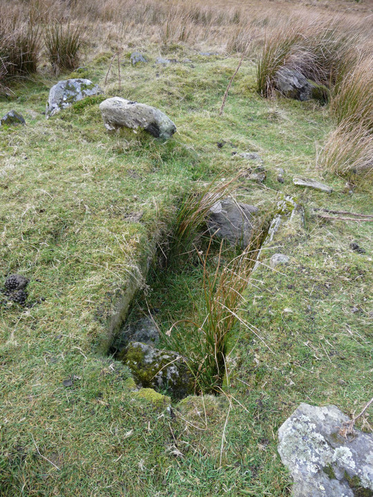
As fine a cist as you could find, and that’s without the views.

A reverse of the view from the circle. The position of the circle is visible from the summit of Y Lliwedd to the southwest. Crib Goch is top left.

Detail of stones in the eastern arc.

Detail of stones in the western arc.