
The view towards Yr Wyddfa.
Image credit: A. Brookes/C. Bickerton (17.11.2012)

The view towards Yr Wyddfa.


The little stone in the wall next to the cairn.

Looking ENE down the Dyffryn Mymbyr.
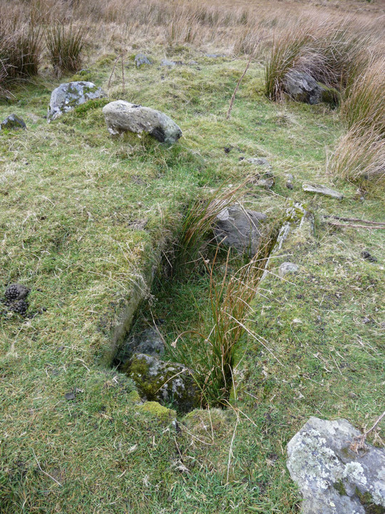
As fine a cist as you could find, and that’s without the views.

A reverse of the view from the circle. The position of the circle is visible from the summit of Y Lliwedd to the southwest. Crib Goch is top left.

Detail of stones in the eastern arc.

Detail of stones in the western arc.

General view looking ESE. The dark mountain on the skyline is Carnedd Moel Siabod.

Slender stone in the southern arc.

General view from the south as the sun broke through.

Looking across the circle from the NE. The off-centre central stone (in the largest pool) appears to be natural rather than obviously part of the ring, which otherwise consists of slender stones, including the fallen example at the bottom of the picture.

The setting is very waterlogged.

The SW quadrant, looking towards twin-summited Y Lliwedd and the elegant north-eastern profile of Crib Goch.

Stones of the western arc, looking north to the Glyderau summits, now in sunshine.

Postie respectfully asks the tree for directions.

Some kind of landscape perspective. Cloud boils over the Glyderau as we start the walk up from Pen y Gwryd to the SE. The circle is hidden from view in a natural amphitheatre below these towering rock faces.

Looking across the open fort interior at the end of a fine day’s coast walk.

By the time we made our way up through the steep southeastern approach to the fort, it was getting quite dark.

The wooded fort from the NE, as sunset approaches.

Cold Knap Point seen from Porthceri Park, in the shadow of The Bulwarks promontory fort.

An aerial view of the headland (right of centre) and Friar’s Point (left of centre) from Bull Cliff. On the far horizon Steep Holm island and Brean Down (barrows, hillfort) in Somerset can be made out.

Cold Knap Point from the pebble beach to the NW.

Friar’s Point from Cold Knap Point to the west, showing the exposed diagonal sedimentary nature of the headland.

The now-empty headland of Cold Knap Point, looking inland.

Looking west from Cold Knap point to the Bulwarks promontory fort (wooded, centre). If the blue dot on Coflein is indicative, the destroyed barrow would have been roughly where this picture was taken from.

Cold Knap point from Little Island. Nice location for a coastal barrow, but sadly it’s gone now.

Friar’s Point pillow mound (to the north of the cairns on the headland). This is shown on the OS 1/25000 as one of the “cairns”.

Cairn III’s reduced stonework (foreground) with the wrecked Cairn II beyond.

Cairn III, showing poorly preserved arc of stones on the western and southern sides. Looking NNE. Cairn I can be seen as a darker green shape in the upper left of the picture, Whitmore Bay over to the right.

Greatly reduced Cairn III, looking WNW.

Cairn I, showing apparent excavation scoop. Looking west towards the next headland, Cold Knap Point, which also had a (now destroyed) barrow on it. Beyond that, the coast of South Glamorgan stretches towards Rhoose Point, the most southerly point on the Welsh mainland.

Friar’s Point Cairn I, looking NW across Watch House Bay.

Cairn I, looking south towards the wreck of Cairn II.

“Sully, under the rainbow”. From Friar’s Point, Barry Island.

Friar’s Point seen across the golden sands of Whitmore Bay. Gavin and Stacey visible bottom right.

Sully Island (an island again) from Barry Island (not an island).

Sully Island (still attached to the mainland) from Hayes Point, a mile or so to the west. The island over to the right is Flat Holm.


Back on the Whelk’s trail. Sully Island from Swanbridge, low tide.

Arthur’s Seat from the southwest.

The fort in its context, in the shadow of Arthur’s Seat. The flat-topped fort can be seen on the far right of the picture. From the west.

Most of the lumps and bumps in the fort interior are probably naturally rock outcrops, rather than the remains of man-made structures.

Circular(ish) flat area in the centre of the fort. Could this represent a building platform?

The rocky interior of the narrow fort, looking east.

Looking west from the fort interior. Edinburgh Castle, site of another hillfort, can be seen left of centre, Salisbury Crags on the right.

The very steeply sloping southern side of Samson’s Ribs, providing natural defences. Looking SE.

Looking westwards along the natural gully (deepened by the building of Queen’s Drive) that separates Samson’s Ribs (left) from the cliffs below Arthur’s Seat (right).

Duddingston Loch from the eastern end of Samson’s Ribs fort.
