Image credit: A. Brookes (19.12.2020)


Cairn-like pile of smaller stones close to the site.
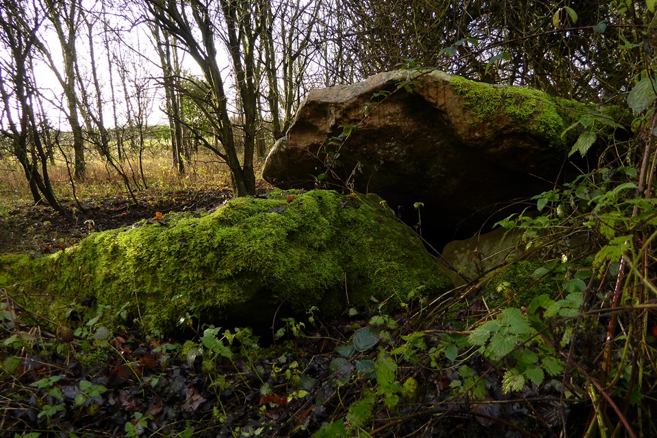

Smaller, blocky stone set a little way apart from the main group of stones.
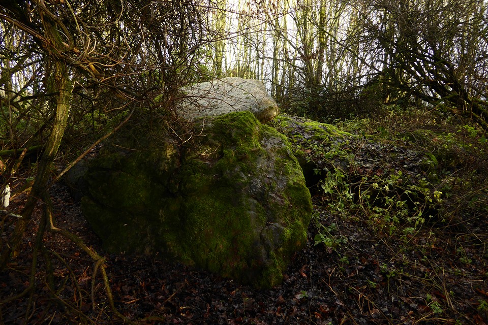
Midwinter golden light on the stones.

Plan of long barrow prior to it’s destruction in 1955
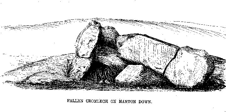
Fallen Cromlech on Manton Down
From “Guide to the British and Roman Antiquities of the North Wiltshire Downs” by Revd. A. C. Smith, M.A. – 1884
Manton Down Barrow Destroyed.
Discovery by Youth Hostel Party.
From our correspondent, Swindon, April 27.The Long Barrow at Manton Down, near Marlborough, Wiltshire, which is believed to date from about 2,200 B.C., has been destroyed. Its destruction was discovered yesterday when a party of Youth Hostel Association members were taken to inspect the tumulus by Mr. N. Thomas, curator of Devizes Museum, and Mr. L.V. Grinsell, curator of the Department of Antiquities, City Museum, Bristol. Trees in the area had also been cleared.
Large stones which composed the barrow are scattered over a fairly wide area. Gathered around a solitary small tree are big sarsen stones at the point which was probably the burial chamber. Some now stand on edge. In a half circle from the rubble which originally composed the mound are groups of uprooted bushes and trees.
Mr. Thomas said to-day: “Mr. Grinsell and I are reporting the matter to the chief inspector of monuments at the Ministry of Works.” The title of the barrow, he said, was something of a misnomer. It was, in fact, one of the shortest of the barrows, of which there are several in the locality. He put its length at about 80ft., and it would, he thought, have been about 3 ft. to 4ft. high. It was scheduled as an ancient monument.
Featuring my favourite folklore icon, Mr Grinsell. From The Times, April 28th, 1953. Can you imagine their faces (or the language). The next part of the story is in another post below.
The ”Fallen Kistvaen” lies about three quarters of a mile due south of that in Temple Bottom, and owing to the heath and furze which abound thereabouts is not easily discovered. Parts of the mound which once covered it, and some of the stones which apparently surrounded it, are still to be seen.
When I first became acquainted with it – some twenty-five years ago – the covering stone, a very massive slab, was entire, but one or more of its supporters having given way, it had slid from its original position, and rested on the ground, still, however, in part upheld by some of its props; and thus, though fallen, presenting an interesting specimen of the kistvaen.
When, however, I visited it about ten years since (and I generally do visit it annually), judge of my dismay at finding the capstone split across by some workmen, who – ignorant that it differed in any respect from the many other sarsen stones lying all round – had selected that unfortunate stone for some building purpose. To arrest the work of destruction was not difficult, for on communication with the then owner, Mr. Baskerville, orders were immediately given that the stones should be spared; adn now that the property has passed into the hands of the noble President of this Meeting, we need not fear any farther injury to it.
The indifference of the stone-masons to the covering stone of the kistvaen is not so surprizing when even so good an antiquary as Aubrey relates how he and Dr. Charleton pointed it out to His Majesty Charles II. and the Duke of York as one of the stones intended for Stonehenge, and “resting on three low stones, as a suffulciment as in order to be carried away”!
On British Stone and Earthworks on the Marlborough Downs by the Rev. A C Smith, in the Wilts Arch Nat Hist Magazine, v19, 1881.
Details of site on Pastscape
(SU 1515 7140) Burial Chamber (NR) SU 1513 7140 Manton Down Long Barrow. Length 65’; width 35’; height 3 1/2’. No 11 on Wessex map. (2) The remains of the burial chamber were at the E end and could not have been more than 6’ square internally (3) (4). Traces of an orthostatic revetment are still visible (4) and one outlying stone at SE corner of the could be remains of the peristalith. (3). Hoare (5) refers to the mound being “set round with stone” and Mrs Cunnington (6) noted three or four stones being partly buried c 1913. Has been levelled by a bulldozer. A rescue excavation was carried out by R J C Atkinson in 1955. Publication forthcoming.
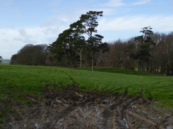
There are no surface indications of this long barrow in the arable field. 5 large sarsen slabs and numerous smaller sarsens lie in a patch of scrub centred SU 1513 7141 immediately adjacent to the
barrow site; it is probable that some formed the burial chamber (see illustration card) Sited on 1:2500 Description of the site and history of antiquarian and archaeological investigation, including a summary of Atkinson’s excavation. Barker also states that the remains “are shown on all OS maps at SU 15137140,while they actually stand some 350m to the west at SU 14787135”. (10)
The site of the long barrow is located within the area mapped at 1:10,000 from APs by the Fyfield Down and Overton Down Mapping Project. In the light of Barker’s comments, an attempt was made to determine the barrow’s true location. Information received from Prof PJ Fowler suggested that Barker’s assertion was based, in part, on a site visit during which he apparently found a pile of stones in a hedge at his preferred location. Two slight mounds were recorded from APs in the vicinity of Barker’s revised location, but are probably abraded field system lynchets. At the location originally given on OS maps (SU 15137140) most APs from 1946-1982 show a clump of rough vegetation covering an area of disturbed ground and obscuring surface detail, although CUCAP photographs taken in 1954 show an area of bulldozer damage at this spot. It seems likely that the stones noted by Barker had been moved by bulldozer from their original location, and that the grid reference indicated on OS maps is correct. (11-13)
“Discarded long barrow, Manton Down, as dumped in 1996 – the end (or just another phase?) of a long story of abuse of a chambered long barrow which was a Scheduled Ancient Monument supposedly protected by law; but it made the big mistake of being in the way of agricultural land improvement in the 1950s and has subsequently been totally destroyed. This presumably final resting is about a quarter mile (c.400m) from the place where these stones were built into a tomb some 6000 years ago, a tomb which was respected by prehistoric farmers when cultivating their fields 2000-3000 years later. And 3000 years later again – progress? What progress?”
Text under a photo of the destroyed barrow in “An English Countryside Explored – The Land of Lettice Sweetapple” by Peter Fowler and Ian Blackwell
The Manton Down Long Barrow (Neolithic Wessex Map, No.11).
This tomb, sometimes referred to as Doghill Barrow, was again noted by Aubrey, though not I believe by Stukeley, and it received passing mention from Colt Hoare. It is here planned for the first time and is a short oval cairn (with no trace of side ditches) about 60 by 35 feet. At the south-east, higher, and slightly broader end, are remains of a small rectangular chamber, two stones of which remain upright, while others are prone beneath the fractured capstone, which leans on the remaining upright of the south-west side. The dimensions of the chamber are uncertain, but its internal measurements can hardly have been more than six feet square. There is one outlying stone at the southern corner of the mound which may be the remains of a peristalith otherwise vanished—Colt Hoare observed that in his day ” the mound appears to have been set round with stones”, and some remained until about 1913. The small squarish chamber opening more or less directly on to the facade is paralleled in the Cotswolds at, for instance, Randwick, while St. Nicholas (Glam.) is not dissimilar. In Dorset, the Grey Mare and her Colts seems to have an analogous plan, though here access to the chamber must have been made from the side. At Manton it is difficult to judge without excavation, but a frontal entrance seems reasonable to assume from the stones as they now remain.
Notes on some North Wiltshire chambered tombs
By Professor Stuart Piggott F.S.A.
W.A.M. 52 Page 60-61 – 1946
The sorry tale of the long barrow on Manton Down; from The Times, April 29th, 1953.
An inspector from the Ancient Monuments Department of the Ministry of Works is to visit Manton Down, near Malborough, Wiltshire, to-morrow to examine the site of the 4,000-year-old Long Barrow, which has been destroyed.
Mrs. Todd, wife of Mr. G.E. Todd, a farmer and racehorse trainer who lives at Manton House and owns 1,000 acres of the surrounding countryside, to-day confirmed that the barrow was on her husband’s property – in a cattle enclosure about a quarter of a mile from the house. She informed your Correspondent that the damage had apparently been done last year when the farm was let to Mr. J. E. King, a farmer who now lives at Tuffley Park, Gloucester. The enclosure was then in a bad state, overgrown with thorn bushes and infested with rabbits.
Mr. King told your Correspondent to-day that he had had the bushes removed by a bulldozer last summer. This was to make the rough land ready for ploughing, since he intended to sow it with corn. He said that the Wiltshire agricultural executive committee at Trowbridge had known of his intention; in fact, they had had the enclosure measured for him and were going to give him a grant to plough the land. He said he saw several large stones, but they were too big for his men to move. He said he was not told of any burial mound on the land.
Mrs. Todd also told your Correspondent that neither she nor her husband knew anything about the barrow. When he bought the property in 1947 he was not given or told of any documents relating to the barrow.
A spokesman in the Ancient Monuments Department of the Ministry of Works, which today received a report from Mr. N. Thomas, curator of Devizes Museum, said that “a most serious view” was taken of the destruction. He said there was no reason for ignorance on the part of a property owner that there was a scheduled monument on his land. Various steps were taken to let an owner know that a monument had been scheduled. He was given notice of the fact and received a map showing where the monument was.
Manton Long Barrow was scheduled as an ancient monument in 1922.
The next day an article in the paper included this:“Mr G.E.Todd, of Manton House.. said later that the inspector had advised him to replace the earth round a group of large sarsen stones which surround a solitary elder bush at one end of the barrow..”
It makes you wonder if any stones remain to be seen at the site. I have taken the grid reference (SU14787135) and alternative name from ‘Long Barrows of the Cotswolds and Surrounding Areas’ by Timothy Darvill (2004).
Having said that, I spotted this thread
themodernantiquarian.com/forum/?thread=8482
which mentions that the stones were moved as recently as 1996? and could even be in Fyfield now (quite a way from their source).