Plan showing the magnetometer survey carried out on behalf of the Avebury World Heritage Site Management Officer to accurately locate the barrow so it could be ‘removed from cultivation’.
Image credit: English Heritage
Plan showing the magnetometer survey carried out on behalf of the Avebury World Heritage Site Management Officer to accurately locate the barrow so it could be ‘removed from cultivation’.

The remains of the barrows southern side ditch. The south street lane which bisects the barrow can be seen, along with a strip of land left uncultivated, marking the side ditch’s position.

The remains of the barrows southern side ditch can just be seen as a strip of land left uncultivated.

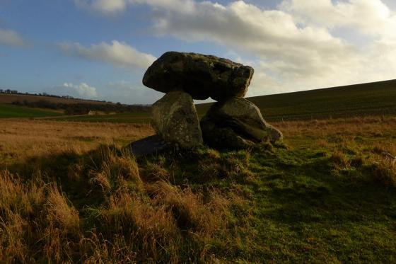
The remains of the barrow can be seen as a darker patch covered with danelions. Adam and Eve standing stones in the background.

The remains of the barrow looking north towards the Adam and Eve standing stones

Ground Plan of South Street Long Bartrow as Excavated between 1964 & 1967
Visited 15.7.10.
There was waist high grass all around and although I did notice a slight rise to the south east of the Adam and Eve stones I don’t know if it was the barrow or just a natural bump in the ground?
South Street Long Barrow SU 0902 6928 (Avebury G 68)
This long barrow has been greatly reduced, so the majority of these field notes will consist of the report on the barrow from W.A.M. Vol. 79 page 23.
I have included some site pictures to show what little remains of this barrow.
Two show the remains from the filled-in side ditch on the south side of South Street, the other two show the remaining mould north of the road and between Adam and Eve, on the Beckhamption Ave.
This long barrow, oriented ESE-WNW, was situated 120 m E of the Longstones and to the N of South Street, a minor road running between Beckhampton and Avebnry Trusloe. Stukeley was the first to record the mound, but his several drawings of the site give no consistent indication of its precise form. Further details of past records are to be found in the account ol the barrow’s excavation
(Ashbee, Smith and Evens 1979: page 250-75).The earthen and chalk mound was 41.3 m long with a maximum width of 15.0m, and though unfinished appeared to he rectangular in shape. The parallel flanking ditches both ended, at the E, level with the proxinial end of the barrow. This had been delimited by a cresccntic zone ol chalk rubble, into which a late neolithic/beaker pit had been dug subsequently.
Of the ditches the S was the more regularly cut, tapering from E to W, while the N appeared to be unfinished. As at the Beckhampton Road long barrow, the mound behind the frontal chalk rubble was shaped by a series of wooden hurdling bays, here 20 bays to either side ot the long axis. In these had been placed material from the side-ditches, laid down in the order in which they would have been encountered during the quarrying – turves and loose soil against the axis, then sub-soil, with the chalk towards the edges. Towards the front of the mound five large sarsens, and several smaller ones, had been included in the bay structure, but there was no evidence that these represented a collapsed chamber. Two disturbances in the mound at this point would appear to have been the result of the removal of at least four large sarsens, perhaps during the medieval period.
It is possible that it was these, left on the adjacent field boundary, that Stukeley saw and mistakenly drew as a peristalith (1743: Tab. 24). No human burials were found within the barrow.
The construction of the barrow was dated to the second quarter of the third millenium BC by radiocarbon estimations taken from ox vertebrae (2750 +/- 135 b.c.; BM-357) and an antler (2670 =/- 140 b.c.; BM-358a) •from the bottom of the N ditch, and from an antler included in the filling of one of the bays (2580 +/- ±110 b.c.; BM-358b).
Details of the Long Barrow on Pastscape
(SU 09036927) Long Barrow (NR) (site of) (1)
South east of the Long Stones, South Street – Avebury 68, a ploughed down long barrow (see plan (3)) sited to SU 09026928 (2). Revealed by excavation to be unchambered and probably unfinished (2). The excavation in 1966-7, by Evans on behalf of the Wiltshire Archaeological and Natural History Society found no burials in the mound, which had been preserved to a height of two feet, but fragments of antler were discovered both in the mound and in the primary fill of the ditches.
Finds from the soil beneath the mound consisted of Windmill Hill sherds, two sickle flints and many flakes. From the buried soil in the ditches came sherds of Peterborough and Beaker ware, barbed and tanged and flint laurel-leaf arrowheads and animal bone (4 & 5). Radio-carbon analysis of finds date the barrow to the first half of the 3rd millennium BC (6). The long barrow is now represented by an unsurveyable amorphous ground swelling, centred at SU 09006072, in ploughland. Re-sited at 1:2500. (7) The final report of the 1964-7 excavations appeared in 1979 (8). The earthen and chalk mound had been constructed as a series of infilled bays defined by wooden fences offset at right angles from a central long axis. A crescent shaped zone of massive chalk rubble defined the front of the mound. A number of sarsens of varying size were incorporated into the mound. The mound material came from flanking ditches. Finds included a quantity of animal bone, 2 human skull fragments, plus pottery and flint assemblages. The potsherds included plain bowl fragments, plus Peterborough wares in secondary ditch fill, and Beaker and later material associated with cultivation in Beaker and subsequent periods. Radiocarbon dates range from 2810 plus/minus 130 bc to 2580 plus/minus 110 bc. An important feature of pre-barrow activity was the presence of two sets of grooves scored into the the subsoil and crossing each other at right angles. These have been interpreted as marks caused by cross-ploughing. (8) Additional references: long barrow. (9-10) Additional references: ploughmarks. (11-13) The Neolithic long barrow, described by the previous authorities, was visible, on oblique air photographs, as a cropmark of a ploughed oval mound, oriented roughly east west, and measuring 45m by 20m. Dark marks at the east end of the barrow and linear features visible over the barrow are probably the result of the excavations detailed in the previous references. The possible remains of side ditches to the barrow are visible as dark marks flanking the mound but these were too amorphous to be certain. The long barrow aligns on the southern of the two Beckhampton stones (SU 06 NE 56). The barrow is visible as a low mound on vertical air photographs. (14-15)
South Street longbarrow is only 70m south east of the Long Stones standing stones and 300m north east of the Beckhampton long barrow. I say ‘is’ – you can just about still see it, allegedly. If it’s any help in locating it, South Street (now Nash Road) grazes its south-easterly end (it’s aligned WNW to ESE). A partial excavation in the 1960s discovered how the mound had been created: hurdle fences were arranged to form forty bays into which chalk rubble from the two flanking ditches was tipped. Flint arrowheads, animal bones and fragments of pottery were found, but no burials (like the very close and similarly old Beckhampton barrow). Ploughing marks were found beneath the barrow – a rare find.
A magnetometer survey was carried out on behalf of the Avebury World Heritage Site Management Officer to accurately locate the barrow so it could be ‘removed from cultivation’.