
Alfred’s Castle looking west.
Image credit: © Pete Wayne 2010
Alfred’s Castle looking west.


Bank with sarsen remains

Interior of the site

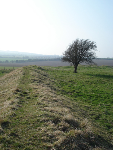
Ditch and Bank

Remains of sarsen stone at entrance

Erosion protection on the bank

Approaching the site.
Before work, I managed to sneak in a quick stroll up to the site this morning. The mist was burning off and no other soul was about so I had the place to myself (excluding a few ponies).
The site is classified as a hillfort (gentle-rise-fort doesn’t exist yet!) and was investigated as part of the hillforts of the ridgeway project in the late 1990’s.
At the start of the track leading up to the site is a large pile of field cleared sarsens and the track has the remains of a low sarsen wall running parallel to it. The views of Ashdown house are stunning.
The site itself still has lots of sarsens scattered about (remains of a wall no doubt) and you can still make out the ‘bump’ in the middle of the fort, where the Romano-British farmhouse once stood. Erosion protection is still in place on parts of the banks (much as the last time I visited a few years ago).
The view to the ridge opposite, shows three bumps of round barrows on the skyline. There is also a ploughed out barrow site on the other side of the woods. I spent a few minutes enjoying the silence and then plodded back to the car and unfortunately, back to work.
If ever you visit for the day, a tour of Ashdown house (stunning views from the top) plus visiting this site (and the sarsen field in front of Ashdown house) and maybe a picnic, would, in my humble view, be a nice day out. It’s close enough to Waylands and WHH aswell.
The “Dragon”, or “Michael” Line passes through the earthen banks and on through Ashbury House. There is a tale that the house was deliberately built on the energy line for the “good masculine energies”.
Above the Head of the River Ock, is Ashbury-park, near which is a Camp of about 100 Paces in Diameter, but the Works are almost entirely defaced, by digging for Stones to build Lord Craven‘s House in the Park, which was a very magnificent one, but was unhappily burnt down.
From The Natural History of England by Benjamin Martin (1759).
Details of Site on Pastscape
A univallate hillfort situated c500m north west of Ashdown House. The earthwork defences consist of a single rampart bank which measures between 3m and 10m wide and stands up to 1.5m high. It was originally revetted with sarsen walls. Two seasons of excavations by Oxford University have revealed Late Bronze Age origins to the site with a Roman building within the centre of the enclosure dating from the 2nd – 4th centuries AD. Attached to the north of the enclosure is an elongated annex dated to the Late Bronze Age. The site has also been surveyed and mapped from aerial photographs.
[SU 27738223] Alfred’s Castle [T.I.] CAMP [G.T.] (1)
Alfred’s Castle, Ashbury, is an earthwork of roughly hexagonal shape, consisting of bank and outer ditch enclosing 2.6 acres [see plan AO/LP/63/162] The original entrance is in the south-east corner, but it is not certain if the gaps in the north-east and north-west sides are original or not. The site has not been excavated but sherds of Southern Second A, Southern First C, Romano-British and ? Saxon pottery have been found on the surface; there are traces of a structure of some sort, possibly a building, in the interior. The position, size and shape of the work are unlike any of the Berkshire hill-forts, but are more like the type of site chosen for a farmstead or village (2). Wheeler however, includes it in his provisional map of Belgic defended sites (4). Cotton includes it in her list of Berkshire hill-forts (3) and Thomas calls it an Iron Age hill-fort (5). Allen’s air photograph [AO/LP/63/161] reveals the ditch of a much larger enclosure to the north of the camp, which may represent an Iron Age work of early date; it cannot be traced on the ground (2). Scheduled (6). Iron Age univallate hill-fort under three acres (7). (2-7)
Alfred’s Castle is a small defensive enclosure, the defence consisting of a strong rampart (with Sarsen revetting exposed in places) and a broad ditch. Of the three entrance gaps, that in the N.E. appears to be comparatively modern. There are traces of possbile building platforms within the earthwork but for the most part these are ill-defined. The large annexe visible on the Allen A.P. cannot be traced on the ground. There are numerous sherds of I.A. and R.B. pottery in molehills within Alfred’s Castle, and Newbury Museum has the following collections:-
Two Ne. sherds and a small spear or large Ne arrowhead and I.A. sherds (Acc. 1931:115). I.A and R.B. sherds (Acc. 1938:259 and 1960:16).
As Mrs. Cotton and Prof. Wheeler have suggested the site is that of a defended farmstead or village rather than a hill-fort.
Surveyed at 1/2500. (8)
Over 40 Early Iron Age and Roman sherds found on site in 1980-1. (9)
The earthwork enclosure known as Alfred’s Castle described by the previous authorities was mapped from aerial photographs. Attached to the northern side of Alfred’s Castle enclosure is an elongated annex defined by a single broad ditch measuring 150m x 320m. Within the Alfred’s Castle enclosure the foundations of a 2nd-4th Century AD Roman building were mapped from aerial photographs taken during excavations of the site in July 1998. The excavations were carried out by Oxford University as part of the Hillforts of the Ridgeway Project. This work was able to provide dating of the site from the L. Bronze Age through to the 4th Century AD. A second season of excavation at the site was carried out in July 1999 which among other findings was able to date the annex enclosure to the Late Bronze Age. To the north-west and west of Alfreds Castle the extensive cropmark remains of a system of large ditched enclosures or fields were seen and mapped from aerial photographs. These enclosures appear to be continuous with the L.Bronze Age annex enclosure to the north of Alfreds Castle. This system of enclosures have been recorded in SU28SE **. (11-13)
Report of the excavation. (14)
--------------------------------------------------------------------------------
SOURCE TEXT
--------------------------------------------------------------------------------
( 1) Ordnance Survey Map (Scale / Date) 6” 1960
( 2) Berkshire Archaeological Society The Berkshire archaeological journal 58, 1960 Page(s)44-8
( 3) Berkshire Archaeological Society The Berkshire archaeological journal 60, 1962 Page(s)51
( 4) The Antiquaries journal : journal of the Society of Antiquaries of London 7, 1933 Page(s)34
( 5) Nicholas Thomas 1960 A guide to prehistoric England Page(s)41
( 6) General reference Ancient Monuments in England and Wales 1961 (M.O.W.) Page(s)19
( 7) General reference OS Maps of Southern Britain in the Iron Age 1962 Page(s)48
( 8) Field Investigators Comments F1 JP 25-FEB-64
( 9) Oxfordshire Archaeological Unit : newsletter 8(3), 1981 Page(s)1
(10) Scheduled Monument Notification 04/03/1997
(11) Vertical aerial photograph reference number OS 72 224/151 15-JUL-1972
(12) Oblique aerial photograph reference number NMR SU2782/31 09-MAR-1989
(13) Oblique aerial photograph reference number NMR SU2782/53 JUL-1998
(14) Council for British Archaeology Group 9: South Midlands archaeology newsletter 29, 1999 Page(s)44-53
‘Alfred’s Castle, on the hill west of Ashdown, was called Ashberry Camp on a map of Shrivenham Hundred in 1532 referred to in Miller’s History of Ashbury, and it was given the alternative names of Alfred’s Castle and Ashbury Camp by Wise in 1738. There is no doubt that the original name was Ashbury Camp, and it is almost certainly the camp from which Ashbury was named, which was spelt Aescesburh in the Anglo-Saxon charters.‘
Exceprt from White Horse Hill and surrounding country by L V Grinsell
A few nice pictures (including a plaster cast of a trench) and all three reports on the digs (as part of the hillforts of the ridgeway project).
A Romano-British Farmhouse was built inside the hillfort at a later date.


