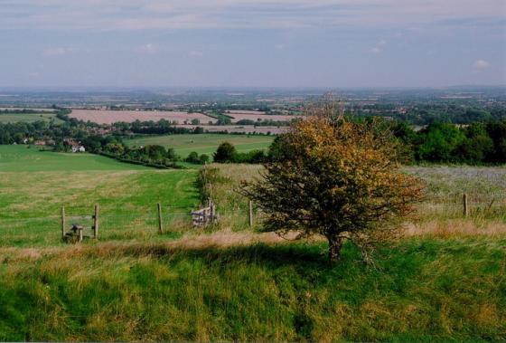
Zoom to highlight the low remains of the single rampart.
Images
The low remains of the single rampart can just be seen when viewed from the NW.
From the east there is little to indicate the presence of an enclosure.
Taken from the Ridgeway
Taken from the road to Lambourn. You can see some crop marks just below of brow of hill.
Distant shot of Rams Hill taken from near where the road crosses the ridgeway.
Articles
View from afar 13.11.11
Whilst driving north along the minor road from Lambourne 7 Barrows towards the Blowing Stone I looked over to my left towards Rams Hill. I wasn’t planning a visit and just happened to look over to see if I could see anything. I was in luck.
The crops were in and the grass low. The sun was in just the right position in the sky and I could clearly see the contour of a ditch, cast in shadow, running around the eastern slope of Rams Hill. The ditch was about a quarter of the way down the slope from the top of the hill. Had the sun not been in the position it was I probably wouldn’t have been able to see anything. As I say, I was in luck.
Rams Hill lies adjacent to the Ridgeway between blowingstone hill and white horse hill. It is very easily missed as all that remains is a prominent, but gently sloped hill.
If you look carefully, you can just (and I mean just!) make out the much eroded remains of a single bank and ditch just below the crown of the hill. The hill itself is small but sufficient to stand out in the surrounding topography.
On the OS map, Rams Hill is marked as a ‘fort’. This is slightly misleading. It is not a hillfort of the Iron age, but a neolithic structure known as a ‘causewayed camp’.
Its original use seems to have been as a meeting place for trading and possibly ceremonial purpose. Its position relative to the White Horse and Uffington castle should be noted. Also, on foot it is not far from Lambourn Seven Barrows.
At Rams Hill, on the downs about two miles north of seven barrows, part of the hilltop was at first enclosed by a bank and ditch; but around 1500BC stronger defensive ramparts were put up, with stout palisades on either side of the ditch. Recent excavations suggest that Uffington Castle may have superseded Rams Hill when a much larger and stronger encampment was needed.
Daphne Phillips
Berkshire – A County History
“The name occurs in the form hremmes byrig in a Saxon charter of A.D. 940 (Chron. Monast. Abingdon, vol. 1, p.70), and means ‘raven’s fort’.”
The Scouring of the White Horse
G. W. B. Huntingford
The Journal of the Royal Anthropological Institute of Great Britain and Ireland, Vol. 87, No. 1. (Jan. – Jun., 1957), p. 105.
What is a causewayed camp?
Unlike an iron age hillfort, where the ditch and bank runs almost completely around the fort, a causewayed camp has a ditch which is crossed many times with entrances. An iron age hill fort is for defence, a causewayed camp is not. Its prime purpose is not defensive in nature.
It was first thought that they were enclosures for cattle in the Neolithic period. Many bones from culled animals of many types were found in the ditches surrounding these structures.
It is thought that they performed a variety of social, economic and religious functions for early neolithic communities.
Sites within 20km of Rams Hill
-
Blowing Stone
photo 20 ondemand_video 1 forum 1 description 15 -
Uffington Castle Round Barrow
photo 4 description 4 -
Uffington White Horse
photo 91 ondemand_video 2 forum 29 description 41 link 10 -
Uffington Castle Long Mound
photo 1 description 4 -
Dragon Hill
photo 29 description 12 link 1 -
Uffington Castle
photo 48 ondemand_video 1 description 11 link 2 -
Idlebush Barrow
photo 2 description 4 -
Kingston Lisle Tumulus
photo 2 forum 1 description 2 -
Sparsholt Down
description 1 -
Hardwell Camp
photo 21 description 2 link 1 -
Moss Hill
description 1 -
Coin Barrow
description 1 -
Pigtrough Bottom (top of)
photo 5 description 2 -
Lambourn Long Barrow
photo 11 description 11 link 1 -
Sparsholt Down (edge of)
photo 2 description 1 -
Wayland’s Smithy
photo 138 ondemand_video 2 forum 16 description 49 link 12 -
Hackpen Hill (Oxfordshire)
photo 7 description 2 link 2 -
Lambourn Sevenbarrows
photo 36 forum 1 description 10 link 1 -
Tower Hill
description 1 -
Adstone
description 1 -
Devil’s Punchbowl
photo 6 link 1 -
Hangman’s Stone
photo 1 description 4 -
Ashdown Park Sarsens
photo 9 description 4 -
Snivelling Corner
photo 2 description 2 -
Ashbury
photo 1 description 2 link 1 -
Alfred’s Castle
photo 9 description 5 link 1 -
Fognam Clump Barrow
-
Fognam Clump Barrow
description 1 -
Ashbury Earthwork
description 1 -
Three Barrows
photo 8 description 3 -
Little Coxwell Camp
photo 13 description 2 -
Segsbury Camp
photo 22 description 6 link 2 -
East Garston Ditch
photo 10 description 2 link 2 -
Pewitt Farm Barrow
photo 6 description 3 -
Badbury Hill Camp
photo 5 forum 1 description 4 -
Woolley Downs Barrows
photo 2 description 2 -
Goddards Barn Barrow
photo 4 description 2 -
Round Hill Mound
photo 1 description 2 -
Yew Down Barrow
description 1 -
Aldbourne 7
photo 3 description 1 -
Sugar Hill
photo 9 description 1 -
Membury Camp
photo 27 description 3 link 2 -
Lord Wantage Monument Barrow
photo 1 description 3 -
Aldbourne Four Barrows
photo 11 forum 1 description 5 link 2 -
Liddington Warren Farm
photo 13 forum 1 description 3 -
Aldbourne 'Cup Barrow'
photo 1 description 1 -
Warren Farm
photo 1 description 1 -
The Aldbourne Way
description 1 -
Cherbury Camp
photo 6 forum 1 description 2 link 2 -
Midsummer Wood Barrow
description 1 -
Aldbourne Blowing Stone
photo 3 description 2 link 1 -
The Giant’s Grave (Aldbourne)
photo 20 description 1 -
Shipley Bottom
photo 3 description 1 -
Aldbourne (west of Giant’s Grave)
photo 7 description 1 -
Highworth Circles
description 1 -
Liddington Castle
photo 30 description 4 link 3 -
Ballards Copse Long Barrow
photo 3 description 1 -
Goldbury Hill
photo 1 description 2 -
Coate Stone Circle
photo 13 forum 7 description 19 link 1 -
Stanton Fitzwarren
photo 1 forum 1 description 1 link 2 -
Scutchamer Knob
photo 5 forum 2 description 14 -
Coate Mound
description 2 -
Grim’s Ditch
photo 6 description 2 -
Broome Long Stone
description 1 -
Broome Temple
description 2 -
Devil’s Footprint
description 1 -
Burderop Wood Stone Circle
description 1 -
Whitefield Farm
description 1 -
Horse and Jockey Barrows (Thorning Down)
description 1 -
Castle Hill (Broad Blunsdon)
photo 6 description 4 -
Rowbury Farm Barrow
photo 1 description 1 -
Beedon Barrow
description 3 link 1 -
Rushy Platt Bowl Barrow
photo 2 description 1 link 1 -
Hagbourne Hill
photo 2 description 4 -
Drayton
description 1 -
Borough Hill
photo 2 description 1 -
Ogbourne St Andrew Barrow
photo 15 forum 1 description 8 -
Ogbourne St Andrew Church
photo 6 description 3 -
Barbury Castle
photo 40 forum 3 description 18 link 1 -
Fox Barrow
photo 6 description 3 -
Drayton Cursus
photo 1 description 1 link 1