Previous 20 Previous 20 | Showing 21-40 of 40 fieldnotes. Most recent first
Not a visually exciting site this one. But still good to know you stand on ground that, at one time, held a special meaning. It's also strange to think that the Romans, when they were laying nearby Stane Street, probably had not the slightest clue this site was here.
The South Down's Way meets the Roman road at Bignor Hill car park. Diverting off the Way south, then south west along the Monarch's Way, takes you right through the centre of the enclosure.
On your right the south western third of the site is delineated by scrubland, presumably cleared from the interior of the site for archaeology in 1983. The treeline, therefore, marks the edge of the enclosure.
On the left, the north eastern two thirds of the site lie in an open field, and seem invisible, though it is only in this part that remains of the enclosure seem to have been recorded.
Entering the enclosure from the north west, at SU974126, one walks over a very low rise in the ground, which is the only original physical sign of the enclosure I could make out.This post appears as part of the blog post " Pilgrimage" |
What can I say about the Long Man him/herself?
At first sight, up close, it will be a disappointment, consisting, as it does, of concrete blocks painted white. For me the real delights of this site lie above him on Windover Hill, and I have added these as associated sites.
The best way to experience the Long Man, in my view, is to sit on the flat platform to his/her right, formed from the spoil of a small chalk pit, and picnic/chill/meditate/whatever takes your fancy and involves sitting there.
This is a site where I have attended many open druid rituals and it is a wonderful setting. After a while those concrete blocks begin to speak to you….This post appears as part of the blog post " Painting the Long Man" |
On the return leg of our holiday we visited the Hill of Tara, which is incredible. A complete jumble of sites, reflecting a rich history and prehistory. I cannot thank our guide enough, as he went out of his way to give us the "extra" tour after the quick version he had to give a coach party. He was clearly in love with the place.
This is a rich and extensive site that surpassed my expectations completely.
It is almost as if someone decided to move a whole jumble of ancient sites to the top of a hill that is invisible from the countryside around it.
I'll be back...This post appears as part of the blog post " Sligo and Meath" |
There is nothing to see inside the King's Seat, apart from a good view of Cormac's House.
It is not contemporary with Cormac's House and was built, I understand, in Christian times.This post appears as part of the blog post " Sligo and Meath" |
The weird figure eight formed by the proximity of the King's Seat and Cormac's House is fascinating. Within the pre-Christian Cormac's House stands the Lia Fail and a memorial gravestone to the Irish Rebellion of 1798.
Formerly a statue of St. Patrick stood here, in triumphant celebration of the defeat of the Heathens. When an attempt was made to take it away for renovation it fell apart, so a competition was held for local children to design another statue to stand by the path leading to the Hill of Tara.
Some locals disapproved of the resulting statue, due to his skirt not being long enough, so they pulled it down. A bog-standard St. Patrick now stands by the path instead, "biding his time" as a non-catholic local said to me on the Hill.
Meanwhile, Cormac's House remains Patrick free…This post appears as part of the blog post " Sligo and Meath" |
Knocknarea dominates the landscape of its peninsula gloriously. We were camping at Strandhill and by the time we had been there for 3 days I was itching to climb it.
I had read about the old tradition of taking stones from Maeve's Tomb at the top, and how the local council were trying to encourage a new tradition of ADDING stones to the tomb instead, and I was mightily tempted to carry a large stone all the way up the hill form the beach at Strandhill.
In the event my father joined me in the climb and time constraints led to our driving half the distance and then walking from the car park at the base of the steep climb up its south east side.
The path is treacherously rough, a REAL path I prefer to call it, and you really felt you had earned reaching the top. From there it is a short easy walk to Maeve's Tomb, which looks close up distressingly like…well a pile of stones. But then again I'm from a neck of the woods where we don't have that much stone to pile up, so that was probably just me.
The real interest is on top of Maeve's Tomb, where there is another small cairn. In my photo of this all the ground around it is the top of the Tomb, which is a lot grassier than one expects. From the top you can also see words spelt out in the heathland all around the Tomb with rocks from it, presumably for good luck or in remembrance of those passed. Okay, so this does involve taking stones from the Tomb, but it was very touching to see nevertheless.
We added our stones from Strandhill beach to the cairn and it felt a great honour to add to the building of an ancient site. I did my druid thing and honoured the site with a libation of water, then we enjoyed the view, which is incredible.
From Maeve's Tomb we walked northwest to the edge of Knocknarea, to look down on Strandhill where we were staying. Wonderful views.
Returning to the Tomb I went to sit on the cairn at the top again. This time I was attacked by wasps, which I took to be a message to leave!This post appears as part of the blog post " Sligo and Meath" |
A wonderfully simple stone, with the modern base seeming not to detract from its power.
From here it is easy to believe that, on a clear day, 20% of the land mass of Ireland can be seen from Tara.
I have no Irish ancestry that I know of, but as my partner is half Irish I chose this place, as a Druid, to quietly say hello to the land and formally introduce myself.
What a fantastic spot...This post appears as part of the blog post " Sligo and Meath" |
What a confusion of ditches and banks! Not really helped by the fact that the British Israelites dug it up in the early 20th century looking for the Ark of the Covenant!
This should tell you all you need to know about that particular crowd: http://www.themodernantiquarian.com/post/3418
According to a guide at Tara, one of them still turns up yearly with a shovel and a map and asks to dig a test pit. Let's hope this happens while a crowd of Modern Antiquarians are there, so we can help him to occupy it...This post appears as part of the blog post " Sligo and Meath" |
In my considered opinion this strikes me as being a cursus. But then again, perhaps I'm biased.
I walked its entire length in both directions anyway, just in case...This post appears as part of the blog post " Sligo and Meath" |
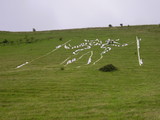
A double circle Neolithic causewayed camp.
The inner circle can just about be traced all the way around, except where the circles have been interrupted by the downland scarp to the north. A right of way crosses the site, and the double entrances at both east and west can be made out best from this.
Also to east and west, right by the entrance in the case of the latter, are impressively sized Bronze Age round barrows (Impressive for this neck of the woods at least!)
This was the last causewayed camp built on the South Downs and it is roughly contemporary with Avebury Henge, where the Windmill Hill causewayed Camp was being abandoned in favour of the newer style of sacred enclosure, indicating how "backward" the Neolithic culture this far from the plateau of Wiltshire may have been.
|
I am adding some sites on Windover Hill, the site of the Long Man of Wilmington. These photographs were taken nearly 4 years ago and I have only just dug them up!
The landscape above the Long Man is well worth a visit for those who don't mind shapes in the grass with no interesting rocks cluttering up the place. We don't really do rocks in this neck of the woods.
(See the Goldstone, in Brighton, for a notable exception. The only megalith to have had a football ground named after it!)
The fact that a large Neolithic Long Barrow and a large Bronze Age Round Barrow seem to be aligned with the space on which the Long Man now stands is something that I find intriguing. While the Naturalistic figure of the Long Man could only be Roman at the very oldest, I believe there to have been something on this site for a very long time. If only we could see what were the original designs on this hill.This post appears as part of the blog post " Windover Hill" |
A few miles West of Chanctonbury Ring, and also on the South Downs Way, this prominant ditch and bank straddles the path, and seems to be an Iron Age boundary marker, though I have been able to find little to confirm this.
To reach it head about 2 miles East, on the South Downs Way, from Amberley Train Station. In guides it can be found in the Washington to Amberley section.This post appears as part of the blog post " Pilgrimage" |
An impressively sized Round-Barrow group that meets the South Downs Way at a right angle on the Cocking to Buriton stretch.
This is quite a remote section of the Way, so you have a fairly even choice of routes and can more or less guarantee peace once at the site.
Either walk East along the Way from the Harting Hill car park for about 4 miles, the more picturesque option which also passes Beacon Hill and Pen Hill, or West from Cockinghill car park for about 3 miles, which is probably the less tiring route.
There is an information sign near the barrows.This post appears as part of the blog post " Pilgrimage" |
|
At the time of posting, the booklet I mentioned in my last fieldnote is unavailable, as the machine is......non-functional. Good to see EH keeping the facilities up to scratch!
|
Lying to the North of the New King Barrows, this group is slightly older and certainly less imposing.
The more northern barrows of the group are aligned with the Long Barrow that originally was the eastern terminus for the Cursus.
Further to the south another group have been very ploughed out over time, though they remain in clearings that give a good indication of their original size.
My photo is of one of this latter group.
|
When you next visit Stonehenge, try getting hold of the booklet "Exploring The Stonehenge Landscape" that is sold from machines in the car park, but not in the shop for some odd reason.
I recommend Walk 3, which takes in all the most prominent barrow groups to the north, but most importantly includes walking the entire length of the Stonehenge Cursus, a two mile long processional Neolithic route that leads to a now destroyed long barrow. The sides of the Cursus can be made out along most of its length and it is vast in scale.
For much of its length Stonehenge can be seen right on the horizon, without all the modern rubbish that surrounds it. The walk ends by approaching the Henge up the Stonehenge Avenue, from the exact direction of the Midsummer sunrise.
The walk is about 6 miles in total and gives you an utterly different way of seeing the whole area.This post appears as part of the blog post " Pilgrimage" |
I can understand why there are no reports for Windmill Hill as yet.
Frankly, Avebury is nearby and far more accessible and spectacular, whereas Windmill Hill is relatively unknown outside archaeological circles, a bit of a pain to get to and once you get there there isn't too much to see.
However...
It WAS the forerunner to Avebury, being of the earlier Causewayed Enclosure type that was the style of sacred circle that led to the Henge. It is also the site from which the entire Causewayed Enclosure building culture of southern Britain is named. In all the aerial photographs of it that you are likely to see, from about 1950, there has been a recent archaeological dig, so the three rings look quite prominent. When I got there one could barely make them out.
The one section of ditch that looks most spectacular is actually a more recent quarry on the north eastern side, but the rings CAN be traced, possibly more easily if the grass is cropped close, and there are two impressive Bronze Age round barrows on the top of the hill, inside the enclosure. This is typical of the later Bronze Age peoples, who seemed to see Neolithic sites as places of death, where it was auspicious to bury their chieftains.
Strangely the centre of the enclosure is not upon the top of the hill, but offset to the northwest. I like to imagine the first arrivals trying to determine where the centre should be, while the place was still forested. Being such a low hill this would not have been easy necessarily, and the centre just misses it. But who knows? Perhaps it was deliberate.
It IS a very peaceful place. The place from which those who first decided to create permanent meeting places in this landscape would have viewed the land around them as the tree cover was stripped away from the hill over the years. Sitting on the hill, looking in the direction of Avebury, it is easy to imagine a person in about 3000BC, whose name we will never know, first thinking up the idea of a more ambitious project in the shallow valley below, and the site of the future Silbury Hill is clearly visible.
You are guaranteed peace on this hill, and I look upon it as Avebury's "quiet room", as the tourist trail doesn't go near it. But it does also seem a slightly sad place for all that. As I traced the circles I felt quite sombre, yet safe and welcome there.
This was on Tuesday 16th February 1999. Immediately after walking to Windmill Hill I visited my last remaining grandparent in nearby Swindon. He unexpectedly died two weeks later, so Windmill Hill will always have a certain association for me.
To sit upon its highest point in silence, with a gentle wind sending waves through the grass around you, is to feel a real connection with a way of life and a culture that has now passed, yet which gave birth to the culture which created our best known sacred sites.
|
Previous 20 | Showing 21-40 of 40 fieldnotes. Most recent first |
I am an Atheist Naturalist Humanist Neo-Pagan Ritualist Revivalist Philosophical Druid (Yes that title is tongue-in-cheek), living and practising in Sussex.
The Long Man of Wilmington is a site of great importance for me and was the first with which I feel I connected spiritually. In 1998 I started walking extensively in the area of the Long Man as well as taking an interest in its history.
Both my grandfathers died in early 1999 (See my fieldnotes on Windmill Hill). As a way of honouring them, between April 1999 and August 2000 I walked the route from Eastbourne, in East Sussex, to The Uffington White Horse in Oxfordshire, via the South Down's Way, Winchester Cathedral, the Clarendon Way, Salisbury Cathedral, Stonehenge, Salisbury Plain, the Vale of Pewsey, Avebury and the Ridgeway.
The walk also took in visits to both of their graves, in Sussex and Wiltshire, en route.
In 2001 I extended this walk from Salisbury Cathedral, West to Wells Cathedral and then on to Glastonbury Tor.
Nearly all of my earlier pictures were taken during these walks and I tend to focus, overall, on Sussex and the South Downs.
In recent years I have also taken an interest in Ireland, as marrying into an Irish family does tend to mean one visits the place from time to time!
Although I have become an atheist, I still class myself as a Pagan. This can give rise to interesting discussions!
|