Tintagel Excavations 1998
|

Tintagel's Place in post-Roman Britain
|
A New Interpretation of the "Artognou" Stone
|
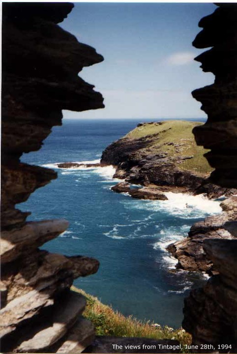
Visited 28 06 1994
Tintagel 1994 meant my 30st birthday, and much more besides that. I'm an Arthurian buff (though not necessarily a believer) and to be here at Arthur's supposed birthplace on my birthday meant a lot.
The village is too touristic to stay long (only if you want your Arthurian stuff, it's THE place to be and spend your money dearly).
Best run along to the coast and the Norman castle, and of course the peninsula beyond.
This is where the (in)famous ARTOGNOU stone was discvered, a fake to some (of course, ALL referring to Arthur must be..), proof to others (nonsense, it's a different name), very nice old stuff to me. This was a true Dark Ages site, possibly a monastery, but more likely a palace of sorts, owned by a powerful lord with control over shipping and possibly even across the Channell. Maybe not Arthur, but Arthurian for sure!
|

|
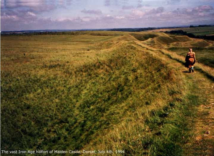
Visited 23 07 1994
What I still remember of the visit, now more than 8 years ago, is the vastness and the strong wind from the sea. The fort is the largest one in Britain, and it is hard not to see this as a large city. No wonder the Romans fought hard to take this one, it must have had a large influence on the south coast and across the Channell. Now, all that is gone and we don't know hardly anything at all about the Celtic kingdom which once existed here. The region never regained it's strenght.
|

|

|

|
     
|
 
|

|
Visited 1992 and 1994
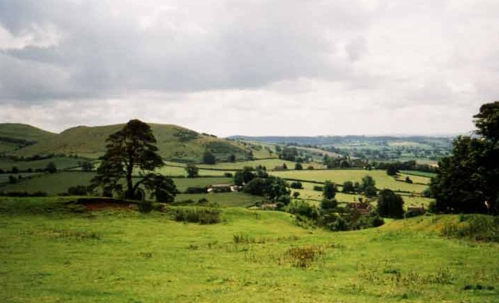
Though now ruled by cattle, once fit for a king. This Iron Age hillfort was re-occupied and refortified on a large scale during the Late Roman or sub-Roman period. No doubt about that part. As to the builder, without any written evidence we will be kept guessing. Ambrosius Aurelianus? Possibly, but can't be sure where to locate him. Arthur? No contemporary evidence available. Whoever it was, it has been proposed by experts that the massive workforce neede to strenghten Cadbury's defences can be compared to the workforce of both Wansdyke and Bokely Dyke, earthwork that are very close by.
My solution: if not Arthur, than surely a different person with the same name :-)
|
According to Pete G (a local),
"The pillar with the head is a carving by local artist Jane (Can't remember her last name) she used to live north of Avebury and had them in her garden but recently moved over to West Kennet."
About 'Little Avebury' he has this to report:
"This a natural drift of sarcens in the valley floor. On top of Thorne hill is Langdean circle. There is much debate if it is a true stone circle. Meaden ('Secret of the Avebury Stones') claims it is while Burl ('Prehistoric Avebury') thinks it is a ruined round house. I have been there before a few times and tend to think it is a circle with a cove in the middle. The smaller circle nearby is a collection of field clearance stones."
|
In the isolated Lleyn peninsula we can find a real ancient Iron Age hillfort connected to the Vortigern legends. Below the superb viewpoints from Yr Eifl (anglicised to ‘the Rivals’, but in Welsh ‘the Fork’) lies one of the most spectacular hillforts, Tre’r Ceiri. On a rocky heather-covered plateau below the eastern peak some 150 huts, that might have supported up tp 500 people, can still be seen clearly.
Locally known as the ‘Town of the Giants’, the walls are still more than 4 metres high in places - no wonder how it received its name.The hight of the walls might very well be caused by its isolation and position 457 metres above sea level, which has prevented all too much stones being looted, as was the case for so very many similar hillforts.
Many of these stones have curious holes in them, varying in size but never large ones. These holes are no mystery, they were drilled to show where the walls had been subject to a conservation project. A ten year long conservation project was carried out on Tre'r Ceiri by Gwynedd Archaeological Trust and Gwynedd Council. The drystone walls were becoming extremely fragile and erosion by the increasing numbers of visitors was causing an alarming amount of damage. The collapses in the walls were causing the masonry to loose its structural integrity. The
collapses were rebuilt in the original building style and the edges of the conserved/rebuilt masonry were marked with small drill holes.
|
Local tradition places Vortigern in Nant Gwrtheyrn (the ‘Valley of Vortigern’), a rocky valley leading down from Yr Eifl to the west coast of the Lleyn peninsula. Vortigern was supposed to have once had his headquarters there.
Here we also find his ‘city’: Castel Gwrtheyrn, once so marked on Ordnance Survey maps, but now unlocated. The best candidate for this fortress surely is Tre'r Ceiri, which lies just on the other slope of Yr Eifl, very close to the valley. His grave, Bedd Gwrtheyrn, is also to be found somewhere around here, as there are several locations bearing names familiar to us, such as Carn Fadrun, or the 'fort of Modrun' (she was a granddaughter of Vortigern) further south.
|
Tre'r Ceiri described on the Vortigern Studies website.
|
The source for this name of this valley, which is the only one in Wales named after Vortigern, is not known. Vortigern's legends do take him to north Wales (especially Snowdonia), but never to the Lleyn peninsula itself. But maybe the legend about his death did travel to this area, as there are many more places that are connected with Vortigern in the direct neighborhood.
At least until around the year 1700 a stone grave covered with a turf mound existed there, which was called Vortigern's Grave (Bedd Gwrtheyrn) by the local population. George Borrow, writing in 1862 (Wild Wales), described it as follows: "It was in a wind-beaten valley of Snowdon, near the sea, that his dead body decked in green armour had a mound of earth and stones raised over it".
|
Description of Nant Gwrtheyrn (Valley of Vortigern) on the Vortigern Studies website.
|

|

|
 
|
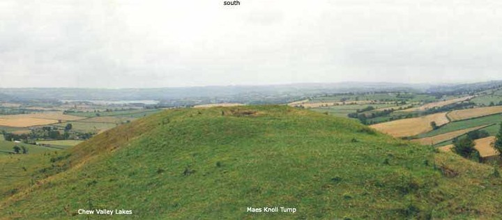
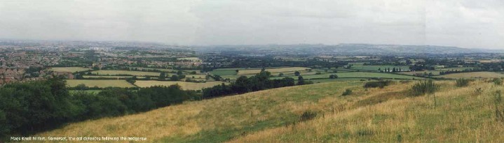
Maes Knoll described as section 1 of Wansdyke Project 21. Wansdyke Project 21 aims to support the preservation of the ancient monument known as Wansdyke by discussing all aspects of this unique Dark Ages earthwork.
|
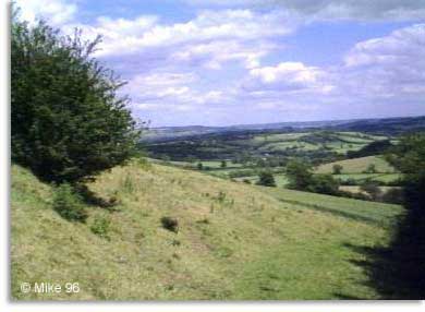
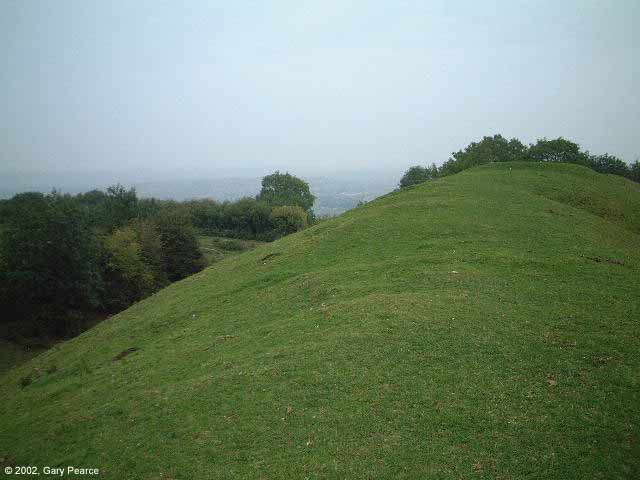
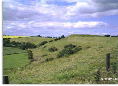
The large and very beautiful hillfort Maes Knoll lies just south of Bristol, and besides being a very beautiful hillfort, it also figures as western terminus of West Wansdyke. On the NW side there's a large earthwork, know today as 'The Tump', which blocks the access to the fort from the ridge. This may be the actual place where Wansyke starts/ends. The name 'Maes' comes from AS 'merces' meaning 'border'. Visited 1996.
Website:
http://www.wansdyke21.org.uk/wansdyke/wanwesteast/wanwest1.htm
Literature:
Tratman, E.K. (1963): Maes Knoll Camp, Dundry, Somerset, 2: The Iron Age Defences and Wansdyke, in: Proceedings of the Spalæological Society, University of Bristol 10, pp 11-15
|
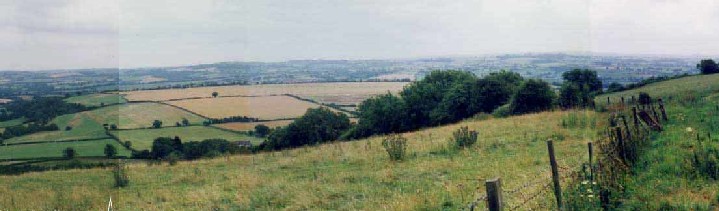
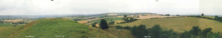
Adam's Grave, once called Wodnesbeorg (Woden's Barrow) is a Neolithic tomb dominating Walker's Hill above the Vale of Pewsey. Nearby are East Wansdyke and the Ridgeway, and two battles have been fought here that we know of. And yet, this place which must have been an ancient M1 is so very quiet today. Time heals all.
I visited during a scorching hot day, and enjoyed the views all around until I thought I would burst..
|
Though this is still England, you can forgive anyone for thinking it's Wales. In fact, this is border country. Little Doward rises high above the river Wye, just south of Goodrich Castle and Simonds Yat, which are better known places. Little Doward, however, is the one connected to Vortigern and the Dark Ages.
This hillfort above Ganarew is the foremost candidate for the elusive 'Caer Guorthegirn' (City or Fortress of Vortigern) is . Vortigern, on the run from St Germanus, fled into Wales to one of his strongholds. We know several of them, ranging from Gwynedd in the north, Dyfed in the west to this one, high above a loop of the river Wye. 'Nennius' describes it as being located in the region of Gueneri or Guenessi is probably Gwent, but the actual location is far from clear. 'Gueneri' can very well be equated with Ganarew (below).
The hillfort, which lies just to the east of the A 40 (T) a few miles north of Monmouth, is hardly accessible today. No paths lead to the summit of the hill, which is heavily wooded anyway. The OS Landranger map does show a fort, but it is very overgrown and spooky. One has a very nice view from the fort of the Wye and the surrounding countryside though.
A good view of the hill for those too daunted to attempt a visit is from the little hamlet of Ganarew, especially from the church (which is unfortunately closed most of the time). But one should take care, for leaving or rejoining the A40 can be quite hazardous due to heavy traffic.
http://www.vortigernstudies.org.uk/artcit/caerdoward.htm
|
|
I0ve been to Glastonbury three times now, and during that time I0ve seen the town change. From a depressed village with lots of beautiful sites in 1992, it changed to a booming tourist town by 1996. This was a little unfortunate (though I don't envy the jobs to the locals), because the High street changed with it to a collection of capitalist shops. Unfortunately, the prices went with it. A the small shops went alltogether, or if they were lucky, were relegated to back alleys. I hear that since that time, even the 'Gothic Image' was up for sale - shame! Anyway, the land does not change, and so the Tor, the Chalice well and the Abbey are stiil (and will always, I hope) be the same beautiful places.
|
|
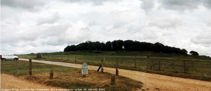
Badbury Rings is supposed to be a candidate for the Battle of Badon Hill, where Arthur decisively beat the Anglo-Saxons. However, it is no hill at all, just the remains of a settlement with earth walls and ditches around it. It was called Durnovaria during Roman times, and 4 Roman roads meet here. The views are very beautifull, I can recommend a visit to anyone .
|
Some call it simply Kit's Coty, because 'coty' means the same as 'house'. The story explaining the name tells us that Kit is Catigern, who, together with his brother Vortimer fought Hengist and his brother Horsa here around 455, which is recorded both in the Historia Brittonum as well as in the Anglo-Saxon Chronicle:.
Historia Brittonum, chapter 44
He [Vortigern] had three sons: the eldest was Vortimer, who, as we have seen, fought four times against the Saxons, and put them to flight; the second Categirn, who was slain in the same battle with Horsa...
Anglo-Saxon Chronicle for 455:
the second battle of Vortimer against the Saxons at Episford, where Catigern and Horsa fell.
Both Horsa and he were killed. We don't know who won, but Catigern was supposedly buried here. Indeed, This site is just a few miles north of Aylesford, which is usually identified with the Episford of The Anglo-Saxon Chronicle. That a battle once raged here may be supported by another reference to this place as the battle of 'Cit Coit'. This battle is also a legendary Celtic battle ('Battle of the Woods'), but not connected with any specific site. A possibility therefore remains that both are the same thing, as 'Cit' (or 'Kit') is in fact the same as 'Cat', the Celtic word for 'battle', which is of course the first part of Catigern's name.
(http://www.vortigernstudies.org.uk/artgra/kitcoit.htm)
|
|
I simply love this giant, no matter the embaresment is causes to some. And shall I tll you something, the dick's a fake! Oh yes, it is genuinely there, but the lenght was added to in later times, by 'innocently' enlarging it to incorporate the navel as well! So all theories of fertility or the abbott being ridiculed can go out of the window...
|
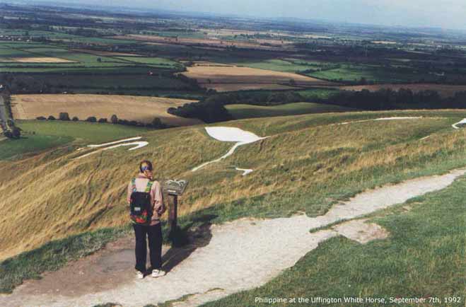
Twice I've been to the Uffington White Horse(http://www.wansdyke21.org.uk/wansdyke/wanvisit92.htm), and I will go back some more, I can tell you that! The steep valley below is called a coombe, and I've no doubt that there is a reason for Dragon Hill to be the best place to view it. Does that make the 'Horse' a dragon? Who knowns! That small hillock is dedicated to St Michael (who slew a dragon), so many say it does. Whatever, the site has everything for all kinds of theories. It's on the Ridgeway, which may have been guarded by the hillfort. It may have been a border-marker of the Celtic Atrebates tribe. It may even have been a monument to King Alfred beating the Danes around here...
The views must have been the prime reason, though..
|
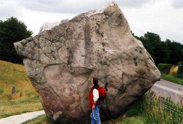
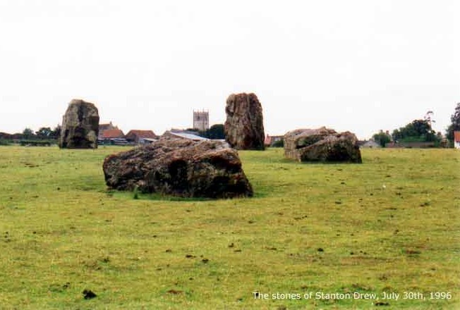
I've been 3 times to Avebury now (I'm from The Netherlands), but this site hits me all over again every time. I like it far better than Stonehenge or Stanton Drew.
(Added 13 nov 2002)
Though it's such a touristic site, there are enough times when one can be almost alone. The atmosphere here is much more peaceful. Stanton is almost desolate and Stonehenge, well, maybe I just feel out of place there, on that wide plain, as if trespassing in the cathedral of another religion. Avebury doesn't have that feling, for me at least. When they're a bit older, I'll bring the kids, too.
|
I was there 2 years ago, dragging the wife, my (then) 2-year-old and the in-laws up the hill, to get a real taste of I feel is the Right Ancient stuff. Although they were pantingand moaning, they really appreciated the site.
Does anyone know that when you walk back down to Winchcoombe, there are the remains of a hidden Roman villa just below the treeline, with a beautiful mosaic?
|
Running a website is one thing, but about a subject which is across the sea is no easy matter! My interest in the Somerset and Wiltshire earthwork called Wansdyke (http://www.wansdyke21.org.uk/) often relies on the kind help of visitors who live a lot closer to it than I do! Wansdyke Project 21 hopes to make Wansdyke better known by making all kind of information about it available through the interent (with great success, I might add). The ultimate goal is raising so much interest that any further damage can be prevented.
Born in 1964 (the year of the Dragon) in the old city of Amersfoort, The Netherlands, which is famous for its collection of single megalithic stones. I guess that's where it all started...
Today my wife Philippine and I live with our daughter Marrit (1997), our son Jeroen (2000) and our cat in the village of Houten, only a short distance from the Roman limes fortress once named Fectio/Vechten.
Maybe not surprisingly I grew up with a sense of history already present when I was very young. Books aplenty (my father had many books on local history), true historical ones but children's books as well. I guess something just had to rub off.. I still collect books 'n stuff for my growing Arthurian Collection (http://www.geocities.com/vortigernstudies/bibliograrth.htm), which I started in my childhood with the first books I read by Rosemary Sutcliff. Her 'Eagle of the Ninth' has truly set me on a course towards the enjoyment of Roman history in general and her 'Lantern Bearers' and especially 'Sword at Sunset' led me to the fascination of Sub-Roman Britain in particular. My main historical interest lies with the 5th century AD, and with the shady character named Vortigern. Infamous for letting in the English (well, alledgedly), his character has been damaged further ever since. Read more about him and the spots connected to him at Vortigern Studies (http://www.vortigernstudies.org.uk/).
Here, too, I first stumbled across Wansdyke..
Apart from my activities on the Internet I am a member of a small re-enactment group that bears the name of this fort I mentioned above, Fectio (http://www.fectio.org.uk/). Our basis is the aforementioned complicated period of those post-Roman times.
|
|