Image credit: A. Brookes (22.9.2017)

Chiaroscuro.

The silted up ditch on the north side.


The west end.

Northern flank.

The east end of the barrow, very overgrown at this time of year.


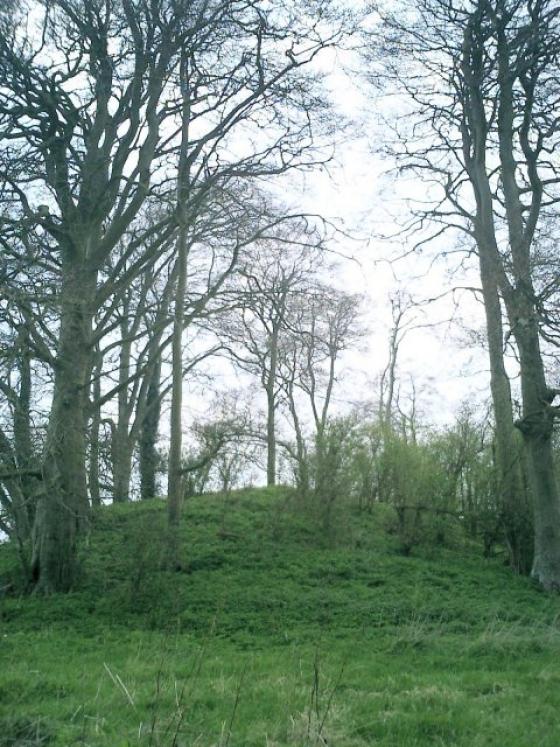
Although heavilly overgrown in high summer, the substantial form is still clear.

Note the cunning use of the Gladman rucksack to indicate some scale. So that’s where I left it, then.

Looking eastwards along the barrow....

Looking north from the eastern end of the long barrow. Bliss!

The long barrow from approx north.
Looking west (ish) from the west end of the long barrow.


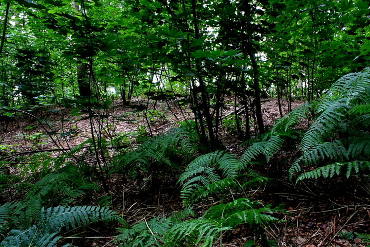
In woods marked Stone Woods Field up from the Barrow

The Barrow and Blubells, looking North
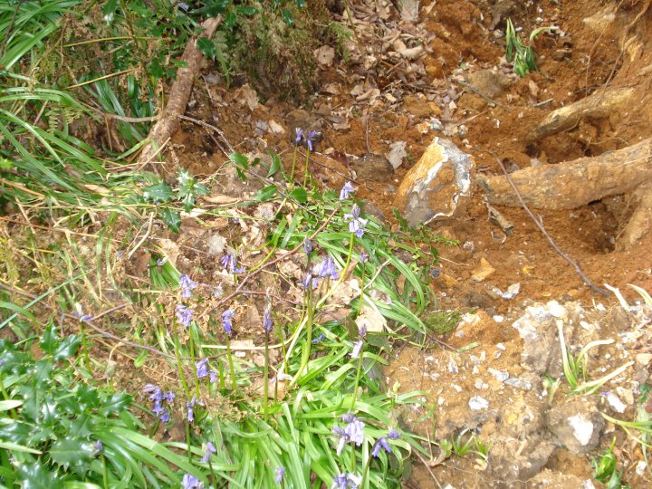
The Barrow is made up from flint deposits

The Barrows side ditch with Bluebells

The Barrow Southern side with blown over Beech tree

The Barrow has lots of new trees

The Barrow from the byway, looking North
After walking through Lockeridge Dene sarsen drift we headed up a narrow path towards Huish and into West Woods. How wonderful West Woods is at the moment – the bluebells are almost fully out so a haze of blue to be seen in almost all directions.
A more or less straight path across the wood to Hurley Bottom then onto Strawberry Ground (wild strawberries flourishing here). Turning left, follow the outer path, the Wansdyke also runs along this part of West Wood. And there is the long barrow – today covered in bluebells and dappled sunlight. Magical!
Heading north on the A345 beyond the village of Oare, a minor road veers leftwards just before the right hand turning to Clench Common. This passes Park Farm before swinging abruptly right to skirt the eastern flank of West Woods, the original line continuing as a rough byway, clearly much beloved by ‘armchair rambler’ owners of 4x4s. Woah, too tough for me, boys.....
Parking up a little along the road, I set off – on foot, since the poor old rover wouldn’t get 10 yards – keeping left at a multiple junction of tracks/paths some way along the byway. A short distance beyond, a tree covered mound materialises through the foliage to my right. Bloody ‘ell. Should have brought Harrison Ford along... he might have got some much needed plot tips for the next Indiana Jones movie, who knows?
Brambles grab at my ankles and snag the knees of my trousers as I force my way through some heavy duty vegetation and fallen branch to ascend the mound. Is this the long barrow? Reckon so... why it’s even got two flanking quarry ditches. Yeah, I’m convinced. Pretty substantial height, too. Now for the serious business of... simply hanging out upon this primeval monument as the early morning cloud cover gives way to washes of sunlight. Can there be many better places to be on a Sunday morning than upon a long barrow beneath sun-dappled foliage? With just bird song momentarily competing with an occasional mountain biker or 4x4 muppet? Guess it depends on your point of view. Sure, a winter visit would probably be more beneficial to the study of monument form and profile, but for sheer vibe? Guess there’s only one way to answer that........
Field Notes
Barrow Copse Long Barrow, West Woods – April 20th 2008
Ordnance Survey Explorer Map 157 – Scale 1:25000
Marlborough and Savernake Forest Avebury and Devizes
ISBN 978-0-319-23611-6
I first visited this long barrow back in 1988 when we were updating the County’s SMR records. It lies on the edge of a wood or collection of separate pieces of woodland called West Woods. The area was once part of the Savernake Forest, but is now owned by the Forestry Commission.
West Woods is designated access land under the Countryside and Rights of way act 2000. See www.countrysideaccess.go.uk for all the details of these rights.
West Woods is well sign posted and has two car parks, one with a picnic area at SU 16250 66703. This is nearer to the long barrow when you travel up from the A4 and Clatford Bottom. The northern car park at SU 13257 66323, is at the top of the road from Lockerage Dean. If you park here, be prepared for a long, uphill walk into the western side of the wood and along the Wansdyke. This area of the woods has some of the oldest trees, particularly Oaks. When you reach the point that the Wansdyke turns directly into the woods, follow the track to the right and keep to the edge of the wood. The barrow lies just off the track, on the left.
When we visited back in 1988, we came along the track via the byway from Clatford Bottom, which skirts the southern edge of West Woods and the Wansdyke. The barrow seemed to have more oak trees growing over it back then, but little else seems changed. Although it stands on a slight rise, the features of this barrow are difficult to discern, for it is covered both by trees and by a carpet of bluebells.
Both the Ordnance Survey in 1815, (2-inch map) and Colt Hoare in 1821 (map of Marlborough station) depict it as a round barrow. A.C. Smith in 1885 and Goddard in 1913 recorded it as a ‘bowl-shaped’ barrow but it was not until 1923 the A.D. Passmore finally recognized it as a short long barrow, oriented E-W. He gives it dimensions as Length l20 ft, width 66 ft, and 10ft. high. The side ditches, which do not continue round the ends, were then 4ft. deep and 18ft. wide.
The disturbance resulting from the excavation of Sir Henry Meux in about 1880 is still evident; at the top centre of the barrow there is a small depression with a shallow cutting leading from this to the N edge of the mound. A.D. Passmore spoke to Mr. S. Hilliard, the chief woodman, who told him Meux employee six men (of whom he was one) to open the mound.
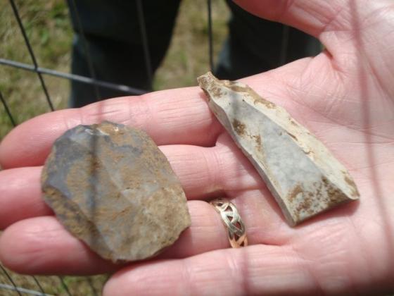
A trench was cut from the south side into what was thought to be the centre of the tumulus. At this point a small cairn of small sarsen stones was reached. In the centre of this was a dolmen consisting of four upright stones (the spaces between which were packed with large flints) and a capstone covering them, all of sarsen. The large top stone was levered off, as much as the six men could move and the inside was found to contain certain black matter, Mr. Hilliard was unable to say of what nature. He did not see any bones or pottery. The inside of the dolmen was about 6ft. by 3ft., its longer axis coinciding with that of the barrow. As it contained no relics it was left undisturbed, with the capstone replaced in its old position, and the excavation filled in.
When we examined the barrow, it was recorded as 38.0 m long with a maximum width of 30.0 m; being slightly higher at the E end, where it reaches 3.3 m. Well-defined but heavily silted ditches (9.0 m wide, 1.1m deep) flank both sides, and a ditch at the E end (0.5 m deep) is separated from the side-ditches by narrow causeways.
As the barrow has never been properly excavated, further detailed is examination is required to determine whether the central megalithic chamber, perhaps with intact tilling, is the only one within the mound, and whether it ever had a passage allowing repeated access. Side chambers may also have been constructed and lie undisturbed. Passmore muses that although exhibiting features which proclaim it to be a long barrow, this mound may, perhaps, more truly be called an oval mound of a transitional period, the stone chamber in the middle being unusual.
The centre of this 40m long barrow was dug into by antiquarians in 1880, where they found a chamber containing ‘certain black matter’ (though no mention of any bones). Could it, like Beckhampton long barrow perhaps was, be symbolic rather than a tomb?
(Burl: Prehistoric Avebury, p102)
A beautiful panorama around the barrow, taken in the Spring and showing the fantastic bluebells in the wood.