|
|

|
|
Three Shire Stones (Reconstruction)Burial Chamber
|
||||||||||||||||||||||||
|
|
|
Images (click to view fullsize) |
|
Photographs: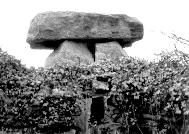
 Artistic / Interpretive:
|
Fieldnotes |
|
|
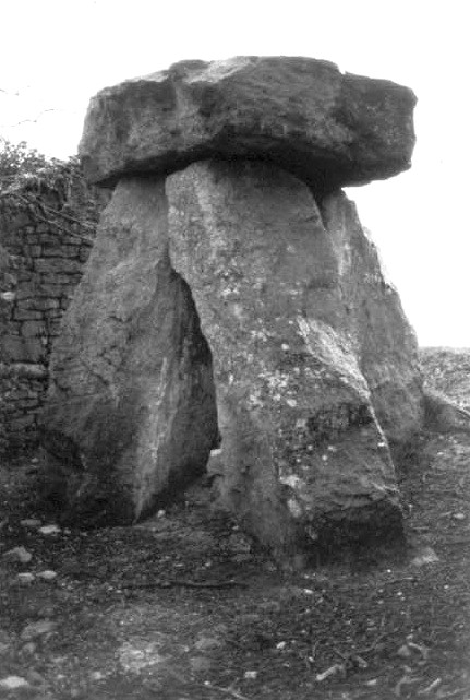
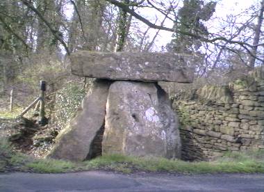
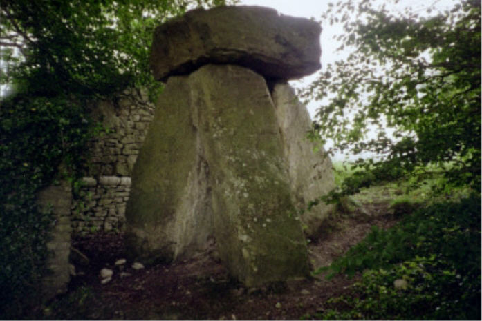
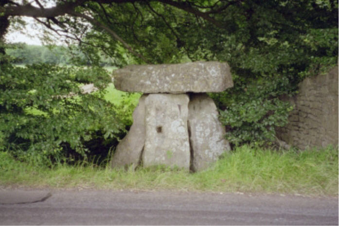
Three Shire Stones Visited 17.4.11 After spending a very enjoyable day in the picturesque village of Lacock (well worth a visit) we just had time to visit the 3 Shire Stones on the way home. Despite what I had read about the site I have wanted to pay a visit for a number of years. We drove past the stones the first time and only spotted them on the second run. If travelling south along the Fosse Way you will pass an airfield on your left and a bit beyond that a long stone wall on your right (one of those stone walls which define the boundary of a country estate). The stones are sited at the corner where the wall turns away from the road. There is nowhere to park next to the stones but there is a field gate you can pull alongside about a 100 yards further south – on the same side of the road as the stones. The 3 stones are about 2 metres high and 1 metre across. The capstone is of a similar size although more rectangular in shape. There is also a reconstructed cist in the centre of the stones made up of 4 stones. There was evidence of quite a lot of graffiti carved into the stones (including the capstone) but I am pleased to report very little litter to be seen. An odd thing I noticed was what appeared to by 3 'steps' carved into one of the uprights which made climbing on top of the capstone very easy. Prehistoric? – I doubt it!!! |
Posted by CARL 18th April 2011ce |
|
I was born in Colerne, the nearest village to the Three Shire Stones, so I know these stones well as a modern monument to mark the point where three shire counties meet - Wiltshire, Gloucestershire, and Somersetshire. Colerne was spelt ‘Cullerne’ in the Doomsday Book, hence the few genuine Colerne survivors pronounce it ‘Cullern’ whereas the Bath-ites pronounce it ‘Col-arne’. Excuse my bitterness but I am annoyed that there is no way I can afford to live in the village where my heritage comes from (‘Bull’ is one of the traditional Colerne names). Anyway enough of my soapbox, I hadn’t thought much about the Three Shire Stones possibly being based on an ancient monument until I read the ‘History of Colerne’ (no author) which says the stones are recorded as a burial chamber on an OS map of Neolithic Wessex and that a tentative date may be given of 2,000 BC. I have nothing else to back this up but will start looking. It is not included in Dr Glyn Daniel’s book, “The Prehistoric Chambered Tombs of England and Wales". The present stones are certainly modern, apparently erected by public subscription in the Victorian era, and the 'History of Colerne' says it superseded three smaller stones which were allowed to remain undisturbed beneath the central slab. |
 Posted by pure joy
12th February 2003ce |
| If you blink you'll miss it.This is a strange place,almost like it should not be here.As Rhiannon says it is rather dirty,lots of blown rubbish. |
 Posted by hamish
6th October 2002ce |
| This is a reconstruction of a burial chamber, apparently done in 1736. It's the spot where the historic boundaries of Somerset, Gloucestershire and Wiltshire meet - perhaps those boundaries really were centred on whatever these stones used to be: presumably a longbarrow. Now there are 3 blocks of limestone supporting a huge (well, relatively) capstone, but overall the feeling is small and cosy. The monument sits right next to the road - the roman Fosse Way - but it was only on my third drive-by that I actually spotted the thing. It sits nestled back, next to a wall. I sat underneath it for ages, it's very quiet and protective feeling - perhaps the only original stones are the ones underneath that you can sit on. As usual at such places there was litter everywhere - this despite it being apparently miles out, and not all of it could have blown in from the road. Rather fortunately some of the rubbish was plastic bags, so I collected two whole bagfuls and took them back to the car. People eh. It is bound to be the haunt of pissed teenagers but I wonder what they think they're sitting under. It's a strange spot because it doesn't feel quite authentic and you can't really tell whether anything is original or not. But it's different. |
 Posted by Rhiannon
24th May 2002ce Edited 4th May 2005ce |
Folklore |
|
| The stones are just off the Bannerdown road (‘Holy Hill’), where tradition has it that St.Augustine met the British Bishops. This road is part of the Fosseway Roman road. |
Posted by pure joy 12th February 2003ce |
Miscellaneous |
|
|
'The Shire Stones' are marked on John Speed's 1610 map of Gloucestershire and three stones are clearly marked. They appear to be a little to the north by the junction with the Fosse and the road to Cold Ashton, and widely spaced, separated by the roads, although this might be artistic licence on the part of Speed. Nevertheless, there were certainly three marker stones there over a century before 1736. Either those engraved with 1736 are the stones that were there in 1610, or they replaced those stones. Digital copy of the map here: https://upload.wikimedia.org/wikipedia/commons/1/1c/John_Speed_-_Map_of_Gloucestershire_-_1610_-_001.jpg |
Posted by swallowhead 29th January 2024ce |
|
Details of site on Pastscape A sham megalith, built 1859-9 as boundary marker [ST 79607002] Three Shire Stones [TI]. (1) The Three Shire Stones form a conspicuous sham-megalith of three rough-hewn oolite slabs supporting a large cap-stone and built round an earlier group of small dressed stones each of which is inscribed with the date 1736 and the initial letter of the appropriate county. A number of authorities (bibliography given) have suggested that the present structure incorporates re-used stones from some ruined chambered tomb in the vicinity. However, a printed circular, dated 1858 (a) appeals for money to assist in the completion of the 'Cromlech' ad describes how the junction of the three counties had been previously marked by ordinary 'mere-stones' and the new stones, quarried for the purpose, had been set up over the old stones. In digging the hole for the upright stone on the Gloucestershire side three skeletons and a coin of James II were found. The project was completed in February, 1859. (2) The megalith is an entirely modern feature. (3) |
 Posted by Chance
14th October 2012ce |
|
This information comes from 'The Date of the Three Shire Stones near Batheaston' by AJH Gunstone, p210 in the Trans Brist/Glouc Arch Soc v82 (1963): 'Most field archaeologists who have studied the site in recent years have suggested' that the megalith was built in the early 18th century reusing stones from some ruined chambered tomb in the district, possibly the one drawn and described by Aubrey in the mid 17th century (see TBGAS 79 p1/18 for a sketch). There are three small dressed stones inside, each dated 1736 and with the initial of one of the three counties. "Completion of the project in February 1859 was given wide publicity in local newspapers and national journals and these reports added that in the hole excavated for the upright stone on the Gloucestershire side three skeletons and a coin of James II were found." And here is part of a letter referring to the newly spruced up monument: Bath. Nov 17th 1858.The total cost was £34 5s and 8d. I thought it was rather nice that "Dinner to the Workmen" was listed as one of the expenses. |
Posted by Rhiannon 4th December 2006ce Edited 4th December 2006ce |