The Modern Antiquarian
Log in
|
Register
Home
Latest Posts
Forums
Maps
Help
Browse Sites
News
Blog
Contributors
The Books
Select
-
Belgium
Denmark
Eire
France
Germany
Greece
Italy
The Netherlands
Norway
Portugal
Republic of Malta
Spain
Sweden
Switzerland
United Kingdom
England
Northern England
Derbyshire
Wirksworth
Wirksworth II (site)
Standing Stone / Menhir
Wirksworth II (site) (Wirksworth East) (Standing Stone / Menhir) on The Modern Antiquarian, the UK & Ireland's most popular megalithic community website. 2 images, 1 fieldnote, plus information on many more ancient sites nearby and across the UK & Ireland.
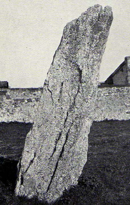
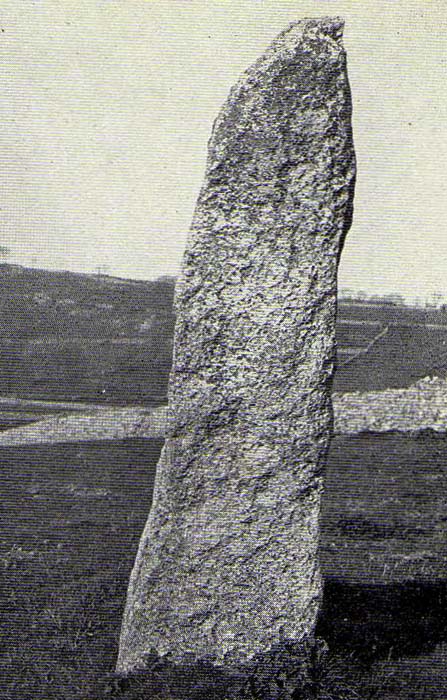
Image © Derbyshire Archaeological Journal
Also known as:
Wirksworth East
Nearest Town:
Wirksworth (1km E)
OS Ref (GB):
SK276543 /
Sheet: 119
Latitude:
53° 5' 5.37" N
Longitude:
1° 35' 16.4" W
Added by
stubob
Images (2)
Fieldnotes (1)
0 discussions
Start a topic
Show |
Hide
Web searches for Wirksworth II (site)
Flickr
Google
Google Images
MAGIC
The Megalithic Portal
Bing
Stone Pages
Streetmap.co.uk
Wikipedia
Show map
(inline Google Map)
- Sites within 20 km -
-
Wirksworth I (0.2km W) (16 posts)
Wirksworth III (0.2km S) (4 posts)
Gallows Knoll (1.14km W) (3 posts)
Ivet Low (1.69km W) (2 posts)
Middleton Moor (1.84km WNW) (3 posts)
Carsington Pasture's Cave (3.29km WSW) (4 posts)
Harboro' Rocks (3.53km W) (37 posts)
Round Low (3.74km W) (4 posts)
Ows Low (4.07km WSW) (1 post)
Hognaston Barrow (4.24km SW) (2 posts)
Moot Low (4.29km W) (2 posts)
Masson Hill (4.41km N) (5 posts)
The Stoup (4.77km WSW) (11 posts)
Rains Cave (5.08km W) (6 posts)
Hirst Stones (site) (5.19km NE) (7 posts)
Slipper Low II (5.67km W) (1 post)
Rainster Rocks (5.69km W) (6 posts)
Green Low (5.73km WNW) (26 posts)
Green Low Barrow (5.93km WNW) (7 posts)
Slipper Low (6.07km W) (2 posts)
Galley Low (6.15km W) (6 posts)
Bonsall Lane (6.25km NW) (3 posts)
Bank Top (6.52km WSW) (1 post)
Bank Top Oval Barrow (6.52km WSW) (1 post)
Blackstones Low (6.67km W) (4 posts)
Gallows Low Lane (6.69km W) (3 posts)
Stoney Low (6.76km W) (4 posts)
Bradbourne (6.8km WSW) (15 posts)
Rockhurst (6.91km W) (2 posts)
Lime Kiln Barrow (7.18km W) (2 posts)
Wishing Stone (7.2km NNE) (4 posts)
Daisy Bank (7.28km W) (1 post)
Minninglow (7.32km W) (74 posts)
Minninglow Round Barrow (7.32km W) (9 posts)
Powder Barrow (7.6km W) (3 posts)
Wigber Low (7.74km WSW) (19 posts)
Roystone Valley (7.76km W) (0 posts)
Roystone Grange (7.89km W) (0 posts)
Elton Common (8.08km WNW) (12 posts)
Roystone Rocks (8.26km W) (5 posts)
Cuckoo Stone (8.75km NNE) (5 posts)
Heart Stone (8.78km NW) (3 posts)
Gotham Grange Barrow (8.79km W) (3 posts)
Rowtor Rocks (8.8km NW) (91 posts)
Gorse Stone (8.94km NW) (13 posts)
Stanton Moor South (8.97km NW) (22 posts)
T44,45 & 46 (8.97km NW) (2 posts)
T2 cairn (8.97km NW) (15 posts)
Farley Moor (9km NNE) (14 posts)
Cork Stone (9.07km NW) (35 posts)
T25 cairn (9.15km NW) (9 posts)
T37 cairn (9.18km NW) (3 posts)
T55 cairn (9.25km NW) (6 posts)
Cat Stone (9.28km NW) (6 posts)
Dudwood (9.28km WNW) (6 posts)
Doll Tor (9.3km NW) (94 posts)
Stanton Moor Central (9.32km NW) (28 posts)
Tower Cairn (9.33km NW) (8 posts)
Hole Stone (site) (9.34km NE) (1 post)
Doll Tor Standing Stone (9.34km NW) (10 posts)
The Andle Stone (9.36km NW) (41 posts)
Bradley Tor (9.42km WNW) (13 posts)
Cratcliff Rocks (Defended Settlements and Cave) (9.47km WNW) (27 posts)
Nine Ladies of Stanton Moor (9.58km NW) (166 posts)
Robin Hood's Stride (9.58km WNW) (88 posts)
Nine Stones Close standing stone (9.64km WNW) (12 posts)
Dudwood Tor (9.67km WNW) (8 posts)
Nine Stones Close (9.73km WNW) (144 posts)
Stanton Moor North (9.74km NW) (28 posts)
Harthill Moor Barrow (9.86km WNW) (2 posts)
Nine Stones Close cup marked stone (9.9km NW) (7 posts)
Borther Low II (9.99km WNW) (0 posts)
Castle Ring (Harthill) (10.11km WNW) (22 posts)
Sanctuary Wood (10.12km NW) (3 posts)
Seven Brideron (site) (10.14km NNE) (3 posts)
Darley Dale (10.19km NNW) (9 posts)
Turning Stone and Robin Hoods Mark (10.19km NE) (14 posts)
Borther Low (10.21km WNW) (1 post)
Gratton Moor (10.29km W) (3 posts)
Basset Wood (10.37km WSW) (2 posts)
Crake Low (10.4km WSW) (1 post)
Boars Low (10.81km WSW) (13 posts)
Hawks Low (10.83km W) (0 posts)
Long Dale (11.07km WNW) (3 posts)
Gorsey Low (11.22km WSW) (1 post)
Larks Low (11.23km WNW) (5 posts)
Smerrill Moor (11.24km WNW) (3 posts)
Aleck Low (11.37km W) (10 posts)
Cross Low (11.42km W) (4 posts)
Ashover (11.44km NE) (19 posts)
Sharp Low (11.56km WSW) (4 posts)
Long Gallery Plantation (11.57km WNW) (1 post)
Bumper Castle (11.59km N) (2 posts)
The Lowe (11.72km W) (1 post)
Kenslow Knoll (11.78km WNW) (8 posts)
New Inns (11.87km W) (1 post)
Moat Low (12.06km WSW) (4 posts)
Raven Tor (12.19km N) (3 posts)
Ringham Low (Friden) (12.29km WNW) (1 post)
Eaton Dale Wood (12.31km W) (4 posts)
Friden Hollow (12.34km WNW) (2 posts)
Faybrick (12.37km NE) (6 posts)
Nettly Knowe (12.39km W) (1 post)
Raven Tor Triple Cairn (12.39km N) (28 posts)
Bostern Grange (12.5km WSW) (1 post)
Green Low Field Tumulus (12.51km W) (3 posts)
Haddon Fields South (12.61km NW) (1 post)
Liffs Low (12.72km W) (5 posts)
Fallinge Edge (12.95km N) (2 posts)
Conksbury (13.07km WNW) (5 posts)
Fallinge Edge (13.11km N) (1 post)
Reynard's Kitchen (13.16km WSW) (5 posts)
Osmaston Fields 2 (13.28km SW) (3 posts)
Beeley North (South 2) (13.32km N) (7 posts)
Beeley South (South I) (13.32km N) (3 posts)
Haddon Fields North (13.35km NW) (2 posts)
Bee Low (13.42km WNW) (3 posts)
End Low (13.47km W) (6 posts)
Tinker's Inn (13.48km SW) (2 posts)
Harewood Moor (13.54km N) (1 post)
Osmaston Fields (13.72km SW) (4 posts)
Cranes Fort (13.74km WNW) (6 posts)
Stanshope Pasture (13.77km WSW) (2 posts)
Beeley Warren (13.91km N) (5 posts)
Harland Edge SW (b) (13.93km N) (1 post)
Harland Edge SE (13.99km N) (3 posts)
Harland Edge SW (a) (14.01km N) (1 post)
Beeley Moor (14.09km N) (8 posts)
Beeley Central (14.11km N) (6 posts)
Harland Edge (14.16km N) (10 posts)
Park Gate Stone Circle (14.19km N) (48 posts)
Beeley Warren NW (14.39km N) (2 posts)
Wolfscote Hill (14.42km W) (2 posts)
Harland Edge Cairn (14.44km N) (1 post)
Calling Low Dale (14.45km WNW) (6 posts)
Harland Edge cup marked rock (14.48km N) (4 posts)
Beeley Warren ?? (14.49km N) (3 posts)
Moneystone Barrows (14.52km W) (3 posts)
Mayfield (14.54km WSW) (1 post)
Longside Moor (14.56km NNE) (2 posts)
Beeley Warren NE (14.59km N) (1 post)
Grind Low (14.59km NW) (1 post)
Gratton Hill (14.62km W) (2 posts)
Calton Pastures (14.64km NW) (13 posts)
Pea Low (14.7km W) (17 posts)
One Ash (14.83km WNW) (2 posts)
Cales Farm SW (14.86km WNW) (4 posts)
Gib Hill east (14.88km WNW) (12 posts)
Arbor Low (14.89km WNW) (205 posts)
Gib Hill (14.91km WNW) (43 posts)
Hob Hurst's House (14.93km N) (38 posts)
Lean Low (14.97km W) (10 posts)
Holymoorside (14.97km NNE) (8 posts)
Bunkers Hill Plantation (15.01km N) (5 posts)
Frank I' Th' Rocks (15.02km W) (5 posts)
Lindup Low (15.03km NNW) (3 posts)
Burton Moor (15.03km NW) (2 posts)
Margery Bower (15.05km SW) (4 posts)
Cales Dale Upper (15.11km WNW) (2 posts)
Swinscoe (15.31km WSW) (1 post)
Chatsworth Park (15.33km NNW) (3 posts)
One Ash (15.34km WNW) (1 post)
Steep Low (15.34km W) (2 posts)
Long Low (15.35km WSW) (25 posts)
Gibbet Moor Standing Stones (15.43km N) (9 posts)
Top Low and Net Low (15.47km WSW) (7 posts)
Narrowdale Hill (15.52km W) (5 posts)
Ball Cross (15.54km NW) (13 posts)
One Ash Shelter (15.55km WNW) (3 posts)
Benty Grange (15.63km WNW) (2 posts)
Hazelton Clump (15.69km WSW) (3 posts)
Parsley Hay (15.82km W) (4 posts)
Rod Knoll (15.85km N) (0 posts)
Gibbet Moor South (15.9km N) (4 posts)
Ringham Low (16.12km WNW) (5 posts)
Gibbet Moor West (16.19km N) (3 posts)
Musden Low (16.2km WSW) (4 posts)
Cheshire Wood Cave (16.27km WSW) (4 posts)
Gibbet Moor and East Moor (16.31km N) (10 posts)
Handley Bottom (16.33km NNW) (2 posts)
Bole Hill (16.34km WNW) (0 posts)
Musden Low (South) (16.35km WSW) (2 posts)
Wetton Low (16.35km W) (3 posts)
Dun Low (16.36km WSW) (4 posts)
Wetton Hill Cairns East (16.42km W) (11 posts)
Carder Low (16.43km W) (3 posts)
Musden Low (West) (16.46km WSW) (1 post)
Dalebrook (16.46km N) (4 posts)
Gibbet Moor North (16.49km N) (24 posts)
Gibbet Moor cist (16.5km N) (5 posts)
Vincent Knoll (16.62km W) (2 posts)
Calton (16.84km WSW) (3 posts)
Beeston Tor Cave (16.88km WSW) (3 posts)
Stump Cross Field Barrow (16.91km NW) (5 posts)
St Bertram's (16.94km WSW) (3 posts)
Gibbet Moor West (16.99km N) (1 post)
Gibbet Alignment (17.11km N) (13 posts)
Falcon Low (17.18km WSW) (2 posts)
Dobb Edge (17.2km NNW) (10 posts)
Wetton Hill (17.25km W) (2 posts)
Stone Low (17.36km N) (3 posts)
Crackendale Pasture (17.51km NW) (5 posts)
Sycamore Cave (17.55km W) (5 posts)
Old Hannah's Hole (17.6km W) (2 posts)
Seven Ways Cave (17.75km W) (12 posts)
Thor's Fissure Cavern (17.75km W) (6 posts)
Thor's Cave (17.75km W) (36 posts)
Dafar Ridge Cave (17.81km W) (2 posts)
Thorswood (17.82km WSW) (4 posts)
Elderbush Cave (17.85km W) (13 posts)
The Boxes (17.86km SW) (2 posts)
Newbridge Farm (17.9km N) (3 posts)
Wetton Mill Upper Cave (17.91km W) (1 post)
Over Low (17.92km WSW) (2 posts)
Wetton Mill Farm Fissure (17.93km W) (0 posts)
Stanton Dale Barrows (17.98km WSW) (3 posts)
Birchen Edge South (17.99km N) (1 post)
Mill Pot & Cave (18.02km W) (0 posts)
Calwich Low (18.03km SW) (1 post)
Ossum's Crag Cave (18.09km W) (2 posts)
Nan Tor (18.13km W) (4 posts)
Pilsbury (18.21km W) (6 posts)
Hanging Bank, Ecton Hill (18.26km W) (5 posts)
Gardom's Ring Cairn (18.28km NNW) (12 posts)
Roylow (18.38km W) (1 post)
The Three Men of Gardoms (18.49km NNW) (15 posts)
Gardom's Enclosure (18.58km NNW) (22 posts)
Gardoms Pit Alignment (18.58km NNW) (4 posts)
Warslow (18.59km W) (2 posts)
Gardom's Edge (18.68km NNW) (31 posts)
Pillsbury Hills Castle (18.73km W) (3 posts)
Gardoms Standing Stone (18.88km NNW) (28 posts)
Brund Low (18.89km W) (3 posts)
Gardom's Edge II (18.98km N) (8 posts)
Waggon Low (19.01km W) (0 posts)
Waterfall Low (19.04km WSW) (8 posts)
Birchen Edge North (19.1km N) (2 posts)
Weaver Hills (19.14km WSW) (12 posts)
Town Low (19.23km W) (1 post)
Blake Low (19.31km W) (1 post)
Grub Low (19.51km WSW) (3 posts)
Eagle Stone (19.6km NNW) (11 posts)
Hob's House (19.61km NW) (11 posts)
Fin Cop (19.66km NW) (30 posts)
Old Woman's House (19.85km WNW) (2 posts)
- Facilities within 20 km -
-
Shining Cliff YHA (Youth Hostel: 5.9 km ESE)
Matlock YHA (Youth Hostel: 6.6 km N)
The Red Lion (Pub: 8.6 km NW)
The Druid Inn (Pub: 8.8 km NW)
Barn Farm (Camping Site: 8.8 km NW)
Youlgreave YHA (Youth Hostel: 12 km NW)
Bakewell YHA (Youth Hostel: 15.1 km NW)
Hartington YHA (Youth Hostel: 15.6 km WNW)
Derby Museum & Art Gal... (Museum: 19.5 km SE)
Chesterfield Library (Library: 19.7 km NNE)
- Add -
-
Add news
Add an image
Add fieldnotes
Add folklore
Add miscellaneous
Add a link
-
Add a site
Add a nearby facility
Add an alternative name/spelling
Images
(click to view fullsize)
Add an image
Fieldnotes
Add fieldnotes
I have been told this stone is everything from fallen, moved to a hedge, used a gatepost and only a stump remains. I recently found a photo of the stone from 1919 so its time to search the hedgerows.
Comments (0)
|
Add a comment
|
Permalink
Posted by
stubob
11th September 2002ce