|
|

|
sals’s TMA Blog |
|
Malta Day Trip
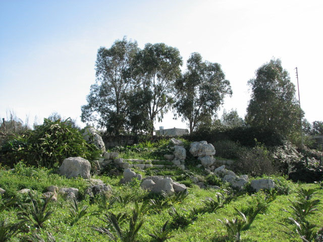
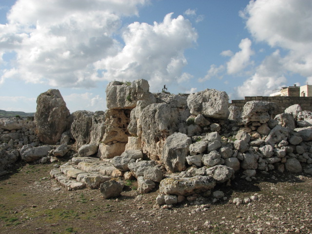
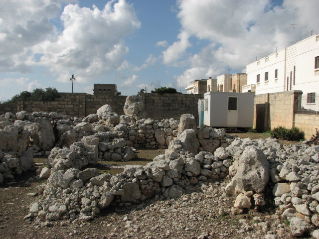
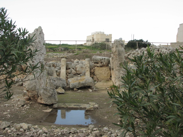
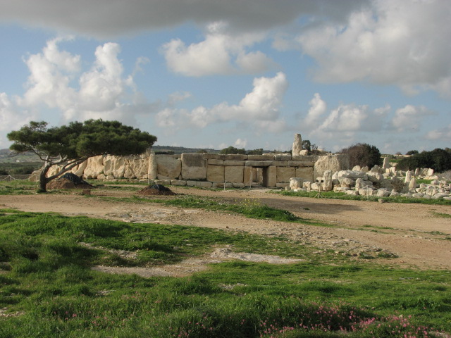
| After torrential rain over night, it was with some trepidation that I drew back my hotel room curtains on the day I'd booked a hire car - and gazed out over the city and a glorious rainbow greeted me. Going to be a good day then! Heading north from my base in Sliema, I got lost looking for a petrol station, but eventually found one, and the main road, and headed up the coast with a plan to see if I could find the dolmens at Ta' Hammud but when I saw the limestone outcrop at the turning (about 1km north of the water park, signposted Naxxar), and without an exact location to head for, or my GPS, I decided to continue on towards Bugibba and maybe come back later if time allowed. I wasn't planning to head into any urban areas, leaving the temple at Bugibba for a bus trip later in the week, instead I was heading for Tal-Qadi. In TME, the introduction to Malta says that only the stone remains, but I'd found other references to the temple itself online, and despite it being marked in two different places on my map (pub Berndston, scale 1:45 000, cost just over 2 euros from a stationers by the ferries in Sliema and widely available) I figured I could find it. I knew I had to turn south before Bugibba and Qwara, so did so, on a road signposted to Naxxar - but soon worked out I'd turned too early. So pulled one of the many u turns of the day and headed back to the junction and along to the next main turn. I reached the village of Bur Marrad and realised I still wasn't on the right road (normally Beardy navigates, and it's a lot easier him in charge of directions, rather than looking at a map and research notes spread out on the passenger seat) so headed down a side street to the left. A very bumpy and very flooded side street, which went past a poultry factory and a boat yard, and came out back on the first road I'd turned down. Bugger! Sure enough, the flooded track between the two turnings I'd already tried was the one, and it took me through yet more standing water and round potholes galore, past a tiny church, and taking the left fork, I pulled up just after the poly tunnels of a nursery - Plant Supplier Ltd - and checked my notes. Getting out of the car with a sheaf of paper and a camera, a local man approached me and asked if I needed anything - and pointed me back a handful of yards to the path up to the temple. Tal-Qadi — Fieldnotes24.01.08ceIn the north east of Malta, the easiest way to find this temple is to follow signs near Bugibba and Bur Marrad and Naxxar to Plant Supplier Ltd as it's directly opposite. The temple is not signposted or labelled, and is supposedly closed, but there was nothing blocking my way, so I walked up the track beside a modern building. To the left were huge stone blocks, and then an archway - described as dolmen-like elsewhere - which I used to enter the temple. Being winter, the ground was covered with a plant like giant clover, and I used the paved blocks to pick my way cautiously across the soggy site. It was hard to make out the four apse plan (excavations here in 1927 by Zammit) but the (more modern?) steps at the original entrance to the temple stood out. It's thought to be the only temple orientated east-west on the island and its most precious find was a decorated limestone slab - see link - which is on display at the National Museum of Archaeology though I missed it - pah! Tal-Qadi — Images23.01.08ce
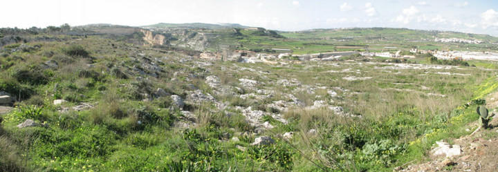
Wow! A temple all to myself to start the day! After a teasing text home, I headed south and soon negotiated the sharp hairpin bends north of Naxxar and stopped to check out a cart rut site. Not a site type that particularly inspires me, but seeing as I was passing ..... San Pawl tat-Targa Cart Ruts — Fieldnotes24.01.08ceThe winter greenery made it difficult to work out this site, but it must look fantastic in the summer (I bought "Malta before History" - Miranda publishers - expensive but exquisite - see page 394 - as my holiday souvenir) with ruts running straight across flat ground and bending round and down the slope. There's extensive quarrying in the area - almost right up to the edge of the ruts. San Pawl tat-Targa Cart Ruts — Images23.01.08ce
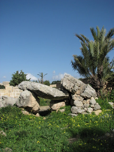
.... and then headed on to the west towards Mosta to find the dolmens of Wied Filep. Wied Filep — Fieldnotes24.01.08ceI guess I approached from the easy direction, as I pulled off the main road (Ghargur to Mosta) heading west from San Pawl tat-Targa Cart Ruts just before Mosta fort and with a group of houses to the left, and looked to the right and there was the walled enclosure! Overlooking St Paul's Bay, dolmen A is the larger of the two with a capstone 3.6m x 1.7m supported on three (?) stones about 1.4m high; dolmen B is smaller, supported by the edge of the plateau on one side and low stones on the other - its capstone is about 3m long. Wied Filep — Images24.01.08ce
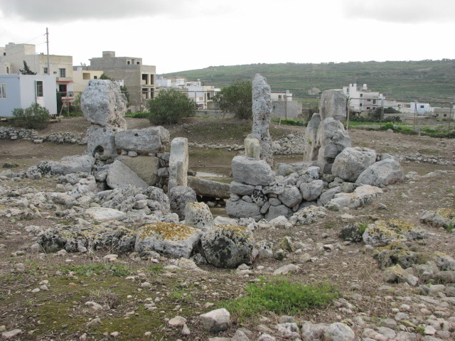
Feeling proud of my achievements so far, I proceeded to get lost in Mosta, but eventually found the right road to head towards Mgarr and another temple. Ta' Hagrat — Fieldnotes24.01.08ceThis site is currently only open to the public on Tuesdays 09:30 - 11:00. It's signposted but the easiest way to find it is to head west towards the dome of the church in Mgarr and watch out for a side street to the left about 200m before you reach it. The site has a low wall but high railings surrounding it, and a security hut and portaloo - and a gate with a big padlock! The site was excavated by Sir Themistocles Zamit over various periods from 1923 to 1929, and then restored in 1937 by his son, Charles. There are two buildings here - a main temple with a smaller one to the north. The main building follows the usual trefoil pattern with apses arranged around a central room, and the floor of this central area is lower than those of the apse rooms. The main facade is concave, and there are 3 large steps from the forecourt through the restored trilithon into the temple. The small temple has a similar if slightly more irregular shape, but without the impressive entrance stones. Ta' Hagrat — Images24.01.08ce
Then back a few miles to the village of Zebbieh. Skorba — Fieldnotes24.01.08ceThis site is only open to the public on Tuesdays from 11:30 - 13:00 - so would tie in nicely with an earlier visit to Ta' Hagrat if you plan carefully. The site was noted in 1914 by Themistocles Zammit but not excavated until 1937 by Captain Charles Zammit - with only preliminary work carried out then and further investigations put on hold by the outreak on WWII. A full survey was eventually conducted from 1961 (David Trump) and showed that despite the poor state of preservation, it was indeed a very important site. There are two temples here - enclosed by a nasty wire fence with a guard portacabin inside but a blue tardis loo outside (cheers!) - and then to the east, behind a low wall, are the remains of two huts. Skorba has infact given its name to two of the periods of Maltese prehistory - Grey Skorba (4500 - 4400 BCE) with its undecorated grey pottery and finds of hunting implements and obsidian and flint - and then Red Skorba (4400 - 4100 BCE) with its pottery covered with a red clay slip and highly polished; however finds from the site show its use for perhaps 2000 years. The wire fence only really encloses the better preserved west temple, and cruelly cuts through the ground plan of the east temple, leaving the red skorba huts outside and almost hidden - I'm glad I rechecked my notes and found the huts as they revealed important finds (a group of figurines, pottery and goat skulls) and were suggested (by Trump) to be part of a shrine. The west temple has a trefoil shape, with only really the back apse and one megalith at the entrance with any height. A noteable feature is a series of libation holes at the entrance - the flooded area when I was there. Libation holes may have been used for liquid offerings, but there's also some discussion that they were used as a tethering point for animals (for sacrifices). Skorba is signposted from the road from Mosta/Mdina to Mgarr - watch out for the square to your left after the road climbs uphill as the temples are at the end of this, at the edge of the village. Skorba — Images24.01.08ce
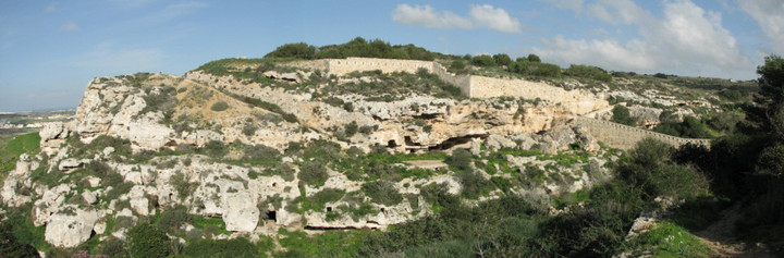
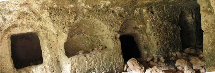
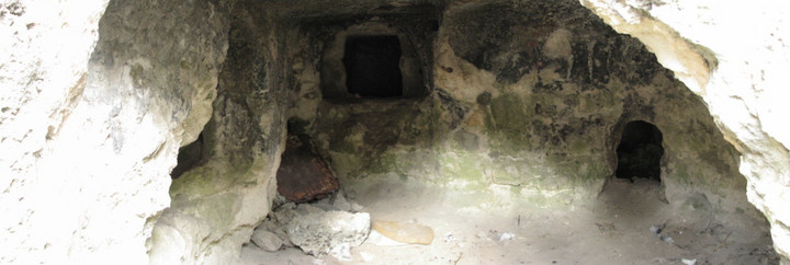
Time to head south, and only a couple of miles south of Mgarr I pulled up at a tiny chapel with a glorious view to check the map (again!) as I'd noticed a few cart rut sites and tombs marked along the way - and miraculously was in just the right place. Bingemma — Fieldnotes25.01.08ceAt Bingemma gap, along the Dwejra section of the Victoria Lines, there's a tiny chapel dedicated to Our Lady of Itria with a Punic tomb underneath it, but if you look to the right of the chapel, there's a path down to a network of rock cut tombs believed to date back to the Bronze Age but also reused in Punic times, by early Christians, and also as refuge for local farmers during WWII. I've not as yet managed to find any evidence of the exact age of these tombs (the map clearly says prehistoric) but spent a very pleasant hour or so scrambling in and out of them in glorious sunshine. Bingemma — Images23.01.08ce
I decided against trying to find the temple at Kuncizzjoni (Qortin l-Imdawwar) or the bronze age village nearby, on private land and difficult to find, I'd been told, but continued on south, getting lost again round the outskirts of Rabat but eventually finding the road to Dingli with the intention of taking a look at Clapham Junction - but got lost again and before I knew it was a mile or so south of Siggiewi on very dodgy backroads and hence not far from the two most famous sites, Hagar Qim and Mnajdra. I knew I'd missed the dolmen at Misrah is-Sinjura and that the next two were closed to the public (see Malta news post) but decided to continue on anyway. I pulled up at the almost empty car park, and a taxi pulled in behind me disgorging a young American couple "You do know it's closed" I said. She'd not been keen on the visit and the info didn't go down well. Oh dear! I was only able to walk round the outside of these two temples, but highly recommend you take a look at Fitz's excellent blogs Hagar Qim and Mnajdra for great photos and details of the spectacular sites. Hagar Qim — Images25.01.08ce
Mnajdra — Images25.01.08ce
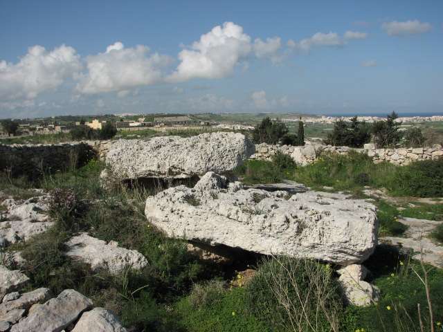
I wandered round the fencing, taking the path recommended by a friendly hunter I passed round the right of Mnajdra to get a view into the temples, past the occupied guard hut complete with dogs, and right round to the amazing view of Filfa with the sun on the ocean from behind the clouds - what a magical place! The walk back up towards Hagar Qim, I was accosted by a local man out walking who recommended a small beach and cave further along the path (not the Blue Grotto, somewhere much quieter) but it wasn't swimming weather yet - in fact he expressed considerable concern that I had goose bumps from the chilly afternoon breeze, and that I should put on more clothes to avoid getting ill - bless him! Even though these sites are closed, if you find yourself on Malta in the next few months, still visit - if you can bear to be so near yet so far. The area is stunning and I'm sure the picnicing and swimming spot nearby would be a winner. From here, I headed towards Zurrieq, and promptly got lost yet again. A few u-turns and right-round-the-roundabout manoeuvres I ended up on the road to Hal Far in search of Wied Znuber dolmen but passing the sad refugee camp on the disused airfield, I lost my concentration and bearings, and glee for the day's discoveries, and took yet another wrong turn. Before I knew it, I could see the ugly container port at Pretty Bay and headed to Birzebugga. By this time, you'll not be surprised to hear, the day was drawing on, but I knew I had to make one more stop - and caught a glimpse of a temple sign. Borg in-Nadur — Fieldnotes26.01.08ceBorg in-Nadur is under the care of Heritage Malta and is not currently open to the public. As well as the temple, there's the remains of a bronze age settlement to the south west and the possible remains of a room to the south east. The area immediately in front of the (unusually not concave) facade of the temple is being used for vegetable cultivation and there's a security hut, similar to those I'd seen at Ta' Hagrat and Skorba. The site was noted possibly as early as 1536, but definitely from 1647, with excavations being carried out by Margaret Murray in 1920s. It's hard to make out the site apart from its entrance megaliths but aerial photos do show a four apse structure to the south east of the main enclosure. There's a fair bit of rubble around, from excavations and local field clearance. Borg in-Nadur — Images23.01.08ce
With the sun well and truly setting, and rush hour starting, I headed north then round the Valletta conurbation, through crazy traffic (I only took the wrong turn once, but to get back on the right route I twice had to cross 4 lanes of insanity!) and miraculously ended up home safe. Phew! Just to point out, Malta is a very small island and I didn't check the mileage I'd done, but I used less than 10 euros worth of petrol on the day trip. |
24th January 2008ce Edited 26th January 2008ce
sals's TMA Blog
Latest TMA Blog Posts
|

Comments (0) |
|
| You must be logged in to add a comment | |