|
|

|
Kintyre: Latest Posts |
Blasthill (Chambered Cairn) — Images (click to view fullsize) |
|
 Posted by GLADMAN
8th August 2015ce |
Blasthill (Chambered Cairn) — Fieldnotes |
|
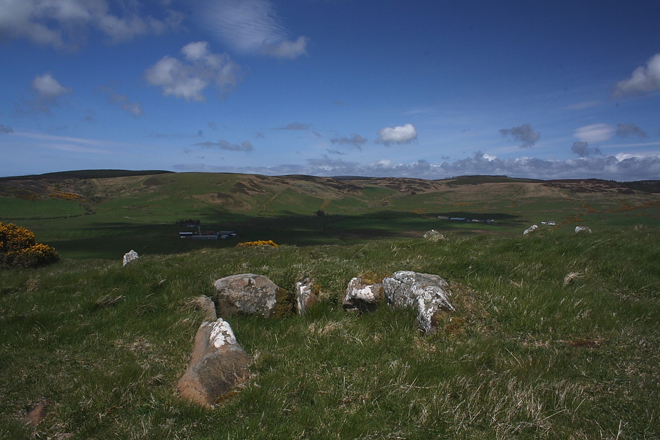
Located below and to the north west of the summit of Creagach Leac - the almost entirely grassed-over Bronze Age cairn rather contradicting the 'craggy, slabby' references inherent in the name - this excellent chambered cairn is, to my mind, the finest of Kintyre's ancient monuments... although I guess another chambered cairn hidden away in forestry a little to the north at Greenland runs it damn close. Hey, even the sardonic Greywether rated what is still to be found here gracing the rough pasture separating the farms of Blasthill and Macharioch. I approach from the village of Southend, the hill rising above to the north bearing the tell-tale contours of Iron Age earthworks to off-set the fact that the later settlement is not, in actual fact, the 'south end' of anything, let alone Kintyre... yeah, that accolade, of course, belongs to the (in)famous Mull a little to the approx south-west. Chances are you might have heard of it referenced by another of the area's ancient relics? Anyway, crossing the Conieglen Water at Mill Park I ignore the immediate left hand turn to follow the minor road past Blasthill Farm (on the left) and, in the interests of symmetry, Kilbride (on the right). It is currently just about possible to park - without causing offence - in the entrance to the driveway of an unidentified house a little beyond 'Suilven'. Needless to say that's not the celebrated mountain... or else I'd suggest you dispose of that Satnav in the nearest litter bin forthwith. Hey, do it anyway. Before it becomes self aware. As Greywether notes the track opposite the aforementioned Kilbride is key here with a field gate, fastened with nothing but ubiquitous rope, encouraging even the somewhat reticent Englishman to enter. I head for the far (northern) shoulder of Creagach Leac, encountering a pretty worthy area of bog upon abandoning the sanctuary of the track, wetland enlivened by the vibrant hues of the occupying gorse. This formidable natural barrier duly breeched, the way lies open to the fabulous chambered cairn located, unseen, beyond. To be fair there isn't an excessive volume of 'cairn' material to be found here. No soaring, enigmatic vertical profile; rather the well preserved/restored (?) orthostats and internal features of a Clyde-type chambered long cairn. Arguably the most impressive component is the crescent façade at the eastern end of the monument emphasising the entrance to the axial chamber. As you'd expect with such a cairn there is also a lateral chamber, this within the southern flank and possibly sited to focus upon the summit of Creagach Leac since the northern flank, overlooking the fertile fields bordering the Corachan Burn, would've otherwise seemed a more natural choice to me? In addition, more-or-less the entire footprint of the cairn is defined by the remains of a peristalith. OK, none of the stones are that large, but substantiality has numerous measures, so to speak. According to Audrey Henshall (1972) this long cairn is "about 72ft overall, with cairn material remaining to a depth of only about 3ft... The stones are irregular in shape and pointed, the tallest, 3ft high above the turf being the north portal." Blasthill is orientated approx east/west which, given the nature of the landscape, would appear very deliberate policy on behalf of its erectors. Let's just say that otherwise it wouldn't make much sense.... not with a glorious vista in the general direction of the Mull of Kintyre there for the taking to the west and the aforementioned aerial view - looking across Corachan Burn to distant hills - to the north. OK, the low mass of Creagach Leac (413ft) obscures any far-reaching outlook to the south, but east still wouldn't have been my choice upon aesthetic grounds. My assumption is therefore that other factors held sway back then. Whatever the reasoning, the monument is a fine place to hang out for a few hours in the sun before finally moving on to the Bronze Age summit looming insistently above. |
Posted by GLADMAN 6th August 2015ce |
Ronacan Bay (Stone Fort / Dun) — Miscellaneous |
|
Drive By. This Dun is easy to spot when driving along the A83 overlooking Ronachan Bay. There is a handy car park right next to the site. Unfortunately time constraints prevented me from a proper visit. However, the site can be seen as a flat-topped, fern covered mound. Great views. Canmore states: This fort, occupying the summit of an isolated rocky knoll, measures 24.5m x 18.5m within a 6.1m thick wall, now reduced to a grass-covered stony bank, not more than 1.0m high. A number of facing stones are visible in situ as shown in plan. A subsidiary crest line, traceable all round the knoll except on the W, may represent the edge of a terrace made as a seating for the outer face of the wall. The exceptional wall thickness would allow for mural chambers and galleries but no trace of such structures are now visible. The entrance is in the E. A D-shaped enclosure, formed by a low bank, and measuring 27.5m x 9m internally is situated at the base of the knoll, immediately SE of the entrance. Without excavation it is impossible to assess its relationship to the fort. RCAHMS 1971 |
Posted by CARL 5th August 2015ce |
Lochorodale 2 (Chambered Cairn) — Fieldnotes |
|
Visited 26.7.15 Directions: From the B842 take the minor road signposted Dalsmeran. Drive up the steep and narrow road, past Homeston Farm, until you reach a kink in the road at the top of the hill. The cain is (somewhere) next to the road on the left (when looking uphill). We were staying in the lovely (and posh!) Oatfield House B+B and this site was only a short distance drive to the south. How could I not visit? Unfortunately the site was totally overgrown with chest high ferns. I trampled about in the wet vegetation but there wasn't a hope of finding the remains of this chambered cairn. This is definitely a site which requires a winter visit. On the plus side there are fine views to be had as you drive back down the hill over the surrounding countryside. |
Posted by CARL 5th August 2015ce |
Ardnacross (Cairn(s)) — Fieldnotes |
|
Visited 26.7.15 Directions: A short distance north along the B842 from the Glenlussa Lodge standing stone. I viewed the site from the road, which is a field of long grass. I could see no sign of this chambered cairn. It has either now been reduced to nothing or so little remains it is hidden by the long grass. I was too wet and tired to go trapsing about in the long wet grass to go looking for any remains - lightweight that I am! Canmore states that in 1960 it was about 24.5m in length and 1.5m in height. It is certainly not that big now. |
Posted by CARL 4th August 2015ce |
Glenlussa Lodge (Standing Stone / Menhir) — Fieldnotes |
|
Visited 26.7.15 As Postie says, you can't miss this big 'fella. If you need any help it is near a telegraph pole. In saying that, if you can't see the stone the chances are you won't see the telegraph pole either! It is side-on to the road and approximately 2m high. There are good coastal views from the stone. Looks rough out at sea today. Glad I am a land lubber! |
Posted by CARL 4th August 2015ce |
Correchrevie (Cairn(s)) — Fieldnotes |
|
About 500 metres northeast of the cairn http://canmore.org.uk/site/295414/corriecrevie |
 Posted by tiompan
4th August 2015ce |
Correchrevie (Cairn(s)) — Images |
|
Posted by tiompan 4th August 2015ce |