


13/4/02-looking along the row towards Arthurs Seat and Edinburgh...

13/4/02-the linear cemetery is almost in the middle of the pic. This is taken from atop a large dune to the east of the site. You can just about make out the rows of cairns which look like tufty hillocks in front of and to the side of two large dunes.


5/4/02- from the top of the mound looking in the direction of the standing stone.


‘There is a famous cave at the foot of Schiehallion where, tradition has it, fairies loved to dwell. There, it is said mortals from time to time dwelt among them, and interesting stories are told of the strange ways in which they were rescued from their power. Behind Schiehallion, again, on Creag Chionneachan, is one of the spots where the old Fingalian warriors were supposed to lie on their elbows awaiting the third blast of the horn that is to raise them to life again.
From ’ A Higland Parish or the History of Fortingall’ by Alexander Stewart 1928.
‘…Schiehallion (3,547 feet)- i.e. the hill of the Daoine Shi or the Fairies’ Hill. If all the tales one hears related by old natives of Rannoch could be fully relied on, Schiehallion in days of yore used to be a favourite resort of the fairy folks, and more especially once a year, when all the various tribes throughout Glenlyon, Rannoch, Strathtummel, etc. congregated. Here they used to assemble in large numbers and hold their annual convocation, presided over by the beautiful and accomplished Queen Mab, gorgeously arrayed in her favourite green silk robes, with her abundant crop of beautiful golden-yellow hair waving in long ringlets over her shoulder down to her waist. It is said that there are a long series of mysterious caves, extending from one side of the mountain to the other.‘
From ‘Rambles in Breadalbane’ by Malcolm Ferguson 1891.
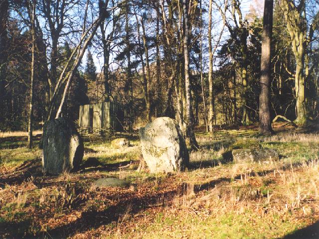
Crow Stones
Monday 15/4/02
Only by the use of the pylons and an old sheep fold was I able to locate this site. With the help of the 1:25000 map I knew that these stones were almost in line with the last pylon before the road. This oval of stones really is huge, but it’s very difficult to perceive the site overall as only four of the about 19 or 20 stones are not hidden in thick heather. This site appears on the OS map as an arc with it’s open side facing NE. This is clearly wrong- there are stones along the NE arc. If anything there may be a gap in the very SE, but I reckon the stone(s) from here have either sunk in the peat, or have been removed. Were this site on a solid grass plain I think it would be of great importance and much visited. However, most of the stones are slowly sinking or have sunk into the peat and practically all are hidden in the dense heather. The site measures 43 m NW/SE by 33 m NE/SW- a fairly large monument- especially considering the other sites in the Whiteadder area.
Kingside Burn Stone Setting
Monday 15/4/02
Bit of a collector’s item this one- another tiny megalithic monument- the tallest upright being only about 35 cm high. I counted 5 stones- 3 of which protruded upright. Next to the largest red sandstone one was a smaller grey stone which had tiny cupmarks all over its inner surface, but these may be natural. Some of the monuments of the Whiteadder area, such as this, are like megaliths-in-miniature! This site is almost directly underneath a pylon so the air really does crackle and buzz with energy.
White Castle Hill Fort
Monday 15/4/02
At the lay-by here is an old triangular pillar with the vertical words’ East Lothian District Archaeological Trail’. On the top is a very old map and this site was apparently Number 1. We’ve traveled here along the most fantastic road from Whiteadder- I use the word ‘road’ in the widest possible sense- single track, fords all the way along it and massive potholes and frost damage. You have to stay away from the edges of the road for fear of driving into the great ditches where the road has just collapsed! The precarious driving is certainly rewarded though- rounding one of the steep hills the county of East Lothian just opens up in front of you stretching all the way in the distance to the Firth of Forth and taking in Traprain Law, Berwick Law and the Bass Rock. Then, in the foreground, is this fantastic hill fort. There’s a lay-by right next to it and the remains of an old notice board. Three defensive ditches on this southern side, whilst the north and east sides fall away sharply to the Thorter Burn. A most fantastic setting.
Nine Stone Rig, Whiteadder
Monday 15/4/02
Nine gorgeous greystones- mostly brilliantly angled, some rounded, one earthfast and one very large recumbent. The recumbent is just over 2 m long by about 1 m wide. The tallest upright to the NW stands at just over 1 m high, whilst a small boulder to the SW is just 25 cm or so high. If anything these stones look to be graded towards the NE as the smaller and more rounded stones are in the SW arc of the circle. The ENE stone appears to have a single cup mark on its uppermost face. High above our heads songbirds are singing- Aed was singing too for a bit, but is getting a bit grumpy- no wonder- stuck in his backpack on this desolate moorland with some old stones when it’s meant to be lunchtime! To the south of us run a line of pylons which even from this distance we can still hear the buzzing and crackling in the damp air.
Kell Burn Alignment
Monday 15/4/02
As we walked up the small hill to this tiny megalithic monument the sun made a brief appearance from behind the clouds and mist. These 6 ‘large’ stones stand on a mound about 2 m high which for all the world looks very much like the remains of a cairn about 9 or 10 m in diameter. Of the ‘larger’ remaining stones only one is upright and stands a mighty 40 cm tall. This is one of four linear stones running perfectly N/S. The other stones are now (1) earthfast, (2) 20 cm high, (3) recumbent measuring about 60 cm long by about 27 cm wide. A small, compact and beautiful Summer Solstice monument in some fantastic scenery at the head of Whiteadder Reservior.
Mayshiel Stone Setting
NT630646 15/4/02
As we head up the Lammermuirs from Gifford, the drizzle started and the list brushed the tops of the highest peaks. Aed is fast asleep snoring away in eth back of the car whilst H-dog is just desperate to be out in the hills! Just about 7 or 8 m to the south of the road is a small (about 3 m or so in diameter) semi-circular peat banking with 7 stones protruding from it. The largest stone is only about 60 cm or so high and the circle is open to the desolate moorland to the south. About 10 m ENE of this semi-circle is another stone being about 80 cm wide by about 40 cm high- an outlier perhaps? Certainly this stone appears to be of the same age as those making up the main circle.
These caves were excavated in 1908 and were found to contain an iron knife, a socketed spearhead, bone button, parts of glass armlets, a whetstone, a deer horn pick, a bronze pin etc. In other words- remains of several occupations. All the finds relate to the early Iron Age. The wall built across the larger cave is reckoned to date between the 4th and 12th centuries.
Hanging Rocks Caves
Saturday 13/4/02
Two caves here- the westernmost being the smaller of the two. This is a bit of a Fisher-Price ‘My-First-Cave’ for Aed! In the smaller cave the roof and the cliff leading from it are blackened- possibly from years of fires built in here. The larger cave is just around the cliff and has a small wall built at the entrance. You can walk about 10 m or so into this one- the other requires stooping even to get in. I had a check of the wall and roofs of these, but no signs of markings.
An Iron Age date has been suggested for these cairns. Apparently to the west of the cemetery are the remains of other small cairns that were excavated in 1902. These contained cists that had been previously disturbed and only found to contain pottery fragments. One undisturbed cairn contained and oval grave with three human skeletons. At the northern end of the same cairn was found four human skulls and other skeletal remains. Other finds picked up from around the site included pieces of decorated and cinerary urns, flints, arrowheads, knives and scrapers all of which are in the National Museum of Scotland.
Gullane Links Linear Cairn Cemetery
Saturday 13/4/02
Finding a group of 13 cairns in an active dune system ain’t easy. We had to walk past the area we thought they were, join the definite path along to the caves at Hanging Rocks and re-trace the main path back round again. There’s only one path marked on the Explorer map, but in reality there are paths all over the place! I’m sitting atop a steep dune- there are beautiful spiders crawling over my legs- black ones and pale green ones. I even disturbed a falcon who was hiding in the long grass up here. Looking down on the cairn cemetery I can still count about 11 of the original 13 cairns mentioned in the fist field report from 1924. It’s still possible to make out the two parallel rows running off SW pointing to the Pentlands and Arthur’s Seat across the Firth of Forth. According to the latest RCAHMS report only 4 definite cairns could be found. Although not the most obvious of sites, once the parallel rows have been established you can walk across one of the rows of 6 cairns counting 5 in the parallel southern row. These cairns are exactly as marked on the map- however- there are two paths here- stick to the higher one that goes along the edge of the raised beach and not the one by the shore. The cemetery lies to the south of a large dune and inland from a small rocky headland.
Danes Stone (AKA Pitfourie)
Friday 5/4/02
In the last street in Moulin before the fields and forest of Craigower Hill stands this monolith called the Danes Stone. This whinstone block is just over 2 m high and aligned approximately E/W. Apparently several more stones are said to have stood here and are supposed to be half buried in the field, but the OS did a careful examination and no such stones were found.
Straloch (AKA Cotterton or Davan) Standing Stone
Friday 5/4/02
Of all the times we’ve traveled along this road I’ve never even noticed this stone- despite it being over 2 m tall! It’s tucked down next to the River Ardle behind some trees and a over a large ditch down on the same level as the river. Despite being so tall, the stone is really thin- only about 40 cm or so. It’s aligned NE/SW and has an oblong section missing from its northern side. This shape obviously makes it a great scratching post as the stone has been rubbed into a great shine by cattle.
Wester Enochdhu Standing Stone
Friday 5/4/02
Only about 5 minutes drive north from the Balnabroich stones- another monolith sits by the right hand side of the A924 heading north. Easily seen from the road as it sits on a bank at the very edge of the woods here. Kat parked on the verge opposite and I ran out for a look. It’s about 1.5 m high, leans slightly to the north and its broadest edge points off up Kindrogan Hill to the NW. Although right next to the road, there’s a certain tranquil air next to the stone in amongst the trees..
Balnakeilly Standing Stone
Friday 5/4/02
So- is it a megalithic monument or not? According to the RCAHMS database this stone may have been erected in the mid 19th C to adorn the entrance to Balnakeilly House. Apparently the general regularity of the stone makes it appear ‘modern’- I’m not entirely sure- I’ve seen many other monoliths as regularly shaped as this one- it’s also set back from the road quite a bit and in a group of trees. If it were to adorn the entrance it would have been given more prominence methinks. The stone itself is over 2 m high. I had a quick look at the new OS Explorer map and noticed that it’s not marked in antiquarian font, although all previous editions have marked it as so. Hmmmm.
‘Two miles east of Dunkeld are the Standing Stones of Newtyle, commonly called the Druid Stones, near the “Doo’s Nest”, a projecting crag on the road to Caputh. These stones were probably monuments before the Druidic period, but the Druids or Pictish Priests generally annexed such monuments, and the name clings through the ages. The Newtyle Stones are possibly remains of a Circle; it is conjectured that, as a spur of Newtyle Hill rises sharply behind, the remainder of the Circle might have been where the road now runs, and had been destroyed during its construction. They are of common quartzose schist differing in height. The largest is over 6 feet at the north corner and 3 feet at the east. A fence divides them from the road; unfortunately, owing to the growth of ferns, bushes and trees, there is a danger that they may soon be lost to sight. Dr Marshall in his “Historic Scenes of Perthshire” alludes to these two upright stones at the Doo’s Nest, but says they are supposed to mark the graves of two Danish warriors returning from the invasion of Dunkeld. Antiquarian research, however, as reported in the Society’s Proceedings, places them among pre-historic monuments.‘
From ‘Dunkeld- An Ancient City’ by Elizabeth Stwart (1926).


