Balnabroich Two-Poster
Friday 5/4/02
I’ve always spied the nearby standing stone as we’ve driven past this way hundreds of times, but this pair are less obvious being further down a farm track and amongst a group of trees. I nipped down to Balnabroich farm and was readily given permission by the farmer’s wife to have a closer look at the stones. I headed back up the farm track, hopped up the small dry stane dyke and walked through the trees and daffodils up the small (natural) mound upon which these two stones have been carefully placed. These huge blocks have been aligned N/S- the northernmost stone pointing the way to the Balnabroich standing stone in the filed that these pair overlook. The north stone is almost 1.5 m high and is a thick rough block of whinstone with a flat top. The southernmost stone is even more irregular and has two very large almost cup marked shaped indentations on its upper surface. These look natural- one of which has a fantastic deep groove running from it down the west side of the stone. Even if these are natural I can’t help think that this stone was specially chosen and placed for these features.
Martin
Balnabroich Standing Stone
Friday 5/4/02
This stone is easily spotted on the A924 from Bridge of Cally to Pitlochry- it stands in a filed next to the road and is usually surrounded by cattle who seem to be strangely drawn to it- probably for a good scratch! It looks almost square in section being about 1.5 m high. It is also aligned perfectly with the nearby (in fact, at the end of the field) Balnabroich Two-Poster.
lotsa pics of this stone on Martin’s site
Dunkeld Park Standing Stone
Wednesday 3/4/02
Almost at the end of a long day of walking- just time for one final detour. Just before heading past Polney Loch and back into the forest I cross the road and sitting tucked in a corner of a field of sheep is the stone. There’s a strip of land between the road and the field so I jump down the dry stane dyke to get a closer look. Across what appears to have been a dump- old bottles and rolls of wire strewn all over. I get a perfect view of the stone. It’s fairly small being about 1.5 m tall, and appears to be aligned approximately E/W. I take a couple of pics before heading back through the broken glass and jumping back up onto the road.
Clachan More Two-Poster, Dowally
Wednesday 3/4/02
When I was at the house of the very helpful woman enquiring about the nearby St. Anne’s Well, I also asked about the exact location of the Clachan More standing stones. or Two-Poster. I had kept my eyes peeled for them on the way down off the hills, but to no avail. The exact location is indiscernible on the OS map. I was told that they used to stand over the other side of the A9, but a bus hit the only remaining upright of the pair in recent years. On my way back along the path next to the extremely fast and busy A9 I scoured the fields opposite for any sign of the megaliths, but nothing- just some houses and caravans. As I was passing a row of cottages I decided to ask one more time. I was greeted by another friendly old woman- she know of the stones (but not by the name of the Clachan More) as she had lived in Dowally for 50 years- long before the A9 screamed a matter of metres from her front door. ‘Aye’, she said, ‘they used to stand where those new caravans are’. Apparently the new owners of the houses over the road saw fit to demolish the rains of the stones and clear the site. I certainly wasn’t crossing the A9 to check out the site- it would be easier and less messy to just shoot myself than attempt a crossing on foot! However, I could clearly see that the ground around the caravans had recently been landscaped with some large boulders- probably the remains of the once great Clachan More.
I leave Dowally with its Holy Well now a rockery and Two-Poster now a mini caravan site. I head for the hills and the forest as the sky darkens and the air gets colder.
St. Anne’s Well, Dowally
Wednesday 3/4/02
I left Aed, Kat and H up the hill whilst I ran the half mile or so down through the forest off the hill and into the back of the village of Dowally to check out this well and a nearby Two-Poster. From the 1:25000 map it looked like the well was immediately behind the craft centre at Dowally- so there I headed. the most unwelcoming craft centre in Scotland- ‘No’ this and ‘No’ that signs all over the place. Undeterred, I ventured in and the woman looked distinctly unimpressed before I had even said a word. I asked about the location of the well, which I explained that from the map it looked like it was directly behind the building we were currently standing in- ‘no- don’t know a thing about a well’ was the swift reply’. She even questioned as to how old the map was (bought it last week as it happens- revised only last year). She did, however, point me further up the hill in the direction of a cottage called ‘Anne’s Well’- I made a swift exit past the shelves of imported crap posing as local crafts. Headed up to the aforementioned cottage, but no reply. So- I tried at the last house before the hill. I was greeted by an extremely sweet old woman- a friendly soul at last! However, when I asked about the well she told me that it was no longer possible to visit- it had gone septic and overgrown and somehow disappeared into folk memory- indeed, her mother used to drink from the well. I bade farewell and on the way back down the hill I checked the map again- now I knew how many buildings were in eth area- the site of the well was definitely behind the craft centre. As I walked past again I peered round the back (I was being closely watched by the owners all the time)- just past the ‘Strictly Private’ sign I could see… a new rockery type garden. Fantastic.
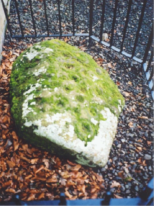
Newtyle Two Poster (AKA Dunkeld Standing Stones)
Tuesday 2/4/02
I thought these two stones would have been more difficult to see- I expected them to be hidden behind a wall, or obscured by trees, but are easily spied as we whizzed past them on the way to Dunkeld- to be paid a visit on the way back- so I made mental notes of where on earth to park whilst exploring this site. There’s a small entrance to the now disused Newtyle quarry which we reversed into. It was a bright Spring evening, the sun shining through the still leafless trees These two massive blocks are aligned NNW/SSE. Their northernmost faces are covered in a thick mat of moss, whilst the faces currently bathed in sunlight and shining and clean. What is really surprising is how sharp and the angles and edges of these great stones are- as if recently quarried (well- apart from their blankets of moss). The north stone is just over 2 m high, whilst it’s partner (which stands about 3 m or so to the south) is around 1.5 m tall. Both of the tops of the stones are angled at approximately 45 degrees south to north. These paired stones, or two-posters, are one of at least four that I know of in this area. To the south are the NE/SW aligned Staredam Stones, to the NW are the Clachan More (although re-writing this from my scrawled field note-book I was blissfully unaware of their fate) and to the NE are the Balnabroich Stones.
Bandirran East Stone Circle
Saturday 6/4/02
This is gorgeous. This is absolutely gorgeous. I’m sitting facing the sun which is filtering through the trees. I’m being bathed by the suns rays slanting through the branches high above me with my back against this gargantuan monolith at the centre of this circle. All around me are wood pigeons, songbirds, a few grouse and a light, light breeze. There are groups on insects hanging in the beams of the sunlight- its rays also lighting up the moss covering of another huge stone in front of me- it’s now recumbent and must be over 2.6 m long. I’m almost lost for words here- I’m blinded by the sun, watching the odd car go past on the nearby road I can make out through the trees- can hear someone shooting nearby- but me- I’m mesmerized. I can count 7 stones (including the recumbent) around the central monolith and a small boulder to the SSE. Fucking hell- I was about to check the alignment of the great face of the central stone when my compass reversed polarity. Jeez- the shivers are running up my spine and my head has flipped- I fell very woozy. This is getting silly- it’s done it again. My head is being beautifully fucked by this monolith in the centre of this circle. I’ve moved away from the stone, walked around a bit- it’s finally settled down. The face is aligned WSW.
More pics and info re this site
This circle is part of the South East Perthshire Stone Circle Trail (along with Colen Wood and Wolfhill). I got a leaflet about the Trail from Perth Museum (01738 632488). I couldn’t see the way in to the woods so asked the very happy farmer at the cottage next to the woods. Just before the end of the trees at the west there’s a stile over the fence from the B953 roadside. Walk north and you’ll see the green ‘Stone Circle’ sign.
Bandirran West (AKA Woodburn Cottage) Stone Circle
Saturday 6/4/02
It’s a glorious Spring day- not a cloud hangs in the sky and the sun still beat down. It’s Saturday tea-time and I’m at the edge of a wood in the shadow of Dunsinane Hill. Standing at the edge of this stone circle. Watching the trees. Watching the sun. There are at least 10 stones in this circle- only 2 now remain upright and strangely enough they are at the SW of the circle. Judging from the other recumbent stones, it looks like they’ve been graded towards these two. The two uprights are both around 1.5 m high. The whole circle is surrounded by a small bank about 30 m in diameter, but closer inspection reveals the remains of a very old dry stane dyke which has accumulated moss and plant growth over the years. The woods here are sparse and old giving this site an air of great antiquity- the stones being covered in a thick blanket of moss. Burl makes mention of a possible centre stone to this circle, but I couldn’t see one- not made easy by the fact that there is an uprooted tree in the centre of the stones.
This article appeared in the weekend Scotsman a couple of weeks ago (I’ve had to abridge it to fit within 4096 characters)- looks like a replica of the stone may stand once again. Liked the quote from the minister at Stenness- ‘he was the god of war and bloodshed’!- aye- we’ll all burn in hell for it ;)
‘Orkney resident Morag Robertson has been at the forefront of a local campaign to
restore the prehistoric Stone of Odin for ancient handfasting ceremonies.
“People come from all over the world to see and touch the Neolithic stones,”
says Robertson. “Give them a marriage ceremony to go with it and you’ve got
a 21st-century goldmine.”
The ancient site was where Neolithic people celebrated growth and newly wed couples prepared for a fruitful union by joining hands through the hole and swearing an oath.
The tradition was brought to an end a century ago by a farmer who smashed the stone in a fit of pique when couples refused to stop walking over his land
But in Orkney, where 5,000 years of history still influences everyday life,
tradition is not wiped out that easily. Couples still go to the Standing Stones.
Recently there has been a growing interest from abroad in
travelling to Scotland for handfasting ceremonies. Orkney Islands Council
have recognised the tourism potential. They recently agreed to put money
aside to replace the Odin Stone.
Councillor John Brown, the chairman of the committee in charge of the
county’s heritage is also a geologist. “This is a World Heritage site so we can’t
put in a replica because we have no definite proof of what we’re trying to
duplicate. There’s only an old sketch. The nearest we can get is a slab from
the original sandstone bedrock that the other standing stones came from, but
we’ll have to put a notice there saying ‘substitute’.”
“Lets get on with it,” says Robertson, who is envisaging a new craze for the
21st-century.
Stenness minister Tom Clark is appalled at the idea of oaths being taken in
the name of Odin. “He was a god of war and bloodshed. The Kirk certainly
wouldn’t be involved in wedding packages connected with any of this.”
Local historian Peter Leith disagrees. “The folk who put up the stone were
prehistoric,” he says. “The name Odin only came with the Vikings later, so the
ceremonies go back far further, and anyway, the Kirk must have been part of
it a couple of centuries ago, because oral tradition says to break the troth you
had to go into the Stenness kirk together and come out through separate
doors.” ‘
Two sites in the Lothians which were *destroyed relatively recently*;
Muirhouses Standing Stone
Was at NT539787 (Sheet 66)
Described as a massive boulder- 4.5 ft high by a whopping 11’4” in girth. It stood on the summit of a low broad ridge. It was destoyed sometime between 1913 and 1975. It was said to have marked the northern limit of a battle which was fought here in the 9th Century.
Muirhouses South Standing Stone
Was at NT540780 (Sheet 66)
Described as being approx 4.5 ft high by 9’ in girth. The stone slanted to the north at an angle of 33 degrees. The base was packed with small boulders. It stood on the crest of a low ridge and was said to have maked the southern limit of the aforementioned battle.
This stone was destroyed in *January 1989*!
These stones stood approx 700 metres from each other and were intervisible.
A three sided stone approx 10 ft high by 3 ft breadth.
Approximately 3.4 m high and almost square in section (like many of the monoliths in this part of the country).
This stones about 9 ft high and about 6 ft in girth at base where it is roughly rectangular in plan. It’s been made from red sandstone. There are three cup marks on its west face. Deep grooves on the base of the stone were caused by a steam-plough!

Somtime in 1991?- A *careful* wax rubbing I made of the Pegasus symbol on one of the roof lintels.

24/12/01-are you fishy wishy wishy? Or are you just a face?


21/12/01-with the church to the left (now part of Napier University)


20/12/01-with the scheme which ruins the vibes

AKA Clach na Voile or the Stone of Fury. Rectangular block of granite approx 1 m N/S, 0.7 m E/W and 1.1 m high.
A large fuel tank was reported lying on top of this rock by the OS in 1969. By 1974 however, someone had the foresight to shift it! Approx 20 cup marks, 14 of which occur in two non-parallel rows of seven cups each.
A large rock outcrop with 18 cup marks and three cup and ring marks.
A hump backed boulder measuring approx 2 X 1.3 X 0.5 m high. At least 25 cup marks most of which are approx 7 cm in diameter, but one whopper of 14 cm diameter and 6 cm deep.
AKA Allt Kinardochy. An isolated boulder with 12 cup marks on the upper horizontal surface.
A cup marked stone that has been built into the SW gable end of a cottage. It has 10 cup marks. Apparently in 1967 there was a report of a small stone (1’6"X1’2”) lying near the back door of the cottage. However, a later OS report from 1974 was unable to loacte this- gone for good?
On a small square rock outcrop a single cup mark sits- measures approx 7 cm in diameter.
This site was re-discovered in 1994 by the Keltic Research Society. There was 28 single cup markings, three cup and ring markings and two cup markes with two ring markings each. Apparently this site was re-turfed and is probably now lost???
Five cup marks (one of which with a single ring approx 6” in diameter) on a stone approx 4 ft long, 3 ft wide by 2 ft high.
Ten cup marks on a large boulder were reported in 1886, but a later OS visit in 1974 reported that the boulder had split and five of the cups have disappeared. The boulder was originally approx 9 ft long, by 7 ft wide and 4 ft high.
Whilst sorting through pictures, fieldnotes etc for a sites in this area I realised that along the north and east sides of the Magickal Mountain, Schiehallion, there are at least nine sites of cup (and ring) markings. There are probably many more hidden away (see Garth Estate 3 for example) awaiting re-discovery. To the hills ;)
UPDATE! I was speaking to someone the other day who visited this site. Turns out it isn’t as obscure and difficult to reach as I thought. They have spent Midsummers night at Wallaces Cave and there’s apparently a very steep path from the cave heading right to the carvings. I’ll try this the next time- no more wading through rivers and scrambling up through mud ;)

20/12/01-you can just make out some of the cupmarkings at the base of the stone on the left hand side


24/12/01-a close up of the site from the other bank using the good ol zoom lens. I’ve added a small circle- you might just be able to make out the top of a spiral. How I spotted this I’ll never know (especially being short-sighted!).

24/12/01- the sight that greeted me after my scramble up here- yowzers! This is in a niche in the cliffs- from left to right: single circle, ‘shield’ symbol, single small circle, 5 notches, fish symbol, three single circles in a line almost horizontally, concentric circles. The double spiral, S-shape etc are on the rock face to the right of this. To the left- 30 foot drop to the river ;)

24/12/01- two single circles at the bottom left, large double spiral above, S-shaped spiral to left of this and above a single spiral!


Corstorphine Hill Cup Marked Rock
Friday 4/1/02
It’s a glorious Winters morning as me, Aed and H-dog head up Corstorphine Hill for our mornings walk and in search of this cup marked rock. Due to the large boulders and tree roots the path’s a bit bumpy for Aed’s off-road buggy, but we all manage to get up to the main path along the crest of the Hill. I’m trying to use the OS map and a Corstorphine Hill map to find this site, but there are so many paths heading off through the trees- we head in the general direction of south and hope for the best. The other problem is that there are so many rock outcrops and glacial pavements up here. Thankfully, there are a couple of buildings on the west side of the Hill and working out their position realised that we’ve actually gone past the site. Using instinct and following H-dog we head back along a lower path and through the gorse bushes a huge stone pavement area opens up before us, covered in snow, ice and frost. We slowly make our way across this and I almost walk straight over the top of the cup marks! The rock they are on has been cleared of frost n snow, and the markings are fairly shallow, but small amounts of snow remain in the depressions picking out a pattern of 10 cup marks almost forming a circle with 8 markings on the diameter and 2 in the middle. The views from here are inspiring indeed and especially on a bright and bitterly cold day such as today. From the Pentlands to the left right round to the hills of Fife in the distance, just able to make them out through the frosty air. These cup marks were only rediscovered in 1991 and I would be very surprised if these are the only sacred markings on this hill- we passed literally hundreds of rock outcrops on the way up here, many of which are almost now covered in vegetation.
The RCAHMS entry states that this site is ‘a most unusual and well-preserved series of carvings occur on the vertical faces of a shallow recess on an almost inaccessible rock ledge above the River Esk. Circles, spirals, triangles, an S-motif, a shield and other geometric marks and grooves are incised on the rock. These figures are quite unlike the more normal Bronze Age markings, and may be of a different date.’ The entry then goes on to state that an OS visit of 1954 discovered that it was not possible to examine the symbols closely due to being sited in a precipitous cliff. Then in 1975, the OS were unable to even locate the site.
Hawthornden Cliff Carvings (AKA Gorton House)
Monday 24/12/01
‘Inaccessible rock ledge…situated in a precipitous cliff.‘
I managed to scramble down the banking to the rivers edge opposite these cliffs as an OS report from 1954 said these carvings could clearly be seen from the opposite banking- however, this report is contradicted by a more recent one from 1975 saying that the site could no longer be located. I stood and stared for an age at the massive cliffs over the river from me scanning their couple-of-hundred-foot towering mass up and down and from left to right. I peered intently at the large vertical slabs where I would have expected something to have been, but nothing. There was, however, many areas covered by vegetation and I was about to admit defeat and say that this site has now been covered by plants when, just through the trees I saw it- a single spiral. It was on a rock face in a small recess about 30 or 40 foot up the cliffs above the river. That was it- I simply had to see them and touch them. Unfortunately the carvings were across the other side of the river and straight up a very steep and muddy banking and cliff face. There was only one thing to do and I did not think twice- I was entranced by the sight of that single spiral. I grabbed a huge stick from the banking and waded into the river, the cold water filling my boots immediately and freezing my feet. Actually, it wasn’t that cold considering it was the end of December- I’ve been in colder water (like surfing in the North Sea in April- brrr!). As it turned out (luckily) the River North Esk was only about knee deep. That was the least of my problems. I still had to get up about 30 or 40 foot of mud, cliff and trees. I tried working out a route, but had to return to my original crossing point as I came across a vertical rock wall with no holds. I started off up the mud and used the trees to swing horizontally above the river on my way up n up n up! I slid, I climbed and I scrambled and I bloody well made it- hahahahahahaha! And I was completely blown away. I expected a couple of carvings, including my enchanting spiral, but not the sight that greeted me. The overhanging vegetation, the red rock cliffs and these carvings- for all intents it looked like a forgotten Australian aboriginal sacred rock. Except here I was at this sacred and once lost Scottish aboriginal site. There were spirals, triangles, double S shaped spirals, notches and these circles all over- just plain circles. Not only these but an amazing fish type symbol- it looked like a horizontal Einsturzende Neubauten symbol. I’ve seen a fair amount of rock carvings on my travels, but this place, no- something very different about this place- it felt more primitive. The only similar spiral I’ve ever seen was at the Templewood circle. I was shaking- partly from exhilaration as I had just waded a river and climbed up here (and I’m not that keen on heights) but mostly I was extremely energised- I had made it here and it felt as though I was the first person to see these symbols for many, many years. I fired off about ten pics, but I was shaking so much I doubt if any of them will actually turn out okay. I eventually scrambled and slid back down to the river almost coming a cropper on a couple of occasions. I waded back across the river and back up to the main path. I was totally soaked, freezing and covered in mud. But most of all I was completely bedazzled. This precipice, high above the River North Esk is an extremely powerful, sacred and magickal site, made even more so due to its inaccessible and hidden nature. This site crackles and buzzes with energy.
Directions
Firstly- this site is *extremely* difficult to find and reach. Sometimes I turn into a complete idiot with no sense of fear, especially when it comes to exploring places like these (although I always retain my sense of respect). I could easily have been swept away in the river, fallen from the cliff (almost did) etc. Just cos I write about this site doesn’t mean I’m recommending an actual visit. Follow the A701 south out of Edinburgh. Pass Ikea on the right and head through Bilston. At the roundabout in Bilston take a left through Roslin. Go down the main street which turns sharp right and look out for the Roslin Glen signs before the main road turns right again. Down this steep road and park in the designated car park at approximately NT272628. Take the path across the river, under the castle drawbridge (see Roslin Glen Folklore) and follow it northeast along by the river. Paths lead off uphill, but stick by the river- pass Lovers Leap on the way along the path (see Roslin Glen Fish Carving). Continue along the path next to the cliffs above the river. The path descends down to the level of the river and in places is carved from the cliffs and takes the traveller along the river bed- it’s obviously only passable during periods of low rain/snow fall. Keep an eye out for Wallace’s Cave high above the river on the opposite side- the carvings are approximately 30 metres further round from the cave (north) and about 8 metres below it. Best to view from the other banking in the Winter with a pair of binoculars!