White Meldon Fort
14/7/02
From the glen between White and Black Meldon we started our climb deciding on this fort as opposed to the Black variety as this one also had a cairn on the top- always an added bonus! It was a steep climb of about 250m just about straight up from the road- we managed it in about 30 mins or so- probably fuelled on by the mix of last nights fine malts and curry and this mornings eggs rolls-mmmmmmmmm!!! Pouring with sweat and with the wind blowing in our faces we finally sighted both the cairn and the OS triangulation point which spurned us on. And what a fantastic view and rather extensive fort. We counted about 4 walls round the steep summit- the interior of which encloses an area of about 8 acres with the remains of 28 ring-groove houses. Some of these proved to be easier to see than others though. The cairn itself has been mostly piled up into a large modern looking mound from it’s original larger diameter- there are many large blocks still around the original outline. This must have been an inspiring (and pretty safe) place to stay. You can see way round the Border Hills and up to the Pentlands, over the Moorfoots- fantastic.
Martin
This healing well was a place of pilgrimage for many Scottish monarchs. James IV visited and left an offering in 1504. In 1617 James VI had it protected by a well-house with steps made for easier access. Cromwell’s troops demolished the well in 1650. Over 200 year later, in 1889, the well-house was once again carefully rebuilt.
Legend has it that St. Catherine of Alexandria let fall a drop of oil that she was carrying to Queen Margaret from Mount Carmel or Mount Sinai and a spring welled up. As well as treating eczema it was alleged that this well was used for treating leprosy, but this may be based only on the fact that the neighbourhood within which the well is situated- Liberton- may have derived from the name ‘Leper-Town’.
St. Catherine’s Well
9/7/02
AKA The Oily Well or The Balm Well
In the grounds of what is now The Balm Well restaurant lies this healing and Holy Well. Just over from the beer garden a red gravel path lined with stones (many of which have fallen on the path) leads down top the barred and grilled entrance of the well. The well itself is housed under a lintel dated 1563 (although this is thought not to be connected with the original well-house). The gate is about 1m high, whilst the stone frontage to the well-house rises to just over 2m. The thick oil shale for which this well is famous and gained it’s healing properties coats the entire well chamber interior along with the gate. As late as 1910 the water from this well was used as a cure for eczema. The stone work of the well-house only goes back about 1m or so, then the back of the well-chamber is housed under a grassy mound approx 0.5m high by about 4.5m in diameter.
Galachlaw Cairn
9/7/02
At the end of Galachlawside a small indistinct path leads off into the bushes and trees (and also a fence which I had to climb through). I had the GPS on and almost immediately where this small path joins the main path – lo and behold! I was on top of the cairn! Much overgrown with bracken, brambles and trees with a path going right over the top of it. At the NNE side of the path just over the top is a large hole about 1m deep by about 2.5m wide where it looks as if the cairn has been robbed. There was note of both an upright stone on the top in 1953 and an OS triangulation point in 1975, both of which have now disappeared. Although- about 11m ENE from the top of the cairn (which itself is approx 13m in diameter by just over 1. m high) is a large, partly earthfast, and moss covered stone. This stone is approx 1m long by about 0.5m wide by about 0.4m thick- could this be the original stone from the top of the cairn that has been chucked down the cairn?
Original Site
NT2805674241 Saturday 22/6/02
At the very bottom of Meadowbank Stadium carpark on the road to the velodrome is a large triangular stone laid into which is a metal plaque which reads;
‘This stone marks the site of St. Margaret’s Well. The dressed stone work of the fifteenth century wellhouse built over this ancient medicinal well and centre of pilgrimage was removed in 1859 and used to build a replica of it over St. David’s Well in the Queen’s Park and the remains of the medieval building were filled in in 1969.’
This spot was apparently the site of the North British Railway sheds which were named after the well. The main east coast line still runs past here only about 5 metres to the south.
Sunday 16/6/02
Well- it helps if you put the correct co-ords into your GPS- I thought something was up when the direction arrow was taking me into the middle of Hunter’s Bog! I re-entered the co-ords and this time followed the direction indicator round to St. Margaret’s Well- the original site of St. David’s Well being on the path behind what is now St. Margaret’s Well- I visited this site before visiting the original St. Margaret’s site at which the plaque confirmed what I had already thought- these are one and the same wells. In 1859 (or 1860) the well house which now stands here was moved and built upon St. David’s Well (which I imagine was a very less grand affair that the St. Margaret’s Wellhouse).
The well belonged to the manor house of Grange and was said to be Holy being associated with the nearby convent of Sciennes. It was restored by Sir Thomas Dick Lauder, but around 1870 the water from it stopped flowing. It fell into disrepair until 1887 when the original trough was uncovered at a depth of 5 foot below the site. Around 1892 the well was once again restored this time being supplied by the town water supply. Sometime between then and now it has been bricked up.
Sunday 16/6/02
Hidden away in a quiet street (Grange Loan) in Edinburgh’s Southside is the remaining frontage of this once Holy well. I would never have known of it’s existence had I not stayed near here for a while and came across it whilst walking home one day. All that now remains is the red sandstone front to the well with two pieces of metal either side. The sandstone has unfortunately started to crumble especially the block that is inscribed with ‘Penny Well’. Aed and I have stopped off here on the way back from Arthur’s Seat for a quick visit and some pics.
NT2822672710 Sunday 16/6/02
After climbing Arthur’s Seat Aed and I headed off the hill and all the way down to Duddingston. At the car park by the loch I checked the GPS, Explorer map and the RCAHMS broadsheet to try and get some bearing as to where the well might be because looking around it wasn’t obvious. As it turns out we must have passed it about three or four times and was only just above the car park! Hidden in waist high stinging nettles- I actually heard it before spying it. These days it’s partly covered by a concrete slab, partly by an older stone slab which still has the remains of an iron chain attached to the top- obviously once ended in a cup to partake of the curative waters! The water now flows from a small pipe on the front of a vertical stone slab- it tasted cold and clean! However- just to the left was a very boggy piece of ground- looks like some of the outflow has found another way.
Monday 24/6/02
After reading about the other markings on the Ancient Lothian website we find ourselves up here on a Monday afternoon. I’ve given Kat the GPS at the car park and let her follow a route to the waypoint. Turns out the co-ords for the main group of cup markings are a bit off, but I remembered where they were and took 4 sets of readings (with an accuracy of between 4 and 6 metres). As it turns out, the other cup marks are not that difficult to see- I dunno how I didn’t spot them the first time we came up here- guess I was just so chuffed at finding the main group after almost giving up hope.
Immediately to the east and up the hill from the main group are a group of 4 cup marks centred at NT2052874141. A large cup approx 15cm in diameter with the other three 7, 8 and 9 cm in diameter.
Down the slope (northwest) is a single cup (possibly two?) at NT2052374144. This has a diameter of approx 15cm.
To the southeast is another single cup at NT2052374136 with a diameter of approx 11cm.


‘…Jonet Boyman of Canongate, Edinburgh, accused in 1572 of witchcraft and diabolic incantation, the first Scottish trial for which a detailed indictment has so far been found. Indeed, it is one of the richest accounts hitherto uncovered for both fairy belief and charming, suggesting an intriguing tradition which associated, in some way, the fairies with the legendary King Arthur. At an ‘elrich well’ on the south side of Arthur’s Seat, Jonet uttered incantations and invocations of the ‘evill spreits quhome she callit upon for to come to show and declair’ what would happen to a sick man named Allan Anderson, her patient. She allegedly first conjured ‘ane grit blast’ like a whirlwind, and thereafter appeared the shape of a man who stood on the other side of the well, and interesting hint of liminality. She charged this conjured presence, in the name of the father, the son, King Arthur and Queen Elspeth, to cure Anderson. She then received elaborate instructions about washing the ill man’s shirt, which were communicated to Allan’s wife. That night the patient’s house shook in the midst of a huge, and incomprehensible ruckus involving winds, horses and hammering, apparently because the man’s wife did not follow the instructions to the letter. On the following night the house was plagued by a mighty din again, caused, this time, by a great company of women.‘
From ‘Scottish Fairy Belief’ by Lizanne Henderson and Edward J. Cowan (2001) 127-128.
A sanative fountain that sprang up on the command of St. Vining and apparently remained in repute until the beginning of the 16th Century.
This well was originally sited at NT28057424- which is now next to the East Coast Mainline! The original site was just a bit to the east in Restalrig and the ancient vault was partly built over by a railway workshop (the shed being called ‘St. Margaret’s Works). The well house was moved in 1860 to its present position in Holyrood Park and the water which now flows from here was originally called St. David’s Well.
Legend has it that in September 1128, King David was hunting in the Royal Park and he was attacked by a stag that had been lying beside a spring. This was no ordinary stag though as it had a cross attached to it’s antlers. Although injured the King managed to garb the cross whereupon the animal vanished towards the spring.
‘Even in Edinburgh, little bands of the faithful may be seen making their way through the King’s Park to Arthur’s Seat, and, as in the eighteenth century,
ON May-Day, in a fairy ring,
We’ve seen them round St. Anton’s spring,
Frae grass the caller dew-drops wring,
To weet their een,
And water clear as crystal spring,
To synd them clean.‘
From ‘The Silver Bough Volume Two’ by F.Marian McNeill (1959) Page 65.
Bronze Age Hoard;
‘The Duddingston Hoard’ was found in 1778 by workmen dredging the bottom of the loch. The objects were dredge up along with bones that were said to be human. Unfortunately the hoard was split into four between the owner of the Loch, King George III (who managed to lose his part of the collection), Sir Walter Scott and the Museum of the Society of the Antiquities of Scotland (now part of the National Museum of Scotland). The Hoard includes swords, spearheads, a rapier and a bucket handle. All of the spearheads and swords were broken or bent and some have been burnt or melted. This may indicate either a Bronze Age blacksmith working in the area, however, these items may have been ritually deposited in the Loch.
Crannog;
A pile of wooden stakes was reported on the south side of Duddingston Loch possibly indicating the remains of a crannog. These were visible up to the early 19th Century, but have now disappeared.
Two noteable publications for the Antiquarian;
The RCAHMS do a rather nice ‘Broadsheet’ (Number 6, 1999)- basically pics and info on one side and a v good 1:550 map on the other for £1:50- see their website for details.
Other recommended book- ‘Arthur’s Seat and Holyrood Park- A Visitor’s Guide’ by C.R. Wickham-Jones (1996)
No mention in RCAHMS CANMORE, but mentioned in both the Arthur’s Seat HMSO book and the RCAMHS Broadsheet.
These terraces on the east side of Arthur’s Seat extend for almost 230 metres, varying from about 5 to 10 metres wide and up to almost 4 metres high. No dating evidence has so far been reported, although it’s reckoned that they have been used from the Bronze Age.
‘Edinburgh
Beltane Rites
(First Day of May)
Arthur’s Seat, a hill of over 800 feet, behind the Palace of Holyroodhouse, is one of the traditional sites on which our pre-Christian forebears were accustomed to light their Beltane fires at sunrise on the first day of May, to hail the coming of summer and to encourage by mimetic magic the renewal of the food supply.
“For the growth of vegetation, not only sunshine, but moisture is necessary: hence not only fire, but water had its place in the Beltane ritual. To the Druids, the most sacred of all water forms was dew, and to the dew of Beltane morning they attributed special virtue, gathering it before dawn in stone hollowed out for that purpose. May dew, in a word, was the ‘holy water’ of the Druids. Those on whom it was sprinkled were assured of health and happiness and, tradition has it, where young women were concerned, of beauty as well, throughout the ensuing year.”
To this day, all over Scotland numbers of young girls rise before dawn on the first of May and go out to the meadow or hillside to bathe their faces in the dew. Arthur’s Seat is a favourite meeting place, and nearby is St. Anthony’s Well, to which many used to resort to “wish-a-wish” on this auspicious day. This picturesque survival of the old pagan rites, together with the Christian service on the summit of the hill, draws hundreds of people to the site. As dawn approaches, numbers of young girls dally on the slopes of Arthur’s Seat, laughing and chattering as they perform the immemorial rite, and are regarded with amused tolerance by the majority of the arrivals as they climb to the summit to join in the Sunrise Service.‘
From ‘The Silver Bough Volume Four’ by F. Marian McNeill (1968) 78-79.
‘In Edinburgh the observance of May Day was never entirely abandoned. Long after the Reformation, sick people were brought to Arthur’s Seat before dawn to bask in the beneficent rays of the ‘new sun’, while others went on pilgrimage to the healing-well of Our Lady of Loretto, at Musselburgh. In the early nineteenth century, says Chambers, the area gates of the Edinburgh houses would open about 4 a.m. and the servant lasses would emerge in their best attire. They were joined by the prentice lads, and together with other enthusiasts, young and old, flocked through the King’s Park to Arthur’s Seat, where a maypole was erected. The proceedings began at daybreak, when the bakers and other craftsmen began to dance round the maypole to the music of pipes, tabours and fifes. At six o’ clock the gentry began to put in an appearance, and soon afterwards the servant lasses left to prepare breakfast. By eight o’ clock the fun was all over.‘
From’ The Silver Bough Volume Two’ by F. Marian McNeill (1959) Page 81.
Not so much ‘how many times or when have I visited’ this place as opposed to how many years have I lived in its shadow. This is the Mother Hill of Edinburgh- visible from almost every part of the city and beyond. I was born at the edge of Holyrood Park and one of my earliest memories is looking up to Arthur’s Seat from the window of my nursery!
Arthur’s Seat and Holyrood Park are littered with sites from the Neolithic to the present day- forts, cultivation terraces, crannogs and at least six sacred wells. To the south and southeast of Arthur’s Seat are three remaining standing stones intervisible with the Hill. The distinctive shape of the Hill can be seen from sites to the east such at Traprain Law, Gullane Parallel Cairn Cemetery and to the west from such major sites as Cairnpapple Hill. The summit of Arthur’s Seat is still used in a ceremonial manner to this day- every May Day morning folk climb up here to wash their faces in the dew- a strange collection of both Christians who hold a service here to watch the May Day sunrise and those who have been up all night at the Beltane Festival on the nearby Calton Hill! The Park is also a popular place to roll hard boiled eggs at the fertility festival of Easter.
Apparently the name of this hill doesn’t have much to do with King Arthur, but is more likely derived from the Gaelic ‘Arn-na-Said’ meaning Height of the Arrows.
Acharn Standing Stone
Sunday 19/5/02
Buzzing with energy from visiting the nearby Kinnell stone circle I drive out of Killin just along the road to the west to visit this monolith. It’s been moved from it’s original position, but has now been given a commanding view at the roadside. It’s been built into the banking here, the point of the stone drawing my gaze toward the dark sky above.
19/5/02
An opportunity for a re-visit. After only 17 years or so! Actually we’ve stopped in Fortingall more times than I care to remember, just never got round to the rear burial ground of Fortingall church to pay my respects to this stone. There’s a new path to the Yew Tree which is beautifully carved from grey stone- I follow this path round the Yew Tree and through the gate behind- just next to the wall is the stone which was amazingly found buried at a depth of about 8 foot next to the tree in who’s shadow it now stands. The uppermost flat top of the stone seems to bear about 14 cup marks, but obviously a great chunk of this stone is missing.
Kinnell Park
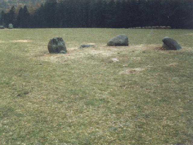
Sunday 19/5/02
Kinnell! It’s almost stopped lashing down- now a ‘pleasant’ drizzle, but black, black skies all around. I’ve been kindly granted permission to visit this circle despite the fact that there are cows and calves in the field- as long as I stay well away from them they shouldn’t have the urge to trample me to death! The woman at the massive Kinnell House was very charming and even thanked me for asking permission to visit the site- as always (well- nowadays anyway). The fact that there are ‘Danger-Bulls’ signs around the field kinda put me off. What was I saying about the rain? It’s started again with a vengeance. The circle, the stones, the rain. This is a beautifully preserved circle of six huge stones varying in height from about 2m to 1.2m graded towards the smallest stone at the NE. The stone next to this at the north bears about 4 cup marks on it’s inner face. I’m standing in the middle of the circle. The widest faces of all six stones are looking in on me. It feels oppressive (or perhaps it’s the weather). Here in the centre are a small group of stones, though these look like field clearance as the largest one is covered in plough scars. My pen and notepad are soaking and it’s becoming increasingly difficult to write. I guess it’s time for the elements and the stones to take over…
Update! Another four single cups/groups of cups have been found near this main group- check out the Ancient Lothian website for details/pics. Hope to re-visit soon and post pics/co-ords here. My guess is there are many more just waiting to be found...

24/10/85- okay, okay- so it’s a crappy pic, but hey- Disc cameras was where it was at in the mid 80’s. Will hopefully have some better pics soon...


Summer 1986- from the other side of the Tay showing the church atop the Mound at the head of Loch Tay


15/4/02-using my compass and his vast knowledge of Ancient Astronomies, Young Aed calculates the Summer Solstice alignments ;)


