


25/7/02- the arrows scratched into this delicate site- unfortunatley the cup and rings are almost worn away to nothing.

25/7/02- the rock with the 11 or so cups near the end of the ridge


16/6/02- with a ‘clootie’ or rag bush in the background. This is a recent phenomena- St. Anthony’s Well isn’t traditionally a clootie well.
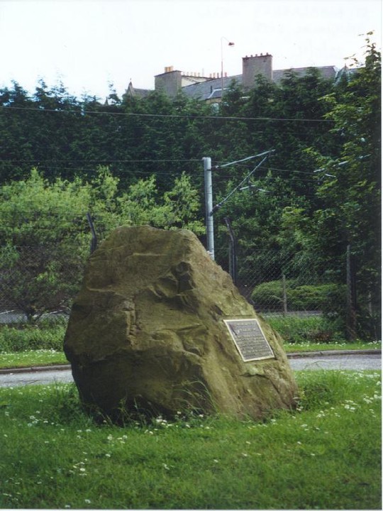
22/6/02- the *original* site in Meadowbank Stadium carpark marked by this boulder.

23/7/02- the mound in the main clearing basked in glorious sunlight. Images just don’t do the immense scale of this site justice- see for yourself.


23/7/02- the path that take you along the cursus between the mound and the ditches


24/7/02- the cliff face on which the carvings are situated (and the river you can wade to get to them!!!)
East Cult Standing Stones
27/7/02
A ridge rises out of the fertile plains of Eastern Perthshire to a height of 204 metres. The views stretch from the Sidlaws to the hills around Dunkeld and Birnam and up to Glenshee and the Grampians. Atop this ridge are the three stones of East Cult. They are aligned E/W and graded in height towards the west. This massive stone stands at 2.15 m with a circumference of over 4 m. Approximately 9 m to the east the next stone rises to a height of 1.8 m. A rounded side facing south, a flat northern side catches my gaze and points in the direction of a dip in the Dunkeld Hills over towards the Two-Poster at Newtyle and the cup and ring marked rocks of Birnam Hill. The third and final stone is the most interesting. This is a cup marked recumbent which is another beautiful viewfinder and interpreter. There are over 130 markings on this stone- it points my gaze to the north and aligns perfectly with Benachally Hill about 7 km away. This interpreter measures 1.25 m wide by 1.9 m long and slopes up from the ground to the south to a height of 0.9 m at it’s northern edge. The cups measure from approximately 3 cm to 12 cm in diameter. Along the western edge is a line of 11 cup marks all of which are about 3 cm in diameter. The black clouds to the west hang heavy in the sky, the sun almost breaks overhead. Whilst taking pictures I hear something coming towards me through the undergrowth- I look up to see a stoat looking up at me. It slowly checks me out, then heads back towards the middle stone. Wild roe deer are also sniffing amongst the thistles just to the south. The stones then draw my view to the dark clouds and black mass of Birnam Hill- the rain. Time to go. I stand and try to take it all in one more time- this is a hugely impressive site- in fact one of the most spectacular I have yet visited in this part of the land.
Cleaven Dyke Cursus
23/7/02
The Ordnance Survey get it wrong once again! The forest clearances are all in the wrong places and they manage to miss out a once tarmaced track, but map the route of a small path- hmmmmm. Travelling south on the A93 from Blairgowrie I stop at one of the small and very muddy lay-bys at the North Wood and then head roughly northwest along a track which according to the map runs along inside the Cleaven Dyke. However, these woods are fairly sparse and light and checking either side of the track doesn’t reveal much. I reach a crossroads in the woods and switch on my GPS to try and work out exactly where I am. I head south to where the cursus should be. Walking down through the trees a huge gap opens up on the right and that’ when the hair on the back of my neck stand up- o h m y g o d- I’ve read a bit about this site- how high it is, how long it is, but nothing prepares you for the sheer huge scale of this sacred monument. The mound itself is about 2 metres- there are bushes growing all along the ridge giving it a height of about 3 and a half metres! The whole monument including furrows, ditches and mound is about 60 metres! Standing next to the mound running way off in either direction I feel very humbled and very very small. It’s a glorious July evening and I start to walk the dead straight line of the cursus towards the dead ends. The sun beats down. I walk the line of the cursus. I walk the mound. I walk the ditches. I walk in the sun. I walk in the cursus:kursus:mursus:murmur:mu:mur:mu:ur.
It was thought that the actual stone was a ‘druidical stone’ which had toppled over.
Legend has it that the stone marks the final resting place of a suicide or murder victim. It has also been suggested that this is the grave of Macbeth.
The Long Man’s Grave
27/7/02
This time I simply have to see what this is- we’ve passed by this site on many an occasion but always in the car and have never managed to se anything as we whizz (or crawl!) past. We park up next to an old quarry and I jump the stile into the field and head off in search of the Long Man’s final resting place. Before I know it I’m opposite the entrance to Pitmiddle Wood. I must have gone past the grave but I’ve only walked about 200 m. I retrace my steps along the side of the field, but can’t see a thing apart from cow shit. I check the map again- the grave should be on the opposite side of the road from the trees (where I am) and halfway between the start of the wood and the track. It looks like it’s right next to the road so I leap the fence and almost leap onto the top of it- aha! A large stone slab. The grave of the Long Man at last! The reason I’ve not seen it from the car is that it’s level, if not, slightly below the tarmac. The stone slab is about 0.75 by 1.5 m although it’s difficult to judge due to the vegetation and a dry stane dyke running at the head of the stone. The slab is unmarked and looks a lot more ancient than I anticipated (it’s not marked in antiquarian font on the map). What an amazingly atmospheric place to be buried below the cliffs of Black Hill and Dunsinane.
St. Matthew’s Well, Roslin
24/7/02
According to a description I had of this well, it’s just over the west wall of a graveyard just down from Rosslyn Chapel. Checking the map and using the GPS, I head into the cemetery and down to the ruins of St. Matthew’s Chapel- not a lot survives- only two separate sections of wall standing about 2.5 metres high. To the left of these walls stands the gravestone of John Howie and just behind hi final resting place is a small step built into the cemetery wall taking you into the thick undergrowth on the other side as well as piles of rotting flowers etc. from recent burials and memorials- not a pleasant place. The terrain gets worse- rotting trees covered in every slimy insect you can think of and dense stinging nettles growing to over 2 metres high. It also doesn’t help that this is all on a slope of mud. Checking the map and GPS again I become aware of the fact that I am moving- both sinking into the mud and sliding down the hill. Grabbing some of the trees I manage to pull myself back up onto firmer ground. I stop and listen- I can hear running water through the dense vegetation. I manage to hack my way through the nettles and come across a small opening in the mud from which vigorously issues clear and cold water- is this all that remains of this once Holy Well? I head further into the nettles and come across two concrete half-cylindrical dome structures (each 1 m high by 1.49 m wide by 1.38m long and 1.1 m apart). Both of these have had iron doors at some point on their southern sides, but have been bricked in. However, the north dome has had the bricks smashed in- I stick my head in- cool, clear sacred water flowing down.
Glenballoch Four-Poster
AKA Craighall or Courthill
Sunday 28/7/02
As luck would have it, I ask permission to visit this four-poster at the fantastic old Saw Mill Cottage at Glenballoch. Through the amazing garden I meet the owner of the cottage who informs me that the farmer who owns the fields opposite lives somewhere in Perth. However, he adds that the farmer who rents the land has no objections to visitors to this site and the nearby standing stone. I leave him to his gardening whilst I head off in search of ancient astronomies. From the road the site is obvious as it’s on a huge mound and covered in nettles and thistles. I head up the small hill and carefully pick my way to the stones- a bad time to be wearing trekking sandals and three-quarter lengths! Whilst having a look around I hear the field gate opening below the mound and almost immediately I’m greeted by the Mill Cottage collie dog. It’s owner follows puffing on his pipe. We have another chat in the stones- this time about the meaning and placement of this site. He tells me he comes up to this stone circle regularly and often ponders its meaning. He goes on to say that his house gives him an excellent view of the sky all year round and he notes the position of the sun setting and rising with regards to the horizon. From here, Glenballoch standing stone is only about 200 m northeast and we agree that this site may have possibly been used as a calendar of agricultural activity. We have a very pleasant chat standing amongst these ancient stones- I tell him of another stone circle and standing stone which once stood on the hill above us until being destroyed in the 1950s. I mention the fact that I’ve visited this site before about 10 year ago and he’s keen to know if it has deteriorated in that time. Looking around us, I think it possibly has. There seems to be more field clearance stones- indeed the north stone is almost hidden under a pile, whilst there are some very large stones next to the western stone. The stone at the south seems to have more broken from it. Bit messy I’m afraid! The man and his dog bid their farewell leaving me with the stones. Despite the nettles, thistles and field clearance stones, this is still and enchanting and atmospheric place. I head northeast to the massive outlier…
Glenballoch Standing Stone
AKA Craighall or Glenballoch Cottage
28/7/02
Walking up to this monster monolith from the nearby stone circle, this stone simply dominates the horizon. It’s huge. 2.5 m high by a maximum of 2.6 m wide. Round on its east side, near the base, are six, possibly seven, cup marks- difficult to see as some of them have eroded over the centuries. However, there are four extremely deep (about 4 cm) marks set in a square- two 7 cm and two 5 cm diameter cups. It just seems so blatantly obvious to me that this is a representation of the circle seen from here only 200 m down the hill.
Friday 26/7/02
A return journey to this fantastically remote four-poster. We have a great walk up through the forest to this site- the views are great, the forest deserted (well- apart from the occasional vehicle marking out the trail for tomorrow’s rally- glad we decided to come up today). At the stones we have a bit of a picnic and now Aed’s walking he sets about exploring the stones for himself, though the bumpy ground ain’t really suited for size 5 baby feet! I leave them to eating and come into the circle. I lean back against one of the stones and it feels like my skull melts into the rock, it buzzes and tingles. When I eventually open my eyes it takes a minute or so for the colours and shapes of the earth and sky to return.
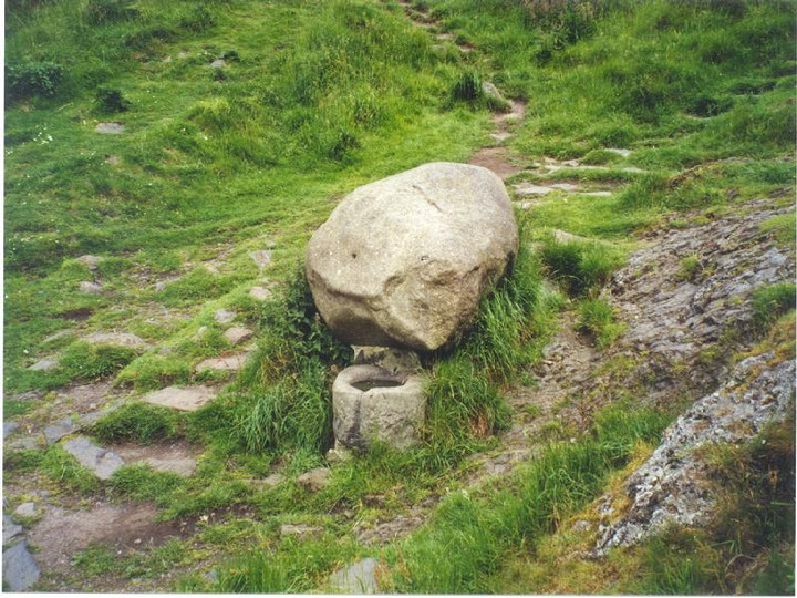
Birnam Hill Cup and Ring Marked Rocks
AKA Craig Ruenshin
25/7/02
Aed and I head off through the almost knee-deep heather and assorted vegetation leaving Kat and H-dog to head up to the top of Birnam Hill. The flies are almost unbearable up here and accompanied by the soaking humidity and rough terrain makes for a rather unpleasant journey. Along the way we disturb three very small roe deer. This ridge rises out from the gorse and heather. From the ridge we watch as tracks go sprinting through the gorse below us and suddenly a deer head appears barking obscenities at us before disappearing again- fantastic! According to the OS map there are three areas of cup and ring markings up here. I manage to find two- one is almost at the end of this ridge and comprises of about 11 cup markings with possibly two or three rings- it’s very hard to tell as this rock has weathered very badly. I’m trying to tread lightly on it where I have to as further boot erosion won’t help. I retrace my steps back along the ridge peering closely at all the rock surfaces. It is, however, not cup and ring markings I see first, but some dirty great big arrows scratched into the rock. Some complete idiot has seen fit to deface this ancient site to highlight to the fellow hard-of-thinking that there are a couple more cup and ring markings. I mean, for fucks sake, I was scared to walk on the ridge, but some arsehole has decided it’s okay to scratch arrows into the rock. I leave disgusted.
Heatheryhaugh Cup and Ring Marked Stone
AKA Mains of Creuchies
28/7/02
A massive boulder sits in the shadow of Parknuek and almost at the entrance to this field- 3 m long by 2.7 m wide. The westernmost face of the rock slopes down to the earth and on this face are approximately 15 cup markings- three of which possibly have single rings round them, though the surface is badly weathered making the markings very difficult to see.
Croft House Standing Stone (AKA Tulloch)
22/7/02
Yet another standing stone on the A924 Bridge of Cally to Pitlochry road- and one that I managed to miss out on my last visit that took in most of these monoliths. This triangular stone stands at the edge of the road high up on the verge.


15/4/02- the ramparts (Traprain Law and North Berwick Law in the distance)

15/4/02- the fantastic setting for this hill fort looking over the fertile plain of East Lothian with Traprain Law on the right.


