
The remains of the information sign
Image credit: Chance - Sep 2008

The remains of the information sign

La Grosse Pérotte and La Petite Pérotte are placed a mere 45m apart and should be grouped together. They have been built into a natural ridge. A broken part of the capstone, together with the remains of the information sign.

View from inside showing the uniformity of the supporting blocks and the precision of the building.

One of the few carvings I could clearly see.
A couple of names, one dated 1940 and above it another dated 1946.
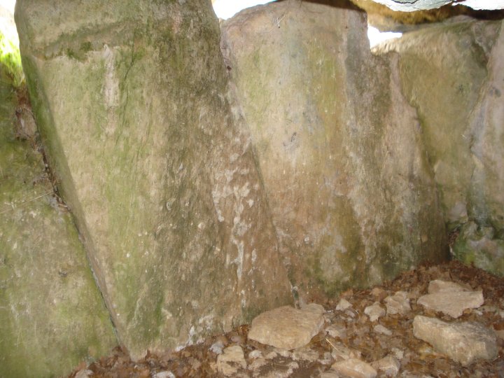
View from inside showing the way the whole monument appears to have moved sideways.

The English tourists showing the size of the Dolmans.

View from the back showing the way the whole monument appears to have moved sideways.


View from the back showing thickness of capstone and the way the whole monument appears to have moved sideways.
La Grosse Pérotte and La Petite Pérotte are placed a mere 45m apart and should be grouped together.
They have been built into a natural ridge a few kilometres SW of the village of Fontenille.
Easily spotted from the D.61, the stones are marked with the usual brown historic monument sign, “Dolmens”.
Parking is easy from the track which runs along the ridge. See the La Petite Pérotte site for more on access.
La Grosse Pérotte, which not surprising is the largest of the two, has a huge capstone, 5m square and 2.5m thick.
This capstone covers a rectangular chamber of approximately 3m by 4m which is lined with well chosen or dressed stone slabs.
Although both dolmans are in a ruinous state, La Grosse Pérotte seems to have been pushed to one side by a giant hand.
All the supporting stone slabs lean in the same direction and appears to be the result of seismic disturbance or subsidence.Perhaps the dolman was built above another, subterranean chamber or void, which has since collapsed in on itself.
The area around the mound is littered with half buried stones and it is difficult to tell where they would have originally fitted. Maybe there was an entrance passage or galleries of the main chamber which were covered by the mound.
A concrete plinth stands directly in front of La Grosse Pérotte, but it’s bronze information plaque has been ripped off and any details relating to the either chambers’ Neolithic carvings, obscured from the causal tourist or sight seer.
The area surrounding the ridge, were these dolmans sit, is covered with prehistoric mounds and it would be interesting to work out their interconnections. Traditionally the area was marsh and bog, making this ridge a natural island. Perhaps the draining of the land has caused or contributed to the subsidence. This region of France is know as the land of 1000 barrows and many of it’s modern descendants migrated to similar marshy, boggy lands, the Cajun of Louisiana for example, originated here.
Chance – Sep 2008

The beech trees planted by the Victorians, to turn it into more of a ‘folly’, have themselves become part of the Wayland Smithy experience.

The beech trees planted by the Victorians, to turn it into more of a ‘folly’, have themselves become part of the Wayland Smithy experience.

Looking into the mouth of the cave.
I wonder just how much of this stonework has been re-instated and how much has been placed here by the archaeologists’ imagination. The pictures of the barrow before excavation show an overgrown heap.

Gold coin produced by the local British tribe – the Artbates in the 1st Century BC.
Evidence of the Vale of the White Horse being a frontier zone comes from the distribution of such coins.
Wantage Museum

Unpolished flint axe from Alexander Keiller’s collection
Half way down the restored West Kennet Avenue, The inner (eastern) face of Stone 19b of the West Kennet Avenue bears near the base a group of small but typical marks of the kind thought to have been produced by the grinding and sharpening of flint or stone axes.
A few simple notes, on how to find this stone.
From the Red Lion pub, cross over the road to the Southern or Sun circle.
Walk up to the portal stones and follow the path to the right, close to the wire fence and the trees.
Take care on this stretch as the tree roots can be tricky under foot.
Look carefully and you will find the broken stump of Avenue Stone no.3. Go through the gate and watch for traffic as you cross the road.
Go through the gate and pass of Avenue stone No.4, The Bison.
Walk further down the Avenue, through the concrete plinths. You won’t reach any more sarsens until you get to Stones 13A and B. Count down the stones, 14A, 15 A and B. At number 16, the Avenue jumps into the road and 16A is buried beneath the asphalt, leaving 16B alone. Stones No.17A and B are gone for good but 18A sites right next to the fence, with the stump of 18B on the other side of the road. The Stone in front of you is now 19B. The inner face nearest the fence shows the polissoir marks, a hollowed out flat surface and several grooves.
Other items of intersest include part of a polished patch on Avenue Stone 32a, above the broken part on the damaged face and more diffuse smoothed areas also occur on Stones 24 and 31 of Avebury’s Outer Circle.
Smith, I. F., Windmill Hill and Avebury: Excavations by Alexander Keiller 1925-1939, London, OUP, 1965.
Section 5. ARTIFICIAL MARKINGS ON STONES – Page 223
Far more easy to find than the Polisher but lacking the ambience of the downs.
Chance

Axe Heads from Alexander Keiller’s personnel collection
One axe head made from knapped flint, with oak staff, the other a polished stone axe of the type created from a polisher stone similar to this.
For those who cannot find this site or cannot walk all the way up here, another although not so grand, polissoir surface can be seen on stone number 19B of the West Kennett Avenue.
As this stone is complete and in the upright position, its use as an axe grinder would have long ceased before it was incorporated into the Avenue
Posted by Neil Rigiani
Length of route: 13 km (8 mi)
Suitable for: Walking
“A circular walk that starts at Amesbury and includes a fantastic view of Stonehenge as you reach the brow of a hill. Almost no roads involved. ”
Haven’t walked this, but it looks straight forward enough. You could even visit the Friar Tuck too.

Stonehenge Twilight
Kodak Black and White Infra Red Film with Red R25 Filter
.

Lanhill Long Barrow showing the Ministry of Environment Bronze Plaque before it was stolen
Kodak Black and White Infra Red Film with Red R25 Filter

Walking up the old path to Silbury Hill
Kodak Black and White Infra Red Film with Red R25 Filter

Extract from the excavations made by the modern A345 in the 1970’s.
The two wooden henges, which now rest under the modern road, are shown, together with woodhenge and the round barrows south of it leading to the long barrow.

View looking North from between the old and modern A345. The henge covers all the area of the horizon, so you can see just how large an area it covers.

View looking East showing the modern A345 and hidden by the trees, the river Avon.
Note for all you eco-tourists: The bus stop shown is now the nearest public one to Stonehenge.

View looking North from between the old road and the current A345

View looking North from the old road showing the banks of the henge
Web site on Alexander Thom’s Megalithic yard with detailed plans of Woodhenge.
Digital reconstructions and fly throughs of Woodhenge

The Bronze plaque at the back of Woodhenge,
possibly installed by the Cunningham’s in the 1930’s,
shows the signs of age. Another plaque below it reads..
“Woodhenge so called because it was originally a
wooden structure of a type similar to Stonehenge,
was probably set up during the bronze age possibly
for a religious purpose. The concrete posts mark
the position of the original timbers, the 6 concentric
rings are indicated in the different colours on the plan.
The rings are oval, with the long axis pointing to the
rising sun on Midsummer Day. The red concrete
posts (which do not form part of any of the rings)
and a burial near the centre are shewn in
black on the plan. A bank with the ditch on
the inner side surrounded the monument which
was entered by a causeway on the North East.”

Stonehenge – emerging from the A344 underpass


Stonehenge car park looking west towards Fargo plantation and the A344.

Stonehenge with the A303 in the foreground.
If the tunnel had been built, this whole view would be one flat plain once more.

Looking towards Stonehenge from the Normington Down trackway

Coneybury Hill, site of the destroyed Coneybury Henge to the right, with the A303 to the left


The Cove looking south eastwards to Norris’ Farm in 1922

Orchard Farm stone wall.
These stones were rescued from the floor of a local barn. The building was refurbished into living accomadation and the floor of the old cow shed was dug up. The barn dates from the time the Sanctuarty was broken up and lies at the back of Overton Hill, in the grounds of East Kennet Manor.
Their size and bulk would fit those drawn by William Stukeley in his “Prospect of the temple on Overton Hill – 8th July 1723” from his publication, Abury – A Temple of the British Druids
It would appear lots of sarsen’s have found their way into this wall

Orchard Farm stone wall.
These stones were rescued from the floor of a local barn. The building was refurbished into living accomadation and the floor of the old cow shed was dug up. The barn dates from the time the Sanctuarty was broken up and lies at the back of Overton Hill, in the grounds of East Kennet Manor.
Their size and bulk would fit those drawn by William Stukeley in his “Prospect of the temple on Overton Hill – 8th July 1723” from his publication, Abury – A Temple of the British Druids
It would appear lots of sarsen’s have found their way into this wall

View looking across the inner circle with the post holes from Phase I to III.
This picture shows the central pillar to the right, the stone-and-post ring and the outer circle towards the entrance to the Avenue.

The odd stone set back from the rest of the inner circle.

The place where two worlds merged.
This marks the spot where they found “the lad”, as the Sir Arthur Keith refered to him.
“All parts of the human skeleton are present, the bones being of a lad about 14 years of age and about five feet in height. ..... The skull view from above shows an oval form. All the features of the skull and skeleton lead me to regard the lad as a member of the long barrow people.”

This is the overall size of the Sanctuary.
The concrete pillar at the bottom of the picture marks the centre of the site and the second band of cut grass marks the outer circle of 42 stones, 60 feet away.
The access gate leads to the A4 layby and the barrows of Overton Hill.

Looking out of the Sancturary towards the stile and NT foot path south east.
The blue concrete blocks mark the outer circle. Stukley stated that the circles formed ovals or egg shapes, but they were found to be 2 stone circles within a group 7 deep stone and wood layers. The outer measures 130 feet in dia. and contained 42 stones.

These concrete blocks painted blue, mark the excavated holes made formed by the two stone circles and outline stones. These were installed by the Cunninghams when they gave the site to the nation, after their excavations in 1930. They could be nearly 80 years old.

The size of the Sanctuary can be judged here by the circles cut in the grass.
The access gate from the A4 layby and the Ridgeway, with the round barrows of Overton Hill, in the background.
This shot shows the two odd stones leading off the Avenue stones to the left. (See the ground plan for a clearer view of this.) This feature may have been the exit if you were to process around, or could have been the entrance used by the high priest, once everybody else had assembled. There is also a single odd stone shown opposite this. The plan seems to show the stones turned 90 degrees to the circle, so forming another entrance/exit.

Looking into the Sancturary from the NT foot path. The Blue concrete posts mark the excavated position of stones. With the grass cut around the inner circle, the size of the structure can be gauged. The EH information board can be seen towards the hedge.
Behind the hedge line runs the ancient Ridgeway, the offical start, lies over the road (A4) at Overton Hill.

Plan 2
This is a more detailed mono graphic ground plan of the inner circle of wooden post holes.
The Cunningtons broke the site down into 7 rings. Here the outer ring, which contained only stones has been excluded. Ring C – The Stone-and-post ring had 32 holes in total, but only half of these were wooden post holes, the other half, the stone holes, being made later.
Here are the number of holes and thier diameters, as recoded by the Cunninghams in 1930.
B – The Fence ring of 34 stake holes, 65 ft in dia.
C – The Stone-and-post ring, 32 holes, 45 ft in dia.
D – The Bank Holiday ring, 12 holes, 34 1/2 ft in dia.
E – 10 foot ring, 8 holes, 21 ft dia.
F – 7 foot ring, 8 holes, 15 ft dia.
G – 6 foot ring, 6 holes, 13 ft dia.
The legend shows the various phases of construction from I to III. The stones were all erected much later, maybe after the sight had gone into decline through warfare, deisease or migration.
The position of the sole grave, that of the “lad”, is marked in the east.
