
South side of Silver Barrow showing extensive damage caused by the badger setts.
Image credit: Chance - Dec 2007

South side of Silver Barrow showing extensive damage caused by the badger setts.

View of the valley looking towards Old Ditch
Longbarrow and White Barrow .
The oppidum of Alésia is one of the most famous archaeological sites in France, but until recent years it was suffering from its lack of visibility and from the small surface of the museum in Alise-Sainte-Reine. A large part of the 7000 hectares (oppidum and Cesar’s fortifications) is covered by a forest that makes difficult to understand the site.
The council of the French department of Côte d’Or, to whom the site belongs, decided to change this situation in 2004 and launched a big programme to build an open air archaeological park
The Bernard Tschumi Architects Agency won the project with an ambitious plan: a synergy between History and Landscape will help visitors to understand successively the besieger and the besieged points of view and to discover the different cultures that occupied the site during the first centuries A.D. The future park is divided in two parts:
- The Besieger Interpretation Center and a partial reconstruction of the roman fortified lines will introduce the Gallic War.
- The museum of Gallic civilization, the « excavation area », and the base of archaeological operations will explain more generally the human occupation of the site.
With a gradual opening that should begin in 2010, Alésia’s Park will be the biggest archaeological park of Europe and will give back to the site the recognition it deserves.
To find out more, contact the society in charge :
SEM Alésia – 25 bis, rue du Rochon – 21150 ALISE-SAINTE-REINE / Tel : 0033 (0)3 80 96 96 23
Website : alesia.com/
(Camille Daval – ArchéoMédia, March 2008)
For animations of the Alésia MuséoParc see:
youtube.com/watch?v=fg9KvdzzjGg
Download the English translation pdf at alesia.com/ fic_bdd/pdf_fr_fichier/11990978440_anglais.pdf

Roman coin showing head Of Captive Gaul 48 BCE stuck after the Gallic Wars
As many as a million people (probably 1 in 4 of the Gauls) died, another million were enslaved, 300 tribes were subjugated and 800 cities were destroyed during the Gallic Wars.
The entire population of the city of Avaricum (Bourges) (40,000 in all) were slaughtered.
During Julius Caesar’s campaign against the Helvetii (present-day Switzerland) approximately 60% of the tribe was destroyed, and another 20% was taken into slavery.
see
en.wikipedia.org/wiki/File:RomanSilverDenariusWithHeadOfCaptiveGaul48BCE.JPG
The battle and siege of Alesia is considered one of Caesar’s greatest military achievements, and is still one of the classic examples of siege warfare and circumvallation.
For more information on this and Caesar’s campaigns see Wikipedia
Alésia – Where and What – en.wikipedia.org
Where is Alésia?
France, Bourgogne, départ. Côte-d’Or (21), Alise-Sainte-Reine
The uncertainty surrounding Alesia’s location is humorously parodied in the Asterix volume Asterix and the Chieftain’s Shield, in which, in this case because of Gaulish pride, characters repeatedly deny that they know its location (“I don’t know where Alesia is! No one knows where Alesia is!“).
There have been archeological excavations since the time of Napoléon III in Alise-Sainte-Reine in Côte d’Or near Dijon, which have claimed that the historical Alesia is located there.
New discoveries are constantly being made about this Gallo-Roman settlement on the plateau of Mont-Auxois.
As a result of the excavations, a find was presented to the museum there with the inscription: IN ALISIIA, which finally dispelled all doubts.
What was Alésia?
Alesia was the capital of the Mandubii, one of the Gaulish tribes allied with the mighty Aedui, and after Julius Caesar’s conquest it became a Roman town (Oppidum) in Gaul.
In September, 52 BC it became the legendary site of The Battle of Alesia or Siege of Alesia
This was fought by the army of the Roman Republic commanded by Julius Caesar, aided by cavalry commanders Mark Antony, Titus Labienus and Gaius Trebonius, against a confederation of Gallic tribes united under the leadership of Vercingetorix of the Averni, and was the last major engagement between Gauls and Romans, marking the turning point of the Gallic Wars in favour of Rome.
The siege of Alesia is considered one of Caesar’s greatest military achievements, and is still one of the classic examples of siege warfare and circumvallation.
As many as a million people (probably 1 in 4 of the Gauls) died, another million were enslaved, 300 tribes were subjugated and 800 cities were destroyed during the Gallic Wars.
The entire population of the city of Avaricum (Bourges) (40,000 in all) were slaughtered.
During Julius Caesar’s campaign against the Helvetii (present-day Switzerland) approximately 60% of the tribe was destroyed, and another 20% was taken into slavery.

Plan of Bibracte showing the topography of the site with the plateau du Couvent, the inner and outer ramparts and the boundaries of départements, Nièvre (58) and Saône-et-Loire (71)
Source – en.wikipedia.org/wiki/File:Plan_Bibracte-fr.svg
Bibracte was the capital of the Aedui tribe and one of the most important hillforts in ancient Gaul.
Bibracte was built on Mont Beuvray which straddles the borders of the French départements of Nièvre (58) and Saône-et-Loire (71) and lies 25 kilometres from the city of Autun in Burgundy.
A few decades after the Roman conquest of Gaul, Bibracte was abandoned in favour of Autun and without a continuous settlement to disturb the site, Bibracte remained for modern archaeology to rediscover.
The first excavations were begun by the wine merchant Gabriel Bulliot between 1867 and 1895. His nephew Joseph Déchelette, author of the famous Manuel d’Archéologie, continued the excavations between 1897 and 1907.
The site is an archaeological park at the centre of a protected forest, and a site of cooperative European archaeological efforts, a training ground for young archaeologists as well as a centre for interpreting Gaulish culture for a popular audience.
Important international excavations have taken place at Mont Beuvray, with teams from the universities of Sheffield, Kiel, Budapest, Vienna and Leipzig.
Oppidum (plural oppida) was the name used by Caesar to describe the Celtic towns that he discovered during his conquest of Gaul.
In archaeology, the term is now used to describe all fortified Celtic sites covering a minimum area of 15ha and dating back to the second half of the 2nd and 1st centuries BC (the late La Tène period).
These towns were both economic and political centres. They are considered to be the first towns to the north of the Alps.
This website offers you the opportunity to find out more about each of the oppida via information sheets. For more information, click on an oppidum or go to the themed exhibitions…
For more on Julius Caesar’s conquest of Gaul in the Gallic Wars, 58 BC to 51 BC.
See en.wikipedia.org/wiki/Gallic_War for more info on this period of European History
The Aedui were one of the most powerful tribes in Gaul and before Caesar’s time, had attached themselves to the Romans, and were honoured with the title of brothers and kinsmen of the Roman people.
In 63 BC, when the Sequani, their neighbours on the other side of the river Arar, with whom they were continually quarrelling, invaded their territory and subjugated them with the assistance of a Germanic chieftain named Ariovistus, the Aedui sent Diviciacus, the druid, to Rome to appeal to the senate for help.
Although Diviciacus’ mission to Rome was unsuccessful, his diplomatic and political skills, along with his friendship with Julius Caesar, marked the beginnings of Rome’s military invasion and ultimate conquest of Gaul.
In 58 BC, when the Helvetii began their ill fated march out of their tribal homelands and through the territory of the Aedui, they were defeated 16 miles south of the fort by the armies of Julius Caesar. For helping Rome, Caesar restored the independence of the Aedui.
In spite of this, the Aedui joined the Gallic coalition against Caesar and in 52 BC, Vercingetorix was proclaimed its leader at Bibracte.
After the surrender of Vercingetorix at the battle of Alesia, the Aedui reverted back to their allegiance with Rome.
Diviciacus welcomed the victorious Julius Caesar back to Bibracte and witnessed Caesar complete dictating his masterpiece, The Gallic Wars.
After the death of Julius Caesar, the Emperor Augustus dismantled Bibracte and built a new town 25 kilometres to the east with a half-Roman, half-Gaulish name of Augustodunum, which we know today as the modern city of Autun.

Little Avebury Stone Circle with the Ridgeway in the background

Looking south towards the Packway with army traffic

Some features remain but the site is much disturbed

Bumps in the ground and an outer bank – Looking North

When I first visited this site I spoke to an old lady in the other church, just over the spring in Alton Barnes. She called this stone “The Maiden Stone” and then added, some say “The Virgin Stone”. It who be interesting to know if it has ever been properly examined. Maybe it’s the remains of a handfasting or oath stone like the one Stukeley saw at Avebury

The 1,700 year-old yew tree in the churchyard. Two trees have formed from one.
Got a big fertility vibe out of the whole site.

Plan of the central Stone Structure at Stonehenge as it survives today.
Stone numbers are those conventionally used in the recent literature and following Petrie, F. 1880. Stone types are shown as sarsen or blue stone. The ref. to sandstone is for the Alter stone, No.80

Stonehenge Plan showing the different features of the sight and their positions
1 = The Altar Stone, a six ton monolith of green micaceous sandstone from Wales
2 = barrow without a burial
3 = “barrows” (without burials)
4 = the fallen Slaughter Stone, 4.9 metres long
5 = the Heel Stone
6 = two of originally four Station Stones
7 = ditch
8 = inner bank
9 = outer bank
10 = The Avenue, a parallel pair of ditches and banks leading 3 km to the River Avon
11 = ring of 30 pits called the Y Holes
12 = ring of 30 pits called the Z Holes
13 = circle of 56 pits, known as the Aubrey holes
14 = smaller southern entrance
The plan omits the trilithon lintels for clarity. Holes that no longer, or never, contained stones are shown as open circles and stones visible today are shown coloured, grey for sarsen and blue for the imported stone, mainly bluestone.

View looking towards Alfred’s Castle from the edge of the cemetery

View of the interlocking ditches made out in cow parsley.

View looking across Idstone Down from the top of the middle barrow. Ashdown house can be seen on the right. On the far right lies the access track by the medieval farm house. The track on the far left is a bridle way which runs through the middle of the cemetery.

Close up of the curious marks on the Cove Stone.
Created by the roots of palm trees or are they the marker lines for astrological events?

The cove viewed from the East looking West showing the curious marks either left by the roots of palm trees or by the creators of Avebury. If this stone was one of the first erected, than did the same people leave their mark?

Detail from the ceiling mural in the pool room of the Barge at Honeystreet showing Picked Hill.
This mural by Vince Palmer features Wiltshire’s ancient monuments – Stonehenge, Avebury and Silbury Hill – woven together with circles, triangles and swirls that have been spotted the fields nearby.
See themodernantiquarian.com/facility/50
or web site the-barge-inn.com/index.htm

Croppy Central
Map of the Avebury area on the wall of the Barge at Honeystreet. Each dot represents a crop circle and the colour shows the year it happened. Great pub to explore See themodernantiquarian.com/facility/50
or web site the-barge-inn.com/index.htm

Detail from Vince Palmers’ ceiling mural in the pool room of the Barge at Honeystreet showing Avebury looking south. See themodernantiquarian.com/facility/50 for directions.

Detail showing the mortice from the fallen lintel of stone 156

The dressing of the sarsens seems to have been carried out in several stages of increasing delicacy.
Initially, the rough and irregular surface appears to have been reduced by working parallel grooves about 9 ins. wide and 2 to 3 inches deep, generally running longitudinally, using the larger mauls of 20 to 30 Ibs. in weight.
Examples of tooling left in this state can be seen on the upper (outer) face of stone 59 as shown above and on the lower part of the outer face of stone 54

View of the Eastern bank with the new golf buggy track

View showing the area leading up to the clubhouse


View of the northern area showing the much reduced pillow mounds

View of the new golf buggy track as it descends into the Western banks.
This is the area contain the main bailey and is very overgrown

View of the Eastern bank with the new golf buggy track

Field Notes
Castle Combe Hillfort – July 16th 2008
Rhiannon writes “An Iron Age promontory fort which later became a Norman motte and bailey castle”.
Well one things for sure, this site has been re-used for many purposes over many time periods.
Right now it’s part of the Manor House Hotel & Golf Club. Their web site proudly boasts
“The history of the grounds of Manor House date back to the Doomsday Book, second only to Stonehenge in terms of archaeological significance in Wiltshire.”
manorhousegolf.co.uk/EXCLUSIVE_HOTELS/the_club/history.aspx
I remember visiting this site back in 1985, prior to it being re-landscaped into the golf course. It lies very close to Lugbury long barrow and the Roman Fosse Way. It was very overgrown and difficult to work out. In size the area of the hillfort/castle is comparable with Oliver’s Castle on Roundway Hill but the trees and undergrowth camouflage it very well. It felt and looked ancient and the By Brooke, with it’s stepping stones and medieval looking bridge gave it an atmosphere of long lost England.
Maybe that’s why it was chosen as a film set for Robin Hood (the 80’s TV version) for a mock village had been created on the opposite bank of the By Brooke. Scenes from the 1967 film Dr.Dolittle were also shot in and around Castle Combe.
When I visited it in July 08, I came in via the foot path from Nettleton Mill, which is now path of the Macmillan Way. Most of the golfers had retired to the club house for their G+T’s and I was able to get onto the private track which runs along side and up the hill of the monument. The remaining area which is most likely to be Iron Age is still covered in dense overgrowth and difficult to explore. I have posted some of the pictures taken that day but it is hard to gauge what are ancient mounds and the modern landscaped bunkers of the golf course.
The site has never been properly excavated although there have been several “investigations” made at various points by Chippenham College under the supervision of Ron Wilcox. Various pillow mounds are present both behind the monument and within what was the Italianate garden of Castle Combe park. Again sketchy notes based upon OS field visits which list “Possible round barrow or ornamental feature”. Mesolithic tools have been found to the East, along with Neolithic scrapers and axe heads during excavations at the Shrine of Apollo at Nettleton Shrub (SMR Number ST87NW302). Finds from the area itself include iron arrowheads, spurs, buckle heads and the odd coin or two. A circular stone wall deep underneath the North Western corner of the driving range was detected and Romano-British pottery fragments which were uncovered near the Clubhouse.
An interesting site to explore, if for nothing more than a walk in a beautiful landscape.
Bear in mind that the monument is on a private section of the golf course though and those low flying golf balls can kill.
Chance – July 2008

The remains of a subterranean chamber perhaps? Ideal den for a fox

View from the top looking down the track towards La Grosse Pérotte and the vandalised information post

View from side showing one of the areas of stone removed.

View from inside showing what may have been a pet’s grave.

View from side showing one of the areas of stone removed.

View from side showing thickness of capstone and one of the areas of stone removed.
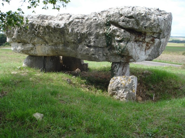
View from side showing distance from the road


Natural cracking of the stone and one of the areas of stone removed with an industrial saw

View from side showing position of the capstone above the mound

View from side showing thickness of capstone and one of the areas of stone removed.
La Petite Pérotte and La Grosse Pérotte are placed a mere 45m apart and should be grouped together.
They have been built into a natural ridge a few kilometres SW of the village of Fontenille.
Easily spotted from the D.61, the stones are marked with the usual brown historic monument sign, “Dolmens”.
Parking is easy from the track which runs along the ridge and although this would had led to them being well known, it might have also lead to their apparent vandalism.
La Petite Pérotte lies about 800m SW of the D.61 and is the first monument reached.
A huge capstone about 5m in length, 3m wide and 2m thick, rests on several supporting stones.
This all sits on top of a small earthen mound, which when viewed from the East, seems to contain a sunken chamber.
The supporting stones had either been chosen or shaped to form a purposefully square chamber below the capstone.
These supporting stones have clearly been disturbed in recent times, either in the course of archaeological investigation or as I would suspect, archaeological treasure hunters. A concrete plinth stands by La Grosse Pérotte, but it’s bronze information plaque has been ripped off and any details relating to the either chambers’ Neolithic carvings, obscured from the causal tourist or sight seer. I counted at least three areas an industrial stone cutter had been employed. It would be nice to think that whatever had been removed had found it’s way into a local museum, but cultural vandalism seems more likely. Maybe Egyptians getting their own back on the children of Napoleon.
The Dolmens may have lost part of their magic and mystery, but the planting of Oak trees around their confines has imparted an air of tranquillity and peace to a much disturbed site.
Chance – Sep 2008

