

The ‘Prehistoric linear boundary’ (or Cross Ridge Dyke in old money).
Easily spottable from the bowl barrow (just to the SE) despite the trees.


The Bowl Barrow viewed from the foot path, facing East (ish)

A view of Wolstonbury Hilltop enclosures taken from the cross ridge dyke.

Chanctonbury Ring in the sunshine, viewed from the South Downs Way to the SE.
(Cursuswalkers pic is from the other side of the Ring)

The view east from the shade of the remaining beech trees on the southern bank.

Peering into the raided center of the barrow, looking SE towards Brighton and the coast

Wolstonbury Bowl Barrow viewed from the eastern section of the cross ridge dyke

A deer breaks cover from behind one of the north flanking barrows. Or is it a barrow wight?!


Atop the bank looking east, wooded round barrow at the end


Culliford Tree Barrow, viewed from the North

High Rocks, looking south into the area of mesolithic shelter. Stairs on left are modern!

A photo from the 20’s, looking west. This is when the site was only partly overlaid by allotments and paths, prior to it’s wholesale mash up during the 30’s, 50’s 60’s and 90’s by greedy bastard property developers. It is now largely covered by a notorious housing estate.

Aerial photo looking NW, across the northern escarpement of the Downs into the Weald.

A photo looking SE taken in 1928. I think she (the hill) looks particularly curvy and sexy from this angle, the dew pond making a perfect navel. Phwoar!
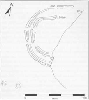
Plan of the enclosure as revealed by excavation and surface survey. The eastern part of the site has been removed by the quarry. The two barrows are shown to the SW.


looking SW from the edge of the cliff, towards the bowl barrows and reservoir

A view from the bowl barrows, across the site of the enclosure, facing NE.

Bit of a dark photo, but you get an idea of the damage wrought by the flint mining by the pitting of the ground. Facing South.


Another view of western bank and inner ditch. West Hill and Newtimber Hill in background.

Looking south west Wolstonbury outer enclosure.


Hollingbury from the West, showing West entrance

This is taken from a golf tee on the side of the Kitchen Midden to the West of the ruin.

Looking into ruined tower from the East. As you can see it is very overgrown compared to the old illustrations.

