
Close-up of one of the two distinct cup marks in the vertical face of a boulder below the cave. This appears to link the cave to the Neolithic.
Image credit: rockandy
Close-up of one of the two distinct cup marks in the vertical face of a boulder below the cave. This appears to link the cave to the Neolithic.


The NE coast of Jura. View S from the cliffs below An Carn.


Detail of weathering of a cup-mark which has been cut through the rock strata producing a pronounced rippling effect on the rock surface probably eccentuated by the effects of ice.


View of SW’most panel to the W, towards trees planted in early 1900s through which runs a stream and is the site of a corn-drying kiln

SW’most panel which bears 29 cup marks of varying size. The largest are 90mm diameter and 55mm deep

View to the S showing proximity of cup-marked panels to ruined houses of the An Carn township.


Emerged from the forest at last but for how long and still not easy to find.


View from near the cup-marked outcrop to the E over Keils to the islands of Small Isles Bay and the headland of Ardfernal with Knapdale in the distance over the Sound of Jura.

Close-up of one of the large, pristine cup-marks near the base of the outcrop on the vertical face. It is about 10cm in diameter and the same in depth.

View to N with the cup-marked outcrop centre left. One of the Paps of Jura and Corra Bheinn can just be seen above the intervening hills.

View of the outcrop from E. Highly eroded cups can just be seen on the upper surface and larger cups near the ground surface below.

Probable weathered cup mark at base of SE face.


Almost as good a name as Snook Bank.
Visited this site today with David and found it with the help of Stan’s slide photo in the Archive taken in 1993. Maybe noone has seen it since then! It was too cold for hanging about and after a short look round we headed home for a late breakfast.
The rounded, cup-marked boulder commands a fine view over the valley to the N and E. There are several large cups, some with possible faint rings and grooves running down the rock surface and there are two more cups on one edge.
Another cup-marked rock, Crocky’s Heugh b, is apparently in the same area but we didn’t find it this visit. The Archive describes it as a massive rock table in a quarry. There are many small quarries all over these slopes and a large amount of stone has been removed from the area.

Similar view to the one in the Beckensall Archive. It was a great help in finding the rock without an accurate position.

Several quite large cups, some with apparent rings, but all very eroded. Also shallow grooves on the surface and two cups on the SW edge below the heather.
From KeysToThePast site number N4227:
A natural rock outcrop overlies a rock shelter that contains evidence of prehistoric activity. An excavation there in 1975 discovered Mesolithic flints and an Early Bronze Age cremation in a pottery vessel. In addition the upper surface of the shelter is decorated with a carved basin and a groove, markings that are probably associated with nearby cup and ring marked stones. The shelter also seems to have been used in more recent times as post-medieval clay pipes, glass, pieces of iron and ledges carved in the rock were also found.
A good place to sit out of the wind with good views and the skylarks learning again how to sing as they think the winter may be over. Now, where did I drop my clay pipe?

Cup-marked rock in a difficult position on the E of the path from Caller Crags to Snook Bank. The W side has been quarried, the surface is covered with pine needles and the E side overgrown with heather and dense trees.

The Beckensall archive records about 50 cups of various sizes, some with partial rings. The rock surface had been brushed when I visited providing yet another example of human disturbance to Northumberland rock-art sites. I couldn’t relate anything in my poor photo to Stan’s illustration (but that’s always a trouble I have).

Caller Crag c. Cup-marked “standing stone” described in the Beckensall archive as having a minimum of 5 cups. If this surface is a consequence of both natural erosion and artificial carving, the effect is certainly stunning, as is its location above the crags.
More cups occur on the flat rock surface directly behind the stone (Caller Crag d) but were difficult to see. The site is about 150m NE of site a (well illustrated in the photos by rockartuk).

The dramatic, elephantine skyline of Caller Crags from the W. The cup-marked outcrop (site a; illustrated by rockartuk) is above the main cliff line to the right.

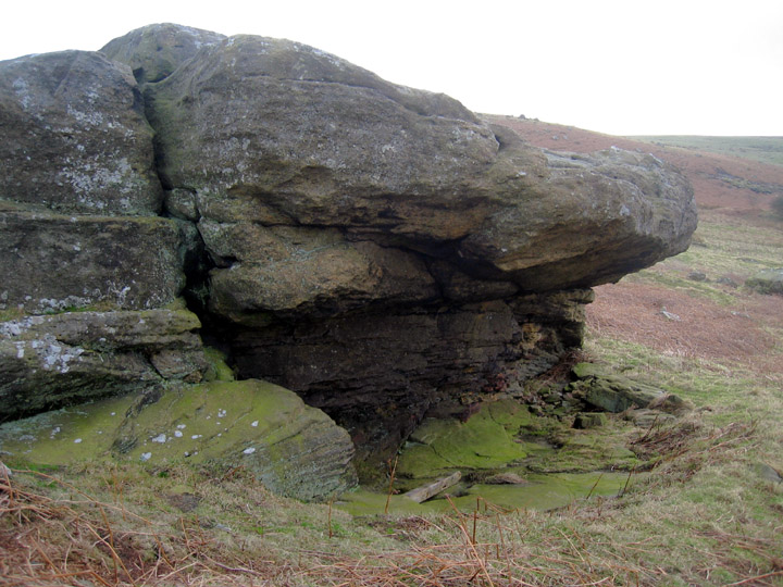
Large basin and grooves (probably formed by natural erosion) on the roof of the shelter. View NW over Iron Age settlement, below in trees, towards Wooler and The Cheviots.

View of the rock shelter from one of the standing stones on the slope below.

I’m sure Iron Age hillforts have their interest and like many in Northumberland the location is often stunning, as it was here. The many-walled fort was probably built more for show than for defense and may have been visible from some distance.
Similar to the Doddington Ringses, there is also traces here of man’s earlier use of the landscape by the finding of rock-art.
Two panels were found in the region of the fort in the 1860s and moved to Alnwick Castle Museum. They are illustrated by Stan Beckensall (2001 p166) who also shows the earlier drawings of Collingwood Bruce.
Apart from a rock slab given in the Beckensall archive as Beanley Moor 1, most of the carved rock now present in the landscape appear to be of the unimpressive cup-marked variety. They are certainly quite challenging to find, and even harder to interpret!
I’m certain there are more out there but there are alot of rocks to examine and in this game the light is not always perfect.

The Ringses interpretation board with the Camp behind.

Beanley Moor 7. Strikingly carved stone about 100 x 50cm, almost hidden in vegetation.

Beanley Moor 4. View SE from cup-marked boulder which lies in a small valley close to a prominent tree.

Beanley Moor 3. View NE from cup-marked rock outcrop.

Beanley Moor 3. Cup marked outcrop near to the top of a knoll, E of The Ringses.

Beanley Moor 2. Cup marked boulder built into a boundary wall just W of Ringses Camp, visible beyond.

The Ringses Camp, Beanley Moor. View NW up the valley of the River Till with the escarpment of Bewick and Harehope rising up on the right hand side.
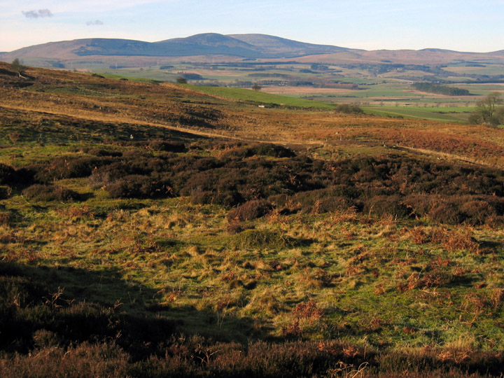
The Ringses Camp, Beanley Moor. View W to Cheviot.

The Ringses Camp, Beanley Moor. View NE towards Eglingham, the ramparts of the Camp in the foreground to the right.

Hunterheugh 1. View SW from the outcrop towards the Settlement. Cup-marked rock and large quarried slabs visible in the foreground. Trees on the slopes of Titlington Pike are prominent in the distance.

Hunterheugh 1. Landscape view to the SSE of the excavated outcrop. The Bronze Age burial cist was located in a fissure created by movement of large quarried, cup-marked slabs in the centre of the outcrop. A dispersed cairn was removed during the excavation. Cup and ring motifs are visible on the nearer rock surfaces.