
Destruction of the deep heather by fire reveals two cairns. The larger cairn has been much disturbed and stones removed to build a small shelter on the edge of the cairn along with a circular wall, probably an animal pen.
Image credit: Rockandy
Destruction of the deep heather by fire reveals two cairns. The larger cairn has been much disturbed and stones removed to build a small shelter on the edge of the cairn along with a circular wall, probably an animal pen.


View NE towards cairn – site of Ray-Sunnyside i; the deep surrounding ditch of a rectangular ‘enclosure’ is in the foreground. This has been interpreted as a Roman-period native farmstead (Sunnyside near Ferneyrigg).


Ray-Sunnyside j; located close to a cairn; view to SW


Ray-Sunnyside i; a single deep cup; rock closely associated with a cairn and ‘the end stone of a burial cist, facing inward’.


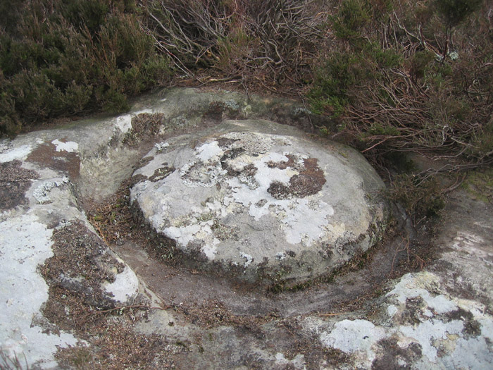
Ray-Sunniside a; cup-marked rock close to large cairn; view E

Ray-Sunniside a; cup-marked rock close to large cairn

Not fully convinced that this is Ray-Sunniside a; but it does look like a cup-marked rock and lies close to the same disturbed cairn.


View W with the outcrop just to the left of the pond and Titlington Pike rising up behind the forests above the farm.

View W. Two parallel veins divide the rock into two parts. Cup and rings are on a horizontal part of the outcrop to the right of the prominent vein, adjacent to the centre turfed island. Other cups (some of which are probably artificial) are found between the two veins and to their left.

View from the outcrop S showing one of the millstone rough-outs.

View of the outcrop to the north over the shooting pond towards the forestry plantations of Beanley Moss.

Cup (and faint shadow of a ring?) on the SE edge.


Two cups with highly eroded rings, a groove and other cups on the NE side of the outcrop.

1.5m diameter millstone rough-outs on the west side of the outcrop.

Hunterheugh 1; eroded motifs and enhanced basin with clear peck marks.


Another view (from vertically above) of one of the large carved stones in the Settlement area. There has been millstone extraction from part of Hunterheugh Crags nearby (there are some broken fragments) and locals interpret these too as millstones. Could they instead be the base of large in situ querns? The huge slab this carving is on may have been moved to its current position as rabbits have partly burrowed underneath.

Hunterheugh Crags (on left) and settlement area (on right) from W.

Hunterheugh 8a; view N towards Hunterheugh Crags. Eroded cup & groove are just right of marker.

Cup-marked and massively-quarried outcrop; view to W. Eroded probable cups are found on the main slab and on the small detached rock below.

Cup-marked and massively-quarried outcrop; view to E. Main part of outcrop facing the camera has a possible cup and ring obscured by lichen.

Hunterheugh 8b; view N to Hunterheugh Crags
Second large carved rock in settlement area

Hunterheugh 9; stone with cup-marked surface was set up vertically at the left hand side of the entrance to the Romano-British enclosure. One of the large carved rock ‘millstones’ is reached through this entrance.

Hunterheugh 9; stone with cup-marked vertical surface at entrance to Romano-British enclosure.

Small cup-marked portable among remains of possible cairn near Hunterheugh 6; view to W.

Small cup-marked portable among remains of possible cairn near Hunterheugh 6. Peck marks are visible in the crude cups and grooves in the normally turf-covered part.

Hunterheugh 6; View of Hunterheugh Crags to the E


Hunterheugh 6; cup-marked outcrop, view of Hunterheugh Crags to the E. The outcrop to the right, behind the main one, is surrounded by a rough, boulder enclosure.

Kimmer Lough (E of Hunterheugh Crags). Site of Bronze Age cairns (and Hob’s standing stone??).

Hunterheugh 3; motifs are highly eroded and difficult to see. Best wet in oblique sun-light.

Hunterheugh 3; View of panel to the W. The boulders above are the remains of one of the many old field boundaries. Titlington Pike is the far hill with fine views further west to Cheviot.


A second new cup and ring marked boulder near the forest boundary