

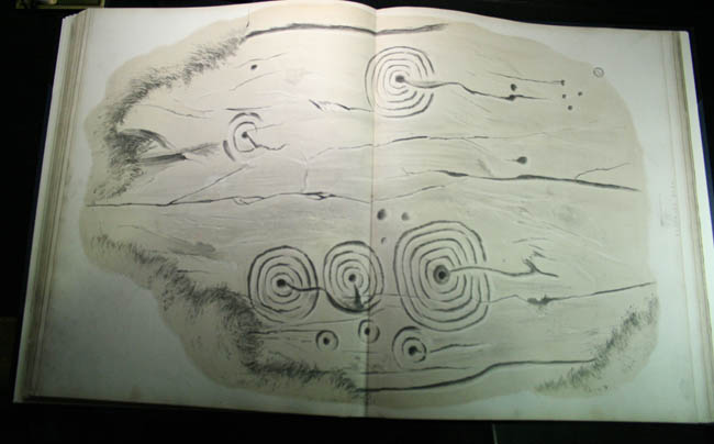
From ‘Antiquities, Historical and Monumental, of the County of Cornwall’ 2nd Ed. (1769)

From ‘Antiquities, Historical and Monumental, of the County of Cornwall’ 2nd Ed. (1769)
(I think I’ve put this in the right place...)

From ‘Antiquities, Historical and Monumental, of the County of Cornwall’ 2nd Ed. (1769)
Almost totally obscured by the heather, this is a stumpy little stone but definitely a standing stone, and seemingly prehistoric. It has packing stones and is heavily grooved on top, it’s also next to what look very much like disturbed cairns. Is about 120cm tall, rectangular in section, no apparent cupmarks. Similar to (and actually larger than, believe it or not) other small stones of Northumberland, such as that at Rothbury. They used to call them ‘Stob Stones’ in these parts, a stob being the stump of a tree.
This might be a new discovery, I’m not sure. Possibly it’s the one mentioned by Beckensall in prehistoric Northumberland, though I think it’s further south. His description would seem to fit better with this one photographed by Rockandy. Alternatively, this could be the stone mentioned on the Keys to the Past website but if so, their grid ref is waaaaay out, over a kilometre in fact. I Find it a bit baffling that their grid ref was originally only 4 digits, as it’s placed right on NU160110, down in the Titlington Burn. The OS do report a couple of stones in the area, but don’t give then the gravitas of the antiquity script. I’ve not seen either, so wouldn’t want to comment.
Should anyone want to give it the once-over, Garmin E-trex said: NU 12357 17161 (82m altitude, 4m accuracy)
There’s also a weird stone with cortical texture nearby, reminiscent of the one at Cuthbert’s Cave
Hunterheugh 2 is one of the finest panels of rock art in Northumberland. The motifs aren’t anything special, but the way in which you can see the effects of weathering are superb. I can’t think of many other places, with the possible exception of the frieze at Buttony where a single motif has been partially covered so that the viewer can see quite clearly what effects the years have on these kind of carvngs.
With Hunterheugh 2, the largest motif is almost completely worn away at the top, but fresh as the day it was pecked at the bottom. It relly improves appreciation of the other simple carvings in the area, as they have mostly been weathered to virtually nothing, but panel 2 shows what all the others must have looked like when they were fresh. For this reason, it is imperative that the turf must always be replaced to protect the fresh carvings.
Panel 3 on the other hand, is barely discernable. It’s only a couple of metres away from panel 2, but presumably has always been exposed to the elements. It’s so worn away, you would be forgiven for walking right past it without noticing a thing.
No much to see here, overgrown with tall heather, very disturbed, but definitely cairns. There’s a little rectangle carved into a stone on the north side of the northern cairn. Looks like it was made with metal tools, no idea how old. Possibly some kind of boundary marker thing.
Supposedly there’s a cist in one of them. I couldn’t find it amongst the rubble and heather. Couldn’t make out any kerbs either, but they’re so overgrown with heather, there may be kerbstones hidden.
There may be marked stones in there somewhere, maybe even marked bedrock, similar to those found beneath the excavated cairn at Hunterheugh 1 further up the crags.


Notes originally posted in 2004, then reposted after site was taken from TMA by he who did originally post it’s presence, then edited after a 3rd revisit on Nov 02 2007, this time with a bunch of veteran D&NRAPers. What a faff.
Despite what I’ve written below, closer inspection showed that this does look like outcrop.
There are also signs of quarrying, though by whom, who knows. it may have even been those pesky romans, who went around snaffling other people’s sandstone for their gaudy Mithraic temples etc.
Irregardless of who did the quarrying, it is interesting to wonder why they stopped before they’d broken up the whole bit of outcrop.
Imagination, given a bit of free-rein, suggests that this may have been because the ‘significant’ nature of the cupmarks was recognised, as is seen on many other marked outcrops in the county.
or, it may have been a deliberate act of desecration, with the remaining few cups being left as a reminder of what had been done. In which case, perhaps the original outcrop was much larger, maybe with more, wonderfully complex motifs (as opposed to a handful of fairly ropey cups...).
This speculation in turn leads to the idea that it may have been a case of prehistoric reverence, that a part of the marked stone was taken to serve as part of one of the many cairns in the area, or maybe even one of the cists, as is also seen with marked rocks elsewhere in Northumberland.
But, when it comes down to it, it’s more than likely that the stone was quarried to provide material for the nearby limekilns. Why did the quarrying stop before the whole stone was removed? Well, if I were some 18th/19thC dude repairing what was possibly an old roman limekiln, I’d only quarry as much as I needed, no more. What’s the point of going through the effort of breaking and transporting stones you don’t need?
Possibly the same cup-marked stone originally added to the county SMR by a keen cup-spotter, but then largely overlooked (like most of the prehistoric remains close to Hadrian’s Wall), this erratic boulder is fairly conspicuous, it’s the only one in the enclosed field, more or less in the middle of what is marked on the OS map as ‘Davy’s Lee’. I’m not sure if it’s the thing recorded on the Beckensall Archive, as that had a grid ref which placed it in a nearby stream, and was listed as being on outcrop. There’s no outcrop in the stream and there’s more than the 6 cups related on both the Archive and on the Northumberland county SMR, so ambiguity prevails.
It has natural grooves, which seem to have deermined the placement of the cups to some degree, as they are in groups, each group in an a part of the surface defined by the grooves.
The enclosed field in which the stone sits is interesting in it’s own right, as the boundary is a low earthen bank, containing what looks like cord rig. The banks are more pronounced at the NW corner, where a ditch is also in evidence, possibly part of a settlement?
Like most of the pre-roman remains in the vicinity, I’d argue this stone may have some connection with the stupendous stone at Queen’s crags.
Access:
Ask permission at the gatehouse, or at Sewingshields Farm. Rough, boggy terrain unsuitable for wheelchairs.

The easternmost of the currently recorded Hunterheugh motifs, Hunterheugh 4 is a set of faint cups with single rings. These are recorded on the Beckensall Archive as such. It’s not easy to say if there are 3 or 4 C&Rs as they are quite worn away.
There’s another single cup a couple of metres away to the NE, next to what looks like a natural feature that’s been enhanced into a shallow basin.
The other possibly significant thing about this site is the way the line of C&Rs seem to point to the peculiar natural feature of Cloudy Crags on Aydon moor to the south.

Looks like an enhanced natural feature to me. Single cup mark top right.

The C&Rs are in the background, the single cup and the possibly enhanced basin in the foreground.

Hunterheugh 4, detail of the most prominent C&R.

Very eroded. Blink and you miss ‘em.

This set of C&Rs on panel 1 echo the arrangement of the motifs at Hunterheugh 4, or maybe it’s the other way round.

Cup mark a couple of metres north of the markings listed on the Beckensall Archive. Next to a natural (enhnaced?) shallow basin.

02-03-07
Panel 1 visible in the background.
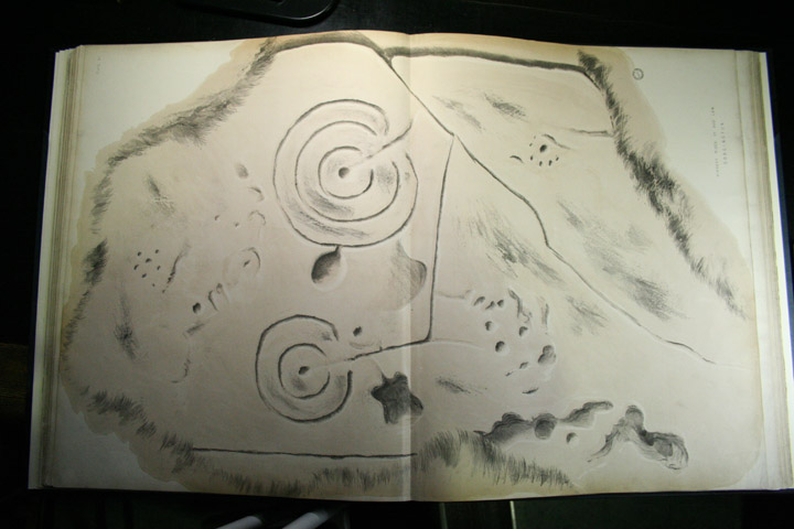
From ‘Incised rocks...‘
Interesting to note he’s missed out the groove that links the two larger motifs.


View down the Tyne valley to the SW, past Corbridge, over Hexham way. The stone isn’t in it’s original position, but probably came from pretty close by, with more or less the same view.

Thornborough High Barns in the background.
As seen in the monumental tome ‘Incised Markings On Stone‘
(It’s a big book, each page is A1 and I’m afraid I couldn’t photoshop the pagefold out!)

From ‘Incised Markings On Stone’, from the days when this site was known as Weetwood Bank.

From ‘Incised Markings On Stone’, from the days when this site was known as Weetwood Bank.
Re-visited 25-02-07
This little marked stone is more or less exactly where akas555 reports it, on the south side of the field boundary. (Garmin e-trex says NZ019648 when rounded up from 10 figures). It looks like a very old boundary, with the remains of a bank, mostly quite low, but giving the impression that it may have once been quite substantial, with traces of hedge in places. The absence of undergrowth shows there are oodles of field clearance stones in the bank, making me wonder if there are any other carvings still hidden from view. The marked stone is quite obviously no longer in situ, but presumably came from somewhere fairly close. Maybe there was once a cairn in one of the fields, or I suppose it may have been part of an inconvenient (from a farmers point of view) lump of outcrop. The former seems more likely.
I spent a very uncomfortable afternoon in high summer a couple of years ago looking for it on the wrong side of the fence, which is festooned with brambles and nettles. I was searching on the north side of the fence, further east towards Brockhole dean, which is where it appears to be when using the ref given on the Beckensall Archive. So near, yet so far...
I feel a revisit armed with akas555’s info and a gps would be in order.
Details and photo of the incised stone.

Currently lives in the Museum of Scotland in Edinburgh.

Close up of a carved spiral from a chambered tomb, showing the peck marks.


There’s a decent view behind the trees.
In Northumberland’s Prehistoric Rock Carvings (Pendulum, 1983), Beckensall says ‘The site is very unusual at the side of a stream, and does not command the usual extensive views’, this is closely tied in with his Zen-like statement in Prehistoric Rock Art in Northumberland (Tempus, 2001), when he adds as a caption on the photograph on p.119, “This flat boulder is either in it’s natural position, or has been brought there”. I’d agree that it seems to be in an incongruous setting, but noticed that when approached from the east, you can see above the treeline and there’s a superb view over to Cheviot, framed by the two nearest hills. This argues to it being in situ.
However, when you’re at the boulder itself, there’s a profusion of field clearance stones, all of which are either small cobbles, or medium sized bits about the right size for a Northumbrian kerb cairn. So there’s the possibility that the marked stone came from a now defunct cairn. The area drips with funerary remains.
Adding to the ambiguity is the fact that the stones seems to lie smack bang on a prehistoric trackway, complete with standing stones, cists etc., which supports either viewpoint. I just couldn’t make my mind up completely.

Lithograph of Old Bewick 2, taken from The Proceedings of the Berwickshire Naturalists Club


As seen in ‘Inscribed Rocks...’ 1865.

As seen in ‘Inscribed Rocks...’ 1865.


