|
|
I visited last year - the paths to the stones have been "shut" by whoever "owns" the land.
|

|
Torrisholme Barrow was the old Law Hill of the Lancaster area, superceded by them building a whopping great big castle on the omphalos South of the Lune. But this was the original burial place of the ancestors. Old maps show a Low Lane running north from Torrisholme and to the West of the Barrow and ending up at Treason Fields, where the rail line now runs.
The natural mound has an ancient groove running around the Eastern edge right round to the north and then up the hill driving South. As this part is ascended Warton Crag can be seen to the North and Black Combe rises to the West. Sometime between 1844 and 1919 the Morecambe Corporation built a Sanitorium here and traces of the foundations can be found in a the woods that block the path here. Climbing up through the woods eventually brings you to the end of another old path, called Barrow Lane. The houses have encroached right up onto the hill but the paths are still here in parts, running behing the gardens of the quiet suburban semis.
Continuing South brings you to a groove running up from the West, where the houses are, and this groove runs up to the top of the hill and the tumulus. By this stage the whole of Morecambe Bay is beginning to be visible and following the groove brings you over the crest of the hill looking East and you get quite a psychological thwack through the front of yer face to the back, like, with the sight that greets you (the unmistakable crest of Ingleborough in the distance, which dominates the Lune Valley). Hurray!
It is really worth getting up here on a good clear day and making this route, rather than just going straight to the top of the mound over the stile from Hexham lane at the South, and taking in the view (360 degrees of it, which includes the missing-pixel-like power statement at Heysham, whoops).
Also a very unusual perspective is got of the Llancaster omphalos (where they built the castle and priory) and the ur-temple mound (now quarried) upon which stands bigus dickus of one Mr Williamson (thank you kind sir). But hey. If you want a bit of the reverse - seeing the barrow from a distance - a good place to go is Williamson's park and the barrow is the first rise of land to the right of Lancaster.
But it is Torrisholme Barrow which would have been the Law Hill of more ancient origin, calling in the authority of the sacred hills that surround it.
|

|
 
|

|

|
 
|

|
|
After going to see Discover Odin on 4th/ 5th Oct 2001, British Museum there's another state of affairs. The king stone is the World Tree and the nine stones either side represent the nine moons that Odin hangs on the World Tree looking for answers/ powers.
|
It is reckoned that these settlements, of which there are many in Penwith, were training centers or initiation centres. Most of them are near or contain a fogou and are always situated near to a sacred hill, a quoit, a stone circle and a holy well. So it seems that each community had it's own set of tools as it were. Unfortunatly the fogou at Carn Euny is the least impressive in Penwith as far as it's feel goes. Probably because parts of it are missing, though the main passage seems complete.
However the whole complex of Carn Euny is very impressive - the largest 'room's shape is well worth checking out. Also notice how there is a ruined dwelling from a later period tacked on the edges of the settlement which has a very different feel to it ie. it is square. A nice compare and contrast - 'brighten the corners'!
|
|
Go into the quoit - it's a must. It's often reckoned that quoits were once covered in soil, which would make them a bit like the fogou's but with Chun it has such a wonderful vantage point to watch the sun rise and set from within (with gaps in just the right positions) that I would think that no-soil is the supossed state of affairs. So quite a stellar perspective then.
|
|
Another 2 ditched hill fort, like Faugen and Chun Castle, but totally overgrown with trees. Some nice trees though. Again some tip top views and a half and a good start out of Penzance to get an alternative view of the surrounding country.
|
|
Most of the tracks marked on maps are completely overgrown in Penwith and quite unusable without a scythe, which I don't usually carry aound with me myself. This is a bi-vallette hillfort; it has 2 ditches (it says on the nice sign at the gate) and dates, so is reckoned, from around 500BC- 0AD and would have belonged to a local chief. I only found the inner ditch/wall to be discernable and it is quite a search to find a way in. Two standing stones stand in the NE of the round a bit like gateposts and if you look though them to the SW St Buryan church tower can be clearly seen and if you look NE through them Penzance Parish church can be seen. Funny that. And indeed the view up here is utterly choice. A good place for a fort maybe but also a good place to be on top of the world watching the sun rise and the sun set and the moon glide over the sea.
|
|
A note on the 19 stone type scenario that is so common in Penwith. I've heard tell that each one of these circles has a 'sun' stone or 'king' stone (quartz and set in the West it seems to me). Two crecents of nine stones representing waxing and waning moon and triple goddess type scenarios (virgin, mother, crone) advance on the sun/king stone. Some kind of ceremony. Hmmmm.
|
|
Carn Kenidjack strikes such a distinctive pose in such a bold way that is visible from so many points around Penwith that really you'd be rude not to make the effort to go there and spend a little time. I sat with a friend for hours there with the sun up above and a little doggy having a great time. Up above all the heavy stuff at this seriously heavy place. Good views of the sea to the North and the three hills of Carn Brea, Bartinne Castle and Caer Bran to the South. Wonderful outcrop to park in on. And from there ya can see, just, the little rig of tiny, humble stones that are the Tregeseal Dancing Stones which are just a simple delight, darling. Wow. Very, very nice indeed. 19 stones, like most round here. There are a couple of outlying stones visible from the circle towards Kenidjack, but they could just be 'normal' stones, it's a bit difficult to tell.
|
|
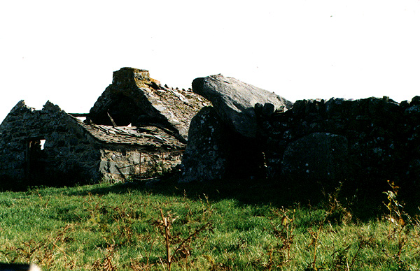
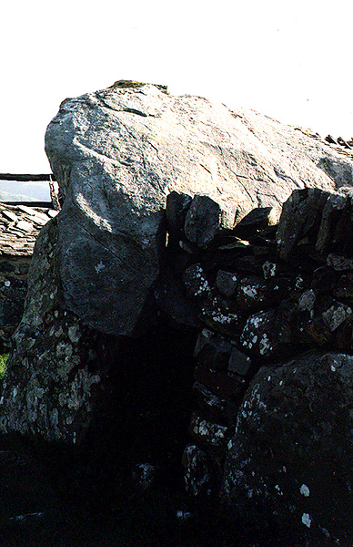
You know all that dungeons and dragons stuff? Well this could be fogous and ferpents. This place is huge. I thought it would go on for ever, like sum kind of Khazad-dum. Unfortunatly there's a new set of metal braces holding up the roof near the entrance, but don't let that put you off. A must, must.
|
It took me while to round asking the woman at the garage whether the inconspicuous clump of gorse in the field behind her whole filling station was where the 3 brothers were residing. She said that they were out on the moor, which apparantly meant yes. And then I had gorse and heather to wade through for about 200 yards in sandals. Ouch!
The stones lie looking a little like a dolmen/quoite, in that one of them caps the other two, but I suspect that this is not their original state. It kind of looks like they've been dumped unceremoniously in a field, though that may be to fool such fools as me. Going on the name I think of the 3 brothers N of Lancaster and so imagine them standing seperatly. The surrounding land and sea is not dissimilar to Morecambe Bay either. There is a ruined chapel nearby in the NE of the field.
|
|
There is a car park just to the side of Carn Brea, in between that and Bartine Castle and most people take this route to the top which is probably the most boring one to take, a bit like going up Snowdon via the railway. The way I prefer to go is to take a footpath from a place called Brea on the B3306, near the airfield and so walk up from the West (although I guess that it might be good to come down that way after the sun has set too) thereby taking in two standing stones at the bottom of the hill, set close to each other, not unlike gateposts (see also Faugen Round). It's also quite good fun making it up this way because of the maze like gorse.
|
This site gets pretty busy, especially in summer. I've been there a few times in the past couple of weeks and it's always got a steady stream of tourists visiting it, people jogging through it and all that kind of thing. I always find that when I first see them on approach I get butterflys in me stummick. It is a great place and SPACE. Also it's a good place to see the local landscape as the three hills of Carn Brea, Cear Bran and Bartinney Castle are all visible from here and the line from these through Boscowan-un and into Lamorna valley can be viewed.
The second to last time I was here I experienced a very dramatic weather change - very low cloud or mist or something swept in in a matter of minutes and completely obscured the view, like the site was being hidden. Then later it left almost as quickly.
|
|
Wouldn't this place be a great place to do your rock'n'roll! What a space! ! Go to other white horses near by Devizes way and compare the geological similarities. Like a big bowl of vibrational energies. As for the hill fort - what were they guarding? Treasure? Food? hmm -perhaps they weren't really guarding anything after all. And the chalk mound where St George slew the dragon. hmm internal dragons? Looks a little like Silbury doesn't it.
|
Read 'Fogou: A Journey into the Underworld" by Jo May
ISBN 0 906362 34 2
Gothic Image Publications
|
|
Yes well powerlines ahoy! Like Roman Roads these things are. Funny that int it. Well this site is without a doubt a must see if you are anywhere near it at all. Don't expect to get your car up the road though unless it has a big engine or thirty five wheels. The hill is of the lovely steep variety so common in N Clwyd. YHA accom at the top (Rowan) which I gather is mostly used by people visiting these stones (though when I visited it was being refurbished so I could only read about it). Nice floor growth later in the year. Beautiful views when chin is lifted.
|
|
I couldn't get into the church when I visited back in the summer of '99. Reflections of you in the waterfall. The Llanbedr stones are nearby though in a flat field. My travelling companion of the time listened to the stones for several minutes and said that she heard the stones tell her some stories. She's Krautrock. Very nice and YHA accomodations nearby too if ya fancy.
|
|
If you do have trouble finding the stones the surrounding woods are beautiful to walk through with many big boulders that look like you might think these rocking stones would, especially as the picture in the MD is now kind of out of date. Most of the foilage around the stones has been cut away and so when you find them u'll know. Just found a site in the Cornwall section also called the 3 brothers. Any connection??? I'll go find out!
|
|
Check out the crow action round this one! The circle is positioned in the center of a circle of hills with a breach and long view opposite the 'entrance' to the circle. In the distance is a wind farm and behind you is the farmers farm. Looking at this view there's a hill to the right quite close by that takes about 10 minutes or so to climb and has a trig point at the top. You get a really good view of the circle in relation to the natural bowl formed by the surrounding hills and the wind whips its wings through here - loads of crows getting off on that. Having a great time they are. The circle itself is close knit, though some of the stones are diminished or toppled. Great place and well worth a visit.
|
I think it was 1993 got into Jehovakill and Peggy Suicide late one night before driving to Blackpool from Hest Bank for a flight in a small plane. Became aware of stones and stuff when about 10, maybe earlier, on family holidays. Have lived in penal Wankfaster most of my life cept for a spell in Penwith for a couple of years. Do music of the rock'n'roll variety, one time dry green. Like dancing now. Have had four mega-trips. Wales, Outer Hebrides, Dorset to Cirencester and JC, GZM, DT&2PB to Penwith {shipwreck}.
|
|