Psst. The eagles might have been deposited 1000 years after the tomb was built, according to this piece in British Archaeology. It probably doesn’t matter.

Rhiannon
Article from November/December 2005:
“Ireland’s road network is experiencing an astonishing development, with sometimes controversial implications for the country’s rich and largely unexplored rural heritage. Dàire O’Rourke, senior archaeologist at the National Roads Authority, says a new code means everyone will benefit.”
“This hoard was found in a pit dug into the top of an oval cairn. The burial cairn, constructed of limestone rubble, was first opened by A.D. Conyngham in 1848. Surviving records suggest that the hoard was found with a burial. The surviving finds comprise three flint axes and a flint adze, five lozenge-shaped arrowheads, a polished flint knife and two flakes, an antler ‘macehead’ and two boar-tusk blades.”
Various photos of the hoard online here.
Dowsing Gogmagog – by WA Clark. Article and pictures about Lethbridge’s exploration of the site.
Links to the notes from the meetings of the Thornborough Henges Consultation and Working Group over the last couple of years.
Article about the two amateur archaeologists, Mr Mutch and Mr Durbidge, whose discoveries at Pakefield in Suffolk led to the known date of arrival of early humans in northern Europe being pushed back by 200,000 years (to 700,000 years ago). Bravo!
An engraving of a man on a woolly rhinoceros bone found in Pin Hole Cave – thought to be from the upper Palaeolithic, 12,000 years ago. Though whether it’s truly from this cave or not is another matter (see misc posts).
A 10,000 year old decorated horse jaw, found by Thomas Kendrick in the cave in 1880. It’s “the only piece of artwork dated to the end of the last Ice Age or Late Glacial period in Britain”. It’s all zig-zaggy and I rather like it.
A decorated weaving comb from the Iron Age, made from an antler, and found at Danebury.
A photo of the complete beaker found in West Kennett. Complete!!
Picture of a ‘toe ring’ from the Iron Age found at the camp. Another at
wiltshireheritage.org.uk/galleries/index.php?Action=4&obID=183&prevID=87&oprevID=13
Please ask them rather than me how they knew it was a toe ring and not something else.
The museum’s new website showcases the fantastic articles from the Bush Barrow burial.
Aerial photos of the fort.
“The Barrow at Portskewet.”
Sketch by William Henry Greene
6 May 1893
Online at ‘Newport Past’, along with his many other local sketches, courtesy of Pontypool Museum and sponsor Steve Thomas.
Circle on the Grey Hill.
Sketch by William Henry Greene
Around 1893.
Also see newportpast.com/gallery/whgreene/others/s2722a.htm
Online at ‘Newport Past’, along with his many other local sketches, courtesy of Pontypool Museum and sponsor Steve Thomas.
“The Bromlech at Faes-Llwyd.”
Sketch by William Henry Greene
12 May 1893
Judging by Mike Murray’s photo, Gaer Llwyd must be the ‘bromlech’ to which Greene refers.
Online at ‘Newport Past’, along with his many other local sketches, courtesy of Pontypool Museum and sponsor Steve Thomas.
“Twmbarlwm Camp – the Pimple.
Sketch by William Henry Greene
Around 1892.”
Online at ‘Newport Past’, along with his many other local sketches, courtesy of Pontypool Museum and sponsor Steve Thomas.
“Fort Tredegar from Tredegar Park” Newport Mon
Sketch by William Henry Greene
16th June 1892
Online at ‘Newport Past’, along with his many other local sketches, courtesy of Pontypool Museum and sponsor Steve Thomas.
The earthworks of this fort are now apparently complicated by those of a defunct golf course, according to Coflein.
“Coed y Dafryd Camp from Tredegar Park, Newport, Mon.”
Sketch by William Henry Greene
23rd June 1892
Online at ‘Newport Past’, along with his many other local sketches, courtesy of Pontypool Museum and sponsor Steve Thomas.
“The Cromlech at Gwern-y Cleppa near Newport, Mon.”
Sketch by William Henry Greene
12 May 1893
Online at ‘Newport Past’, along with his many other local sketches, courtesy of Pontypool Museum and sponsor Steve Thomas.
Chapter one of Peter Ackroyd’s ‘London: the biography’ – which is full of information about prehistoric London, including a bit of etymology of its hills and rivers, with plenty of interesting things to chase up.
Photo by Bob Embleton.
Looks a bit sorry for itself. But if it’s a replacement, why would you replace a stone with this? It also seems to be one of Alfred ‘Ley’ Watkins’s ‘mark stones’, which might confer a dubious air, but then we do have the (presumably, but not necessarily older) folklore.
John Piper’s screenprint of the stones (1978).
A print by Henry Moore, ‘Stonehenge III’ (1973).
A pencil /watercolour called ‘The Vale of the White Horse’ (circa 1939), by Eric Ravilious.
Photo of the howe by Paul Allison.
A photo of the cairn, which is apparently one of the largest in Northumberland.
A photo of the hill by Pete Glastonbury, as part of his ‘Wansdyke Panoramic Tour’.
Thomas Hardy set his short story ‘What the Shepherd Saw’ at the Devil’s Den (or the Devil’s Door, as he called it).
“To the south, in the direction of the young shepherd’s idle gaze, there rose one conspicuous object above the uniform moonlit plateau, and only one. It was a Druidical trilithon, consisting of three oblong stones in the form of a doorway, two on end, and one across as a lintel. Each stone had been worn, scratched, washed, nibbled, split, and otherwise attacked by ten thousand different weathers; but now the blocks looked shapely and little the worse for wear, so beautifully were they silvered over by the light of the moon.”
The WW1 poet Charles Hamilton Sorley (only 20 when he died) wrote this poem about Barbury Castle.
Richard Jefferies wrote about Liddington Castle in his ‘Story of My Heart’ – and you may concur with his sentiments.
“By the time I had reached the summit I had entirely forgotten the petty circumstances and the annoyances of existence. I felt myself, myself.”
An aerial photo of one of the cairns.
The Merlin’s Hill Centre have designed nature trails that lead you up onto the fort. Also, choose ‘Merlin’ from their index for a drawing of the fort in the Iron Age complete with pointy roundhouses, and the river winding through the valley below.
Lots of information about the five day September fair that used to be held inside Woodbury fort – the largest in southern England, attracting thousands of visitors each day and drawing traders from as far afield as Birmingham, Norwich, Exeter, Bristol and London. It is known to have already existed in the 1200s and continued until the middle of the 20th century.
Website about the valley of the River Foulness in East Yorkshire since the Old Stone Age – but mostly about Iron Age times, when it was home to one of Britain’s oldest and largest prehistoric iron industries. You can choose the depth of information you want (basic/intermediate/research) on the front page.
As you will know if you’ve been following David Dimbleby’s ‘Picture of Britain’, the composer John Ireland found great inspiration in the landscape of Chanctonbury Ring and Harrow Hill: his ‘Legend’ was written whilst wandering here. In his final years he lived in a windmill overlooking the Ring.
Carved into the broken standing stone third clockwise from the north-west causeway entrance are some Norse ‘twig’ runes. Interesting reuse of the site or just ‘I was ere’ tourist graffiti? They haven’t been satisfactorily translated, so who knows.
Canmore gives a photo of which stone to look out for:
rcahms.gov.uk/pls/portal/newcanmore.p_coll_details?p_arcnumlink=345588
The 1982 Department of the Environment Guide Book for Stoney Littleton, with many interesting facts, and including the excellent inscription unexcellently cemented to the tomb:
THIS TUMULUS, -DECLARED BY COMPETENT JUDGES TO BE THE MOST PERFECT SPECIMEN OF CELTIC ANTIQUITY STILL EXISTING IN GREAT BRITAIN HAVING BEEN MUCH INJURED BY THE LAPSE OF TIME, – OR THE CARELESSNESS OF FORMER PROPRIETORS, WAS RESTORED IN 1858 BY MR T. R. JOLIFFE, THE LORD OF THE HUNDRED; THE DESIGN OF THE ORIGINAL STRUCTURE BEING PRESERVED, AS FAR AS POSSIBLE, WITH SCRUPULOUS – EXACTNESS.
[link broken]
A comprehensive list of the scheduled monuments in Purbeck.
Sketches of the stones by the excellent John Piper (1903-1992).
An early drawing of the stones by Henry Gyles (c1640-1709).
A drawing of the stones by William Daniell (1769-1837), who took an artistic ‘Voyage Round Great Britain’.
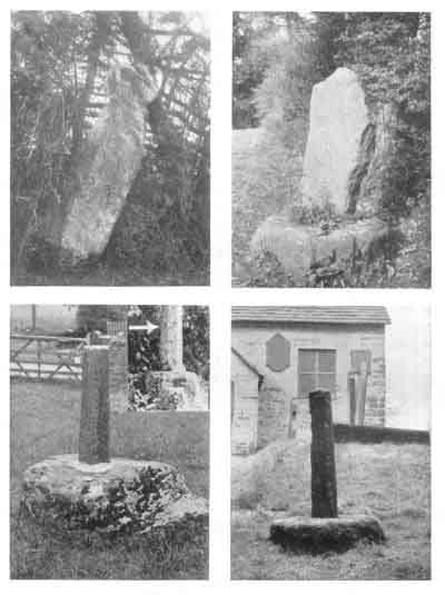
Alfred Watkins thought the Wergins Stone (top right in the picture) was an ancient marker, the flat face pointing out the direction of a ‘ley’. This photo is part of his ‘Early British Trackways’ book, online at the Sacred Texts archive.
Graeme C interprets the very rare runes on the Lemmington Wood stone, and mentions that until at least the 1930s people poured milk into the cup marks in spring to ensure their cows would produce milk through the summer.
A green hill long ago
Article on Silbury and The Options to stop it falling in, in the latest online copy of British Archaeology magazine.
Strange experiences at Glenquickan circle.
Maps and information about this vitrified fort, the burnt timbers of which were dated to between 400 and 600 BC.
David Staveley’s article on the yew forest and the folklore of the area.
A concise history of Alton Priors by John Chandler, which points out among other things
- that the Ridgeway passes ludicrously close by (check out a 1:25000 OS map),
- the reasons for there being two churches almost next to each other,
- and that the bumps in the field are probably the remains of the village which has since shrunk (not barrows, I’m afraid, as notjamesbond suggests above)
Photo of two axes found at Cwm Mawr / Corndon Hill.