
Open Source Environment agency LIDAR
Image credit: © Environment Agency copyright and/or database right 2015.
Open Source Environment agency LIDAR
Image contained in the middle of the “East Midlands Research framework wiki: Chapter 4 The Neolithic and Early to Middle Bronze Age”
(main page link archaeologydataservice.ac.uk/researchframeworks/eastmidlands/wiki/Eastmid4)

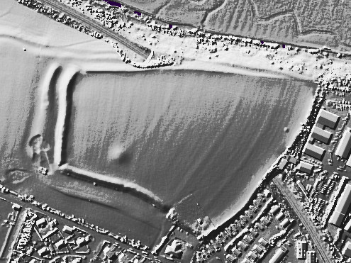
Open Source Environment agency LIDAR
Hard to see, but if you use the ground plan I’ve linked, you can just make out the cursus going through the central field.
Half way down this page is a ground plan showing the path of the cursus.

Open Source Environment agency LIDAR

Open Source Environment agency LIDAR

Open Source Environment agency LIDAR

Open Source Environment agency LIDAR

Open Source Environment agency LIDAR

Open Source Environment agency LIDAR

Open Source Environment agency LIDAR

Open Source Environment agency LIDAR

Open Source Environment agency LIDAR

Open Source Environment agency LIDAR

Open Source Environment agency LIDAR

Open Source Environment agency LIDAR

Open Source Environment agency LIDAR
Open Source Environment agency LIDAR

Open Source Environment agency LIDAR

Open Source Environment agency LIDAR

Open Source Environment agency LIDAR

Open Source Environment agency LIDAR

Open Source Environment agency LIDAR

Open Source Environment agency LIDAR

Open Source Environment agency LIDAR

Open Source Environment agency LIDAR.
The cursus is clearly visible to the left of the bank barrow monster

Open Source Environment agency LIDAR

Open Source Environment agency LIDAR
This week I will be opening up a trial trench to examine a prehistoric site, on the fringe of Glasgow, that was buried 51 years ago beneath a 1m layer of soil and turf.
The site is called the Cochno Stone and it is one of the most spectacular and extensive panels of prehistoric rock-art in Britain. It is located in the lower reaches of the Kilpatrick Hills, in an area with dense rock-art concentrations on small outcrops and boulders.
In 1964 it was sealed, put beyond use and rendered inaccessible.
By archaeologists.
For its own good.
This rock-art splattered outcrop, rich with cups, cup-and-rings marks, spirals and two four-toed footprints was deemed, in the 1960s, to be under threat from the urban expansion of Glasgow. The Council-built estate of Faifley, now in West Dunbartonshire Council, encroached almost to the Cochno Stone itself. Too close apparently.
Houses were built. Infrastructure was constructed. Power towers and electricity cables were added.
Continues here:
theurbanprehistorian.wordpress.com/2015/09/05/a-matter-of-trust/

Yet more mindless damage at nine ladies

Yet more mindless damage at nine ladies
The Greater Manchester Archaeological Journal Volume 1 1985 – Chapter 1 -Bronze Age complex on Cheetham Close, Turton (M.Fletcher)
Great summary of the site including maps, history, detailed descriptions and context.
Just been past both sides of this going up to Cheetham Circle and back. If you look around as you do this and ideally with a local, you’ll realise this whole side of the hill was one long quarrying area which didnt completely stop until the 70s or so.
As such I’m pretty much convinced this is a spoil heap especially given its size, shape and location.
The deputy Prime Minister has just said he wants the Government to sanction plans to rebuild the A303 before the next election. Since the 3 options just published for the Stonehenge section consist of 2 versions of a short tunnel plus an unrealistic northern bypass – and no long tunnel – it seems likely that what he is effectively pressing for is a short tunnel. As for the timing, he says he very much hopes we can see “diggers in the ground” well before 2017/18.
Here are a couple of questions about what’s some would see as a looming World Heritage Scandal:
First, we previously wrote to English Heritage asking what they meant when they said they’d argue for the tunnel “with all our strength” – a long one or a short one? In April they replied:
“It is not possible to comment on this, or provide documentation that supports a decision regarding which scheme English Heritage would support, for the simple reason that we have not yet been presented with scheme options to advise upon. When DfT presents us with their potential scheme options, then we will be able to advise upon their heritage impacts and relative merits.”
Well, the options have now been published (sans a “long tunnel”) and the Stonehenge Alliance, for one, has made a formal response. Will English Heritage now clarify their position and will they, like the Stonehenge Alliance has done, call for the “long tunnel” option to be reinstated as an option on the grounds that the other options are hugely damaging to the World Heritage Site they are charged with protecting?

As you approach from the northernmost carpark, the first view of the fort is through the trees. Turn right here to go straight in, or left to circumnavigate the outside of the fort.
[visited 16/8/14] In what is a mostly flat landscape as the land turns to heath as it meets the sea, I was surprised to see a couple of hillforts on the tma map. Looking to escape after a long week visiting family in Upton I headed over to this, the most complete and accessible of the two (compared to Bulberry Camp). Turns out there is a ridge of land to the North of Poole Harbour which when on the ground is plenty high enough to build forts on.
The interior of the fort is small, made smaller by the extreme amounts of gorse and bracken covering the site. A space/path is maintained which means you can get to the western edge, though a circumnavigation of the top isn’t possible unless you want to fight your way through gorse bushes. I’d like to come back here in the winter to investigate further and also have a look at the hill immediately adjacent to the north which seemed to also have earthworks or at least modified to make the path to the North of this fort very well defended.
Access is easy along a well maintained network of paths from parking just off the Wareham to Bere Regis road. I did get confused and ended up circling the fort as I missed the easy path from the South which takes you straight up and in past the defences. Unlike most hillforts the gorse in August stops you going up and over the defences...

Someone has been here this week with a chainsaw. You can see clear across the circle now. It’s a bigun... Note trashed keep out sign, relatedly I made 10p this time.

Someone has been here this week with a chainsaw. You can see clear across the circle now. It’s a bigun...
This is a write-up of a talk given by Dr Rowan McLaughlin regarding how the 4000+ developer produced RC dates since 2001 in Ireland basically rewrite whole swathes of how we perceive the prehistory of Ireland.
rmchapple.blogspot.co.uk/2014/06/review-rewriting-pre-history-of-ulster.html
[snippet from 1/3 of way in]
Over the last decade-and-a-half or so has seen a vast increase in the volume of archaeological data that has been produced. Much of this is the result of economic circumstances, where development-led excavations have been carried out in advance of construction. Many of these were carried out during the Celtic Tiger years, in advance of major infrastructural works such as roads, pipelines, quarries, and residential developments. In a perfect world, the excavations get written up and get stored in archives as ‘grey literature’ ... some even get published. McLaughlin estimates that over the last ten years alone some one million pages of new data for the island of Ireland have been written down. Rowan’s approach to the ‘data mountain’ has been centred on extracting an understanding of chronology from this mass of data, a task he describes as ‘the golden cord to lead out of the labyrinth’. An examination of all the available radiocarbon dates for Irish prehistory that were available in around 2001, shows that there were 1396 known from both published and grey literature sources. Plotting all of these out gives an indication of what prehistory is ‘like’ at this point. As may be expected, there are relatively few sites dating to the earliest periods and more sites from more recent times and a slow but gradual increase in between. This has led to a view of the prehistory of Ireland where there was an initial colonisation during the Mesolithic (c.10k cal BP) and that this was a relatively stable hunter-gatherer way of life until the introduction of agriculture (c.6k cal BP). After this point we see a population explosion that goes hand in hand with increasing social and religious complexities. From this point on we can witness communities evolving and adapting these beliefs and practices, until it reaches its final developed flourishing of civilization in more recent times. As he says: ‘The problem with that view is that it is entirely wrong. It’s not what the archaeological data actually indicate.’ He sees that this discovery has been the big achievement of development led/commercial archaeology in Ireland since the millennium. He then turned to another histogram of 4928 dates from prehistoric Ireland that have become available in the time since 2001.Instead of a gradual increase, there are peaks and troughs in activity. At some times it appears that there were significant episodes of large-scale archaeological deposition, and this contrasts with periods of seemingly little activity. To understand the reality of what we’re seeing here, there are a number of ideas that must be kept in mind. Firstly, all the dates must be calibrated as we cannot directly compare this archaeological data with environmental evidence from various regions. The other issue is the degree of bias in how these data points were collected. Obviously, the first bias is where excavations take place – either dictated by individuals’ research interests, or where development is planned. Further biases exist in the systematic approach that archaeologists use in the collection of this data. For example, there are certain types of features that are more likely to be dated over others – what McLaughlin describes as features that are ‘more juicy looking’ and, thus, more likely to be dated. Indeed, certain types of sites are almost completely ignored and this is an ongoing issue.
A short report of what was found upon excavation in 1980 by Robina McNeil.
2 out of 3 barrows are currently extant, the third disappeared under a road then the BP petrol station.
Church Lawton North is two phase, the first was a sand mound containing a central boat shaped pit, all surrounded by a ditch. The second phase enlarging the mound considerably.
Church Lawton South is a small sand mound surrounded by a 20 metre ish stone circle made up of large glacial erratics. The whole lot then covered with a larger mound again.
A pic showing the stone dugout to a depth of maybe 5 foot. Looks like it might have been broken off at some point and then flipped onto its side maybe?
bbc.co.uk/news/uk-england-derbyshire-26629162
A stone circle believed to have been built 4,000 years ago has been vandalised.
Residents living near the Nine Ladies stone circle near Stanton Moor in the Peak District found the stones had been painted over the weekend.
The ancient monument dates back to the Bronze Age and is popular with walkers and pagan worshippers.
English Heritage said it was working with the local authority and police to investigate the damage.
Walkers spotted the stones had been painted yellow and green.
Nine Ladies vandalism
Each of the stones were drawn on with green and yellow paint
Anna Tattler, who lives nearby, said: “It is atrocious. It is a really special place and used for people to come and spend quiet, contemplative time here.
“It is a real shame the vandals have not recognised their importance and to deface them like that is pretty awful.”
In 2000, environmental protesters had camped at the site in a long-running campaign against plans to reopen two dormant quarries near the monument.
Permission for the planning application was eventually revoked in 2008.
An English Heritage spokesman said the site may need specialist conservation work to remove the paint in order to avoid further damage.
He added: “Please don’t try to remove the paint yourself as it could cause further damage.”


