
Open Source Environment agency LIDAR
Image credit: © Environment Agency copyright and/or database right 2015.
Open Source Environment agency LIDAR

Open Source Environment agency LIDAR

Open Source Environment agency LIDAR

Open Source Environment agency LIDAR
Open Source Environment agency LIDAR

Open Source Environment agency LIDAR

Open Source Environment agency LIDAR
A bronze age carved stone ball, measuring approx. 6cm by 6cm has been stolen from its display cabinet at the Dunblane Museum, The Cross, Dunblane, sometime between early and mid November, 2015.
The stone ball may have some identifying numbers marked on it however it would be possible for these to be removed. A photo of the stolen stone ball is attached.
Dunblane Officers are investigating the theft and are appealing for information. If you have any knowledge of who may be responsible or know the whereabouts of the stone ball, please contact them on 101 or via Crimestoppers on 0800 555 111.
[....]
I was up at the hill fort only recently. It’s still so lovely up there but obviously, since the trees are now without their leaves, it is possible to see the Ely Link Road. And, surprise surprise, you can see the solar farm.
Now, and this is the bit that is really making me rather very angry, I have learned – via social media – that we are now going to have – guess what ? OK, that’s unfair, how could you know – I didn’t – a LANDFILL SITE. Yes, that’s correct. Now, this is not your black bag rubbish type tip, this is an ‘inert waste’ tip. What exactly does ‘inert waste’ mean? So, for the next 5 to 6 years up to 20 lorries, very quickly, in a dust raising, dirty and frankly quite dangerous manner will be driving along Cwrt yr Ala Road. That lovely quiet tree lined but slightly narrow road.
I’m really pleased to be able to say that the local Labour Councillor for the area is doing his level best to stop this happening. Indeed the Welsh Lib Dem AM for South Wales Central and spokesperson on Enterprise, Transport, Europe and Business has assured me that she will ‘look into it’ but in the meantime the Vale of Glamorgan has, in their recent report on this completely outrageous planning application – available online and therefore well within the public domain – given me the opportunity to give you some quotes. In fairness I suggest you check this out for yourselves but, in the meantime here are a couple of my favourites:
The site is located in open countryside and within the Cwrt yr Ala basin Special Landscape Area as defined within the Unitary Development Plan. The site also lies within the boundaries of the derelict mineral site, the former Ely Brickworks. In addition it is noted that the Caerau Wood hill fort, which is a Scheduled Ancient Monument, is located to the north of the site within the neighbouring Cardiff Council Local authority area.
and;
In terms of impact upon Vale residents this would be very limited as there is no residential development, within the Vale, close to the proposed site. With regard to impact upon Cardiff residents, and any significant effect on the environment by virtue of the nature, size and location of the development this is a decision for the Local Planning Authority (LPA)
sebrooke.wordpress.com/2016/01/08/caerau-under-threat/ and reblogged here heritageaction.wordpress.com/2016/01/13/caerau-under-threat/?utm_source=dlvr.it&utm_medium=facebook

Open Source Environment agency LIDAR
Two possible Iron Age rounds next to each other.
heritagegateway.org.uk/Gateway/Results_Single.aspx?uid=MCO21561&resourceID=1020
Fieldwalking in a field to the north of Dupath Farm in 1992 revealed surface irregularities. One irregularity in particular was thought to be part of a possible enclosure and the find of an Iron Age type of sherd (37118) might support this hypothesis (b1).
(b1) – Walford, G, 1992, Pers Comm to CAU
heritagegateway.org.uk/Gateway/Results_Single.aspx?uid=MCO47031&resourceID=1020
The site of a possible round with a road following the eastern boundary; there are slight scarp to the south. A feature to the south has appearance of large rounded dip in the field with stony outcrops on its outer edges approx 50m by 50m. Slight scarps to north, south and west approx 0.45m depth. (RIS-CB field note 48 and 49)

Open Source Environment agency LIDAR

Open Source Environment agency LIDAR

Open Source Environment agency LIDAR

Open Source Environment agency LIDAR

Open Source Environment agency LIDAR

Open Source Environment agency LIDAR

Open Source Environment agency LIDAR

Open Source Environment agency LIDAR

Open Source Environment agency LIDAR

© Environment Agency copyright and/or database right 2015.

Open Source Environment agency LIDAR

Open Source Environment agency LIDAR

Open Source Environment agency LIDAR

LiDAR Composite Dataset.
Contains public sector information licensed under the Open Government Licence v2.0.

Open Source Environment agency LIDAR

Open Source Environment agency LIDAR

Open Source Environment agency LIDAR

Open Source Environment agency LIDAR

Open Source Environment agency LIDAR

LiDAR Composite Dataset.
Contains public sector information licensed under the Open Government Licence v2.0.
LiDAR Composite Dataset.
Contains public sector information licensed under the Open Government Licence v2.0.
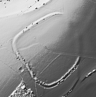
pastscape.org.uk/hob.aspx?hob_id=34733
A large circular earthwork is visible on Parracombe Common consisting of a bank and internal ditch which has been interpreted as a henge or a disc barrow. The earthwork forms an enclosure measuring 40 metres in diameter with a bank 3.4 metres wide by 0.4 metres high. It has an internal ditch 0.3 metres deep, and has been bisected by a hedge bank. There was no visible evidence of an entrance during field investigation in 1993. The monument is clearly visible on aerial photographs taken in 1952, but by 1972 it has been severely damaged by ploughing and other agricultural activity. Too much of the monument has been either obscured or destroyed to allow the various claims as to the monument’s nature to be evaluated purely on the basis of the surviving field evidence. On the aerial photographs from 1952, however, it most closely resembles a disc or saucer barrow.

Open Source Environment agency LIDAR

Open Source Environment agency LIDAR

Open Source Environment agency LIDAR

Open Source Environment agency LIDAR
An Inventory of the Historical Monuments in Dorset, Volume One
by the Royal Commission on Historical Monuments in 1952:
Earthwork on Shipton Hill (565 ft. above O.D.), ¾ m. N.E. of the church, forms an enclosure of about ¾ acre. The hill-top has been artificially steepened on the N. and S. sides and the two ends form natural ramped causeways leading up to the summit. At the base of the hill on both the N. and S. sides is a ditch with outer rampart of no great strength, and at the present time, for part of their length, both have almost disappeared. Both the ditch and rampart stop short of the E. and W. ends of the hill.
Between the base of the mound and the outer ditch at the eastern half of the S. side is a berm, but it seems probable that it is merely a natural outcrop of rock. The two pathways leading up the slope on the N. and S. are probably modern. On the top of the enclosure near the middle is a cross hedge-bank which appears to have been formed along the eastern scarp of a ditch to an earlier bank, traces of which can be seen immediately E. of the existing hedge-bank. Near the middle of the enclosure is a circular mound, of about 28 ft. diameter and 14in. high.
Beyond the rampart on the N. side, and to a much lesser degree on the S. also, are a series of rough terraces. They would seem to be a natural formation though their surfaces in one or two places show signs of disturbance. Warne (see above) mentions the disturbed nature of the N. E. part of the field immediately to the N.E of this camp and suggests the possibility of its being a Celtic village. This disturbance is still visible but is quite indeterminate.
From this very nice website about the hill: shiptongorge.org.uk/index.php/about-shipton/85-shipton-hill-and-hammiton-hill

Open Source Environment agency LIDAR

Open Source Environment agency LIDAR

Open Source Environment agency LIDAR

Open Source Environment agency LIDAR

Open Source Environment agency LIDAR

Open Source Environment agency LIDAR

Open Source Environment agency LIDAR


