
Looking SW. The huge ruined chambered cairn on top of Chapel Carn Brea hill can be seen on the far right.
Image credit: A. Brookes (18.6.2013)
Looking SW. The huge ruined chambered cairn on top of Chapel Carn Brea hill can be seen on the far right.

Looking south across the ruined mound. St Buryan church can be seen faintly on the skyline.

Showing W.C. Borlase’s excavation crater in the centre of the barrow. Looking ESE as the mist started to lift.

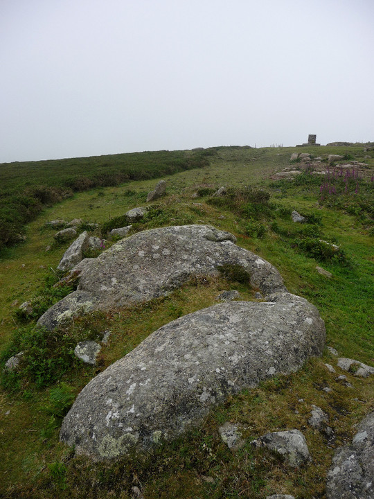
This huge slab, weighing several tons, forms the west side of the barrow. I couldn’t tell whether this is field clearance built into the adjacent wall or part of the original composition.

A fieldwall of enormous blocks has been built up alongside the barrow.
The barrow was excavated by William Copeland Borlase (great-great grandson of William Borlase):
Six miles west of Penzance on the brow of a hill on the right-hand side of the road leading to the Land’s End, was an undisturbed cairn 38’ in diameter, mounted on a pile of natural rocks, and surrounded by a ring of 16 large granite blocks set on edge.
On 21st Aug. 1868 the author proceeded with some miners to the spot, and caused an oblong trench to be sunk across the centre of the mound. About 18 inches from the surface was a pile of rocks, (the natural formation of the crest of the hill,) as will be seen on the accompanying plan.
Under a large flat stone a kistvaen was revealed. 1’4” in breadth and 18” deep constructed of eight stones in two layers of four each. These side stones were purposely fitted closely round an urn, mouth downwards which was filled with bones and two chipped flints, two more of which were found outside the urn but within the kist.
The vessel, which had no bottom, was brownish and not well baked and was ornamented with the usual chevron pattern, placed horizontally. It had four pierced bosses or handles. The bones, probably of a woman were not so completely calcined as is usually the case.
The sloping rock in the centre of the barrow was surrounded on all sides with ashes and charred wood; and beneath it, when raised, was nearly a cartload of ashes, as white and fresh as if a fire had scarcely been extinguished from them.
W.C. Borlase – Naenia Cornubiae (1872)
The plan can be seen here.

Looking SW across the long cairn.
Some massive stones are incorporated into the long mound.

The long cairn from the northeast.

The round cairn 30m to the south of the main chambered cairn. On a clear day, you can see the Isles of Scilly from here...

Mutilated round cairn 30m to the south of the chambered cairn.

Bent out of shape – seen from the south, the full extent of the damage done to the once-round cairn is apparent.

Huge slab on top of the chambered cairn.

This is a big cairn, for all the damage done.

Ruined structural material on the top of the chambered cairn, on a day of no visibility.


Long slab and naturally worn basin in the cairn.

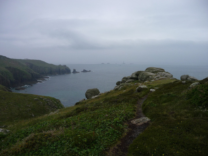
Looking SW towards Land’s End and a near invisible Longships lighthouse.

The very fine Mayon Cliff cairn, on a less than very fine morning.

The curving double rampart, seen from the north. The silhouetted walker provides scale.

Upright, presumably placed, boulders inside the fort.

Looking back up the fort’s interior, from the seaward end. Note row of apparently placed boulders, far right.

Further impregnable approaches. Looking towards Land’s End and Longships.

Sea and sheer cliffs provide the defence needed from the west.
The interior of the fort contains a number of rocky outcrops.

Still-impressive stonework flanks the entrance to the fort.

Looking SE across the cairn, down the Rhondda Fawr.

The little cairn is much clearer than on my previous visit, especially as the bracken growing from the robbed centre has gone. Looking north across Rhondda Fawr to Mynydd Tynewydd.

Maindy Camp is the flattened area in the centre, just above the cloud-shadow. Viewpoint is Tarren Felen Uchaf, near the Cwm Ian cairn.

Looking north across the Rhondda Fawr to Mynydd Tynewydd. Pen y Fan and the central Brecon Beacons can be seen from here, beyond the wind turbines, but were very faint in the haze on this visit. An answer to Carl’s question about whether they have nice days here, anyway.

Although the barrow itself may not be the most impressive, its upland positioning is pretty good. Seen from the cliffs of Craig Ogwr to the east.

Landscape context for the Mynydd Ton and Mynydd William Meyrick cairns (Garn Fawr and Garn Fach). Seen from the eastern slopes of Werfa, across the head of the Ogmore Valley.

Landscape context for the position of the cairn overlooking Cwm Ogwr Fawr/Ogmore Valley. Seen from Bwlch yr Afan to the north.

Crug yr Afan seen prominently on its hilltop from the slopes of Werfa, to the SW.

Despite some poor treatment, this remains an excellent monument. The “upper” and “lower” cairns can be easily distinguished from the south.

Possible kerbing on the south side of the cairn.

Looking due south across the shattered “upper” cairn. The hill directly ahead is home to Carn yr Hyrddod, while the Ogmore Valley falls away to the left of centre.

Looking SSE. The hill on the far left is Mynydd Ton, boasting yet more Bronze Age cairns.

Small upright at the base of the “upper” cairn, possibly part of a kerb.

Looking over the wrecked top of the cairn, showing the concrete block reported by Carl, which I think might be the remains of a trig pillar, fallen into the central scoop. The big hill on the far skyline is the near-2,000ft Craig y Llyn, topped with several of its own cairns.

Arriving at the cairn from the north, thankful that the mud surrounding the monument has been baked hard.

Anyone looking to find the ring cairn could look out for this sizeable natural boulder next to the track to the south (the boulder is visible from the track whereas the ring cairn, being elevated above the track, is not). The ring cairn can be seen occupying the flat ground behind.

Archive picture showing the view across the field towards the fort, taken from the road to the north. The foreground is occupied by the “lost” long barrows that have given rise to the amazing finds in 2013.
Two cairns on the rocky ridge of Cribarth. Coflein descriptions:
Northern cairn (SN82901443)
A cairn of limestone boulders is located at the north-east end of a ridge. It measures about 19.8m in diameter though its precise size is hard to determine because it merges with scree on the west and south west. Its height is about 1.8m on the north and east, and 3m on the south-west. A length of massive kerbing is visible on the south side of the cairn. It is composed of limestone blocks set drystone fashion (rather than earthfast) and is visible for 5.5m.
The mound has been generally disturbed.
Southern cairn (SN82831420)
A cairn of limestone boulders is located at the SW end of a ridge. It measures roughly 13.7m in diameter though its precise dimensions are hard to determine because much of the cairn mass has collapsed down the sides of the ridge, especially on the W. Much of the centre of the mound has been modified into a shelter. The overall height of the cairn is now c.2m on the NE, 1.2m elsewhere.
A trig pillar lies to the immediate S.
Aerial photo here.
Aerial photos showing the landscape setting of the hills above the cave system.


