
One of the fallen stones is “faced” with an exposed vein of quartz, giving the stone the look of a piece of iced cake.
Image credit: A. Brookes/AMJ (4.10.2012)
One of the fallen stones is “faced” with an exposed vein of quartz, giving the stone the look of a piece of iced cake.

Various stones at the site.

Detail of quartz pebbling on one of the fallen circle stones.

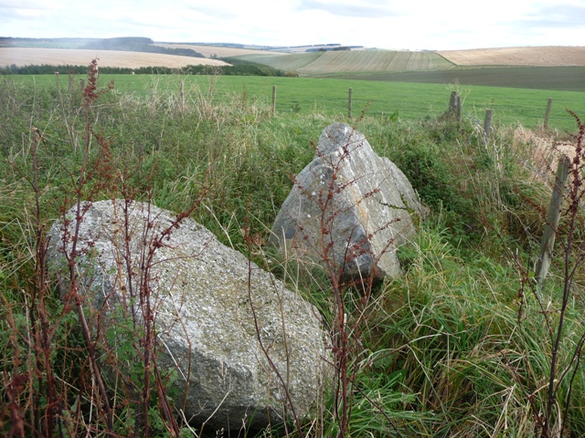
Fallen west flanker and upright recumbent.


The track to Corrydown, shown on the Ordnance Survey map heading south from Uppermill Farm, passes through this gate and over the grassy area behind. Once the stream has been crossed (approx 100 metres ahead of this point), the metalled path reveals itself.

The Recumbent stone and fallen pillars at Corrydown Stone Circle.


Visited: February 24, 2012
I had tried to visit this Stone Circle remnant last year but ended up completely baffled by the ‘missing path’ reported by other observers. But, as I found out later, the path is still there.
Anyway, turning left from the B992 at the Cushnie sign, just before Auchterless (heading north), I visited the Mains of Hatton Circle before turning right at the following crossroads, past Pitglassie, to park at the end of the metalled road leading to Uppermill Farm. I walked to Uppermill, crossed the field to the right, and then the stream. This is a ‘trenched’ stream, and the far bank is in many places a daunting vertical obstacle. However, after searching a while, I found a place where it proved possible to step over the stream.
Now I started to contour, anticlockwise, around the hill—and within a few paces, there was the ‘missing’ path. Everything was easy now: just follow this path round the hill to the ruined Corrydown farmhouse, and the field gate appeared immediately adjacent.
All that remained was to follow the field margin for about 200 metres, and there were the recumbent and fallen pillars of Corrydown Stone Circle. Eveything is enclosed by a fence, and a number of the other circle stones, partly buried, can still be seen.
This is the best time to see remnant circles such as Corrydown. From early summer onwards their fallen stones become buried in a tangle of weeds and grasses and can be hard to view. In late winter, the previous years growth has collapsed and they are seen much more to advantage.
Finally, for the return to Uppermill, I steadfastly followed the path till I arrived at a rusted gate, with the Uppermill Burn ahead. Close inspection
revealed that the path actually continued across the burn, which was culverted for several metres. This covered section was somewhat disguised by a growth of saplings on top of it, but this was no obstacle to progress. There now followed a walk over a grassy stretch behind the farm buildings on the south side of the approach road, two gates to cross, and I was back at the start of my walk.
The mystery of the disappearing path is this: the path shown heading south from Upperhill (on the OS map) is now closed off by a gate (see photo), and what used to be the first 100 metres of the path has been grassed over (perhaps deliberately, to discourage walkers?). Just pass through the gate and follow the field edge on your left, along the grass behind the buildings, till you reach the stream. The clump of saplings indicates where you can cross. Step over the old rusted gate ahead, and you are on the path, which takes you almost all the way to the circle
This is quite a difficult place to get to. Leaving Turriff by the B9024 take the Balloch Brae road, first left. You can see the circle and Corrydown. A road, at Uppermill Farm 3rd tarred road on the right (4 miles from Turriff), on some maps has gone and the Glasslaw burn has to be crossed. Far better to go further along the towards Thornliebank, past Pitglassie, turning left to Auchterless at its crossroads with Fortrie (past the Greymuir Cairn). On the way visit Mains of Hatton RSC go past the farm of the same name then turn left/north until the Backhill Of Thomastown. From here I walked the 11/2 miles to the Corrydown farm. The circle is in the field to the right being easily spotted as it is surrounded by a fence.
The recumbent is still in situ with a fallen flanker. Other stones have been moved as the folklore tells. At the northern end there appears to be a small kerb cairn.
I mentioned three sites but at least another five are in the near surrounds. To me, this would make an excellent day. Good boots – varied terrain!
Visited October 08.
The notion that ill-luck attends the destruction of the circles is not yet altogether dead, as is apparent from an incident which occurred in recent times at Corrydoun. Some alterations were being made on the farm buildings, and the mason employed to do the work reckoned that he could make good use in his building operations of the stones in the stone circle. So he set to work to trim one of them, but, finding the stone harder than he had supposed, made little progress. At the dinner-hour he returned to the farm, where it was noticed that he had damaged one of his fingers badly, an injury of which he was not conscious. Someone suggested that it was unlucky to interfere with the stones, and the workman, agreeing, made no further attempt to use them; but his tool-marks still remain.
From: Ritchie, J., Folklore of Aberdeenshire Stone Circles, in Proc. Soc. Ant. of Scotland, LX, 1926, pp304-313.
Only the recumbent remains (barely) upright, but most of the circle stones can be seen on the ground.


