The stone rows with Moor Divock Central in view.
The stone rows with Moor Divock Central in view.

A short stretch of the parallel stone rows at Moor Divock.
It was an absolutely fantastic day on Moor Divock when we went. Having made a brief visit to The Cockpit, we returned, impressed by the circle but mightily irritated by a man sitting on one of the stones making very loud business calls (why out there?) while his family got increasingly bored. It’s a weird phenomenon – after not being able to get mobile reception anywhere you find it at the stone circle. This happened at Callanish – 7 text messages arrived all at once!
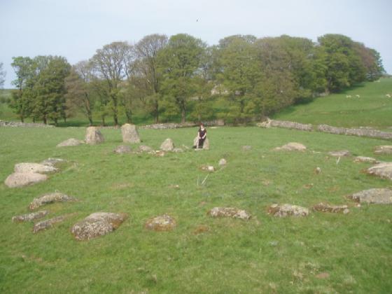
On the way there we’d spotted the obvious megaliths like The Cop Stone and White Raise, but on the way back many more cairns revealed themselves to us. Making a short detour to Moor Divock Centre, we stumbled across two parallel lines of stones. I’d read briefly about the alignment, but hadn’t thought we’d be able to find it. However, once you’re there, it’s blindingly obvious you’re at a stone row – that’s if you go on a very bright sunny day when there’s virtually no bracken in late May to early June. They are indeed very low, but in a parallel alignment.
This is quite visible from the path from The Cop stone to The Cockpit, a couple are silhouetted on the ridge to the NE of the path. But I’d hate to try and find it in bracken season.
It’s the kind of thing that, without prior awareness, and if it were elsewhere, you’d probably look at and dismiss any thoughts of prehistoric significance as the product of your imagination, or at best, the remains of a field boundary. The stones are low and the gaps are wide, not like the Dartmoor jobbies.
But in this landscape, it’s much easier to imagine it as a remnant of a much wider plan, relating somehow to the other bits and bobs in the area.
Extract from E.H’s Scheduled Monuments Record:
The monument is a stone alignment on Askham Fell situated on a line between White Raise round cairn and Askham Fell ring cairn. It is divided into two separate areas by a natural sink hole. The easterly part includes two virtually parallel alignments of irregularly spaced stones 6m-9m apart, orientated approximately north west – south east, and running for a length of 70m.
There are fifteen stones in the northern line and seven stones in the southern line. Some of the stones remain upright while others appear to have fallen. The maximum height of the stones is 0.3m. At the south east end there is a slight bank up to 0.1m high and 1m wide that continues the southernmost alignment of the stones for a further 8m. The western part of the monument
continues approximately on the same alignment as the northern line of stones for a further 44m and includes seven irregularly spaced stones up to 0.45m high.