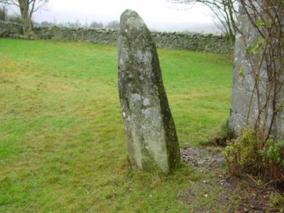
20/12/03- with Black Meldon on the left and White Meldon on the right
Images
20/12/03- the cupmarked boulder which sits in between the two stones
20/12/03- the southernmost stone
20/12/03- the northernmost stone
20/12/03- to the South
20/12/03- to the West
20/12/03- looking North
20/12/03- looking ENE
Articles
Saturday 20/12/03
These two stones stand in a field at the southern ends of the hills of White and Black Meldon which are both topped with forts, and all around are settlements, hut circles and cairns. The stones are aligned N/S and are 2.1 metres apart. The northenmost stone is approximately 1.1 metres high and is very angular with almost small steps up its southern side. The southern stone contrasts this by being very rounded and smooth, leaning back to the south. This stone is slightly large- about 1.3 metres high. Between the stones are some large boulders- one of which has a cracking cupmark on it- but is possibly natural. There are stories of other smaller stones being associated with these. I am busy with my notes when I suddenly feel like I’m being watched- I look up and meet the stares of around 200 faces- a line of sheep all watching with intent as to what I’m up to in their field!
The Old Statistical Account from 1791-1799 notes that there were other stones, approximately 1 foot high running east from these at regular distances on a curved line. On 18th July 1921 some ‘careful digging by three men’ brought nothing to light.
An entry from Ancient Stones, an online database that covers most of the standing stones, stone circles and other stones found in South East Scotland. Each entry includes details, directions, photograph, folklore, parking and field notes on each location.
Sites within 20km of Sheriff Muir
-
Black Meldon Fort
photo 13 description 3 -
Kirkton Manor
photo 8 forum 1 description 2 link 2 -
Meldon Burn
photo 8 description 1 -
White Meldon Fort and Cairn
photo 15 description 1 link 1 -
Cademuir Hill
photo 24 description 4 -
The White Stone
photo 2 description 3 link 1 -
Janet’s Brae Settlement
photo 1 description 3 -
Janet’s Brae Fort
photo 4 description 2 -
Whiteside Hill
photo 9 description 1 -
Drumelzier Haugh
photo 4 description 3 -
Kittlegairy Burn Settlement
photo 2 description 2 -
Pyked Stane Hill
photo 5 description 1 link 1 -
Cardie Hill Fort
photo 1 description 2 -
Tinnis Castle
photo 14 link 1 -
Wether Law
photo 4 description 1 link 1 -
Henry’s Brae
photo 10 link 1 -
Dreva Craig
photo 16 description 2 -
Old Harestanes
photo 13 forum 1 description 3 link 1 -
Cardrona Mains
photo 8 description 3 link 2 -
Birks Cairn
photo 6 description 2 -
Langlaw Hill
photo 4 description 1 -
The Mount
photo 2 description 1 -
Castle Knowe
photo 7 -
Drumelzier
photo 6 link 1 -
Dundreich
photo 3 description 1 -
Lamancha
photo 4 description 1 -
Jeffries Corse
photo 4 description 1 -
Caerlee Hill Fort
photo 3 description 2 -
St. Ronan’s Well
photo 4 description 3 link 1 -
Cleuch Hill
photo 4 description 1 link 1 -
West Linton Cist Cemetery
photo 2 description 2 link 1 -
Innerleithen Parish Church
photo 8 description 2 link 2 -
Torykneis
photo 3 description 1 -
Pirn Hill Fort
photo 9 description 1 link 3 -
Old Deepsykehead Enclosed Cremation Cemeteries
photo 5 description 1 -
North Muir
photo 22 description 3 -
Harlaw Muir
photo 3 description 1 -
Mitchelhill Rings
photo 17 description 2 -
Bizzyberry Hill
photo 26 description 3 -
White Hill
photo 7 description 1 -
Hearthstane
-
Nisbet, NE of Cow Castle
photo 5 description 1 -
Cheese Well
photo 8 description 6 link 2 -
Langloch Knowe
photo 4 description 1 -
Cow Castle
photo 12 description 2 -
Minch Moor
photo 1 description 1 -
The Gowk Stane
photo 9 description 2 link 2 -
Weston
photo 25 description 2 -
Giant’s Stone
photo 15 forum 1 description 5 link 1 -
Menzion Standing Stones
photo 4 description 2 link 1 -
The Yarrow Stone
photo 8 description 2 link 3 -
Burngrange
photo 7 description 2 -
Camp Hill
photo 3 description 1 link 1 -
Glebe Stone
photo 14 description 3 link 4 -
Warrior’s Rest
photo 8 description 3 link 4