Open Source Environment agency LIDAR
Image credit: © Environment Agency copyright and/or database right 2015.
Open Source Environment agency LIDAR
Just a word of warning to anyone thinking of visiting this site. The landowner is not at all happy for people to set foot on his land. He has “asked” me not to use the footpath that runs through his farm and has gone to court to try and get it taken off the map. I have also been told by others in the know that he has threatened others, so...
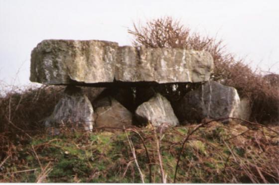
Mentioned by Craig Weatherhill, in “Cornovia: Ancient Sites of Cornwall & Scilly” (Cornwall Books – 1985, revised 1997 & 2000) – “This Iron Age fort, 89m in diameter, is essentially univallate, but an outer defence occurs on the south-west side. The fort perches on the brink of a steep slope above a valley to the west. The defences are fairly well preserved, especially the main rampart which is from 1.6m to 2.3m high. The lowest stretch is on the north side where there are no longer any remains of the outer ditch. The interior of the fort was artificially cut into two distinct terreaces. The entrance faces south-west.”