The recumbent from within the circle. 4.1m x 2.3m.

The recumbent from the outside. Note the cupmarks.

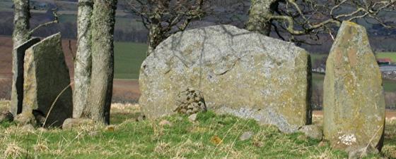
Looking W. The surviving circle stone and the recumbent.
Agree entirely with Merrick’s assessment that this is a sight you should not miss.
On paper, it sounds tame. A recumbent and one circle stone were not enough stones to include it in the list of target sites for my March trip... but this punches well above its weight.
The view has been well covered in Merrick’s post. The massive recumbent (second only to the lofty Tyrebagger in height) dominates the site. It’s amazing it’s still standing because, like most recumbents, it simply sits on the ground surface. Cattle rubbing and trampling have failed to shift its estimated 12 tons. There are suggestions of cupmarks on its outer surface.
Ask at Loanend farm. They suggested driving up to near the site where there is a verge to park on.
Visited 20 October 2005
(notes on top of the hill, 2 July 00)
Having read of Julian Cope’s bullock barricade blocking his visit to Hawk Hill, we were dismayed to see a field full of horned male and female cattle as we came up the track, but the friendly man at Loanend said they were young and harmless. However, thirty cows running makes a frighteningly thunderous noise and we were nervous enough to bunk into the adjacent field for as much of the climb as possible.
Eventually we reached the summit and climbed the wire fence by the monstrous freestanding recumbent and the cows stayed back. And there we saw for the first clear time *that* view. The last five metres brings Dunnideer into view to the north alongside its two sister hills, and then to the west, after three days of it hiding in mist and cloud, we saw the distant Silbury shape of Tap O’Noth!
This hill that looked so weedy and low from the road at its foot feels so very high and central up here, deceiving me into feeling above the Dunnideer triplets! The recumbent is absolutely HUGE and appearing to be contoured to align with the south-western horizon. The breeze comes through the hilltop pine trees making a sound like the sea and the sun is shouting down at us to love this place.
Don’t let the OS map’s ‘Stone Circle (rems of)’ or the Modern Antiquarian’s ‘destroyed stone circle’ denotation put you off coming here, this is such a site, as big a buzzy mindblower as we’ve seen anywhere on this whole Aberdeenshire trip!
This could be the place:
Often sickness among a herd followed the removal of a stone. Near Auchleven in Premnay, once stood a stone circle now destroyed. The farmer, who moved the stones, soon after lost many of his cattle and was ruined.
From ‘Primitive Beliefs in the Northeast of Scotland’ by J M McPherson (1929).