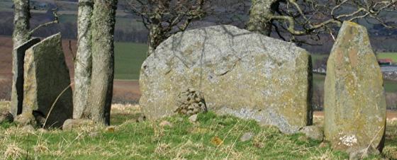
Langstane O’ Craigearn viewed from N. Access is restricted. (19.09.19)
Images
You can get some idea of the scale of this from the fence.
A whopper.... More or less in someone’s garden. Didn’t have time to ask to see it closer. Maybe one day!
Articles
I visited the Langstane o’ Craigearn on 19.09.19, approaching from N. Access to the stone is restricted. It appears to be enclosed in a private garden.
This is an easily found standing stone and what a beaut it is as is its near neighbour at Woodend. This is much more accessible. Leave the B993 after Kemnay and turn south towards Craigearn pulling in at the second drive on the east side. Walk a short distance to a gate, the Lang Stane stands impressively in the middle of the field. If there weren’t trees magnificent views of Bennachie would be seen.
No witches to be seen today. If there was a stone circle here, if all the stones had similar stature, what a place this must have been.
Visited 24/07/2010.
It is said that witches used to convene their covens around this huge 3.5m stone.
(Grinsell – Folklore of Prehistoric Sites of Britain)
A source from the turn of last century said it is supposed to be the last remaining stone of a stone circle (noted on the Canmore database). But especially considering its enormous height, this seems particularly unlikely? and I doubt it is still an entertained theory. Was it the wishful thinking of an antiquarian? Or was it a genuine folk story about the stone? Either way it seems to point to somebody’s feeling about the site’s importance in the past?
Has info on quite a few Aberdeenshire sites including some of the more obscure ones – inc the Langstane!
Topics
Sites within 20km of Langstane o’ Craigearn
-
Nether Coullie
photo 5 description 2 link 1 -
Deil’s Stane
photo 6 description 2 -
Woodend of Cluny
photo 6 description 2 -
John Bells Stone
photo 1 description 1 link 1 -
Balgorkar
photo 35 description 5 -
Braeneil
photo 2 description 1 -
Lumphanan Hill
photo 4 description 1 -
Nether Lauchentilly
photo 3 description 2 -
Deer Park
photo 22 description 3 -
The Knock
photo 3 description 1 -
Chapel O’Sink
photo 5 description 3 -
Tombeg
photo 6 description 2 -
The Ark Stone
photo 3 description 1 -
Leylodge School
photo 3 description 1 -
South Leylodge
photo 18 description 2 -
Leylodge School 2
photo 3 description 1 -
South Leylodge
photo 3 description 1 -
Old Kinnernie
photo 5 description 1 -
Clovenstone Farm
photo 3 description 2 -
Camies Stone
photo 2 description 3 link 1 -
Nether Corskie
photo 7 description 2 link 2 -
Easter Aquhorthies
photo 114 forum 1 description 19 link 2 -
Broadsea Farm
photo 4 description 1 link 1 -
Bruce’s Camp
photo 4 description 2 link 1 -
Millstone Hill East 2
photo 6 description 1 link 1 -
Millstone Hill East
photo 7 description 2 link 1 -
Wolf Stone
photo 8 description 2 -
Little Fornet
photo 6 description 1 -
Wester Echt
photo 11 description 3 link 1 -
Cairnhall
photo 12 description 1 link 2 -
Broomend Cist(s)
photo 6 description 1 -
South Fornet
photo 8 description 1 link 1 -
Broomend 2
photo 4 description 1 -
Orde’s Cairn
photo 3 description 1 -
Upper Broomhill
photo 3 description 1 -
Midmill
photo 8 description 1 link 2 -
Broomend
photo 5 description 1 -
Broomend of Crichie
photo 56 forum 1 description 10 link 3 -
Hill of Tuack
photo 12 description 1 link 1 -
Gouk Stane, Bennachie
photo 2 description 1 link 2 -
Middleton
photo 1 description 1 link 1 -
Corsindae
photo 5 description 1 -
Corsindae
photo 3 description 1 -
Corsindae
photo 3 description 1 -
Hill Of Boghead
photo 6 description 1 -
Hill Of Whitecross
photo 7 description 2 -
Heather Hill
photo 6 description 1 -
Barmekin Hill
photo 29 description 5 link 1 -
Ferneybrae
photo 4 description 1 -
Cuning Hill
photo 7 description 1 -
Dilly Hill Cairn
photo 3 description 1 -
Dilly Hill 3
photo 3 description 1 -
Whitehills
photo 44 description 5 link 1 -
East Blairbowie
photo 6 description 2 -
Dilly Hill 2
photo 3 description 1 -
Kintore Golf Club
photo 6 description 1 link 1 -
Dilly Hill
photo 3 description 1 -
Waterside
photo 7 description 1 link 1 -
Brandsbutt
photo 15 description 2 link 3 -
Luath’s Stone
photo 18 description 5 -
Mither Tap
photo 64 description 7 link 2 -
Conglas
photo 4 description 1 -
Drimmies
photo 4 description 1 -
Midmar Kirk
photo 65 forum 1 description 12 link 3 -
Conglas 2
photo 5 description 1 -
The Drum Stone
photo 1 description 3 -
Sunhoney
photo 69 forum 1 description 8 link 2 -
Greenlands
photo 4 description 1 link 1 -
Balquhain
photo 28 forum 1 description 4 link 2 -
Cairntradlin
photo 4 description 1 -
Hillhead Of Suttie
photo 5 description 2 -
Oxen Craig South Western Descent
photo 15 description 1 -
Oxen Craig Peak 2
photo 1 description 1 -
Socket Stone Rock
photo 3 description 1 -
Oxen Craig
photo 29 description 3 -
Bennachie
photo 33 description 9 link 1 -
Maiden Castle (Pittrodie)
photo 17 description 2 link 1 -
Kinellar Kirkyard
photo 12 description 2 -
Larrick
photo 5 description 1 -
Little Oxen Craig
photo 5 description 1 -
Pittodrie Quarry
photo 4 description 1 -
Balhalgardy
photo 2 description 2 link 1 -
Newton Wood
link 1 -
Tomnagorn
photo 25 forum 1 description 3 link 1 -
Liggars’ Stane
photo 4 description 2 link 1 -
Auchronie
photo 3 description 1 -
Peat Hill
photo 3 description 1 -
Hill Of Knockollochie
photo 4 description 1 -
Peat Hill
photo 4 description 3 link 1 -
Newlands Of Oyne
description 1 link 1 -
Tertowie
photo 4 description 1 -
Hill Of Selbie
photo 6 description 1 link 1 -
Little Hillbrae
photo 4 description 1 link 1 -
Gouk Stone, Kinaldie
photo 6 forum 1 description 1 link 1 -
Little Clinterty
photo 3 description 1 -
Auld Kirk O’ Tough
photo 8 description 3 -
Leggetsden
photo 3 description 1 -
Mill of Fintray Cursus/
Multiple Stone Rows / Avan link 1 -
Finnercy
photo 7 description 1 -
Hill of Keir
photo 17 description 2 -
Garlogie Woods
photo 3 description 1 -
The Gouch Stone (destroyed?)
description 1 -
Garlogie
photo 5 description 1 -
Red Hill
photo 3 description 1 -
Mill of Carden
photo 9 description 1 link 1 -
Springhill
photo 12 description 2 -
Cothiemuir Wood
photo 61 description 14 link 3 -
Cloch More
photo 6 description 1 -
Berryhill
photo 8 description 1 -
Gowk Stane, Oyne
photo 7 forum 1 description 1 -
Kirkton Of Oyne
photo 8 description 1 -
Donald’s Hillock
photo 5 description 1 -
Berryhill
photo 5 description 1 -
The Slacks
photo 13 description 1 -
The Slacks
photo 3 description 1 -
Souterhill
photo 11 description 2 -
Hawk Law
photo 4 description 1 -
Tillymuick
photo 6 description 1 link 1 -
Auchencleith
photo 5 description 1 -
East Hill Croft
photo 7 description 1 -
Hillhead Of Barra
photo 6 description 1 -
South Auchinclech
photo 4 description 1 -
Stoneyhill
photo 3 description 1 -
Mote Hill
photo 6 description 1 -
Cullerie
photo 30 forum 2 description 10 link 1 -
Bishop’s Lands
photo 7 description 1 -
Blue Hill
photo 5 description 1 link 1 -
Pitscurry
photo 7 description 1 -
Woods Of Cairnie 2
photo 5 description 1 -
Woodland’s Wood
photo 6 description 1 -
Cobrigdale Hill
photo 4 description 1 -
Kirkton of Bourtie
photo 48 description 5 link 3 -
Lumphart Hill
photo 6 description 1 -
Woods Of Cairnie 1
photo 5 description 1 -
Woods Of Cairnie 4
photo 5 -
Woods Of Cairnie 3
photo 5 description 1 -
Westerton Of Petmathen
photo 8 description 2 link 1 -
Piper’s Stone
photo 4 description 1 link 1 -
Findlatree
photo 4 description 1 -
Bellman’s Stone
photo 3 description 2 -
Druidstones
photo 15 forum 1 description 5 -
Baldyvin
photo 3 description 1 -
West Benthoul
photo 6 description 1 -
The Law
photo 11 description 3 -
Easterhill
photo 7 description 1 -
Old Keig
photo 43 description 3 link 2 -
Wallace Stone
photo 1 description 2 -
Hill of Barra
photo 25 description 4 link 1 -
Hill Of Airlie
photo 6 description 1 -
The Barmkyn
photo 16 description 2 link 1 -
Benthoul
photo 3 description 1 -
Hatton of Ardoyne
photo 14 description 3 -
Durno
photo 3 description 1 -
Tulloch Boundary Marker 33
photo 5 description 2 link 1 -
Tyrebagger
photo 83 forum 3 description 15 -
Old Rayne
photo 28 description 5 link 2 -
Craigenet
photo 8 description 3 -
North Strone
photo 14 description 3 -
Crookmore
description 1 link 1 -
Mimrikin’s Clump
photo 5 description 1 -
Burryhillock
photo 4 description 1 -
Harvey’s Cairn
photo 3 description 1 -
Loanhead of Daviot
photo 90 forum 1 description 12 link 2 -
Shieldon
photo 52 description 6 link 1 -
Bruce’s Seat
photo 2 description 2 -
Backley Hill
photo 4 description 1 -
Backley Hill 1
photo 6 description 2 -
Backley Hill 2
photo 6 description 1 -
Brownhills 2 (near Ardoyne)
photo 2 description 1 -
Brownhills (near Ardoyne)
photo 4 description 1 -
Brimmond Hill
photo 10 description 1 -
Pitmachie
photo 3 description 1 -
Druidsfield
photo 16 description 1 -
New Craig
photo 9 forum 1 description 1 link 2 -
Westerord Plantation
photo 5 description 1 -
Clashholm
photo 8 description 1 link 1 -
Satter Hill
photo 6 description 2 -
Highland Wood Croft
photo 8 description 1 -
Craigievar
photo 7 description 3 link 1 -
Cairnhill
photo 2 -
The Good Man’s Fauld
photo 1 description 1 -
New Craig
photo 15 description 5 -
West Hatton
photo 4 description 1 link 1 -
Hawk Hill
photo 6 description 3 -
Braedale
photo 10 description 1 -
Monykebbuck
photo 6 description 1 link 1 -
Learney
photo 7 description 1 -
Sundayswells Hill
photo 9 description 1 link 1 -
Balcairn
photo 2 description 1 -
Chapel of Elrick
photo 5 description 1 -
Bowman Stone
photo 3 description 1 -
Bowman Stone 2
photo 3 description 1 -
Tillyching 2/
3 photo 9 description 1 -
South Lediken
photo 3 description 1 -
Tillyching 1
photo 7 description 1 -
Hillhead Of Tillyching
photo 6 description 1 -
Auld Kirk Of Alford
photo 9 description 1 link 1 -
Carnaveron
photo 3 description 1 -
Newton Stone
photo 10 description 2 -
Drum Castle
photo 4 description 1 -
East Brotherfield, Boundary Marker 25
photo 6 description 1 -
Gallow Cairn, Torphins
photo 8 description 1 -
Gallow Hill
photo 8 description 1 -
Wantonwells
photo 23 description 3 -
Knock Saul
photo 5 description 2 -
Scotsmill
photo 2 description 3 link 1 -
Balnacraig
photo 6 description 1 link 1 -
Drumfours
photo 3 description 2 link 2 -
Goval
photo 7 description 1 -
Beans Hill
photo 4 description 1 -
Bardshillock Wood
photo 3 description 1 -
Beans Hill, Boundary Marker 23
photo 4 description 1 -
Braehead
photo 10 description 2 link 2 -
Glassel
photo 32 forum 1 description 8 link 1 -
The Grinago Stone
photo 7 description 2 link 1 -
Newells
photo 5 description 1 -
Blacktop
photo 7 description 1 link 2 -
North Rayne
photo 3 description 1 -
Loch Of Leys
photo 3 description 1 -
Dunnideer
photo 26 description 5 -
Dunnydeer
photo 5 description 1 -
Macbeth’s Cairn
photo 7 description 2 -
Hill Of New Leslie
photo 3 description 1 link 1 -
Hill Of Christ’s Kirk
photo 10 description 3 link 1 -
Blacktop Wood
photo 4 description 1 -
Inschfield
photo 9 description 3 -
The Ringing Stone
photo 3 description 2 link 1 -
Mellenside
photo 7 description 1 -
East Brathens
photo 4 description 1 -
Dunnydeer Farm
photo 17 description 3 link 1 -
East Brathens
photo 4 description 1 -
Westfield
photo 5 description 1 -
Bogton (Drumoak)
photo 2 forum 1 description 1 -
Denwood
photo 7 description 1 -
Stot Hill
photo 3 description 1 -
Cairn Mude
photo 10 description 2 -
Damil
photo 4 description 1 -
Corrie
photo 5 description 4 link 1 -
Binghill East
photo 5 description 1 -
Binghill West
photo 7 description 2 -
Binghill
photo 18 forum 1 description 3 link 1 -
Hilton Farm, Boundary Marker 18
photo 5 description 1 -
Crathes Castle
description 2 -
Stranduff
photo 6 description 1 -
Stonehead
photo 25 description 8 link 1 -
Corsee Wood
photo 4 description 1 -
Crathes Castle Policies
photo 7 description 1 -
Woodbine Cottage
photo 7 description 1 -
Banchory Hospital
photo 5 description 1 -
Nether Balfour
description 1 link 1 -
The Tow Stone
photo 2 description 3 -
Fallow Hill
photo 4 description 1 -
Clerkhill Wood
photo 5 description 1 -
Macbeth’s Stone
photo 2 description 1 -
Mowat Newton
photo 3 description 1 -
Mowat Newton 2/
3 photo 5 description 2 -
Dalmuinzie Farm, Boundary Marker 16
photo 4 description 1 -
Culsalmond
photo 1 description 2 link 1 -
Balbridie
photo 1 link 1 -
Hill Of Rothmaise
photo 5 description 1 link 1 -
Mummer’s Reive
photo 4 description 1 link 1 -
Moorlands
photo 4 description 1 -
Inchmarlo
photo 6 description 1 -
Banchory Manse
photo 3 description 2 -
Candle Hill
photo 28 description 7 -
Colpy
description 1 link 1 -
Kirk Wood (Leochel)
photo 6 description 1 -
Knappach East
photo 3 description 1 -
Hillhead Of Maryfield
photo 2 description 1 -
Den Wood
photo 8 description 2 -
Knappach West
photo 4 description 1 -
The Knappach
photo 5 description 1 -
Hill Of Trustach
photo 3 description 1 -
Trustach
photo 3 description 1 -
Sluie Hill
photo 5 description 1 -
Leochel-Cushnie
photo 4 description 1 -
Whitestripes
link 1 -
Upper Balfour
photo 3 description 1 -
Upper Balfour 2
photo 3 description 1 -
Upper Balfour 4
photo 5 description 1 -
Upper Balfour 3
photo 5 description 1 -
Kirkton Wood
photo 5 description 1 -
Udny Green, Home Farm
photo 5 description 1