Images
Visited June 2011
Visited June 2011
Visited June 2011
This panorama consists of a set of three photographs taken of Balquhan Stone Circle near Inverurie in Aberdeenshire.
An elevated view of Balquhan Stone Circle gained from a camera mounted on a monopod held above my head.
Taken May 2008 – the circle within a rape seed oasis.
the large white quartz outlier.
.o0O0o.
16-9-06
wolfy
16-9-06
wolfy
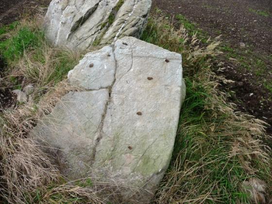
cup marks
16-9-06
wolfy
the cup marked stone..
16-9-06
wolfy
16-9-06
wolfy
16-9-06
wolfy
Fallen east flanker, recumbent (3.8m long) and west flanker (2.3m high).
Looking S
The recumbent, the west flanker, and two circle stones (the one to the left having cupmarks on its outer face).
3.1m high quartz outlier on SE of circle.
From the nearest road
6th April 2002
6th April 2002
6th April 2002
Balquain – 23.8.2002
Articles
March 12, 2013
With the unexpected return of winter I took my chance when the morning cloud broke into welcome sunshine. The plan was to visit some of the stone circles around Inverurie, starting with Balquhan.
All seemed well as sunshine followed me all the way to Balquhan Mains where I parked just off the crossroads. Bennachie looked grand with its cap of snow gleaming in the sun as I set off on the walk through the farm to the circle. But as I approached the monument, the skies started to darken, Bennachie disappeared into the gloom, and I realised I had just minutes to enjoy sunlit views of the circle.
I made it in time and was rewarded with some splendid wintry photographs of Balquhan Stone Circle. I used a monopod to gain height and the elevated view was quite revealing. Another set of photographs was combined into an excellent panorama.
Conditions showed no signs of improving as I returned to the car, and minutes after I moved off it started to snow. Inland it looked bleak indeed, and I reluctantly headed back home.
This is a great site but you really need a good day to fully appreciate it.
In the sun, the 3.1m white quartz outlier would look magnificent. In the dull flat light of the day of my visit, it was just another stone. Similarly the cupmarks needed a lot of faith to see and they just refused to be photographed.
Oh well, at least it wasn’t raining.
Visited 18 March 2005
Balquain Stone circle (23.8.2002)
I found this hard to find without an OS map or decent instructions. And also frustrating because I could see it in the field but wasn’t quite sure how to get to it and where the farm was to ask for permission. Personally I would say either get an OS map, or follow these instructions. If travelling North on the A96 look for the first junction after Inverurie. Take the road west from the junction (signposted from the A96 as Chapel of Garioch) and after exacty 1 kilometre go right at the first road junction / crossroad (it is a crossroads but in reality it doesn’t seem like one and is very small). You MAY just spot a farm sign saying ‘Balquain Main’ at this crossroads. On this track there is a farm about only about 70 metres on your left. The farmer said I could drive up the track for another 70 metres or so and park at the two holiday cottages that he lets out to holidaymakers. He may say something else to you; who knows. Then I walked a bit further up the track and across the edge of two fields to my right (East). It was about a 10 minute walk from the farm to the circle.
The circle was heavily overgrown when I visited, and the rest of the field was ploughed, making it really stand out whilst driving along the road towards the crossroads. The height and ferocity of the grass made it hard to get around (it was far higher than the photo in TMA), but it is in a great setting, and it’s interesting to wonder what it could have looked like many years ago.
An isolated patch of grass, nettles & thistles in the middle of a corn field next to the main road out of Inverurie. Only the recumbent, flankers and several other stones remain. Like East Aquhorthies, it’s on a slight slope, but this time towards the recumbent. The line of the top of the recumbent does seem to echo the shape of the horizon before it – does the moon ever ‘roll along’ here? I was so fixated on the horizonal thing, fresh from revelations about circles and the horizon at Castlerigg, I forgot to check the other side of one of the stones for the cup-marks that Julian mentions. Doh!
Pics of Balquain stone circle plus Inverurie & Dimmies stones.
Interesting picture – completely different to the ones I’ve seen.
Topics
Sites within 20km of Balquhain
-
Liggars’ Stane
photo 4 description 2 link 1 -
East Blairbowie
photo 6 description 2 -
Drimmies
photo 4 description 1 -
Leggetsden
photo 3 description 1 -
Dilly Hill 2
photo 3 description 1 -
Conglas 2
photo 5 description 1 -
Dilly Hill
photo 3 description 1 -
Middleton
photo 1 description 1 link 1 -
Conglas
photo 4 description 1 -
Dilly Hill 3
photo 3 description 1 -
Balhalgardy
photo 2 description 2 link 1 -
Dilly Hill Cairn
photo 3 description 1 -
Hill Of Whitecross
photo 7 description 2 -
Brandsbutt
photo 15 description 2 link 3 -
Pitscurry
photo 7 description 1 -
Auchencleith
photo 5 description 1 -
Easter Aquhorthies
photo 114 forum 1 description 19 link 2 -
Hill Of Knockollochie
photo 4 description 1 -
Lumphart Hill
photo 6 description 1 -
Maiden Castle (Pittrodie)
photo 17 description 2 link 1 -
Pittodrie Quarry
photo 4 description 1 -
Newlands Of Oyne
description 1 link 1 -
Broadsea Farm
photo 4 description 1 link 1 -
Mill of Carden
photo 9 description 1 link 1 -
Durno
photo 3 description 1 -
Loanhead of Daviot
photo 90 forum 1 description 12 link 2 -
Gouk Stane, Bennachie
photo 2 description 1 link 2 -
Cuning Hill
photo 7 description 1 -
The Law
photo 11 description 3 -
Millstone Hill East
photo 7 description 2 link 1 -
Millstone Hill East 2
photo 6 description 1 link 1 -
Backley Hill
photo 4 description 1 -
New Craig
photo 9 forum 1 description 1 link 2 -
Backley Hill 1
photo 6 description 2 -
Backley Hill 2
photo 6 description 1 -
New Craig
photo 15 description 5 -
Mither Tap
photo 64 description 7 link 2 -
Kirkton Of Oyne
photo 8 description 1 -
Hawk Law
photo 4 description 1 -
Hillhead Of Barra
photo 6 description 1 -
Gowk Stane, Oyne
photo 7 forum 1 description 1 -
The Ark Stone
photo 3 description 1 -
Chapel O’Sink
photo 5 description 3 -
Bruce’s Camp
photo 4 description 2 link 1 -
Broomend of Crichie
photo 56 forum 1 description 10 link 3 -
Hill Of Selbie
photo 6 description 1 link 1 -
Little Hillbrae
photo 4 description 1 link 1 -
Broomend
photo 5 description 1 -
Broomend 2
photo 4 description 1 -
Kirkton of Bourtie
photo 48 description 5 link 3 -
Old Rayne
photo 28 description 5 link 2 -
Broomend Cist(s)
photo 6 description 1 -
Berryhill
photo 8 description 1 -
Hill of Barra
photo 25 description 4 link 1 -
Wallace Stone
photo 1 description 2 -
Berryhill
photo 5 description 1 -
Bellman’s Stone
photo 3 description 2 -
Bruce’s Seat
photo 2 description 2 -
Piper’s Stone
photo 4 description 1 link 1 -
Balcairn
photo 2 description 1 -
Camies Stone
photo 2 description 3 link 1 -
Clovenstone Farm
photo 3 description 2 -
Bowman Stone
photo 3 description 1 -
Bowman Stone 2
photo 3 description 1 -
Little Oxen Craig
photo 5 description 1 -
Oxen Craig
photo 29 description 3 -
Socket Stone Rock
photo 3 description 1 -
Oxen Craig Peak 2
photo 1 description 1 -
Oxen Craig South Western Descent
photo 15 description 1 -
Westerton Of Petmathen
photo 8 description 2 link 1 -
Bennachie
photo 33 description 9 link 1 -
Cairnhall
photo 12 description 1 link 2 -
Hatton of Ardoyne
photo 14 description 3 -
Pitmachie
photo 3 description 1 -
Cobrigdale Hill
photo 4 description 1 -
Brownhills (near Ardoyne)
photo 4 description 1 -
Brownhills 2 (near Ardoyne)
photo 2 description 1 -
Deil’s Stane
photo 6 description 2 -
Tillymuick
photo 6 description 1 link 1 -
Stoneyhill
photo 3 description 1 -
North Rayne
photo 3 description 1 -
Shieldon
photo 52 description 6 link 1 -
Nether Coullie
photo 5 description 2 link 1 -
Newton Stone
photo 10 description 2 -
Newells
photo 5 description 1 -
South Lediken
photo 3 description 1 -
Langstane o’ Craigearn
photo 9 forum 1 description 3 link 1 -
Burryhillock
photo 4 description 1 -
The Tow Stone
photo 2 description 3 -
Kintore Golf Club
photo 6 description 1 link 1 -
The Grinago Stone
photo 7 description 2 link 1 -
Peat Hill
photo 3 description 1 -
Deer Park
photo 22 description 3 -
Peat Hill
photo 4 description 3 link 1 -
Greenlands
photo 4 description 1 link 1 -
Waterside
photo 7 description 1 link 1 -
Hill Of Rothmaise
photo 5 description 1 link 1 -
Hill of Tuack
photo 12 description 1 link 1 -
Mellenside
photo 7 description 1 -
Hillhead Of Suttie
photo 5 description 2 -
Midmill
photo 8 description 1 link 2 -
Woodend of Cluny
photo 6 description 2 -
Larrick
photo 5 description 1 -
Newton Wood
link 1 -
The Knock
photo 3 description 1 -
South Leylodge
photo 18 description 2 -
Tombeg
photo 6 description 2 -
John Bells Stone
photo 1 description 1 link 1 -
Mummer’s Reive
photo 4 description 1 link 1 -
South Leylodge
photo 3 description 1 -
Leylodge School
photo 3 description 1 -
Ferneybrae
photo 4 description 1 -
Braeneil
photo 2 description 1 -
Balgorkar
photo 35 description 5 -
Hill Of Boghead
photo 6 description 1 -
Leylodge School 2
photo 3 description 1 -
Fallow Hill
photo 4 description 1 -
Wantonwells
photo 23 description 3 -
Druidstones
photo 15 forum 1 description 5 -
Nether Lauchentilly
photo 3 description 2 -
Inschfield
photo 9 description 3 -
Culsalmond
photo 1 description 2 link 1 -
Cothiemuir Wood
photo 61 description 14 link 3 -
Dunnydeer
photo 5 description 1 -
Lumphanan Hill
photo 4 description 1 -
The Good Man’s Fauld
photo 1 description 1 -
Mill of Fintray Cursus/
Multiple Stone Rows / Avan link 1 -
Dunnideer
photo 26 description 5 -
Hawk Hill
photo 6 description 3 -
Kinellar Kirkyard
photo 12 description 2 -
Colpy
description 1 link 1 -
Cairntradlin
photo 4 description 1 -
Luath’s Stone
photo 18 description 5 -
Mote Hill
photo 6 description 1 -
Donald’s Hillock
photo 5 description 1 -
Dunnydeer Farm
photo 17 description 3 link 1 -
Gouk Stone, Kinaldie
photo 6 forum 1 description 1 link 1 -
Little Fornet
photo 6 description 1 -
Hill Of Christ’s Kirk
photo 10 description 3 link 1 -
Wolf Stone
photo 8 description 2 -
Satter Hill
photo 6 description 2 -
Stonehead
photo 25 description 8 link 1 -
Cairn Of Pitmansy
photo 9 description 1 link 1 -
Whitehills
photo 44 description 5 link 1 -
South Fornet
photo 8 description 1 link 1 -
The Barmkyn
photo 16 description 2 link 1 -
Hill Of Airlie
photo 6 description 1 -
Braehead
photo 10 description 2 link 2 -
The Slacks
photo 13 description 1 -
The Slacks
photo 3 description 1 -
Old Kinnernie
photo 5 description 1 -
Woodland’s Wood
photo 6 description 1 -
Old Keig
photo 43 description 3 link 2 -
Nether Corskie
photo 7 description 2 link 2 -
Candle Hill
photo 28 description 7 -
Highland Wood Croft
photo 8 description 1 -
Blue Hill
photo 5 description 1 link 1 -
Monykebbuck
photo 6 description 1 link 1 -
Chapel of Elrick
photo 5 description 1 -
Hill Of New Leslie
photo 3 description 1 link 1 -
The Gouch Stone (destroyed?)
description 1 -
Udny Green, Home Farm
photo 5 description 1 -
Mimrikin’s Clump
photo 5 description 1 -
Braedale
photo 10 description 1 -
Little Clinterty
photo 3 description 1 -
Knock Saul
photo 5 description 2 -
The Ringing Stone
photo 3 description 2 link 1 -
The Drum Stone
photo 1 description 3 -
Crookmore
description 1 link 1 -
Wester Echt
photo 11 description 3 link 1 -
Burreldales
photo 2 description 1 link 2 -
Baldyvin
photo 3 description 1 -
Tertowie
photo 4 description 1 -
South Ythsie
photo 56 description 6 link 2 -
Heather Hill
photo 6 description 1 -
Bishop’s Lands
photo 7 description 1 -
Lenchie
photo 3 description 1 -
Upper Third
photo 17 description 1 -
Orde’s Cairn
photo 3 description 1 -
Tyrebagger
photo 83 forum 3 description 15 -
Harvey’s Cairn
photo 3 description 1 -
Upper Broomhill
photo 3 description 1 -
Corsindae
photo 3 description 1 -
Corsindae
photo 5 description 1 -
Logie Newton
photo 6 description 2 -
Corsindae
photo 3 description 1 -
Fallow Cairn
photo 3 description 1 -
Fallow Hill
photo 5 description 1 -
Newton Of Wardhouse Farm
photo 2 description 1 -
Auchronie
photo 3 description 1 -
Druidsfield
photo 16 description 1 -
Lindsayhill Wood
description 1 -
Shethin
photo 18 description 1 link 1 -
Cloch More
photo 6 description 1 -
Barmekin Hill
photo 29 description 5 link 1 -
Newton Of Wardhouse
photo 6 description 2 -
Shethin Standing Stone
photo 5 description 1 -
Wardhouse
photo 4 description 1 -
Hill of Keir
photo 17 description 2 -
Goval
photo 7 description 1 -
South Auchinclech
photo 4 description 1 -
Souterhill
photo 11 description 2 -
Scotsmill
photo 2 description 3 link 1 -
Midmar Kirk
photo 65 forum 1 description 12 link 3 -
Findlatree
photo 4 description 1 -
Bellmuir Cairn
photo 5 description 1 -
Tulloch Boundary Marker 33
photo 5 description 2 link 1 -
North Strone
photo 14 description 3 -
Bellmuir
photo 5 description 2 link 1 -
Red Hill
photo 3 description 1 -
Glenhead
photo 4 description 1 -
Tofthills
photo 5 description 2 link 2 -
Tomnagorn
photo 25 forum 1 description 3 link 1 -
Auld Kirk O’ Tough
photo 8 description 3 -
Monkshill
photo 15 description 1 link 1 -
Ardlair
photo 28 description 3 link 3 -
Little Gight
photo 26 forum 1 description 2 -
Gurgedyke Wood
photo 4 description 1 -
Corrie
photo 5 description 4 link 1 -
Mains of Hatton
photo 10 description 4 link 2 -
Sunhoney
photo 69 forum 1 description 8 link 2 -
Auld Kirk Of Alford
photo 9 description 1 link 1 -
Bellmuir settlement
photo 4 description 1 -
Mill Of Kelly
photo 4 description 2 link 1 -
Springhill
photo 12 description 2 -
Wood Of Schivas
photo 5 description 1 -
Auchaber
photo 4 description 1 -
Bellmuir Quarry
photo 4 description 1 -
Gallow Hill
photo 8 description 1 -
Brimmond Hill
photo 10 description 1 -
Garlogie
photo 5 description 1 -
Garlogie Woods
photo 3 description 1 -
Midtown Of Pitglassie
photo 6 description 1 link 1 -
Midtown Of Pitglassie 2
photo 3 description 1 -
Stonyfield
photo 10 description 2 link 1 -
Pitglassie
photo 9 description 2 link 3 -
Fedderat Cairn
photo 4 description 2 link 1 -
Hill of Fiddes
photo 5 description 2 link 2 -
Hill Of Fiddes 2
photo 3 description 1