Skip to content
Julian Cope
presents
The Modern
Antiquarian
Latest
Posts
Sites
Map
Blog
Forum
search
Search
⚠️
Sign in
more_horiz
Eire
County Cork
Keeltrasna
Standing Stone / Menhir
V489850
expand_more
Nearest town:
Cahershiveen (6km SSW)
OS reference:
V489850
OS sheet:
83
Latitude:
51° 59' 47.84 N
Longitude:
10° 12' 1.09 W
Added to TMA by
Meic
Images (3)
Add
content
Images
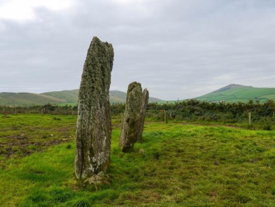
November 2014.
Image credit: Michael Mitchell
Meic
Jan 8, 2015
November 2014.
Image credit: Michael Mitchell
Meic
Jan 8, 2015
November 2014
Image credit: Michael Mitchell
Meic
Jan 8, 2015
Sites within 20km of
Keeltrasna
Kilcaskan
Standing Stone / Menhir
•
4.52km ESE
photo
1
Ballynahow Beg
Cup and Ring Marks / Rock Art
•
5.09km E
photo
3
forum
1
Cahergal
Stone Fort / Dun
•
6km SW
photo
7
description
1
Leacanabuile
Stone Fort / Dun
•
6.07km SW
photo
5
description
1
Cahersiveen
Standing Stone / Menhir
•
6.35km SSW
photo
3
Toon
Standing Stone / Menhir
•
8.36km E
photo
6
Caherlehillan
Stone Fort / Dun
•
8.41km E
photo
2
Caherlehillan South
Wedge Tomb
•
8.49km E
photo
4
Gortnagulla
Stone Row / Alignment
•
8.6km E
photo
3
Caherlehillan North
Wedge Tomb
•
8.6km E
photo
3
Oghermong
Standing Stone / Menhir
•
9.31km SSW
description
1
Glanleam
Standing Stone / Menhir
•
11.06km SW
photo
2
Kealduff (331)
Cup and Ring Marks / Rock Art
•
13.61km ENE
photo
4
Kealduff (334)
Cup and Ring Marks / Rock Art
•
13.71km ENE
photo
1
Kealduff (337)
Cup and Ring Marks / Rock Art
•
13.71km ENE
photo
1
Kealduff (333)
Cup and Ring Marks / Rock Art
•
13.72km ENE
photo
1
Coolnaharagill Upper
Cup and Ring Marks / Rock Art
•
13.9km ENE
photo
2
Kinard East
Cup and Ring Marks / Rock Art
•
14.2km N
photo
2
Coomasaharn
Cup and Ring Marks / Rock Art
•
14.24km ENE
photo
2
description
1
Cool East
Wedge Tomb
•
14.53km SW
photo
6
Aghacaribble 1
Cup and Ring Marks / Rock Art
•
14.74km N
photo
7
description
1
Doonmanagh (Puicin an Chairn)
Wedge Tomb
•
14.79km N
photo
9
description
3
Cool
Standing Stones
•
14.85km SW
photo
3
description
2
Minard
Wedge Tomb
•
15.14km N
photo
4
Foheraghmore
Standing Stone / Menhir
•
15.23km N
photo
4
Ardamore
Cup and Ring Marks / Rock Art
•
15.33km N
photo
5
description
1
Ardamore
Stone Row / Alignment
•
15.33km N
photo
13
description
1
Gallaunmore
Standing Stone / Menhir
•
15.91km NNW
photo
2
Graigue
Standing Stone / Menhir
•
15.91km N
photo
10
description
1
Lugnagappul
Cairn(s)
•
16.16km NNE
photo
3
Dromod
Stone Circle
•
16.67km SE
photo
3
Dingle
Bullaun Stone
•
16.95km NW
photo
4
description
2
Milltown
Standing Stone / Menhir
•
16.98km NW
photo
3
description
1
Milltown
Cup and Ring Marks / Rock Art
•
17.11km NW
photo
3
forum
1
description
1
Milltown
Standing Stone / Menhir
•
17.11km NW
photo
5
description
1
Fallen stones near Milltown Milestone
Standing Stones
•
17.15km NW
photo
6
description
1
Dunbeg
Cliff Fort
•
18.58km WNW
photo
23
forum
2
description
3
Caherard
Wedge Tomb
•
18.77km WNW
photo
5
description
1
Caher Conor
Stone Fort / Dun
•
19.06km WNW
photo
4
Waterville
Standing Stone / Menhir
•
19.25km SSE
photo
3
search
I’m looking for…
location_on
photo
ondemand_video
forum
description
link