Skip to content
Julian Cope
presents
The Modern
Antiquarian
Latest
Posts
Sites
Map
Blog
Forum
search
Search
⚠️
Sign in
more_horiz
Eire
County Kerry
Kinard East
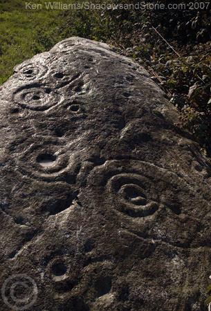
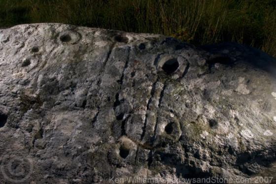
Cup and Ring Marks / Rock Art
V497992
expand_more
Nearest town:
Cahershiveen (20km S)
OS reference:
V497992
OS sheet:
70
Latitude:
52° 7' 27.74 N
Longitude:
10° 11' 41.66 W
Added to TMA by
CianMcLiam
Images (2)
Add
content
Images
Image credit: Ken Williams/ShadowsandStone.com 2007
CianMcLiam
Sep 10, 2007
Image credit: Ken Williams/ShadowsandStone.com 2007
CianMcLiam
Sep 10, 2007
Sites within 20km of
Kinard East
Foheraghmore
Standing Stone / Menhir
•
1.12km NNE
photo
4
Aghacaribble 1
Cup and Ring Marks / Rock Art
•
1.45km ENE
photo
7
description
1
Gallaunmore
Standing Stone / Menhir
•
2.52km WNW
photo
2
Ardamore
Stone Row / Alignment
•
2.61km ENE
photo
13
description
1
Ardamore
Cup and Ring Marks / Rock Art
•
2.61km ENE
photo
5
description
1
Doonmanagh (Puicin an Chairn)
Wedge Tomb
•
2.7km ENE
photo
9
description
3
Minard
Wedge Tomb
•
3km ENE
photo
4
Graigue
Standing Stone / Menhir
•
3.5km ENE
photo
10
description
1
Lugnagappul
Cairn(s)
•
4.61km ENE
photo
3
Dingle
Bullaun Stone
•
5.63km W
photo
4
description
2
Milltown
Cup and Ring Marks / Rock Art
•
6.94km W
photo
3
forum
1
description
1
Milltown
Standing Stone / Menhir
•
6.94km W
photo
5
description
1
Fallen stones near Milltown Milestone
Standing Stones
•
7km W
photo
6
description
1
Milltown
Standing Stone / Menhir
•
7.25km W
photo
3
description
1
An Choill Mhór (Kilmore)
Cist
•
8.87km NNE
photo
4
Baile Uí Uaithnín (Ballyhoneen)
Wedge Tomb
•
9.47km NNE
photo
4
Baile Uí Uaithnín (Ballyhoneen)
Standing Stone / Menhir
•
9.56km NNE
photo
3
An Choill Mhór (Kilmore)
Cup and Ring Marks / Rock Art
•
9.83km N
photo
3
Cnoc an Bhróigín Thiar
Cist
•
9.9km W
ondemand_video
1
Caherard
Wedge Tomb
•
10.74km W
photo
5
description
1
Caherdorgan North
Stone Fort / Dun
•
11.59km W
photo
5
description
1
Caherdorgan North
Standing Stone / Menhir
•
11.64km W
photo
1
Corr Aille Spiral
Cup and Ring Marks / Rock Art
•
11.79km WNW
photo
2
forum
1
description
1
link
1
Kilmalkedar
Bullaun Stone
•
11.9km WNW
photo
3
Kilmalkedar
Standing Stone / Menhir
•
12.32km WNW
photo
2
description
1
Cathair na bhFionnúrach
Stone Fort / Dun
•
13.32km WNW
photo
5
description
1
Cloonsharragh
Stone Row / Alignment
•
13.69km N
link
1
Keeltrasna
Standing Stone / Menhir
•
14.2km S
photo
3
Ballinrannig
Standing Stone / Menhir
•
14.57km W
photo
7
Dunbeg
Cliff Fort
•
14.86km WSW
photo
23
forum
2
description
3
Lougher
Cup and Ring Marks / Rock Art
•
15.02km ENE
photo
2
description
1
Caher Conor
Stone Fort / Dun
•
15.68km WSW
photo
4
Coolnaharagill Upper
Cup and Ring Marks / Rock Art
•
16.19km ESE
photo
2
Caherlehillan North
Wedge Tomb
•
16.87km SE
photo
3
Gortnagulla
Stone Row / Alignment
•
16.87km SE
photo
3
Caherlehillan South
Wedge Tomb
•
17.01km SE
photo
4
Caherlehillan
Stone Fort / Dun
•
17.2km SE
photo
2
Ballynahow Beg
Cup and Ring Marks / Rock Art
•
17.41km SSE
photo
3
forum
1
Kilcaskan
Standing Stone / Menhir
•
17.62km SSE
photo
1
Toon
Standing Stone / Menhir
•
18.06km SE
photo
6
Kealduff (333)
Cup and Ring Marks / Rock Art
•
18.12km ESE
photo
1
Kealduff (331)
Cup and Ring Marks / Rock Art
•
18.12km ESE
photo
4
Kealduff (337)
Cup and Ring Marks / Rock Art
•
18.19km ESE
photo
1
Kealduff (334)
Cup and Ring Marks / Rock Art
•
18.19km ESE
photo
1
Dunmore
Standing Stone / Menhir
•
19.05km WSW
photo
5
Leacanabuile
Stone Fort / Dun
•
19.09km S
photo
5
description
1
Cahergal
Stone Fort / Dun
•
19.2km S
photo
7
description
1
Coomasaharn
Cup and Ring Marks / Rock Art
•
19.39km ESE
photo
2
description
1
Knockbrack
Wedge Tomb
•
19.65km ENE
photo
4
description
1
Maumnahaltora
Wedge Tomb
•
19.78km ENE
photo
2
search
I’m looking for…
location_on
photo
ondemand_video
forum
description
link