Skip to content
Julian Cope
presents
The Modern
Antiquarian
Latest
Posts
Sites
Map
Blog
Forum
search
Search
⚠️
Sign in
more_horiz
Eire
County Cork
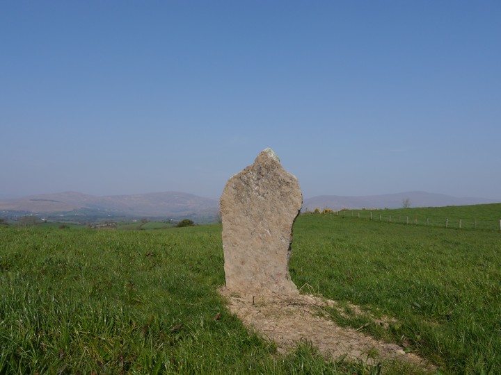
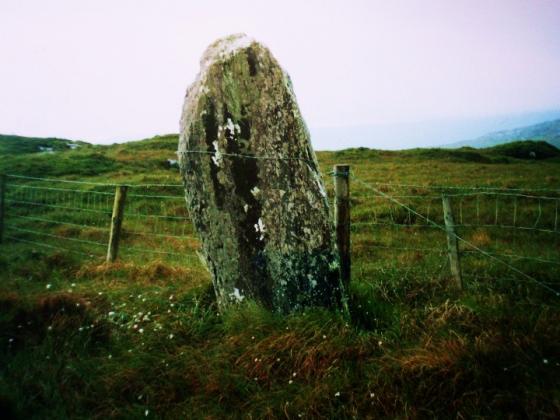
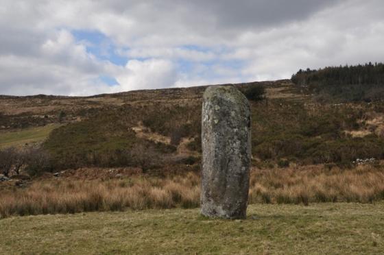
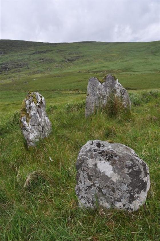
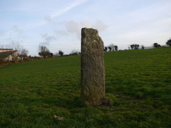
Shandrum Beg
Standing Stone / Menhir
W029527
expand_more
Nearest town:
Bantry (5km SW)
OS reference:
W029527
OS sheet:
85
Latitude:
51° 43' 6.43 N
Longitude:
9° 24' 18.78 W
Added to TMA by
Meic
Images (5)
Add
content
Images
29th March 2012
Image credit: Michael Mitchell
Meic
Mar 29, 2012
29th March 2012
Image credit: Michael Mitchell
Meic
Mar 29, 2012
29th March 2012
Image credit: Michael Mitchell
Meic
Mar 29, 2012
29th March 2012
Image credit: Michael Mitchell
Meic
Mar 29, 2012
29th March 2012
Image credit: Michael Mitchell
Meic
Mar 29, 2012
Sites within 20km of
Shandrum Beg
Cappanaboul
Stone Circle
•
0.71km NE
photo
7
Derryarkane
Stone Circle
•
2.5km ENE
Cloonygorman
Standing Stone / Menhir
•
2.91km E
photo
3
Glanbannoo Upper
Standing Stone / Menhir
•
3.17km ESE
photo
2
description
1
Breeny More
Stone Circle
•
3.26km NE
photo
26
description
4
Glanbannoo Upper
Standing Stone / Menhir
•
3.46km ESE
photo
5
description
2
Kealkil
Stone Circle
•
3.81km NE
photo
39
forum
1
description
5
link
1
Ardrah
Stone Row / Alignment
•
4.52km ENE
photo
18
description
2
Trawlebane
Stone Circle
•
5.06km SE
photo
13
description
2
Trawlebane 2
Standing Stone / Menhir
•
5.2km SSE
photo
5
Trawlebane 1
Standing Stone / Menhir
•
5.26km SE
photo
6
description
1
Mill Little
Stone Circle
•
5.5km WNW
photo
26
description
2
Knocknaveagh
Burial Chamber
•
5.56km SSW
photo
4
Baurgorm
Stone Circle
•
5.82km S
photo
11
Maughanasilly
Stone Row / Alignment
•
5.96km N
photo
20
description
3
Maughsilly
Stone Row / Alignment
•
5.99km N
link
1
Gortnacowly
Stone Circle
•
6.09km ENE
photo
13
forum
1
description
2
Scartbaun
Standing Stone / Menhir
•
6.57km SSW
photo
4
description
1
Toughraheen
Standing Stone / Menhir
•
6.59km ESE
photo
1
Baurgorm SW
Stone Circle
•
6.84km S
link
1
Gortnascreeny
Standing Stones
•
6.87km ESE
photo
4
description
1
Cahermuckee
Stone Row / Alignment
•
6.87km NE
photo
4
description
1
Cullomane West
Stone Row / Alignment
•
6.9km S
photo
9
description
1
Maughanaclea Centre
Stone Circle
•
6.98km ENE
photo
7
Illane
Stone Circle
•
7km N
photo
7
Inchybegga
Stone Circle
•
7.05km SE
photo
1
description
1
Derreengreanagh
Standing Stones
•
7.11km SSW
photo
10
description
1
Cullomane
Stone Circle
•
7.22km SSE
photo
8
description
2
Barnagowlane West
Wedge Tomb
•
7.25km ENE
photo
8
description
1
Scartbaun
Stone Row / Alignment
•
7.27km SSW
link
1
Cullomane East
Rath
•
7.31km SSE
photo
3
Cullomane East
Standing Stone / Menhir
•
7.32km SSE
photo
3
description
1
Cullomane East
Burial Chamber
•
7.41km SSE
photo
6
description
1
Cullomane East
Cairn(s)
•
7.41km SSE
photo
5
description
1
Cullomane East
Standing Stone / Menhir
•
7.41km SSE
photo
3
Dromore School
Standing Stone / Menhir
•
7.6km SE
photo
2
description
1
Beach
Standing Stone / Menhir
•
7.79km SW
photo
1
Keilnascarta NW
Stone Row / Alignment
•
8.3km SSW
photo
5
description
1
Caherogullane
Standing Stone / Menhir
•
8.32km S
photo
5
Maughanaclea NE
Stone Circle
•
8.34km ENE
photo
8
description
1
Keilnascarta
Stone Row / Alignment
•
8.39km SSW
photo
4
description
1
Keilnascarta SE
Stone Row / Alignment
•
8.49km SSW
photo
4
description
1
Dromclogh
Standing Stone / Menhir
•
8.68km SW
photo
5
Parkana
Standing Stones
•
9.07km SSW
photo
3
Cousane
Stone Circle
•
9.32km ENE
photo
9
description
1
Maulinward
Ring Cairn
•
9.66km SSW
photo
5
description
1
Maulinward
Stone Row / Alignment
•
9.66km SSW
photo
5
description
1
Dromourneen
Standing Stone / Menhir
•
9.69km SSE
photo
1
description
1
Derrynafinchin
Stone Circle
•
9.77km N
photo
14
description
2
Garranes North
Standing Stone / Menhir
•
9.9km E
photo
5
description
1
Cappaboy Beg
Stone Row / Alignment
•
9.9km NE
photo
4
Derrynafinchin
Standing Stones
•
9.95km N
photo
1
Cappaboy Beg
Standing Stone / Menhir
•
9.97km NE
photo
2
Cappaboy Beg NW
Stone Circle
•
10km NNE
photo
4
description
2
Cappaboy Beg
Ring Cairn
•
10.17km NE
photo
2
Cappaboy Beg
Standing Stone / Menhir
•
10.17km NE
photo
3
Cappaboy Beg SE
Stone Circle
•
10.25km NE
photo
6
description
1
Cousane
Standing Stone / Menhir
•
10.36km ENE
photo
3
description
1
Ballycommane
Stone Row / Alignment
•
10.51km SSW
photo
3
Ballycommane
Dolmen / Quoit / Cromlech
•
10.51km SSW
photo
2
Goulacullin
Standing Stone / Menhir
•
10.52km ENE
photo
3
description
1
Canrooska
Ancient Village / Settlement / Misc. Earthwork
•
10.66km W
photo
24
description
1
Rooska East
Standing Stone / Menhir
•
11.38km SW
photo
6
Barraboy Mountain N
Wedge Tomb
•
11.93km WNW
photo
5
description
1
Barraboy Mountain S
Wedge Tomb
•
11.93km WNW
photo
8
description
1
Barraboy Mountain
Cairn(s)
•
12.15km WNW
photo
3
Barraboy Mountain
Cairn(s)
•
12.15km WNW
photo
3
description
1
Cullenagh
Stone Circle
•
12.18km E
photo
10
description
1
Crossterry East
Standing Stone / Menhir
•
12.47km W
photo
7
Clodagh
Stone Circle
•
12.57km E
photo
18
description
1
Borlin Valley Standing Stone
Standing Stone / Menhir
•
12.59km N
photo
5
description
2
Clodagh Row
Stone Row / Alignment
•
12.72km E
photo
10
description
2
Feaghna
Bullaun Stone
•
12.78km NW
photo
7
description
3
Shronacarton
Standing Stone / Menhir
•
12.99km E
photo
6
Cullenagh
Stone Row / Alignment
•
13.05km ENE
photo
9
Baurnahulla
Dolmen / Quoit / Cromlech
•
13.28km ESE
photo
2
description
1
Farnanes
Standing Stone / Menhir
•
13.76km ENE
photo
8
description
1
Milleens
Souterrain
•
13.76km WNW
photo
3
Milleens
Bullaun Stone
•
13.8km WNW
photo
4
Lissangle
Standing Stone / Menhir
•
13.92km ESE
photo
5
Inchinanagh
Standing Stones
•
14.02km N
photo
6
Ballybane (The Rock of the Rings)
Cup and Ring Marks / Rock Art
•
14.02km S
photo
4
Ballybane West NW
Cup and Ring Marks / Rock Art
•
14.13km S
photo
5
Dooneens
Standing Stones
•
14.14km NE
photo
8
description
1
Cappaghmore
Standing Stone / Menhir
•
14.19km SSE
photo
6
Dooneens
Standing Stone / Menhir
•
14.26km NE
photo
4
Coolcoulaghta
Burial Chamber
•
14.57km SSW
photo
4
description
1
Bawnishall
Standing Stone / Menhir
•
15.4km SE
photo
2
description
1
Cullaba Lake
Standing Stones
•
15.78km NNW
photo
4
description
1
Derrynacoolagh
Cup and Ring Marks / Rock Art
•
15.88km WNW
photo
2
Western Pap
Passage Grave
•
15.96km NE
photo
7
description
2
Lissaclarig West
Stone Row / Alignment
•
16.02km SSE
photo
7
Murrahin North
Stone Row / Alignment
•
16.18km SSE
photo
12
description
1
Murrahin North
Standing Stone / Menhir
•
16.18km SSE
photo
8
Mount Corrin
Cairn(s)
•
16.2km SSW
photo
7
Derrynacaheragh
Standing Stone / Menhir
•
16.2km ENE
photo
1
description
1
Gortafludig
Wedge Tomb
•
16.27km NNE
Inchireagh
Stone Circle
•
16.46km ENE
photo
10
description
1
Dunbeacon
Stone Row / Alignment
•
16.51km SW
photo
5
description
1
Skeagh
Cairn(s)
•
16.74km SE
photo
3
Rathruane Beg
Standing Stone / Menhir
•
16.82km SSW
photo
4
Dunbeacon
Stone Circle
•
16.88km SW
photo
16
forum
1
description
4
Gurteen
Standing Stone / Menhir
•
17.05km NNW
photo
11
description
1
Lyre
Standing Stone / Menhir
•
17.08km SSE
photo
6
Gurteen
Stone Circle
•
17.24km NNW
photo
23
forum
1
description
1
Killenough
Standing Stone / Menhir
•
17.26km WSW
photo
4
description
1
Rathruane More
Burial Chamber
•
17.52km SSW
photo
6
Foherlagh
Stone Row / Alignment
•
17.57km SSE
photo
8
An Screathan Mór
Standing Stone / Menhir
•
17.8km NNE
photo
3
Leitrim Beg
Standing Stone / Menhir
•
18.04km WSW
photo
19
description
1
link
1
Cloghboola
Standing Stone / Menhir
•
18.04km SE
photo
5
Coolmountain
Stone Circle
•
18.14km ENE
photo
6
description
1
Keamcorravooly
Wedge Tomb
•
18.44km NE
photo
11
Keamcorravooly
Wedge Tomb
•
18.53km NE
photo
3
description
1
Ballynahowen
Wedge Tomb
•
18.56km WSW
photo
13
description
2
Grousemount
Stone Circle
•
18.82km NNE
photo
3
Derrynasafagh
Standing Stone / Menhir
•
18.96km ENE
photo
2
description
1
Currahy
Standing Stone / Menhir
•
19.19km NE
photo
4
Hollyhill
Standing Stone / Menhir
•
19.21km SSE
photo
5
Abbeystrowry
Standing Stone / Menhir
•
19.23km SE
photo
5
Reavouler
Standing Stone / Menhir
•
19.33km E
photo
13
description
1
Coolnagarrane
Standing Stone / Menhir
•
19.58km SE
photo
1
description
1
Dromroe
Stone Circle
•
19.64km WNW
photo
21
description
3
Dromatouk
Cairn(s)
•
19.89km NW
photo
1
Dromatouk
Standing Stone / Menhir
•
19.89km NW
photo
3
Dunmanway North
Standing Stone / Menhir
•
19.93km ENE
photo
5
Dromatouk
Stone Row / Alignment
•
19.94km NW
photo
8
Dromatouk
Stone Circle
•
19.99km NW
photo
20
description
2
search
I’m looking for…
location_on
photo
ondemand_video
forum
description
link