Skip to content
Julian Cope
presents
The Modern
Antiquarian
Latest
Posts
Sites
Map
Blog
Forum
search
Search
⚠️
Sign in
more_horiz
Eire
County Cork
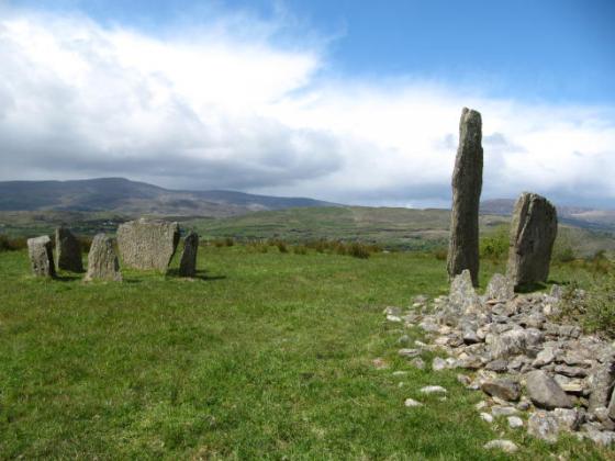
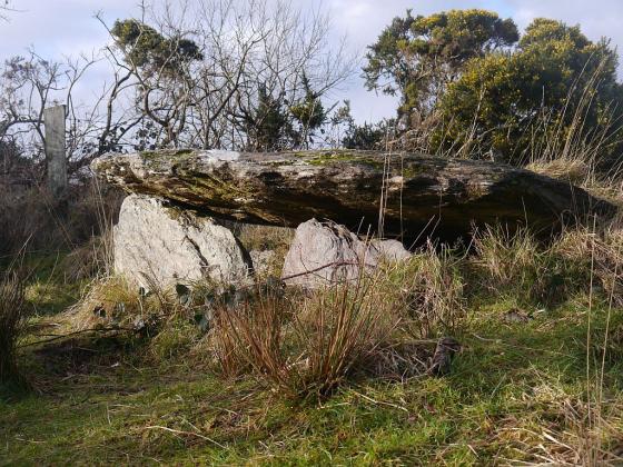
Ballybane (The Rock of the Rings)
Cup and Ring Marks / Rock Art
W018387
expand_more
Nearest town:
Ballydehob (5km SW)
OS reference:
W018387
OS sheet:
88
Latitude:
51° 35' 32.86 N
Longitude:
9° 25' 1.92 W
Added to TMA by
CianMcLiam
Sites (1)
Images (4)
Add
content
Sites within Ballybane (The Rock of the Rings)
•
location_on
photo
ondemand_video
forum
description
link
Images
29th January 2012
Image credit: Joanie Mitchell
Meic
Jan 29, 2012
29th January 2012
Image credit: Michael Mitchell
Meic
Jan 29, 2012
Image credit: Ken Williams/ShadowsandStone.com 2007
CianMcLiam
Nov 5, 2007
Image credit: Ken Williams/ShadowsandStone.com 2007
CianMcLiam
Nov 5, 2007
Sites within 20km of
Ballybane (The Rock of the Rings)
Ballybane West NW
Cup and Ring Marks / Rock Art
•
0.14km SW
photo
5
Cappaghmore
Standing Stone / Menhir
•
1.61km E
photo
6
Murrahin North
Stone Row / Alignment
•
2.46km SE
photo
12
description
1
Murrahin North
Standing Stone / Menhir
•
2.6km ESE
photo
8
Lissaclarig West
Stone Row / Alignment
•
2.97km ESE
photo
7
Dromourneen
Standing Stone / Menhir
•
4.49km NNE
photo
1
description
1
Lyre
Standing Stone / Menhir
•
5.12km E
photo
6
Foherlagh
Stone Row / Alignment
•
5.4km ESE
photo
8
Rathruane Beg
Standing Stone / Menhir
•
5.68km WSW
photo
4
Maulinward
Ring Cairn
•
5.76km NW
photo
5
description
1
Maulinward
Stone Row / Alignment
•
5.76km NW
photo
5
description
1
Caherogullane
Standing Stone / Menhir
•
5.81km NNW
photo
5
Skeagh
Cairn(s)
•
5.81km E
photo
3
Rathruane More
Burial Chamber
•
5.85km WSW
photo
6
Parkana
Standing Stones
•
5.88km NW
photo
3
Hollyhill
Standing Stone / Menhir
•
6.12km ESE
photo
5
Ballycommane
Stone Row / Alignment
•
6.44km WNW
photo
3
Ballycommane
Dolmen / Quoit / Cromlech
•
6.44km WNW
photo
2
Coolcoulaghta
Burial Chamber
•
6.77km W
photo
4
description
1
Keilnascarta SE
Stone Row / Alignment
•
6.77km NW
photo
4
description
1
Cullomane East
Burial Chamber
•
6.78km N
photo
6
description
1
Cullomane East
Cairn(s)
•
6.78km N
photo
5
description
1
Cullomane East
Standing Stone / Menhir
•
6.78km N
photo
3
Keilnascarta
Stone Row / Alignment
•
6.86km NW
photo
4
description
1
Cullomane East
Rath
•
6.9km N
photo
3
Cullomane East
Standing Stone / Menhir
•
6.93km N
photo
3
description
1
Keilnascarta NW
Stone Row / Alignment
•
6.95km NW
photo
5
description
1
Cullomane
Stone Circle
•
7km N
photo
8
description
2
Cullomane West
Stone Row / Alignment
•
7.19km NNW
photo
9
description
1
Derreengreanagh
Standing Stones
•
7.26km NNW
photo
10
description
1
Baurgorm SW
Stone Circle
•
7.28km NNW
link
1
Cappaghnacallee
Wedge Tomb
•
7.34km SW
description
1
Lisheen Lower
Dolmen / Quoit / Cromlech
•
7.39km SSE
photo
4
Scartbaun
Stone Row / Alignment
•
7.42km NNW
link
1
Mount Corrin
Cairn(s)
•
7.58km W
photo
7
Bawnishall
Standing Stone / Menhir
•
7.77km ENE
photo
2
description
1
Kilbronoge
Wedge Tomb
•
7.78km SW
photo
11
description
1
Inchybegga
Stone Circle
•
7.79km NNE
photo
1
description
1
Cloghboola
Standing Stone / Menhir
•
8.01km E
photo
5
Dromore School
Standing Stone / Menhir
•
8.1km NNE
photo
2
description
1
Scartbaun
Standing Stone / Menhir
•
8.15km NNW
photo
4
description
1
Baurgorm
Stone Circle
•
8.2km N
photo
11
Dunbeacon
Stone Row / Alignment
•
8.59km W
photo
5
description
1
Knocknaveagh
Burial Chamber
•
8.71km NNW
photo
4
Trawlebane 2
Standing Stone / Menhir
•
8.88km N
photo
5
Dunbeacon
Stone Circle
•
9.08km W
photo
16
forum
1
description
4
Trawlebane 1
Standing Stone / Menhir
•
9.2km N
photo
6
description
1
Inishbeg
Burial Chamber
•
9.23km ESE
photo
4
description
1
Lissangle
Standing Stone / Menhir
•
9.31km ENE
photo
5
Rathcool
Stone Row / Alignment
•
9.35km SW
photo
5
description
1
Trawlebane
Stone Circle
•
9.4km N
photo
13
description
2
Abbeystrowry
Standing Stone / Menhir
•
9.42km E
photo
5
Gortnascreeny
Standing Stones
•
9.48km NNE
photo
4
description
1
Rooska East
Standing Stone / Menhir
•
9.9km WNW
photo
6
Beach
Standing Stone / Menhir
•
10.23km NW
photo
1
Dromclogh
Standing Stone / Menhir
•
10.43km WNW
photo
5
Skull Stone
Standing Stone / Menhir
•
10.84km SW
photo
5
Coolnagarrane
Standing Stone / Menhir
•
11.26km E
photo
1
description
1
Toughraheen
Standing Stone / Menhir
•
11.57km NNE
photo
1
Glanbannoo Upper
Standing Stone / Menhir
•
12km NNE
photo
5
description
2
Glanbannoo Upper
Standing Stone / Menhir
•
12.26km NNE
photo
2
description
1
Barnabah
Cup Marked Stone
•
12.57km ESE
photo
2
Cloonygorman
Standing Stone / Menhir
•
12.99km NNE
photo
3
Ballymacrown
Standing Stone / Menhir
•
13km SE
photo
6
Baurnahulla
Dolmen / Quoit / Cromlech
•
13.48km ENE
photo
2
description
1
Shandrum Beg
Standing Stone / Menhir
•
14.02km N
photo
5
Inis Earcain (Sherkin Island)
Burial Chamber
•
14.47km S
photo
1
Cappanaboul
Stone Circle
•
14.57km N
photo
7
Inis Earcain (Sherkin Island)
Standing Stone / Menhir
•
14.58km S
photo
2
Garranes North
Standing Stone / Menhir
•
15.31km NE
photo
5
description
1
Derryarkane
Stone Circle
•
15.36km N
Gorteanish
Stone Circle
•
15.77km W
photo
11
description
2
link
1
Shronacarton
Standing Stone / Menhir
•
15.79km NE
photo
6
Arderawinny
Portal Tomb
•
16.33km WSW
photo
9
description
1
Ardrah
Stone Row / Alignment
•
16.54km NNE
photo
18
description
2
Breeny More
Stone Circle
•
16.78km N
photo
26
description
4
Gortnacowly
Stone Circle
•
17.07km NNE
photo
13
forum
1
description
2
Dunmanus
Burial Chamber
•
17.14km WSW
photo
2
description
1
Kilickaforavane
Passage Grave
•
17.15km SSW
description
1
link
1
Knockdrum
Stone Fort / Dun
•
17.16km E
photo
10
description
2
Kealkil
Stone Circle
•
17.18km N
photo
39
forum
1
description
5
link
1
Gurranes
Stone Row / Alignment
•
17.21km E
photo
22
forum
1
description
3
Clodagh
Stone Circle
•
17.42km NE
photo
18
description
1
Clodagh Row
Stone Row / Alignment
•
17.7km NE
photo
10
description
2
Altar
Wedge Tomb
•
17.97km WSW
photo
18
description
1
Toormore
Wedge Tomb
•
18.05km WSW
photo
13
forum
1
description
2
Dunmanus East
Standing Stone / Menhir
•
18.09km WSW
photo
2
description
1
Mill Little
Stone Circle
•
18.09km NNW
photo
26
description
2
Barnagowlane West
Wedge Tomb
•
18.35km NNE
photo
8
description
1
Cullenagh
Stone Circle
•
18.69km NE
photo
10
description
1
Gurteenaduige
Stone Row / Alignment
•
18.79km ENE
photo
7
description
1
Farranamanagh
Standing Stone / Menhir
•
18.83km WSW
photo
2
Reavouler
Standing Stone / Menhir
•
18.88km ENE
photo
13
description
1
Maughanaclea Centre
Stone Circle
•
18.95km NNE
photo
7
Goulacullin
Standing Stone / Menhir
•
19km NE
photo
3
description
1
Killinga
Cup Marked Stone
•
19.06km ENE
photo
5
description
1
Farranamanagh
Stone Row / Alignment
•
19.23km WSW
photo
5
description
1
Cahermuckee
Stone Row / Alignment
•
19.45km NNE
photo
4
description
1
Maughanaclea NE
Stone Circle
•
19.64km NNE
photo
8
description
1
Kilcrohane
Stone Row / Alignment
•
19.67km WSW
photo
9
Cullenagh
Stone Row / Alignment
•
19.82km NE
photo
9
Maughanasilly
Stone Row / Alignment
•
19.93km N
photo
20
description
3
Maughsilly
Stone Row / Alignment
•
19.96km N
link
1
Killenough
Standing Stone / Menhir
•
19.96km WNW
photo
4
description
1
search
I’m looking for…
location_on
photo
ondemand_video
forum
description
link