Skip to content
Julian Cope
presents
The Modern
Antiquarian
Latest
Posts
Sites
Map
Blog
Forum
search
Search
⚠️
Sign in
more_horiz
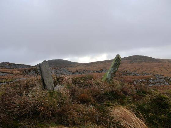
Eire
County Cork
Canrooska
Crossterry East
Standing Stone / Menhir
V926598
expand_more
Nearest town:
Bantry (13km ESE)
OS reference:
V926598
OS sheet:
85
Latitude:
51° 46' 49.34 N
Longitude:
9° 33' 23.08 W
Added to TMA by
Billy Fear
Sites (1)
Images (7)
Add
content
Sites within Crossterry East
•
location_on
photo
ondemand_video
forum
description
link
Images
5th March 2012
Image credit: Michael Mitchell
Meic
Mar 5, 2012
5th March 2012
Image credit: Michael Mitchell
Meic
Mar 5, 2012
5th March 2012
Image credit: Michael Mitchell
Meic
Mar 5, 2012
5th March 2012
Image credit: Michael Mitchell
Meic
Mar 5, 2012
5th March 2012
Image credit: Michael Mitchell
Meic
Mar 5, 2012
Looking SE.
50/2005
Image credit: Billy Fear
Billy Fear
Feb 23, 2009
Looking NE.
05/2005
Image credit: Billy Fear
Billy Fear
Feb 23, 2009
Sites within 20km of
Crossterry East
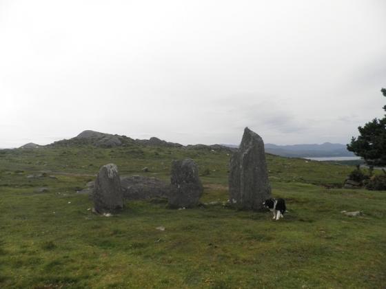
Barraboy Mountain N
Wedge Tomb
•
0.95km ENE
photo
5
description
1
Barraboy Mountain S
Wedge Tomb
•
0.95km ENE
photo
8
description
1
Barraboy Mountain
Cairn(s)
•
1.56km NE
photo
3
Barraboy Mountain
Cairn(s)
•
1.56km NE
photo
3
description
1
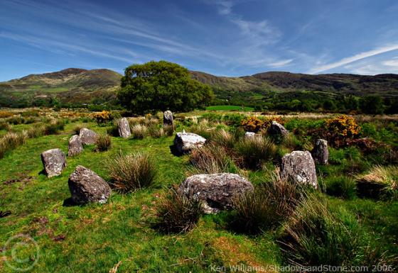
Canrooska
Ancient Village / Settlement / Misc. Earthwork
•
2.19km SE
photo
24
description
1
Milleens
Souterrain
•
4.23km NNE
photo
3
Milleens
Bullaun Stone
•
4.26km NNE
photo
4
Feaghna
Bullaun Stone
•
5.78km NE
photo
7
description
3
Derrynacoolagh
Cup and Ring Marks / Rock Art
•
5.99km N
photo
2
Mill Little
Stone Circle
•
7.13km E
photo
26
description
2
Dromroe
Stone Circle
•
7.4km WNW
photo
21
description
3
Uragh North
Stone Circle
•
9.89km W
photo
13
description
1
Uragh
Stone Circle
•
10.03km W
photo
33
description
5
Uragh West
Stone Circle
•
10.56km W
photo
9
description
3
Cullaba Lake
Standing Stones
•
10.74km NE
photo
4
description
1
Kenmare
Stone Circle
•
11.05km NNW
photo
15
description
4
Dromatouk
Cairn(s)
•
11.3km N
photo
1
Dromatouk
Standing Stone / Menhir
•
11.3km N
photo
3
Killenough
Standing Stone / Menhir
•
11.47km SW
photo
4
description
1
Dromatouk
Stone Circle
•
11.54km N
photo
20
description
2
Dromatouk
Stone Row / Alignment
•
11.59km N
photo
8
Leitrim Beg
Standing Stone / Menhir
•
11.63km SW
photo
19
description
1
link
1
Ballynahowen
Wedge Tomb
•
11.64km SW
photo
13
description
2
Maughanasilly
Stone Row / Alignment
•
11.73km E
photo
20
description
3
Dromatouk
Standing Stones
•
11.75km N
photo
10
Maughsilly
Stone Row / Alignment
•
11.82km E
link
1
Illane
Stone Circle
•
11.96km E
photo
7
Derrynafinchin
Standing Stones
•
12.4km ENE
photo
1
Derrynafinchin
Stone Circle
•
12.41km ENE
photo
14
description
2
Shandrum Beg
Standing Stone / Menhir
•
12.47km E
photo
5
Gurteen
Standing Stone / Menhir
•
12.56km NE
photo
11
description
1
Cappanaboul
Stone Circle
•
12.62km E
photo
7
Gurteen
Stone Circle
•
12.71km NE
photo
23
forum
1
description
1
Beach
Standing Stone / Menhir
•
12.82km SE
photo
1
Dromclogh
Standing Stone / Menhir
•
12.84km SE
photo
5
Kildromalive
Standing Stone / Menhir
•
13.1km SW
photo
4
description
1
Kilcaskan
Stone Row / Alignment
•
13.11km SW
photo
4
description
1
Breeny More
Stone Circle
•
13.18km E
photo
26
description
4
Inchinanagh
Standing Stones
•
13.2km ENE
photo
6
Kealkil
Stone Circle
•
13.55km E
photo
39
forum
1
description
5
link
1
Drombohilly Wedge Tomb
Wedge Tomb
•
13.57km W
photo
1
description
1
Drombohilly
Stone Circle
•
13.58km W
photo
27
forum
3
description
5
Borlin Valley Standing Stone
Standing Stone / Menhir
•
13.62km ENE
photo
5
description
2
Lehid
Dolmen / Quoit / Cromlech
•
13.87km W
photo
1
Cappaleigh North
Standing Stone / Menhir
•
13.91km SW
photo
3
description
1
Derryarkane
Stone Circle
•
13.95km E
Drumlave
Stone Row / Alignment
•
13.97km SW
photo
10
description
1
Lehid
Standing Stone / Menhir
•
14.07km W
photo
3
Lehid
Wedge Tomb
•
14.45km W
photo
2
Clogherane
Standing Stone / Menhir
•
14.47km WSW
photo
3
Clogherane
Stone Row / Alignment
•
14.53km WSW
photo
3
Rooska East
Standing Stone / Menhir
•
14.68km SSE
photo
6
Knocknaveagh
Burial Chamber
•
15.06km ESE
photo
4
Scartbaun
Standing Stone / Menhir
•
15.11km SE
photo
4
description
1
Cloonygorman
Standing Stone / Menhir
•
15.37km E
photo
3
Ardrah
Stone Row / Alignment
•
15.42km E
photo
18
description
2
Cappaboy Beg NW
Stone Circle
•
15.49km ENE
photo
4
description
2
Glanbannoo Upper
Standing Stone / Menhir
•
15.61km ESE
photo
2
description
1
Rossacoosane
Cup and Ring Marks / Rock Art
•
15.65km NW
photo
1
Scartbaun
Stone Row / Alignment
•
15.76km SE
link
1
Cahermuckee
Stone Row / Alignment
•
15.77km E
photo
4
description
1
Glanbannoo Upper
Standing Stone / Menhir
•
15.87km ESE
photo
5
description
2
Reenkilla
Stone Circle
•
15.88km WSW
photo
4
description
1
Keilnascarta NW
Stone Row / Alignment
•
16.03km SE
photo
5
description
1
Baurgorm
Stone Circle
•
16.1km ESE
photo
11
Derreengreanagh
Standing Stones
•
16.11km SE
photo
10
description
1
Keilnascarta
Stone Row / Alignment
•
16.13km SE
photo
4
description
1
Trawlebane 2
Standing Stone / Menhir
•
16.13km ESE
photo
5
Keilnascarta SE
Stone Row / Alignment
•
16.22km SE
photo
4
description
1
Baurgorm SW
Stone Circle
•
16.41km ESE
link
1
Cullomane West
Stone Row / Alignment
•
16.58km ESE
photo
9
description
1
Maughanaclea Centre
Stone Circle
•
16.61km E
photo
7
Trawlebane
Stone Circle
•
16.65km ESE
photo
13
description
2
Cappaboy Beg
Stone Row / Alignment
•
16.74km ENE
photo
4
Trawlebane 1
Standing Stone / Menhir
•
16.79km ESE
photo
6
description
1
Cappaboy Beg
Standing Stone / Menhir
•
16.84km ENE
photo
2
Ballycommane
Stone Row / Alignment
•
16.93km SE
photo
3
Ballycommane
Dolmen / Quoit / Cromlech
•
16.93km SE
photo
2
Cappaboy Beg
Ring Cairn
•
17.04km ENE
photo
2
Cappaboy Beg
Standing Stone / Menhir
•
17.04km ENE
photo
3
Cappaboy Beg SE
Stone Circle
•
17.04km ENE
photo
6
description
1
Gortnacowly
Stone Circle
•
17.05km E
photo
13
forum
1
description
2
Parkana
Standing Stones
•
17.11km SE
photo
3
Maulinward
Ring Cairn
•
17.24km SE
photo
5
description
1
Maulinward
Stone Row / Alignment
•
17.24km SE
photo
5
description
1
Caherogullane
Standing Stone / Menhir
•
17.61km SE
photo
5
Barnagowlane West
Wedge Tomb
•
17.62km E
photo
8
description
1
Shronebirrane
Stone Circle
•
17.69km WSW
photo
19
description
3
Coomgira
Standing Stone / Menhir
•
17.77km SW
photo
6
Cashelkeelty SE
Stone Circle
•
17.85km WSW
photo
12
description
1
Cullomane
Stone Circle
•
17.94km ESE
photo
8
description
2
Cashelkeelty NW
Stone Circle
•
17.96km WSW
photo
10
description
2
Cullomane East
Rath
•
18.02km ESE
photo
3
Cullomane East
Burial Chamber
•
18.04km ESE
photo
6
description
1
Cullomane East
Cairn(s)
•
18.04km ESE
photo
5
description
1
Cullomane East
Standing Stone / Menhir
•
18.04km ESE
photo
3
Maughanaclea NE
Stone Circle
•
18.05km E
photo
8
description
1
Cullomane East
Standing Stone / Menhir
•
18.08km ESE
photo
3
description
1
Inchybegga
Stone Circle
•
18.45km ESE
photo
1
description
1
Cousane
Stone Circle
•
18.87km E
photo
9
description
1
Gortnascreeny
Standing Stones
•
18.98km ESE
photo
4
description
1
Toughraheen
Standing Stone / Menhir
•
19.04km ESE
photo
1
Dromore School
Standing Stone / Menhir
•
19.33km ESE
photo
2
description
1
Coolcoulaghta
Burial Chamber
•
19.64km SSE
photo
4
description
1
Dromourneen
Standing Stone / Menhir
•
19.77km ESE
photo
1
description
1
Dooneens
Standing Stones
•
19.96km ENE
photo
8
description
1
search
I’m looking for…
location_on
photo
ondemand_video
forum
description
link