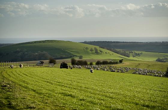
The Modern Antiquarian
Log in
|
Register
Home
Latest Posts
Forums
Maps
Help
Browse Sites
News
Blog
Contributors
The Books
Select
-
Belgium
Denmark
Eire
France
Germany
Greece
Italy
The Netherlands
Norway
Portugal
Republic of Malta
Spain
Sweden
Switzerland
United Kingdom
England
Southern England
West Sussex
Newtimber Hill
Round Barrow(s)
Newtimber Hill (Round Barrow(s)) on The Modern Antiquarian, the UK & Ireland's most popular megalithic community website. 2 images, plus information on many more ancient sites nearby and across the UK & Ireland.
Image © A R Cane
Nearest Town:
Hove (7km SSE)
OS Ref (GB):
TQ2712 /
Sheet: 198
Latitude:
50° 53' 34.47" N
Longitude:
0° 11' 38.47" W
Added by
A R Cane
Images (2)
0 discussions
Start a topic
Show |
Hide
Web searches for Newtimber Hill
Flickr
Google
Google Images
MAGIC
The Megalithic Portal
Bing
Stone Pages
Streetmap.co.uk
Wikipedia
Show map
(inline Google Map)
- Sites within 20 km -
-
North Hill (0.1km W) (3 posts)
Devil's Dyke (West Sussex) (1.22km SW) (14 posts)
Wolstonbury Platform Barrow (2.12km NE) (1 post)
Wolstonbury Cross Ridge Dyke (2.12km NE) (2 posts)
Wolstonbury Bowl Barrow (2.12km NE) (10 posts)
Wolstonbury Barrows (2.12km NE) (1 post)
Wolstonbury (2.22km NE) (34 posts)
Fulking Hill (2.54km WSW) (1 post)
Edburton Hill (3.85km WSW) (3 posts)
Brighton bypass Henge (4.65km SSW) (1 post)
Tegdown Hill Barrows (4.69km E) (2 posts)
Thundersbarrow Hill (5.51km SW) (7 posts)
Rest And Be Thankful (5.87km SW) (6 posts)
Pudding Bag Wood Prehistoric Linear Boundary (6.02km E) (2 posts)
Pudding Bag Wood Bowl Barrow (6.07km E) (3 posts)
The Goldstone (6.23km SSE) (18 posts)
Ditchling Beacon (6.26km ENE) (10 posts)
Bowl Barrow in Great Wood (6.34km E) (0 posts)
Hollingbury Hillfort (6.67km ESE) (23 posts)
Cross dyke in Great Wood (6.69km E) (0 posts)
The Steyning Stone (9.18km WSW) (4 posts)
Whitehawk Camp (9.42km ESE) (13 posts)
Plumpton Plain (9.78km ENE) (5 posts)
Steep Down (11.5km WSW) (5 posts)
Castle Hill (Woodingdean) (11.95km E) (5 posts)
Kingston Barrow Cemetery (12.27km E) (5 posts)
Offham Hill (12.86km E) (8 posts)
Chanctonbury Ring (13.05km W) (40 posts)
Beacon Hill (13.12km ESE) (1 post)
Cissbury Ring (13.56km WSW) (41 posts)
Brack Mount (14.46km E) (3 posts)
The Tump, Lewes (14.65km E) (27 posts)
Cliffe Hill (16.07km E) (5 posts)
Church Hill Flint Mines (16.17km WSW) (3 posts)
Ranscombe Camp (17.01km E) (12 posts)
Saxon Down (17.5km E) (3 posts)
Money Burgh (17.53km E) (1 post)
Sullington Hill (17.54km W) (5 posts)
Mount Caburn (17.61km E) (29 posts)
Sullington Warren (17.62km W) (8 posts)
Blackpatch Flint Mines (17.81km WSW) (5 posts)
Chantry Hill (18.34km W) (3 posts)
Harrow Hill (18.94km WSW) (12 posts)
Highdown Hill (19.2km WSW) (19 posts)
Kithurst Hill (19.34km W) (10 posts)
Peacehaven Heights (19.92km ESE) (1 post)
- Facilities within 20 km -
-
Devils Dyke Hotel (Hotel: 1.6 km SW)
The Jack and Jill Inn (Pub: 3.6 km NE)
Truleigh Hill (Youth Hostel: 5.1 km WSW)
The Jugg's Arms (Pub: 12.9 km E)
Barbican House Museum ... (Museum: 14.5 km E)
Trevor Arms (Pub: 19.1 km E)
- Add -
-
Add news
Add an image
Add fieldnotes
Add folklore
Add miscellaneous
Add a link
-
Add a site
Add a nearby facility
Add an alternative name/spelling
Images
(click to view fullsize)
Add an image