
From William Borlase’s ‘Antiquities, historical and monumental, of the county of Cornwall’ (1695).
Image credit: .
From William Borlase’s ‘Antiquities, historical and monumental, of the county of Cornwall’ (1695).
archive.org/stream/ancientcrossesot00blig#page/n146/mode/1up
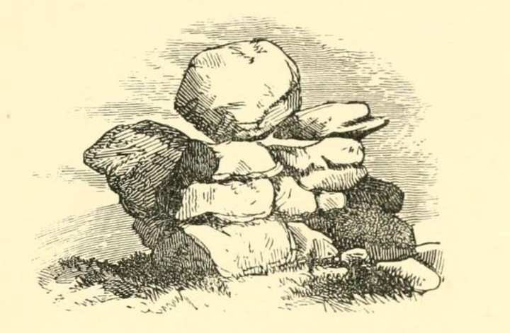
“This stone is in the parish of Sithney, on the property of C.W. Popham, Esq., of Trevarno. It was formerly a logan-stone, but was thrown off its balance in the time of Cromwell, by Shrubshall, then governor of Pendennis. – The stone is 11 feet long from east to west; depth 4 feet. Men Amber is a corruption of Men-an-bar, which signifies, the top stone.”

Methodists at Men Amber

The Men Amber looms right, with the hollow way dropping off the ridge towards Tregonning Hill behind my compatriot; Mounts Bay silvering in the distance, 3rd November 2006 ce

A close up of the northerly aspect of Men Amber, 3rd November 2006 ce
An odd one this...in that I’d been for many years aware of the feature from afar without ever really being able to place it satisfactorily in close up. Men Amber is a granite tor on the most westerly rise of the Carnmenellis granite, and viewed from northerly aspects comprises a readily identifiable outcrop on a long low ridge that also comprises Crowan Beacon, Polcrebo Downs, Longstone Downs (see below) and Prospidnick Hill before the land drops towards the Cober valley and the Lizard. It is the only granite tor visible along this otherwise relatively smooth ridge from a north-westerly direction, and is plainly visible from the North Cliffs and thus sites such as Crane Castle 11km distant.
The tor is very much of the classic ‘stacked’ formation rather than a crag, and thus is quite possibly the site of a logan stone I have seen reference to in Cornish antiquarian literature as ‘being near to Nancegollan’.
It is also at the crossroads of two tracks of arguably great antiquity: firstly a ridgeway slightly bowdlerized by subsequent enclosure running broadly south from Black Rock (adjacent to the cairn and fire summit at Crowan Beacon) along the ridge a modern field’s width behind the tor across Longstone Downs; within a couple of hundred yards of Prospidnick Longstone, then just east of the summit of Prospidnick Hill, before becoming a minor road and dropping gradually into the valley of the River Cober to the erstwhile (medieval at least) tidal limit of that river at Helston St. Johns; secondly a mostly intact track which seemingly originated at Tregonning Hill, across NW through Carleen before becoming a hollow way on the direct incline up immediately past Men Amber. East from here a sequence of now unclassified minor roads lead in an almost direct easterly bearing across the Carnmenellis uplands to Porkellis, Longdowns and eventually Mabe Burnthouse above the River Fal.
I need to do some more fieldwork and sight bearings on this one, but am sure it is usefully sightlined with Tregonning Hill, and indeed even as far as the foothills of Penwith looking NW. The shout goes out – calling Mr. Hamhead?!?
To the Editor of the West Briton. [...] In the year 1851 I was induced to visit Prospidnick village and hill, particularly the latter, by reading in Norden’s Speculi Britanniae Pars, &c., 1584, an account, accompanied by an engraving, of a singular mass of rocks that is in the neighbourhood; and, on making inquiries, was informed that Men Amber was still in existence, but not in the same state as when sketched by Norden, whose description is here given verbatim: “Mayne Amber, certain huge stones so sett and subtillye combined, not by art as I take it, but by nature, as a childe may move, the upper stone beinge of a huge bignes, with one finger, so equallie balanced it is, and the forces of menie strong men enjoyned, can do no more in moving it. It is to be imagined that theis stones were thus lefte at the general floude, when the earth was washed awaye, and the massie stones remayned, as are mightye rockes uncovered, standing upon lofty hills.” The following is from Carew, 1602:- “More certain though less wonderful, and yet for the strangeness well worth the viewing, Mayn Amber is a rock; Amber as some say signyfieth Ambrose, and a great rock the same is, advanced upon some others of a meaner size, with so equal a counterpoise, that the push of a finger will sensibly move it to and fro, but further to remove it the united forces of many shoulders over weak. Wherefore the Cornish wonder-gatherer thus describeth the same:-- “Be those thy mother Nature’s work, Or proof of Giant’s might, Worthless and ragged though thou show, Yet art thou worth the sight. This hugy rock one finger’s force Apparently will move, But to remove it many strengths Shall all like feeble prove.” Mr. Scawen, whose family had been established for a long time at Molenick, in St. Germans, tells us in his MSS., written in the latter part of the 17th century, when and by whom this logan stone was thrown down. Complaining of the mischief done by strangers, he writes:- “Here, too, we may add what wrong another sort of strangers has done to us, especially in the civil wars, and in particular by destroying Mineamber, a famous monument, being a rock of infinite weight, which as a burden was laid upon other great stonesn; and yet so equally thereon poised up by Nature only, as a little child could instantly move it, but no one man or many remove it. This natural monument all travellers that came that way desired to behold, but in the time of Oliver’s usurpation, when all monumental things became despicable, one Shrubsall, one of Oliver’s heroes, then governor of Pendennis, by labour and much ado caused to be undermined and thrown down, to the great grief of the country, but to his own great glory as he thought, doing it, as he said, with a small cane in his hand. I myself have heard him boast of this act, being a prisoner then under him.” There was a tradition or prophecy, current at the time, that Mineamber, so called by Scawen, should stand as long as England had a king; its overthrow by Shrubsall seems to have been for the purpose of showing the loyal Cornish that kings were to reign no longer. Borlase’s account is as follows:- “In the parish of Sithney stood the famous Logan stone, commonly called Men-amber; it is 11 foot long from east to west, four foot deep, wide six foot; there is no bason on the surface, but on the stone B there is one plain one. This top stone was so nicely poised that, as Mr. Seawen in his MSS. says, &c. There are some marks of the tool upon this stone, the surface, C D, being wrought into a wavy place, as in the Icon; and by its quadrangular shape I should judge it to have been dedicated to Mercury, as by a bason cut in the under stone B, I judge the stone A to be placed on the top of this karn by human art. However that be, certain it is that the vulgar used to resort to this place at particular times of the year, and pay’d to this stone more respect than was thought becoming good christians, which was the reason that by cleaving off part of the stone B, the top stone A was lay’d along in its present reclined posture and its wonderful property of moving easily to a certain point destroyed. It was the top stone, therefore, of this Cragg which drew the common people together and raised their admiration; and I find that in the Cornish language Mea-an-bar signifies the top stone, and I do not at all doubt but that Men-amber is a corruption of Men-an-bar, and signifies nothing either relating to Ambrosius Aurelius, King of Britain, or to the Petrae Ambrosiae of the Ancients, as some learned men have thought.” – Antiquities, 1754. The letters in the last extract refer to a plan of the rock.[...] Yours obediently,From a letter in the West Briton newspaper, 20th January 1870. He signs himself as a capital Delta. I guess the 1870 equivalent of an internet name perhaps?!Δ
In the Parish of Sithney, stood the famous Logan-stone, called Men-amber, which is 11 Feet long from East to West, 4 Feet deep, and 6 Feet wide. This top Stone was so nicely poised, that, “a little Child, as Mr. Scawen in his M.S. says, could instantly move it;” but in the Time of Cromwell, when all monumental and curious Pieces of Antiquity, that Ignorance and fiery Zeal deemed superstitious, not only grew into Contempt, but which it was reckoned a Mark of Piety to deface or destroy, one Shrubsall, Governor of Pendennis, with much ado, caused it to be undermined and thrown down, to the great Grief of the Country.
From The Natural history of England by Benjamin Martin (1759).
Speed describes this monument in the following manner: “But neere Pensans and unto Mounts Bay, a farre more strange Rocke standeth, namely, Main-Amber, which lieth mounted upon others of a meaner size, with so equal a counterpoise, that a man may move it with the point of his finger, but no strength remove it out of his place.”
(I assume ‘Speed’ is John Speed, the cartographer ((1552-1629) but I could be completely wrong). This from ‘An Historical Survey of the County of Cornwall‘
google.co.uk/books?id=KcYMAAAAYAAJ&pg=PA213


