Skip to content
Julian Cope
presents
The Modern
Antiquarian
Latest
Posts
Sites
Map
Blog
Forum
search
Search
⚠️
Sign in
more_horiz
Eire
County Cork
Ballymacrown
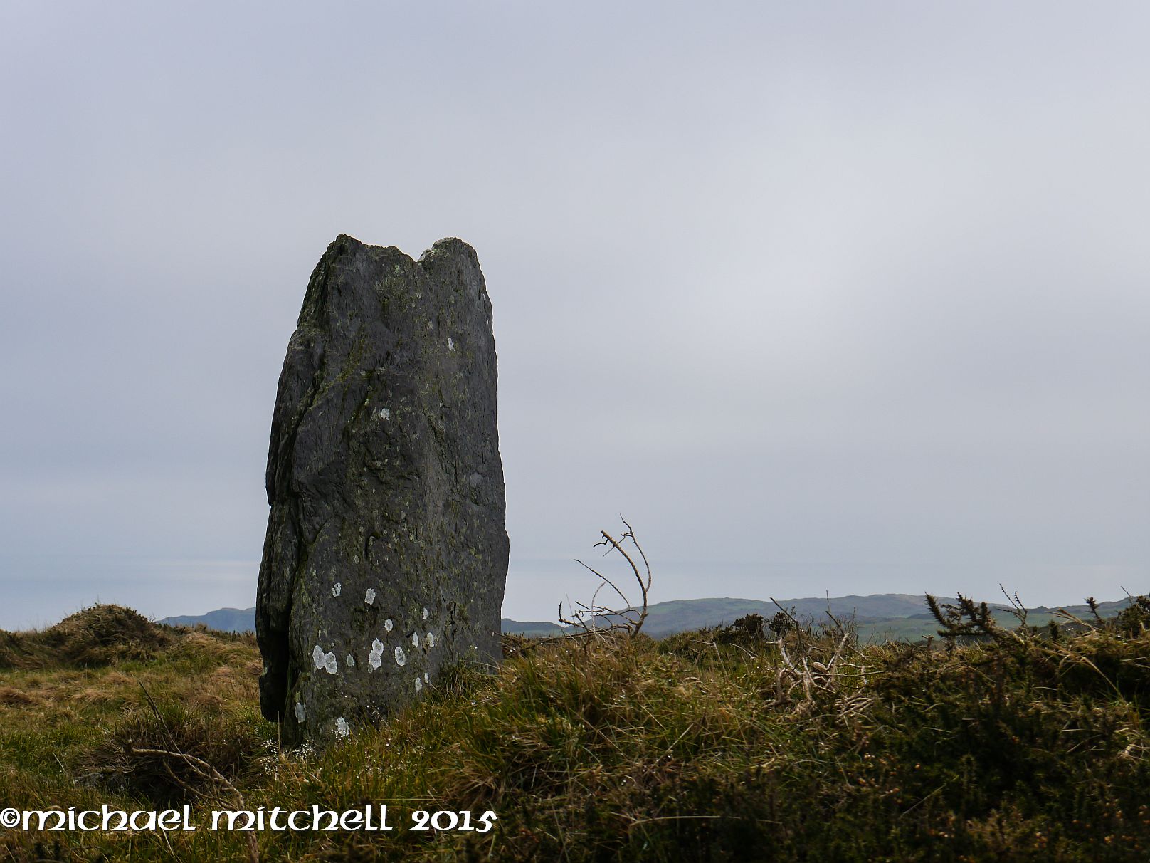
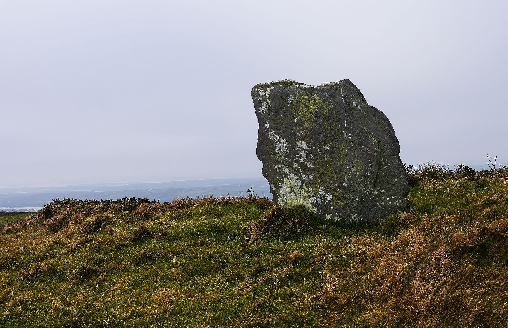
Standing Stone / Menhir
W073269
expand_more
Nearest town:
Baltimore (2km WSW)
OS reference:
W073269
OS sheet:
88
Latitude:
51° 29' 14.48 N
Longitude:
9° 20' 5.08 W
Added to TMA by
Meic
Images (6)
Add
content
Images
February 2015
Image credit: Michael Mitchell
Meic
Feb 9, 2015
February 2015
Image credit: Michael Mitchell
Meic
Feb 9, 2015
February 2015
Image credit: Michael Mitchell
Meic
Feb 9, 2015
February 2015
Image credit: Michael Mitchell
Meic
Feb 9, 2015
February 2015
Image credit: Michael Mitchell
Meic
Feb 9, 2015
February 2015
Image credit: Michael Mitchell
Meic
Feb 9, 2015
Sites within 20km of
Ballymacrown
Barnabah
Cup Marked Stone
•
2.48km NE
photo
2
Inishbeg
Burial Chamber
•
3.96km NNW
photo
4
description
1
Lisheen Lower
Dolmen / Quoit / Cromlech
•
5.95km WNW
photo
4
Hollyhill
Standing Stone / Menhir
•
7.01km NW
photo
5
Inis Earcain (Sherkin Island)
Burial Chamber
•
7.53km WSW
photo
1
Inis Earcain (Sherkin Island)
Standing Stone / Menhir
•
7.66km WSW
photo
2
Foherlagh
Stone Row / Alignment
•
8.57km NNW
photo
8
Abbeystrowry
Standing Stone / Menhir
•
8.7km NNE
photo
5
Lyre
Standing Stone / Menhir
•
9.07km NNW
photo
6
Cloghboola
Standing Stone / Menhir
•
9.11km N
photo
5
Skeagh
Cairn(s)
•
9.59km NNW
photo
3
Coolnagarrane
Standing Stone / Menhir
•
10.3km NNE
photo
1
description
1
Lissaclarig West
Stone Row / Alignment
•
10.32km NW
photo
7
Murrahin North
Standing Stone / Menhir
•
10.42km NW
photo
8
Murrahin North
Stone Row / Alignment
•
10.54km NW
photo
12
description
1
Knockdrum
Stone Fort / Dun
•
10.68km ENE
photo
10
description
2
Gurranes
Stone Row / Alignment
•
11.15km ENE
photo
22
forum
1
description
3
Kilickaforavane
Passage Grave
•
11.19km WSW
description
1
link
1
Cappaghnacallee
Wedge Tomb
•
11.49km W
description
1
Kilbronoge
Wedge Tomb
•
12.01km W
photo
11
description
1
Bawnishall
Standing Stone / Menhir
•
12.1km N
photo
2
description
1
Cappaghmore
Standing Stone / Menhir
•
12.22km NW
photo
6
Ballybane West NW
Cup and Ring Marks / Rock Art
•
12.95km NW
photo
5
Ballybane (The Rock of the Rings)
Cup and Ring Marks / Rock Art
•
13km NW
photo
4
Rathruane More
Burial Chamber
•
14.42km WNW
photo
6
Rathcool
Stone Row / Alignment
•
14.49km W
photo
5
description
1
Skull Stone
Standing Stone / Menhir
•
14.69km W
photo
5
Lissangle
Standing Stone / Menhir
•
14.7km N
photo
5
Rathruane Beg
Standing Stone / Menhir
•
15.03km WNW
photo
4
Carrigillihy
Cup Marked Stone
•
15.3km ENE
photo
8
description
1
Carrigillihy
Standing Stones
•
15.38km ENE
photo
6
Dromourneen
Standing Stone / Menhir
•
16.61km NW
photo
1
description
1
Mount Corrin
Cairn(s)
•
17.78km WNW
photo
7
Coolcoulaghta
Burial Chamber
•
18.01km WNW
photo
4
description
1
Gurteenaduige
Stone Row / Alignment
•
18.11km NE
photo
7
description
1
Caherogullane
Standing Stone / Menhir
•
18.53km NW
photo
5
Killacoosane
Standing Stone / Menhir
•
18.55km ENE
photo
6
Dunbeacon
Stone Row / Alignment
•
18.72km WNW
photo
5
description
1
Maulinward
Ring Cairn
•
18.75km NW
photo
5
description
1
Maulinward
Stone Row / Alignment
•
18.75km NW
photo
5
description
1
Cullomane East
Burial Chamber
•
18.78km NNW
photo
6
description
1
Cullomane East
Cairn(s)
•
18.78km NNW
photo
5
description
1
Cullomane East
Standing Stone / Menhir
•
18.78km NNW
photo
3
Dromore School
Standing Stone / Menhir
•
18.83km NNW
photo
2
description
1
Cullomane East
Standing Stone / Menhir
•
18.84km NNW
photo
3
description
1
Cullomane East
Rath
•
18.86km NNW
photo
3
Parkana
Standing Stones
•
18.86km NW
photo
3
Cullomane
Stone Circle
•
18.96km NNW
photo
8
description
2
Dunbeacon
Stone Circle
•
19.04km WNW
photo
16
forum
1
description
4
Inchybegga
Stone Circle
•
19.14km NNW
photo
1
description
1
Baurnahulla
Dolmen / Quoit / Cromlech
•
19.19km NNE
photo
2
description
1
Drombeg
Stone Circle
•
19.21km ENE
photo
47
forum
1
description
8
link
2
Ballycommane
Stone Row / Alignment
•
19.27km NW
photo
3
Ballycommane
Dolmen / Quoit / Cromlech
•
19.27km NW
photo
2
Killinga
Cup Marked Stone
•
19.28km NE
photo
5
description
1
Ballyroe
Dolmen / Quoit / Cromlech
•
19.5km NE
photo
7
description
1
Keilnascarta SE
Stone Row / Alignment
•
19.75km NW
photo
4
description
1
Cullomane West
Stone Row / Alignment
•
19.78km NW
photo
9
description
1
Keilnascarta
Stone Row / Alignment
•
19.85km NW
photo
4
description
1
Baurgorm SW
Stone Circle
•
19.91km NW
link
1
Keilnascarta NW
Stone Row / Alignment
•
19.94km NW
photo
5
description
1
Gortnascreeny
Standing Stones
•
19.99km NNW
photo
4
description
1
search
I’m looking for…
location_on
photo
ondemand_video
forum
description
link