|
|
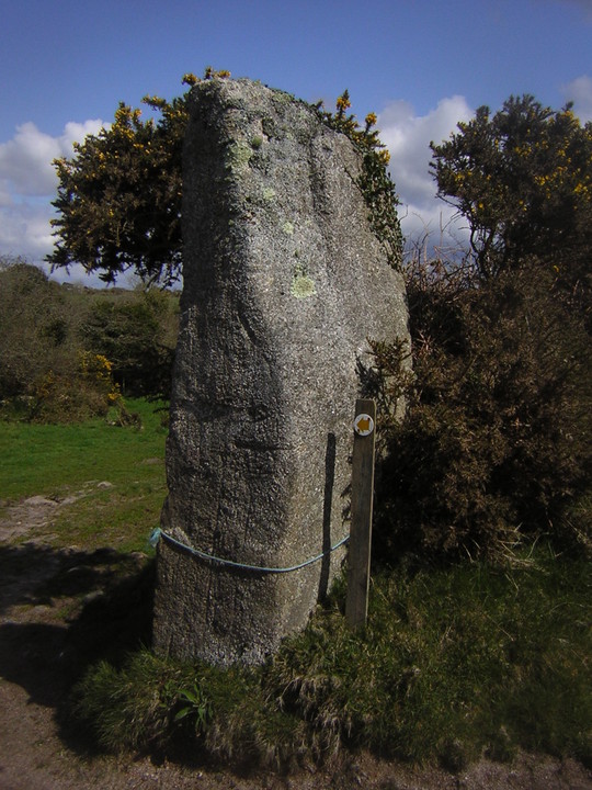
I think this is definitely a hitherto unrecorded menhir - and a gurt beauty it is too! Noticed it on a meander around the lesser known paths of the northern Carnmenellis district just last week. Some 7 feet high and more than 4 feet broad, it nestles near the boundary of Stithians and Lanner parishes on an underused and occasionally thicketed footpath down from the nearby Carvannel Farm - thought it was only fair to name it so.
|

|
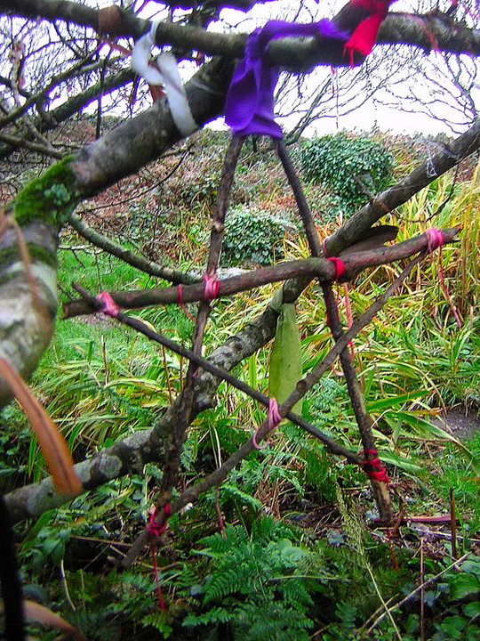
GARRACK ZANS - VILLAGE RITUAL STONES
Whilst scouring my lil' collection of Cornish literature for any interesting references to visits, folklore &c, I found the following in William Bottrell's "Traditions and Hearthside Stories of West Cornwall (2nd series)". referencing a tradition of meeting stones, known as Garrack Zans: it doesn't have any proveable prehistory but looks damn likely to be a really late survivor of megalithic tradition, and thus very much of interest; brackets are mine.
"Within the memory of many persons now living, there was to be seen, in the town-places of many western villages, an unhewn table like stone called the Garrack Zans. This stone was the usual meeting place of the villagers, and regarded by them as public property. Old residents in Escols (Escalls, near Sennen) have often told me of one which stood near the centre of that hamlet on an open space...(this) they described as nearly round, about three feet high, and nine in diameter, with a level top. A bonfire was made on it and danced around at Mid-summer. When petty offences were committed by unknown persons, those who wished to prove their innocence, and to discover the guilty, were accustomed to light a furse-fire on the Garrick Zans: each person who assisted took a stick of fire from the pile, and those could extinguish the fire in their sticks, by spitting on them, were deemed innocent; if the injured handed a fire-stick to any persons, who failed to do so, they were declared guilty.
Most evening young persons, linked hand in hand, danced around the Garrack Zans, and many old folks passed around it nine times daily from some notion that it was lucky and good against withcraft.
The stone now known as Table-men was called the Garrack Zans by old people of Sennen.
If our traditions may be relied on, there was also in Treen a large one, around which a market was held in days of yore...
There was a Garrack Zans in Sowah (Ardensawah near St.Buryan) only a few years since, and one may still be seen in Roskestal, St. Levan.
Nothing seems to be known respecting their original use; yet the significant name, and a belief - that it is unlucky to remove them, denote that they were once regarded as sacred objects."
Bottrell's work first appeared in 1873, from tales collected by him in the quarter century preceding; thus the Garrack Zans was a central feature up until at least about 1800.
Questions arising;
1 - the etymology of the name? (Obviously Careg, Carrick in the first instance - but Zans?)
2 - Is the Table-men still extant in Sennen? I would imagine it to be in Churchtown rather than Cove...and indeed that in Roskestal, a small farmstead?
|
|
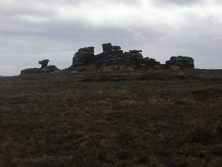
Shallow tor topped by a large cairn, unfortunately, like Chapel Carn Brea, somewhat wrecked by a WWII observation post, but still evident.
|
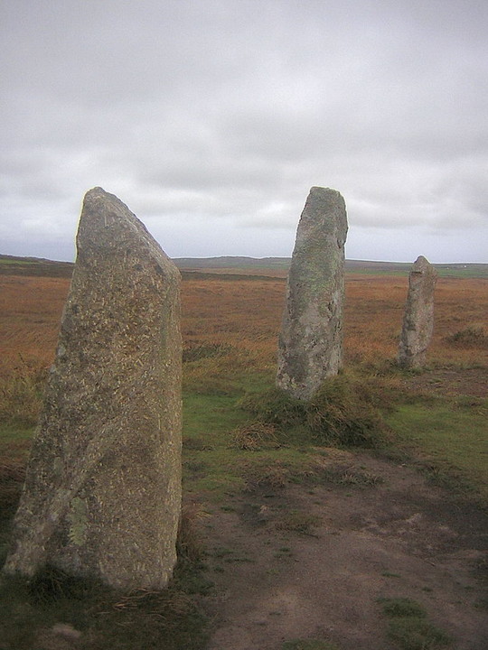
"I should not choose to walk the moor at night; but a neurotic modern would have had nothing to fear on that sunny September morning. Nevertheless, it was with a sensation, not entirely pleasant, of passing from the land of humans to the land of shades that I left the last farm behind and crossed the moor, near the barrow where the famous Tregeseal urn was found, now in the British Museum, in search of the Tregeseal stone circles - two circles seventy-five feet apart. In one, sixty-nine feet in diameter, eight stones are erect and five prostrate; in the other only two are standing, but three more may be found upright in the hedge.
The outlying landmarks or sighting-lines from the eastern Tregeseal circle, probably used by the astronomer priests, are, Sir Norman Lockyer suggests, the Longstone, a monolith ten feet high, on a hillside one and a half miles to the north-east, the apex of Carn Kenidzhek, barrows and holed stones.
He gives the following table as "the meanings of the various alignments":-
Decl. N. Star
Apex of Carn...42d.33'0" Arcturus 2330B.C.
Barrow 800' dist..40d.29'0" Arcturus 1970B.C.
Two Barrows 900' dist. 25d. 20'21" Solstitial?
Holed Stones..23d. 2'20" Solstitial?
Longstone......16d.2'0" May Sun
Stone.............9d. 15'0" Pleiades 1270B.C."
C. Lewis Hind - "Days in Cornwall" (1907)
|
"As far as I know there is only one other stone beside the Men-an-Tol through which one squeezes as a specific, this being the Tolven stone at the back of a farm in the Helford River area, sited on a ridgeway which is crossed by an ancient track to Helston. Here the result being insured being fertility, I feel certain that the prerequisite of nudity also applies. It is a rock pierced by a round hole through which one can just wriggle, the whole performance being plainly a birth symbol."
Ithell Colquhoun - :The Living Stones of Cornwall" (1952)
|
...I visited also the Maen Pol, a huge egg-shaped mass raised on end by a low platform in the middle of another farmyard. Once it was partnered by a monolith still taller: if you follow the muddy track uphill through the farm and beyond to a disused quarry, you can still see where the place where this phallic giant once stood. It used to be the centre of concourse for miles around; even when expedition had replaced pilgrimage and reverence had departed, wonder still remained and a kind of nostalgic affection. But avarice intervened - also, who knows? perhaps a perverse longing for the symbolic castration - and the quarry-face was scooped from under the monolith, which toppled forward over the precipice to be shattered at its base. I looked down with melancholy at the fragments still lying in the stained water of the quarry-tarn; grey heavens were weeping a drizzle as I retraced my steps down the track.
The two great stones were male and female when this place was a centre for that oldest of religions - the cult politely screened under the term 'fertility rites'. But it comes from an age before utilitarian motives were required to justify sex, before puritanism had blighted primitive joy....
Ithell Colquhoun - "The Living Stones of Cornwall' (1952)
|
An interesting trail of possible etymological corruption was noted by the Lamorna resident and surrealist painter Ithell Colqhuhoun in her "Living Stones of Cornwall" (1952)...
"Searching the Boskednan region for another circle called the 'Nine Maidens' as they all are, irrespective of the number of stones composing them, I asked some road-menders where it was.
"Ah, the Ni-Maen, " answered one, and I wondered if these Cornish words had been corrupted..."
|
 
|
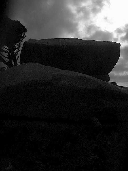
An odd one this...in that I'd been for many years aware of the feature from afar without ever really being able to place it satisfactorily in close up. Men Amber is a granite tor on the most westerly rise of the Carnmenellis granite, and viewed from northerly aspects comprises a readily identifiable outcrop on a long low ridge that also comprises Crowan Beacon, Polcrebo Downs, Longstone Downs (see below) and Prospidnick Hill before the land drops towards the Cober valley and the Lizard. It is the only granite tor visible along this otherwise relatively smooth ridge from a north-westerly direction, and is plainly visible from the North Cliffs and thus sites such as Crane Castle 11km distant.
The tor is very much of the classic 'stacked' formation rather than a crag, and thus is quite possibly the site of a logan stone I have seen reference to in Cornish antiquarian literature as 'being near to Nancegollan'.
It is also at the crossroads of two tracks of arguably great antiquity: firstly a ridgeway slightly bowdlerized by subsequent enclosure running broadly south from Black Rock (adjacent to the cairn and fire summit at Crowan Beacon) along the ridge a modern field's width behind the tor across Longstone Downs; within a couple of hundred yards of Prospidnick Longstone, then just east of the summit of Prospidnick Hill, before becoming a minor road and dropping gradually into the valley of the River Cober to the erstwhile (medieval at least) tidal limit of that river at Helston St. Johns; secondly a mostly intact track which seemingly originated at Tregonning Hill, across NW through Carleen before becoming a hollow way on the direct incline up immediately past Men Amber. East from here a sequence of now unclassified minor roads lead in an almost direct easterly bearing across the Carnmenellis uplands to Porkellis, Longdowns and eventually Mabe Burnthouse above the River Fal.
I need to do some more fieldwork and sight bearings on this one, but am sure it is usefully sightlined with Tregonning Hill, and indeed even as far as the foothills of Penwith looking NW. The shout goes out - calling Mr. Hamhead?!?
|
|
Twelve O'Clock Rock (as it is named on the OS sheets) also somewhat dominates the skyline eastward across St. Ives Bay, and despite its relatively diminutive size, can easily be picked out from the barrow at Godrevy, over 9km away.
|

|

|

|

|
There're the stirrings of a local campaign to get this re-erected according to a recent correspondence in the West Briton newspaper. I for one would like to see it happen, it being the only quoit in the Kerrier area.
|
I watched a re-run of Time Team the other day, and, whilst busy dowsing the fogou at Lamorna, they sent the geophysics team to look for this lost fogou. The site turned up on results!
I assume this was a few years back. As anyone who has ever been in a fogou will know, they're fascinating places, so does anyone know if there's been any follow up on this info?
|
|
I'm pretty confident I've found this one............as corroborated against the 1851 OS map for the area, the stump of what appears to have been a square cut menhir stands in situ at this bleak moorland hill........
|
|
Funny one this....missing from most standing stone literature, but well known to those into Dark Ages stone crosses. It is in fact a menhir which stood on the parish boundary between Gwinear and Gwithian until 1907, when it was moved to its current position in Camborne churchyard. Local historians hold the opinion that it is a prehistoric menhir which was converted into a cross in the 11th or 12th century........this is denoted by the very small and crude crosshead which has been fashioned by tapering the neck of the 6ft plus menhir, then letting it flare out again. The decoration of the crosshead is equally crude, and to all intents and purposes, it still looks like the standing stone it obviously is.OK, it's out of its original position, but it's a "maen" nevertheless, and deserved of recognition............
|
|
.....went to visit on monday evening in the rosy early spring evening light, and how fantastic it looked...........there amongst the birch glades, absolutely perfect. An all too brief sojourn( I had to get to Rowsley for the last Manchester bus of the night ) of some half an hour......but it felt like longer, and certainly was some of the best quality time I've had this year.............they just can't destroy this area, I'd take it over many a bigger site in terms of tranquil setting...........one of the absolute best.
|
|
After being re-erected for a brief period in the mid-20th century, this chamber tomb had collapsed again by 1983. Currently still lying in a sorry state; no plans to re-erect it. Last visited in August 2001, nevertheless impressive and atmospheric.
|
|
Very little remains of this cliff fort which looks like it's gonna completely disappear in the next couple of generations. what would have been a headland defended by a ditch across the narrow neck has now disappeared; a few yards of the defensive ditch, cut into the crumbly cliff rab still 4 feet deep,august 2001.
|
Listen up.allapproaches are very, very muddy..........wellies essential!!
Best place to park if visiting is at the bottom of Hood Hill,SW631387.
Nearest pub:The St.Micheal's Mount Inn in Barripper.not open weekday afternoons though.
|
Overlooked by the very fine Craig Weatherhill guides to Cornwall (CORNOVIA and BELERION), this univallate hillfort round is still worthy of a visit. Marked on the OS explorer map sheet 204 (Redruth&St.Agnes) as a settlement,The Hood presides over the Roseworthy Valley,with sight lines south towards the complex of sites around Black Rock and Carmenellis; and north-west towards Trencrom Hill.
The formation of the fort is preserved by modern field boundaries,and although the interior of the fort is now a perciptibly conical crop field,the ditch still survives on the northern and south eastern circumference.On my last visit in august 2000,the northern ditch was still upwards of 8 feet in depth.As far as i am aware,no excavations have been carried out on this site.
It is accessible by foothpaths from both the Roseworthy and Penponds ends of this section of valley;indeed, the(incredibly muddy)track, Viaduct Lane, which runs along the valley side below,shows evidence of being a "green lane" of great antiquity. It runs inland from the coast at Gwithian to the granite uplands at Carwynnen,and is still a right of way for most of its length, variously as a bridleway and a minor road.
There are other sites along this route;a clapper bridge crosses the stream approx. half a mile inland,which local folklore records as forming part of the "Saints Way" to St.Micheals Mount(SW632387,unmarked); further inland at the Carwynnen village end of the track, lies the currently collapsed chamber tomb, "The Giant's Quoit" (SW650373).
The Hood is certainly worthy of further investigation and recognition.
|
me....stone circles, cheese,music music music, folklore,Kernow,veggie cooking, chatting to folk{get in touch!} ,psychogeography,writing, being out in the weather whatever it may be, hidden corners of the isles...
|
|