Murphy’s Fort
Very curious about this site. At the moment i’m doing a bit a read-up before my Easter trip to Ireland and I came across the name & I thought I made a mistake.
Mullaghmore Townland is on the North-Western slopes below the high Mourne Mountain & very sparsely populated. I have checked the current O.S Map throughly & it’s no longer referred to, which does’nt sound too good, but does’nt mean that it’s gone from the landscape. This definately deserves to be checked out.
The site was excavated by a Dr. J.M. Mogey between 1948 & 1949, and he referred to it as a low mound surrounded by a fosse and outer bank – in total 27.5m in diameter, & a similar structure 7.6m in diameter adjoining on the North-East side.
Additional curious note: A site called the Mullaghmore Cairn in the Dublin Penny Journal, IV (1935-6), which may be the same site, was opened just before 1835. The findings included an ornamented urn (aparently in the possession of the Marquis of Downshire), which contained several calcined bones and a Lachrymatory. This Lachrymatory is a small vessel which contained the ashes of a heart – obviously someone of great importance to the region. But sadly there’s no more information because the vessel turned to dust after being exposed to fresh air.
The question begs...What was the huge significance of this site in South-Down?
|
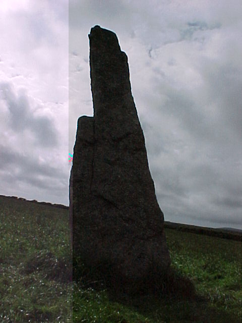
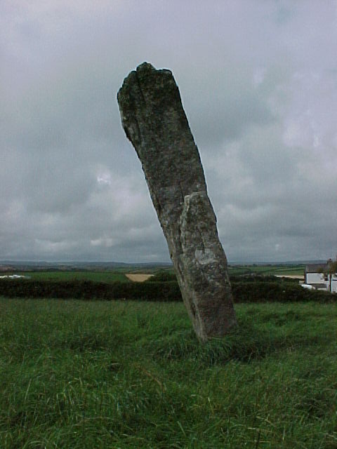
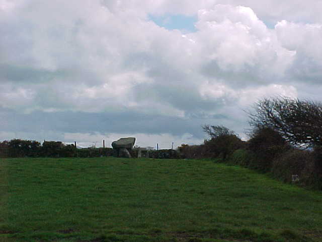
Additional Note: Murlough Stone (J 392343)
Just a short distance away, up the lane which you can see beside Wateresk Dolmen, is a granite standing stone. Two minute walk (max) & it’s on the right-hand-side just past a bunch of buildings.
Another piece in the Murlough puzzle me thinks.
|

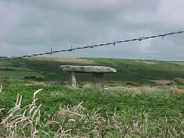
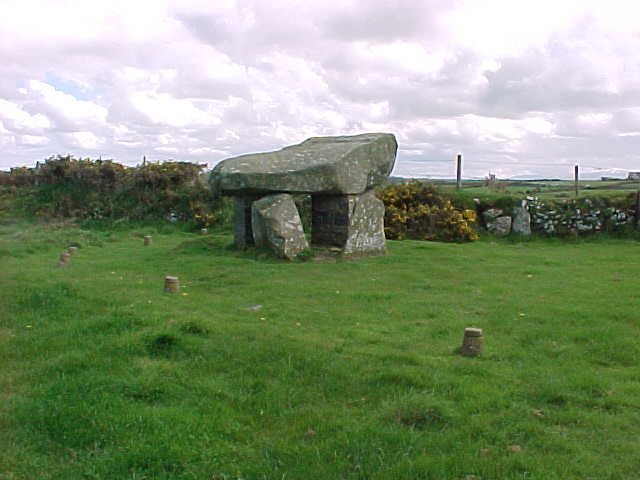
Beautiful granite (as always) Dolmen, sited on the bank of the Carrigs River before it pours into Dundrum Bay.
It's beside the wonderful Murlough National Nature Reserve, looking up to Slieve Donard- the higest Mountain in Ulster, with 2 Cairn sites, & towards Dundrum with it’s Norman fortifications – which was originally the site of a sizeable Celtic hill-top rath commanding the entrance to the bay.
Hugely significant area for spiritual (Slieve Donard most definately played an important role to the locals), economic (seafood rich bay) & military reasons (see previous).
Drive from Newcastle in the direction of Dundrum & stop at the Murlough carpark. Just walk up the Old Road, which turns off to the left, & it’s in the second field on the left hand-side.
|
 
|
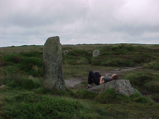
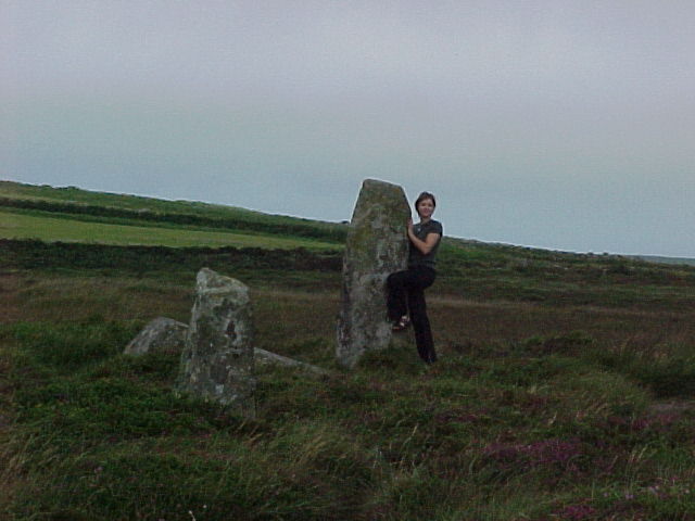
Nine Maidens of Boskednan
Got abit lost in September 2000 trying to find these Ladies.
Tip: once you get to the Ding Dong (Julian’s name) copper mine, just follow the main miners path that goes off to the North-west & they’ll appear out of no-where.
Very peaceful site. Loved it.
|
 
|
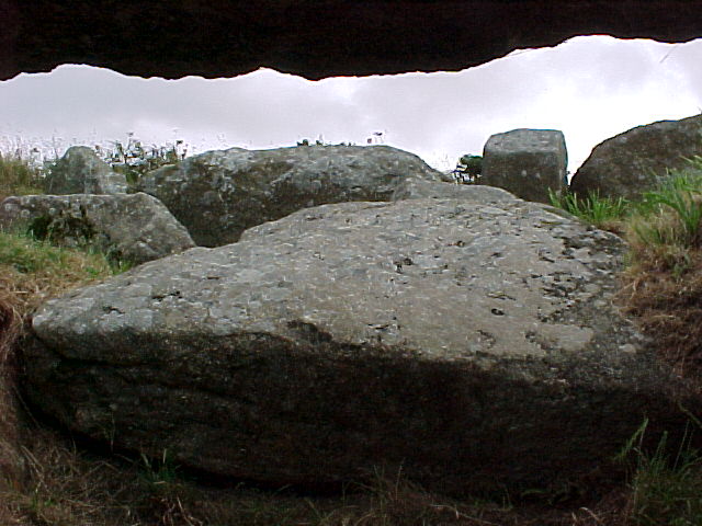
September 2000 – wasn't tooo happy seeing this chambered-cairn, which has been f**ked over by road builders. Still it has faired alot better than similiar examples in Ireland.
Got some weird looks from folks wondering why I was looking around what they thought was a pile of useless stones, considering that The Merry Maidens were sooo nearby. Well, I thought the entrance was impressive & there's still plenty of room to get inside.
|
 
|
September 2000. These guys could give ya a complex. I'll say no more on the subject.
They are short distance over the hill from The Merry Maidens. The fiist thing ya'll see is their HEADS pokin' over the hedges below.
Had a great chat with an old local chap who was full of stories about witches & the Fogou in the nearby village of Boleigh. He knew loads about the sites, deserted villages & what-not in the area.
|

|
The Merry Maidens.
September 2000 ..Yeah!
They certainly do hit ya like a rock as ya drive towards them- don’t they.
The Land’s End Peninsula is blessed with such a concentration of site & a greater proportion are in excellent condition. But these young girlss take the biscuit. When I have children I will bring them there & let them play until they’re done. It’s that kind of place!
|

|
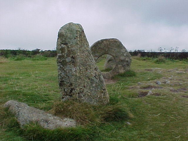
Lanyon Quoit
Another vist from our September 2000 Cornwal trip. It is a bloody cartoon Cromlech...yer right Julian ya know!! Not much more to say about such a famous MEGAlith.
Loads of tourist there at the time...including Herr & soon to be Frau Schlager. Gonna make sure i’am there for early morning next time.
|

|
Became aware of this site for the first time, like alot of folks, when Julian sent out one of his irregular post-cards in the early 90's. The Black & White photo on the other side was amazing.
So I was very excited about finally getting the chance to see this baby in September 2000... but god it's alot smaller than I had thought... wasn't disappointed though.
The Wife hasn't had a baby - yet after the nine-times cermony – but she certainly hasn't had rickets either.
Go... & Viel Spaß! As they say in German.
|
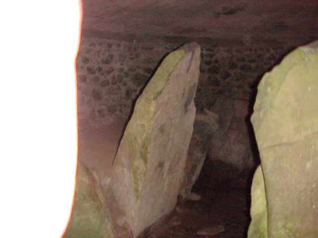
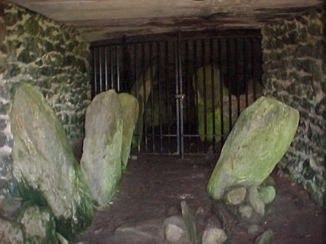
Another visit before Easter 2000. One of the best sited Megalithic tombs I’ve certainly ever seen. Very dramatic to say the least as you look out across the bay and off into the Irish Sea.
What’s with the concrete dome and can ya ever get access through the steel gates? The stones that line the entrance are impressive, but inside is very dark but beautiful temple.
|
   
|
 
|
Ty Newydd
Visited just before Easter 2000. It is a wonderful Dolmen...but I do agree with Julian, it’s repair is simply a disaster.
Has or will anything be done it at least visually improve this site, which is in one of those few undistrubed corner’s of Anglesey not yet effected by development & road-works?
|

|
Knockshee Cairn
Perfect shaped, small round Mountain-top Cairn in Ballintur Upper Townland.
Over 9m in diameter and 1.2m high. It’s been sadly damaged several times over the years by our friends the cross-builders. Last time I looked it had been removed. On one occasion it was burned because it was a Catholic cross...fun..fun...pity about the ancient Cairn.
|
The Long Stone, Moneydorragh Beg Townland.
As Mourne Folk do it all so easily...This Standing Stone or Single Monolith is called the Long Stone & stands atop a small hill in the village of Longstone, near Annalong.
Turn up the Majors Hill road(C315) as ya come into Annalong from Kilkeel, which soon becomes Longstone Rd...then yer there.
This stone (2.5m approx.) is probally a remnant of a larger chambered-grave site which was destroyed. There is a spoken tradition from the area that there was once at least three other stones at the site.
It is however known that the stone was annually white-washed ( lime mixed paint ) & played a part in the ritual of seasonal mountain assemblies, as were several of the other Standing Stones & important natural boulders in the area.
Note: Today they have another tradition in the area as part of the stupid territorial-pissing that goes on in Northern Ireland. Namely: it’s painted often green-white&gold to signify that it’s in a Nationalist area. Protestant areas are of course red-white&blue – see Annalong for examples.
|
Loughananka- Ballynahatten Townland. (Destroyed Site)
A single-chambered grave, which was removed forever, together with everything else in the the square mile area (fields, trees, farmhouses, etc) was cleared to make way for an areadrome between 1941 & 43 – dumped in the sea with other camp rubbish, when the American’s took over in 1942.
It consisted of three massive side-walls and 2 portal pillars, but during the period before the war it was already missing it’s Cap-Stone. It’s location was in the centre of a tiny field, surrounded by a low oval Cairn. Before it’s destruction it was overgrown it bushes & obviously not deemed important. Very sad!
In 1948, a Mr E. E. Evans reported in the Ulster Journal of Archoelogy that nothing remained. He only recovered one small fragment of Bronve-Age pottery & a cremated bone.
Note: Since those dark days, the areadrome was removed bit by bit, but the area surounding is potted with sand-pits old and new. You can see the fragments of the concrete everywhere in Greencastle & Cranfield, as it’s been used as wall building material in an area with few stones.
|
The Giant’s Grave
In Dunnaman Townland, east of Kilkeel along the Newry Road.
This gallery grave lies behind the Curates’s House at Massfort Roman Catholic Church, beside the graveyard oddly enough. Signposted from the main road.
Behind protective fencing, & sadly not often noticed by the locals, but cartainly worth a short visit as the site certainly was originally very impressive. The remaining granite stones are can not be called small. There are four chambers and it’s in total 8m in length, hence the local name for the site, sadly with no surviving facade.
|
The Mother Church of Mourne
I’am mentioning this because it was the centre for the early Church in Mourne, dedicated to St. Colman in the 6th Century, now derelict.
But more importantly, it was built inside a Rath, of which the remains can still be traced and whose curving wall forces Newcastle street to swing round sharply before it drops to the river crossing.
Note: There is an abundance of Raths or Ring-Forts sites in the plain of Mourne. My count is of 56 sites, although many have been partially or completely destroyed. They are known locally as Forths.
|
The Crawtree Stone, Kilkeel
This LITTLE Cromlech, in Kilkeel town, is one of the few in the Kingdom of Mourne to have survived from the hands of the granite stone workers over the years. Not sure as yet how & why it came to be known as The Crawtree Stone, this Smurfer is cute & worth a visit.
Access from Newcastle Street. First out of the town centre, heading of course towards Newcastle, there’s access to a lane on the left just past the mini-roundabout. Just dander up the lane & it’s on the left side in the ditch, or should I say the ditch was built to meet it on both sides....ya’ll know what I mean when ya see it.
The portal single-chambered grave, with it’s entrance pillars, measures about 1.5 x 1.5m. The rounded granite cap-stone is about 2.8m in diameter and rises to a height of 2.5m above ground level.
|
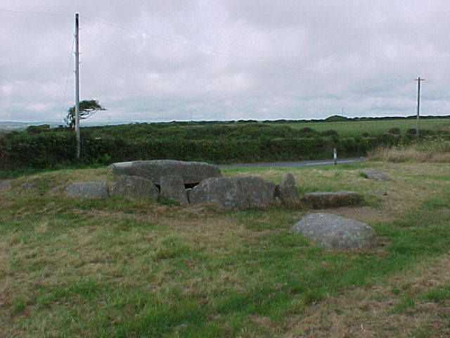
Kilfeaghan Cromlech
Know this big fella for a long time now. Worth the trip even just for the view down onto Millbay, Greencastle & across the border to Carlingford.
It’s a wee bit up Kilfeaghan Road, Signposted from the Killowen Road (A2), second last road on the left before the turn down the Benagh Road (C316) to Cranfield.
The site is off the road to the left at the second group of houses & farm buildings – It’s a State protected site but in farmland ( The Brennan’s), so if ya see anyone just ask & they’ll say no bother, unless there’s a bull in the field!!
It’s a single-chambered grave with a 40 ton granite cap-stone, which measures 3.4 x 2.5 x 1.5m, & appears to be resting almost at ground level. I believe that previous excavations at the site relieved sherds & stone artefacts of the late Bronze Age.
|
Before the Dolmen at Goward Townland was named Pat Kearney’s Big Stone, it was called Finn McCool’s Fingerstone.
Apparently the story goes that the GIANT Finn threw the Cap-Stone playfully from Spelga, which is over the mountains nearly 3 miles away. Finn’s finger’s have left their impression on the cap-stone from when he lifted the beauty.
In the old days there were also tales that Finn thereafter used the chamber beneath as his bed.
Best not to wake him, cause I heard that he was a big lad!!
|
Megaliths ..oh...Megaliths.. The „Cromlech“ or „Dolmen“ at Goward Townland, near Hilltown, needs to be seen to be believed. Situated at 120m above sea level – alongside the straight road between Hilltown & Castlewellen. Clearly signpost & can’t be missed.
Known locally as Pat Kearney’s Big Stone , Pat lived once long ago in a nearby mountain cottage nearby.
The granite cap-stone is simply impressive - the top rises to approx. 4.5m above ground level, and measures 4.0 x 3.1 x 1.5m and covers a single chamber 2.8 x 0.9m, resting in front, not on the stone which covers a single chamber, but a tall upright, which rests in front of the entrance. There are also flanking uprights on both sides.
Sorry got no digital photos at the moment – try sort something for my next visit.
|

|
The Mountains of Mourne, Co. Down – Area Overview
First of my notes on my Homeland (promise).
I've been meaning to get around to contributing for a while, considering that I was born and breed in the area (before settling in Bayern, Deutschland) & have started on the research trail. First an overview of this proud & beautiful Kingdom.
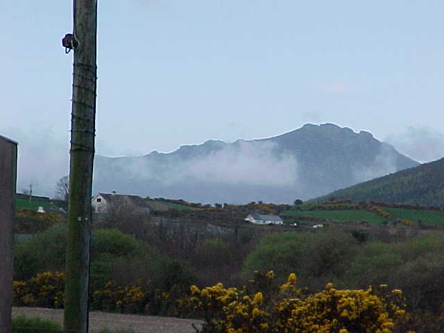
These wild steep-sided granite hills, made famous the world over in a Percey French song (..."where the Mountains of Mourne sweep down to the sea") present an unforgettable aspect. They reach to an average height of about 600m and are largely inaccessable except with a good pair of walking boots, the ring road & one road through the Deers Meadow right in the middle of it all.
Get yerself 1 map... OS of Northern Ireland „Mourne Country – Outdoor Pursuits Map, ISBN 1-873819-07-2. It's got all ya need a easy to pick up in bookshops in Kilkeel, Warrenpoint or Newcastle.
Lots of sites of interest in the area – from Antiquarian (eg. Kilfeaghan Dolmen with it's 40 ton cap-stone) through to the early Church & the Norman's ( Greencastle Castle 1260 CE ) – if ya'll feel like getting/stayin' fit it's got some of the top Hill Walks in Ireland.
So if ya want to explore the Mourne area, i'd recommend that you stay in Carlingford Town, which is just over the County Louth, a day is needed for this place alone. Amazing seafood ....plus 2 castles, Royal Mint, most of the ancient town walls, 2 ancient Churches, lots of character & to top it off the best view of the Mournes....EVER!
Rostrover village is another good option, very charming & bloody great pubs. But don't stay in Newcastle, it's the main tourist centre & very tacky, however the beach & Murlough National Nature Reserve do deserve a visit.
The highest mountain in the Mournes & Ulster is Slieve Donard ( 852 m) – safe & easy climb & on a good day you'll get a view of what looks like the whole of Ireland, West Scotland, Wales, Cumbria, etc.
At one time the mountains were a remote and ungovernable area inhabited by smugglers, now it's just windsweep & very rugged farmers who you won't understand as the old Mourne spek ( as we call it ) is absolutly crazy. Theirs hundreds & thousands of miles of ancient tracks going in all directions through open moorland and upland pastures, which make excellent walking country. The upper sections of the Mounrne Mountains are all characterised by wee fields with dry-stone walls – a custom which remains very strong to this day. Check out the Mourne Wall, it's the largest, 35km long and 2m high, which encloses the water catchment of Silent Valley.
Slán
S
|
Schlager Man hasn't added a profile
|
|