|
|

|
|
The Old Wife's WellSacred Well
|
||||||||||||||||||||||||
|
|
|
Images (click to view fullsize) |
|
|
Miscellaneous |
|
|
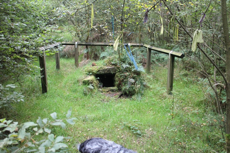
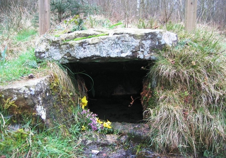
The Old Wife’s Well lies under the dreaded heading ‘Site of Disputed Antiquity’ and of course it is but its location next to a flint Mesolithic site and an old Roman road??? - See below for another explanation - gives it validity, and anyway it is a source of local water for those who have lived or passed this way over the moors, not forgetting the way marking, very probably prehistoric stones, that can be found a couple of miles on along this lonely stretch of moor and also of course the burial cists that can be found under the stone track way. It is difficult to find the well though it is only a few yards from the road but buried inside the forestry trees. There is a forestry track way where you can park on the right just out of the village of Stape, walk along here if you want to see Mauley Cross. To find the well, turn left on the road towards the village and walk a few hundred metres along it, to your left you will see a faint path which will lead to the well. The well has it ‘clouties’ hanging on nearby trees, so does have visitors. Before the vast swathes of the forests were planted around the 1920s on the moors, this would have probably been farm land…… So maybe the spring of water with its unusual inscription may in fact be part of a much earlier prehistoric history….. As the Roman Road/causeway does not appear on TMA here is the explanation for the Wheeldale Linear Monument being interpreted as a Neolithic boundary structure, and mentioned by Fitz.. https://en.wikipedia.org/wiki/Wade%27s_Causeway “here are some objections to the interpretation of the structure as being a road at all, including the fact that several burial cists along the structure's course protrude through its surface by up to 0.4m, highly unusual for a road surface. Since 1997, authorities including English Heritage have accepted the possibility that the structure may not be a road. Archaeological consultant Blaise Vyner suggested in 1997 that the structure may be the collapsed and heavily robbed remains of a Neolithic or Bronze Age boundary wall or dyke. There are other Neolithic remains on the North York Moors, including boundary dikes, although Knight et al. report that the later Neolithic is very poorly represented archaeologically in the North York Moors area] and neolithic use of the moors was likely very limited in extent. Bronze Age presence in the moors, including earthworks, is well represented generally in the archaeology of the area, and therefore is a more plausible origin. Evidence against the identification of the causeway as an early Neolithic structure includes the statement by Elgee in 1912 that the causeway had been identified as cutting across an earlier British earthwork just north of Julian Park, suggesting that it must post-date it. One possibility that could explain several of the anomalies in trying to definitively identify the site is the suggestion by Knight et al. that it was commonly observed practice in the area for dykes to be reused as track ways. To account for the uncertainty regarding the structure's original function, the term "Wheeldale Linear Monument" was introduced in the 2010s to refer to the structure. English Heritage in 2013 stated that the balance of opinion had swung to favour a prehistoric, rather than Roman, origin for the structure. As of 2013, the uncertainty regarding the monument's purpose and origin is reflected by the information board at the end of the Wheeldale section of structure, where it meets the modern road. The original sign, pictured in 1991 states that the structure is a Roman road, whereas new signage installed in 1998 admits that the origin and purpose of the structure are unknown.” |
 Posted by moss
17th September 2016ce |
|
I think we can probably establish this as having a pre-historic origin. In 270 a.d., the Emperor Aurelian declared worship of the sun god, Sol Invictus, an official religion throughout the empire. He dedicated the Sol Invictus Temple in Rome on December 25th., 274, and declared that day Dies Natalis Solis Invicti – the Day of the Birth of the Unconquered Sun. Our midwinter festival has been held on 25th. ever since. If this spring had previously hosted a winter solstice festival, then the Romans patrolling the nearby Wade's Causeway would have referred to it as Fontana Natalis – the 'Birth Spring', or 'Winter Solstice Spring' (the winter solstice being the birth of the year – in the Welsh language, Christmas is Nadolig, in Cornish it's Nadelik, both words derived from Latin natalis - 'birth'). Centuries later, a folk rendition of Latin fontana natalis (perhaps influenced by Norman French 'fontein') was all they could manage. But it's there to this day – Nattie Fonten. Roll on, roll on. |
 Posted by hotaire
8th October 2009ce Edited 8th October 2009ce |
|
From the forum May 2005 the Old Wifes well is lovely and is one of those wells that has a very strong case for having prehistoric origins. The name alone qualifies it as all of the other sites on the NYM that have the Old Wifes name tagged on them have prehistoric associations. Couple this to the fact that the well sits on the edge of a large Mesolithic occupation site which also showed evidence of continued occupation throughout the Neolithic and early Bronze Age where this would have been the only nearby source of water. Add to that the fact that the well is situated beside the route of Wades Causeway the 'Roman road' (aka The Old Wifes Way) which has recently be a source of some speculation as to whether parts of the causeway pre date the roman road, one eminent archaeo has gone so far as to suggest that the section of the causeway that runs across Wheeldale may in fact be a Neolithic linear monument. |
 Posted by fitzcoraldo
29th September 2006ce |
Links |
|
The Smell of water |
Posted by fitzcoraldo 9th June 2014ce |
Pat O'Halloran's WebsiteAnother web page with a picture of the well. |
Posted by fitzcoraldo 22nd October 2004ce Edited 22nd October 2004ce |
Graeme C's excellent Holy Wells sitePictures and a description of The Old Wife's Well from Graeme C. |
Posted by fitzcoraldo 21st October 2004ce |