Previous 50 Previous 50 | Showing 201-237 of 237 posts. Most recent first
Excellent web site. This link is to photo and description of the Cairn, including details of archaelogical finds.
|
This was worth the visit while we were up visiting Kintraw in Feb. 2000.
This is a simple cairn, with capstone still attatched.
We got directions from an eccentric, elderly woman who smelled of whisky and we didn't expect to find it. The Cairn sits above the hamlet of Ardfern which is on the shore of the (sea) Loch Craignish, in a field beside a newish private house. The owners were helpful and we had the company of thier happy little collie dog for the duration of our visit.
Take the Road uphill from the village (towards Craobh) for about a hundred metres, then the private house is up a drive on the right hand side.
|
This is an excellent, informative site. The link is to photo and description of Salachary Stones
|
A friend and I visited this site in Feb. 2000. We drove (probably shouldn't have) half way up the track which leads to this place and used the map to take us across the rough bit of moor land after the track. This is well worth it. These are three very weathered, rough and spooky looking stones, which were aligned in a NNW to SSE line.
Today the alignment is not the aesthetic feature that grabs you - it's the spookily, comic way they now are. The N stone stands upright like a tooth, the middle stone is at an outrageous gravity defying angle and the S stone lies recumbent.
There is a feeling of power here, high up in the moorland.
|
We visited this site in Feb.2000. What a view. Situated high above the head of Loch Craignish on a steep bend in the A816 a short drive north from Kilmartin village.
The views SE over Loch Craignish towards the mountains of Jura and Islay are outstanding.
We had no time to explore the complex Alexander Thom theory as described in the MA. However, this stone seems to have a definite and precise vertical presence which would perhaps support this theory. The journey here is a must, if visiting the Kilmartin area.
|

|
I visited this site with a friend in late 1999 on a cold, damp, very overcast Saturday late afternoon, when we were both hungover. I want to say something about the panoramic nature of this place, but I can't. I want to say something of the inside of the cairn, but we visited out of season and it was locked up.
When I've visited Cairnpapple under better conditions I'll replace this posting.
Sometimes these sites can be so uplifting, and then sometimes so crushing. The mood, the mud, the heavy clouds in the sky, and in my head, all conspired to send us home.
|
Very basic info. but a great photo of the inside of the cairn.
|
|
Cairnpapple is regularly used as a vantage point for skywatchers and is regarded as a UFO hotspot.
|
I'd driven past this place hundreds of times before I knew it existed.
OK, it's got It's own motorway interchange, airport and MacDonalds for our convenience, but something remains of the original feel of this place, I'm sure.
You can see Arthur's seat and castle rock in the city distance.
I visited this site with a friend in August 1999. This site is on low ground, most of the horizon has been taken and it has the feel of a landscaped park. The remaining stones are still impressive.
I've seen worse examples of disrespect and Hully Hill is still well worth the visit.
And I forgot about that big stone at the other side of the roundabout - it's impossible to figure out the reasons for the siting of this stone by just being there now, but it's good to see this stone surviving.
|
Until earlier this year, the area of land immediately surrounding the Airthrey stone was a grassy, gently sloping and undulating field, which was outside the develoed area of the university campus on the edge of a golf course.
Two years ago, the University lodged an application to develop this land into rugby pitches. The original plans did not even refer to the stone.
After protests, the plans were altered and the stone was to be "protected" inside a tacky, fenced off, platformed viewing area. Thankfully the platform didn't happen.
What did happen though was that, because of the sensitive nature of the site, the local council referred the plans to the Scottish Executive and then after a few months, and without any public announcement, the work to flatten the land started earlier this year. Thousands of tons of earth and rock were spirit-levelled in the land around the stone, irrepairably taking this monument's immediate landscape from it. Now it stands, fenced off between the ironed flat pitches on one side and a golf course on the other.
Stirling University has both a history and an environmental science dept.!!?
What do you do when your spirit has been levelled by the hard, cold, yellow bastards (and I dont mean the JCB's)?
You do what the Airthrey stone does - keep standing!
And it does, all of 15ft high and 9 ft. wide. It still has the Abbey Craig to the south and the Ochils on the north east for support - and the sun and the moon and the stars - and us.
|
It is believed by some historians that the Airthrey stone played a part in the birth of the Scottish nation around 860AD. Kenneth MacAlpin is believed to have gathered his west coast, celtic army at the stone, before defeating a north eastern Pictish army. This was the most important in a series of battles, in a power struggle which ended when MacAlpin was crowned the first king of the new, united Scotland.
Other stones in the area were reported to be used as standard, or gathering points before important battles at different times. (The Randolphfield stones during the battle of Bannockburn in 1314 and the Sherriffmuir stone row, before Wallace's Battle of Stirling Bridge in 1297 and the Jacobite Battle of Sherriffmuir in 1715).
|
This broad 15 foot stone has a presence and a strength in the area of low lying land between the Ochil Hills to the north, and the Abbey Craig to the South.
It sits in the grounds of the University of Stirling (in the old Airthrey Castle estate-the Castle is just 300m to the north), at the side of some newly seeded rugby pitches, with a golf course nearby.
The stone's existence was threatened recently (see misc. section) but survives now, still strong, between the golfers on it's immediate west and the rugger bugger's touchlines on the east.
The Abbey Craig, 500m to the south and Dumyat Hill (Ochils) 2.5km to the north east, seem to be important to the siting of this stone.
|
  
|

|
I took a break from a long drive home, to visit this site exactly 2 years ago in November 1999.
As I drove up to the stones, the vastness of this site hit me with a delicious excitement.
I was on a tight schedule unfortunately so I could only stay less than half an hour.
I walked around and around and in the circle, sitting on and touching the stones. I felt this place had an incredible spirituality and I so wanted to stay. You could spend the whole day here.
And after reading in the Modern Antiquarian about the attempts to destroy this place, being there, with the track going through the giant circle, the nearby farm, the sky, the earth and those trees adding thier own twist, this place does so much more than just survive.
Also a little thing which I almost forgot - there was a fine carpet of millions of these little spider web things covering the grass over the whole site and when I was facing the setting sun, this view, with the stones all around, was incredible.
|
  
|
An interesting and very informative site which seems to have been set up by the Fortingall Hotel.
|
This is the most enchanted place.
The yew tree in the village kirkyard is at least five thousand years old. It is claimed that this magic and ancient thing is the oldest living thing on our planet outside of North America.
Pontious Pilate was reported to have been born and brought up here. the legend says that Pilate was the child of a local woman, and a Roman dignitary. The yew tree would have been at least 3000 years old when Pilate was born. Did he climb it as a boy?
By the time the influence of Jesus' crucifixion and the subsequent religion of Christianity returned to this village, and the sacred site of the tree was claimed by the Roman church, the yew was then about 4000 years old.
The location of this place adds to the magic. The village sits at the bottom of the longest glaciated U-shaped river valley in these isles, Glen Lyon, which has numberous stones and cup and ring marked rocks. I've only seen this Glen on a map, and I intend to visit it. The mountainscape is also stunning.
|
We (my partner , my 2 boys and myself) visited Fortingall on the recommendation of one of the guides at the Kenmore Crannog Centre last August 2000.
We parked and set up the stove in the car park next to the hotel and cooked lunch (today, (19/11/01), we had rice cakes and baked beans with curry powder - not a meal we have a lot - and Al. remarked that this was the same lunch we had at Fortingall - I'd only posted this message yesterday and I replied that I should tell you all what we had for lunch at Fortingall - Al. told me not to be so stupid).
After lunch we visited the kirk and the yew tree and then took a walk to the 3 little stone circles down the road.
What a beautiful little site!
This village really did leave an impression on us all (well the adults anyway).
|
   
|
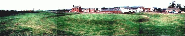
I visited this site (and Balbirnie) with a friend, last autumn at dusk, just as the lamp-posts which surround the henge were switched on. The houses have taken most of the horizon and most of the everything from this site - the street has been built so close to the edge of the henge.
Defying all are the remaining stones.
The complex and very ancient nature of this site is now hard to appreciate as is any kind of feeling.
Glenrothes has not been good to it's ancient heritage and what happened here should make us vigilant.
|
Important in all the sites in this web site is the landscape that these monuments are set in. The particular points in the land where these sites are, were chosen, I'm sure, and not by chance. The whole monument was dismantled, moved, and reconstructed at the present site in 1970, (stones, burial cists and all), to fit in with the neat planning of the new-town road network. As if out of conscience for what happened to this site (and Balfarg), the planners have built a standing stone theme roundabout nearby.
I find this all a bit strange, and I didn't have a good feeling after visiting this place.
|
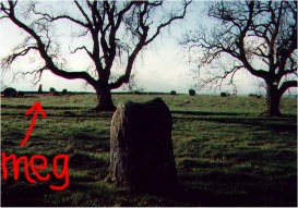
My partner and I visited this site in summer 1993 - this was the first stone circle we both had been to.
We thought there might be ettiquette at these places - like hushed reverence or something - when we got there, there was an older couple lying down, snogging on the grass at the side of the circle. We looked about for a wee while then went back to the car and had our breakfast. We went back and the couple were away and we clambered about the stones, posing and taking photographs (I'll try and upload them soon - I like these photos cos I've got a full head of hair and a couple of buttocks less fat). We stayed there all morning - it was a fresh bright morning - I'll never forget the impression this place left on me.
We left and visited Culloden battlefield, later the same day (there was a mournful and haunting atmosphere here). The place was almost lost in a thick pea soup fog - couldn't have been more different from East Aquhorthies.
|
3 years ago (in 1998) I lived 2.5 miles NW of this site in Fallin village.
At this time, I had a vivid dream that I was on a search for something, walking along a long straight farm track towards some rocky hillocks and a quarry. In this dream, I knew that this place was somewhere in between Stirling and Falkirk in an area of land which I hadn't been to before, and that I was walking away from my home roughly south bound.
In another dream, which I had at around the same time, I flew (or visually travelled) from my home, across the flat carselands towards Airth village, and then through a wood, where there seemed to be something special. It didn't matter that I couldn't see it - it felt youthful-alive-a real treasure. I woke up and I knew where this was, roughly, although I hadn't been there before.
I had these dreams at a time when I was becoming more aware of my, and our ancient pasts.
The first time I knew of the cup and ring markings at Castleton, was last year, when I noticed cup and ring markings were indicated on the new edition of the landranger OS map. (These markings were never mentioned on any of the previous editions of the map and I was a bit spooked).
I searched on the internet and found mention of the markings at the RCAHMS website and became a bit obsessed.
I eventually visited Castleton last October (2000), and the shape / form of the rocks, the old quarry, the long straight farmtrack SE of Cowie and the woods just north of Hillhead farm nearby, all felt like they were in the right places in relation to the dreams.
To get to the site, I walked from the village of Plean to Carnock House and through the woods at Hillhead farm. Going home, I walked along a straight farmtrack to Cowie. I'd never been to this whole area before.
The next time I go, I intend to walk from Cowie along the straight track going south east from the village - as this seems to be the way I walked in the first dream.
|
Last year , I saw these cup and ring marks mentioned in the new landranger map (it wasn't there in any older maps I had ever seen).
I became obsessed (see miscellaneous) and visited the site in October 2000, starting my walk from the village of Plean.
There are a few rocky outcrops in the area, some of which are heavily overgrown with gorse, and an old quarry.
I found some very weathered cup markings and a cup and ring mark on the edge of one of the outcrops and another group of markings in the middle of the same outcrop. It was getting dark and I walked to the village of Cowie and got the bus home. I hadn't eaten all day and I was exhausted
This summer I avoided the site because of the foot and mouth threat.
I intend to go back to this place to take photos and spend more time looking about.
|
These stones are supposed to have played a strategic role on the first day of the battle of Bannockburn in 1314. A Scottish nobleman, Lord Randolph gathered a company of spearmen at the stones, in order to block a move by English cavalry who were trying to reach Stirling Castle from the South.
Other standing stones in the area have been reported to have been used as landmarks before battles. A stone row 5 miles away in Sheriffmuir was used as a gathering point before Wallace's Battle of Stirling Bridge in 1297 and the Jacobite Battle of Sherriffmuir in 1715. A 15ft standing stone in the grounds of Stirling University is claimed to have been used by the western Gaelic army of Scotland's first king, Kenneth Macalpin, before the battle with the North Eastern Picts which resulted in the formation of Scotland.
|
I didn't know these stones existed until about 3 years ago, when I saw them marked on a victorian map. It took me to find out where exactly they were and then when I found them I was uplifted - these stones are less than a mile from my home.
I pass them several times a week now so it's hard to write about them.
The stones are about 50m apart, sitting on the grass lawn at the front of the Central Scotland Police HQ where they train the alsations. (although naked shamanism is not advised, the site is fully accessible).
Despite being in the middle of the office zone of Stirling, with a main road closeby, there is still an air of peace here.
The stones are sat on a large raised flat shelf area, close to the raised ice age beach, above the Carse of Stirling. When the stones were erected, it is likely that the Carse was boggy, with the stones sat above and to the SW of the Carse, on dry, prime agricultural land. There would have been important views of the crag and tail formations of the Abbey Craig to the NE (Wallace Monument), the castle rock to the N (where the castle and old part of town now sit) and also sweeping views of the Ochil Hills to the N and E.
Much of the visible horizon is now taken up with the surrounding office buildings.
Despite this, Randolphfield is still a special place.
Check out the modern tributes to this pair at the other side of the main road in the front garden of 1 Newhouse, and at the pedestrian precinct in the town centre at the bottom of King Street half a mile to the north.
|
Had a picnic on our tartan rug here last summer, with the family. We were camping at Kenmore and on the only day of that week that the sun came out, we made the point of coming here for lunch and to dry out among these stones.
This is a special and complex place. Many trees on the other side of the road -cant see the confluence of the 2 great rivers a few hundred yards north and down the hill. We had a great lunch there though and the place has an alive feeling.
Also worth looking for are the 2 stones,(map ref. 793 467) less than a km to the south just inside the grounds of Taymouth Castle not far from the estate road.
|
I visited the Ballochmyle walls last summer with my partner and our two boys.
We didn't have much clue as to where we were going - all we had was a road atlas and the directions in the Modern Antiquarian.
This part of the Ayr valley is truly enchanted. The valley is narrow, deep and heavily wooded - these woods are ancient. The surrounding land outside and above the valley is rolling green pastureland, so when you descend into the valley you feel like this is just a different world.
Our search for the walls turned into a true quest lasting an hour and a half of me scrambling around, losing, finding and losing the family. While searching, I was down by the river - it's deep and dark and goes slow beneath great red sandstone cliffs on either side with these little red beaches at your feet, and the green canopies high above and all around. There's also a huge red stone Victorian viaduct which straddles the valley nearby.
What a feeling when we found the walls!
They consist of 2 vertical cliff faces with a variety of cup / ring / animal and phallic symbols carved into the soft and brittle sandstone.
The cliffs were only rediscovered less than 20 years ago, so their current exposure leaves the carvings vulnerable to erosion - before rediscovery they were covered in thick vegetation.
The carvings are unusual, in that they are on vertical, not horizontal sheets, but quirks of a wider culture are understandable down there in that valley.
Also not usual in Scotland(?) is the animal carvings - the only other possible prehistoric animal carving I've seen in Scotland was at Dunaad.
You could spend all day here - the surroundings were warm and serene that day but the walls had a dark red drama that took our breath away. Our gameboy / pokemon obsessed boys were held in wonder and that was great to see.
It's a bugger to find though and I can't shed much light on how we found it other than to take a better map than we had.
-August 2002-
Came back here with Norie of the pictures.
I dont know if it's my imagination but the walls looked to have deteriorated a bit.
And somebody has been at the carvings with a mix of charcoal, chalk and wax crayon.
This kind of thing is bad enough on horizontal sheets of hard rock but to arse about with these walls is plain vandalism as the rock is crumbly sandstone and the rain wont get a chance to wash the crayon etc. away as these are vertical cliffs.
It still remains a very special place but I felt pretty pissed off after this visit.
|
Previous 50 | Showing 201-237 of 237 posts. Most recent first
winterjc hasn't added a profile
|
|