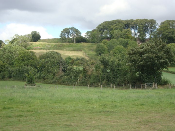
The Devils Ditch as it runs up through Tidworth area
Image credit: Chance - Aug 2011

The Devils Ditch as it runs up through Tidworth area

The Devils Ditch as it runs up through Tidworth area

The Devils Ditch as it runs up through Tidworth area


Although most of the barrows survive, some have suffered damage from tree roots and others have been dug into by the wildlife.

The barrows are now protected by a rabbit proof fence and “no trenching” signs.
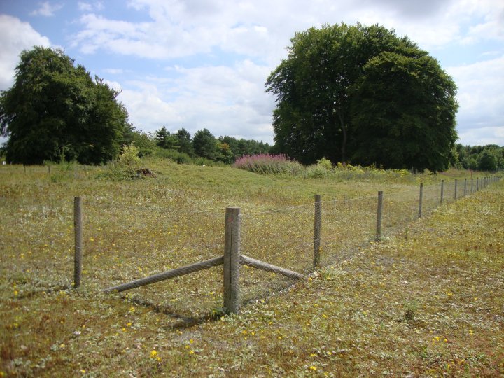
Overall view looking down the line of barrows
Details of Barrow cemetery on Pastscape
A group of seven bowl barrows arranged as a linear group of five barrows orientated north-south with two outliers to the east. The barrows form the Seven Barrows bowl barrow cemetery.
Group centred SU 2186 4870 Seven Barrows (Tumuli)
[O.E.] [A,B,C,D,E,F,G,H and J]. (1)
A group of nine barrows is marked on the O.S. 6”; known as Seven Barrows. A further bowl barrow [K] of small dimensions was found by the author [K – SU 2189 4864]. (2)
Investigations subsequent to Grinsell’s have showed at least three have almost been completely destroyed by military action, mainly tank practice tracks. five others have been badly damaged by military trenches. (3-5)
--------------------------------------------------------------------------------
SOURCE TEXT
--------------------------------------------------------------------------------
( 1) Ordnance Survey Map (Scale / Date) OS 6” 1925
( 2) General reference – Proceedings of the Hampshire Field Club 14 1938-40 pp28, 29, 347
( 3) Field Investigators Comments – F1 WW 07-JAN-56
( 4) Field Investigators Comments – F2 FGA 25-JAN-67
( 5) Field Investigators Comments – F3 JGB 23-SEP-82
( 6) General reference – English Heritage Schedule Entry 03/01/1997
Visited Early Aug 2011
A pair of undisturbed and so, undated bowl barrows. These barrows sit beside the old coach road that once linked Salisbury with Marlborough. This section of the coach road may well be prehistoric as it runs between numerous ancient sites. The barrows are now protected by a border of stakes as is the nearby milestone. The barrows are listed as a Scheduled Monument number WI10181 and are listed on the Wiltshire SMR as SU24NW600 and SU24NW601. The milestone is also listed as SU24NW527.
Although these barrows are hardly impressive and nothing really worth seeing, they are an important landmark when travelling on this area of the plain, especially when calculating your position with the O.S. map. The coach road is also a dedicated public byway and regardless of other military traffic running around the area, should always be open to dedicated antiquarians.

The barrows are just visable above the surrounding vegitation.

Sidbury hill from the old coach road and the barrows
Details of Barrow cemetery on Pastscape
A barrow cemetery comprising twelve barrows, nine of which are enclosed by The Coniger (SU 04 SE 83) a Medieval enclosure. The cemetery includes examples of bowl, disc, saucer and pond barrows which were excavated by Colt Hoare in 1809. The excavations located cremations in all but two of the barrows. The cremations were often placed within an inverted urn, two of which appeared to be wrapped in cloth, and were accompanied by grave goods which included a dagger and personal ornaments. Some of the finds are in Devizes Museum. One of the barrows, (SU 04 SE 78) also contained a Saxon inhumation with a knife. The barrows were surveyed by RCHME field staff in 1992 and were mapped at 1:10,000 scale as part of the RCHME: Salisbury Plain Training Area NMP project , and subsequently revised for the English Heritage Stonehenge WHS Mapping project..
SMR(SU 077420) Tumuli (NR). (1)
Barrows resurveyed at 1:2500 (2)
A group of 12 barrows, nine of which are enclosed by The Coniger (SU 04 SE 83) a Medieval enclosure. The cemetery includes examples of bowl, disc, saucer and pond barrows (3-4). Excavations by Colt Hoare in 1809 located cremations in all but two of the barrows. The cremations were often placed within an inverted urn, two of which appeared to be wrapped in cloth. Grave goods included a dagger, personal ornaments including amber and faience beads, shale rings and `incense cups’ with twisted cord decoration (5). Some of the finds are in Devizes Museum (6). One of the barrows, (SU 04 SE 78) also contained an Early Medieval inhumation with a knife.
The barrows and rabbit warren were surveyed by RCHME field staff as part of a project focusing on the earthworks of South Wiltshire. Full details are contained in the archive report. (7)
Scheduled. (8)
The earthwork remains of the Bronze Age barrow cemetery contained within a polygonal Medieval embanked enclosure which were decscribed by the previous authorities were seen centred at SU 0770 4200 and mapped from aerial photographs. The majority of the barrows appear to be in reasonably good condition, some showing evidence of earlier excavations. The two barrows recorded by the SMR as 650 and 652 both lie outside the medieval enclosure. The barrows were recorded as follows:
-NMR SU04SE 71 (SMR 644) at SU 0765 4204, a bowl barrow with diameter of 22m.
-NMR SU04SE 72 (SMR 645) at SU 0765 4200, a bowl barrow with diameter of 24m.
-NMR SU04SE 73 (SMR 646) at SU 0766 4199, 2 confluent bowl barrows.
-NMR SU04SE 74 (SMR 647) at SU 0766 4197, a bowl barrow.
-NMR SU04SE 75 (SMR 648) at SU 0771 4201, a bowl barrow.
-NMR SU04SE 76 (SMR 649) at SU 0771 4197, a bowl barrow with diameter of 26m.
-NMR SU04SE 77 (SMR 650) at SU 0778 4195, a bowl barrow with diameter of 26m.
-NMR SU04SE 78 (SMR 651) at SU 0765 4208, a disc barrow, diameter c. 35m.
-NMR SU04SE 79 (SMR 652) at SU 0775 4197, a disc barrow, diameter c. 30m.
-NMR SU04SE 81 (SMR 654) at SU 0768 4199, a disc barrow, diameter c. 40m.
-NMR SU04SE 82 (SMR 655) at SU 0767 4195, a pond barrow, diameter 14m.
-(SMR 823) at SU 0769 4197, a mound with a diameter of 10m.
These features were mapped at 1:10,000 scale as part of the RCHME: Salisbury Plain Training Area NMP project , and subsequently revised for the English Heritage Stonehenge WHS Mapping Project. (9-11)
--------------------------------------------------------------------------------
SOURCE TEXT
--------------------------------------------------------------------------------
( 1) Ordnance Survey Map (Scale / Date) OS 25” 1901
( 2) Field Investigators Comments F1 PAS 12-Dec-1974
( 3) The Wiltshire archaeological and natural history magazine (E H Goddard) 38, 1913-14 Page(s)368-69
( 4) edited by R B Pugh and Elizabeth Crittall 1957 A history of Wiltshire: volume 1, part 1 The Victoria history of the counties of England Page(s)203, 206, 221, 224
( 5) by Sir Richard Colt Hoare; introduction by Jack Simmons and D D A Simpson 1975 The ancient history of Wiltshire Page(s)113-15
( 6) General reference – Neolithic and Bronze Age Antiquities Devizes Museum 1964 pp 59, 61, 65
( 7) Field Investigators Comments RCHME Field Investigation 20-MAR-1992 (CR Lewis)
( 8) General reference – English Heritage Schedule Entry 13/11/1996
( 9) General reference – RAF CPE/UK/1821 2284-5 04-NOV-1946
(10) General reference – RAF 106G/UK/915 321 11-NOV-1945
(11) General reference – NMR SU 0742/14-15 25-JUL-1980
Details of Barrow cemetery on Pastscape
Eleven Bronze Age bowl barrows of the Winterbourne Stoke East barrow cemetery surrounded by an oval Medieval or later earthwork enclosure. This barrow group is situated on the western end of Fore Down. All the barrows were partly excavated in the 19th century. All barrows survive as earthworks. These features were mapped at 1:10,000 scale as part of the RCHME: Salisbury Plain Training Area NMP project , and subsequently revised for the English Heritage Stonehenge WHS Mapping Project.
SU 0818 4239 (SMR No.656) with a diameter of c.27m (Centred SU 082423) Tumuli (NR) (1)
The “Winterbourne Stoke (East)” group of bowl barrows all within a Md or later banked enclosure, area 7 acres. All listed by Grinsell and all the barrows were dug by Hoare. (2-3)
All eleven barrows visible within enclosure. (4)
A group of eleven bowl barrows (Nos 55a – 60c) enclosed by a later bank and ditch situated on the SW end of Fore Down.
Re-surveyed at 1:2500. (5)
The earthwork remains of eleven Bronze Age bowl barrows of the Winterbourne Stoke East barrow cemetery described by the previous authorities were seen centred at SU 0825 4233. The group is surrounded by an oval Medieval or later earthwork enclosure 155m x 225m.
These features were mapped at 1:10,000 scale as part of the RCHME: Salisbury Plain Training Area NMP project , and subsequently revised for the English Heritage Stonehenge WHS Mapping Project.
The barrows were individually recorded as follows:
-SU 0818 4239, NMR No.115 (SMR No.656) with a diameter of c.27m
-SU 0825 4233, NMR No.112 (SMR No.657) with a diameter of 38m
-SU 0827 4240, NMR No.120 (SMR No.658) with a diameter of 16m
-SU 0823 4236, NMR No.110 (SMR No.659) with a diameter of 20m
-SU 0834 4232, NMR No.117 (SMR No.660) with a diameter of 18m
-SU 0824 4228, NMR No.118 (SMR No.661) with a diameter of 12m
-SU 0830 4234 , NMR No.116 (SMR No.662) with a diameter of 10m
-SU 0829 4234 , NMR No.113 (SMR No.663) with a diameter of 10m
-SU 0828 4235, NMR No.114 (SMR No.664) with a diameter of 16m
-SU 0831 4233 , NMR No.111 (SMR No.665) with a diameter of 14m
-SU 0817 4233 , NMR No.119 (SMR No.666) with a diameter of 14m
(7-8)
--------------------------------------------------------------------------------
SOURCE TEXT
--------------------------------------------------------------------------------
( 1) Ordnance Survey Map (Scale / Date) OS 6” 1961
( 2) General reference – Victoria County History Wiltshire 1 1957 pp202-3
( 3) General reference – Colt Hoare R 1812 History of Ancient South Wiltshire 1812 pp115-6
( 4) Aerial photograph – AP (Crawford colln 6444 undtd)
( 5) Field Investigators Comments – F1 PAS 11-DEC-74
( 6) General reference – English Heritage Schedule Entry 30/08/1996
( 7) General reference – RAF 82/1225 0105 13-SEP-1955
( 8) General reference – NMR SU 0842/36 (15269/15) 19-APR-1995
Details of Long Barrow on Pastscape
The earthwork remains of a long barrow orientated east-west. A 36m length of mound survives as a visible earthwork which varies in height from 1.5m to c.1m. The remainder of the mound is visible as a slight rise in the field surface. This long barrow was mapped at 1:10,000 scale as part of the RCHME: Salisbury Plain Training Area NMP project, and subsequently revised for the English Heritage Stonehenge WHS Mapping Project.
(SU 09174279) Long Barrow (NR) (1)
Grinsell’s Winterbourne Stoke 53. Oriented E-W, length 104ft, width 64ft, height 3 1/2ft. Side ditches vague, and mound badly damaged. (2)
Hoare’s No 3, which he opened with Cunnington. ? Primary cremation mixed with chalky marl, covered with a large pile of flints also mixed with chalky marl, found towards E end. Further E two cists containing large quantity of wood ashes. “Platform cremation”? (3)
A mutilated grass covered long barrow situated on a downland spur. Oriented E-W, it measures 36.0m long by 18.0m wide with the W end 1.7m high sloping (unusually) to 1.2m at the E end. All traces of the ditches noted by Grinsell have now been
destroyed. Re-surveyed at 1:2500. (4)
Originally recorded as Winterbourne Stoke 53 by Goddard (5)
(SU 092428) Winterbourne Stoke 53 (Kinnes, SU 66) Longbarrow orientated east, with Kinnes Type A ditches. Contained crematorium deposit at east end with burnt chalk and calcined bones, covered by a flint cairn. Also two deep pits with charcoal fills. (6)
Surveyed by RCHM. (7)
The earthwork remains of the long barrow described by the previous authorities was seen centred at SU 0916 4279 and was mapped at 1:10,000 scale as part of the RCHME: Salisbury Plain Training Area NMP project. It was subsequently revised at 1:2500 scale for the English Heritage Stonehenge WHS Mapping Project. The barrow lies within a later Prehistoric or Roman field system recorded as SU04SE 16. (8)
--------------------------------------------------------------------------------
SOURCE TEXT
--------------------------------------------------------------------------------
( 1) Ordnance Survey Map (Scale / Date) OS 6” 1961
( 2) General reference – Victoria County History: Wiltshire 1 1957 p146 (L V Grinsell)
( 3) General reference – Hist of Anc S Wilts 1 1812 117 plan (R Colt Hoare)
( 4) Field Investigators Comments – F1 PAS 21-NOV-74
( 5) General reference – Wiltshire Archaeological Magazine 38, 1913-14, p367, p407 (E.H Goddard)
( 6) General reference – British Museum Occasional Paper 52, 1992, 11, 29 (I. Kinnes)
( 7) General reference – RCHME: South Wilts Project
( 8) General reference -
Details of Pond Barrow on Pastscape
A Bronze Age pond barrow, the northern most barrow in a group of three round barrows situated on Ballard Down. The barrow survives as an earthwork comprising a circular depression 10 metres in diameter and 0.5 metres deep, surrounded by an outer bank one metre wide and 0.2 metres high. In 1967 finds including pottery, burnt bone and shale were recovered from the area of the outer bank by E.E Harrison. The finds are held in the Dorset Museum.
(Centred SZ 039813) Tumuli (NR) (three shown) (1)
SZ 03988132. A pond barrow with enclosed area of 33 feet in diameter by 2 1/2 feet deep and outer bank 12 feet wide x 1 foot high. Excavated by J.H. Austen in 1857 but with no result. (2-5)
Grass covered pond barrow consisting of a circular hollow 11.5 metres in diameter and 1.2 metres deep. (6)
Pond barrow, recently ploughed. Pieces of pottery, burnt bone and shale were picked up from the surface in the southeast sector of the barrow by E.E. Harrison in 1967. From their position they appeared to have come from the bank of the barrrow. (7)
SZ 03988133. A circular depression, 33 feet across and 3 feet deep with an irregular bank is more likely to be a pond than a pond barrow (but see Authority 7). (8)
No change to Authority 8 but National Grid Reference should read – SZ 03988132; Barrow on grassland, in good condition, 117m OD. Surveyed at 1:2500. (9)
One of a group of three round barrows situated on Ballard Down. The pond barrow is the northern most barrow of the three and survives as a circular depression 10 metres in diameter and 0.5 metres deep, surrounded by an outer bank one metre wide and 0.2 metres high. In 1967 finds including pottery, burnt bone and shale were recovered from the area of the outer bank by E.E Harrison. The finds are held in the Dorset Museum. (10)
--------------------------------------------------------------------------------
SOURCE TEXT
--------------------------------------------------------------------------------
( 1) Ordnance Survey Map (Scale / Date) OS 6” Prov Edition
( 2) General reference – Austen J.H. Purbeck Paper, 161-163
( 3) by Charles Warne 1866 The Celtic tumuli of Dorset : an account of personal and other researches in the sepulchral aounds of the Durotriges Nos 94-95b
( 4) General reference – Crana Britannica. 1865, 2 p45
( 5) by L V Grinsell 1959 Dorset barrows – Page(s)133, 172
( 6) Field Investigators Comments – F1 JR 01-SEP-1952
( 7) Proceedings of the Dorset Natural History and Archaeological Society – E E Harrison and J B Calkin 89 (1967) Page(s)140-41
( 8) by Royal Commission on Historical Monuments (England) 1970 Inventory of historical monuments in the county of Dorset: Vol 2, South-East (in 3 parts) – Nos 89-90 Page(s)453
( 9) Field Investigators Comments – F2 CFW 16-AUG-1985
( 10) Scheduled Monument Notification – 25-JUN-2001
Details of barrow on Pastscape
A large Bronze Age bowl barrow on Coneybury Hill, listed by Grinsell as Amesbury 23. According to Stukeley, excavation in 1722 recovered a “very large brass weapon of twenty pounds weight, like a pole-axe”. Grinsell suggested that this might have been a large halberd similar to one found at Leubingen, Germany. An excavation in the mid-19th century by Thurnam was apparently unproductive. A large whetstone in Salisbury Museum is labelled “King Barrow”, presumably Amesbury 23. A bronze dagger and two shale cups within the same museum are also suggested to come from the same barrow. A bronze flanged axe is less certainly associated. The barrow is extant as an earthwork mound 3.9 metres high and around 30 metres in diameter. Scheduled.
(SU 13554137) Tumulus (AT). (1)
Amesbury 23. “King Barrow”, a bowl barrow 99 ft in diameter and 10 ft high. According to Stukeley, ‘a very large brass weapon of twenty pounds weight, like a pole-axe’ was found in it in 1722,? an all bronze halberd, as from Leubingen. A whetstone about 12 inches long from the barrow is in Salisbury Museum. (2)
Amesbury 23. A bowl barrow 3.9m high; slightly oval probably because of ploughing. Published 1:2500 survey revised. (3)
Originally recorded as Amesbury 23 by Goddard. (4) The finds, a flanged axe, hone, dagger and two shale cups are thought to have come from this barrow. They were part of the Job Edwards Collection presented to Salisbury Museum in 1898. (5)
SU 13544139. King Barrow scheduling amended. (7)
The barrow is visible as an earthwork on aerial photographs, and has been mapped by both RCHME’s Salisbury Plain Training area NMP and EH’s Stonehenge WHS Mapping Project. (8-9)
--------------------------------------------------------------------------------
SOURCE TEXT
--------------------------------------------------------------------------------
( 1) Ordnance Survey Map (Scale / Date) OS 6” 1961
( 2) edited by R B Pugh and Elizabeth Crittall 1957 A history of Wiltshire: volume 1, part 1 The Victoria history of the counties of England LV Grinsell: Archaeological Gazetteer Page(s)150
(4) The Wiltshire archaeological and natural history magazine EH Goddard: A list of prehistoric, Roman and pagan Saxon antiquities in the county of Wiltshire... 38, 1913-14 Page(s)167
( 3) Field Investigators Comments F1 ANK 21-DEC-70
( 5) by C N Moore and M J Rowlands 1972 Bronze Age metalwork in Salisbury Museum Salisbury and South Wiltshire Museum occasional publications Page(s)43-4
( 6) by Frances Blore, et al. 1995 Archaeological assessment of the Stonehenge World Heritage Site and its surrounding landscape Record number 804 Page(s)271
( 7) Scheduled Monument Notification EH Scheduling amendment, 05-APR-1995
( 8) Vertical aerial photograph reference number NMR SU 1342/52 (CCC 8622/SACA445) 07-NOV-1923
( 9) Oblique aerial photograph reference number NMR SU 1341/16 (1865/173) 12-NOV-1980
Details of barrow on Pastscape
Earthwork remains of a Bronze Age bowl barrow.
(SY 84299531) Tumulus (NR) (1)
Turf-coverd bowl barrow, 18.0m diameter and 1.2m high with no trace of ditch has been surveyed at SY 84269532. Known locally as ‘Stand Barrow’. (2)
Approx SY 84329532. Prominent rise (listed under bowl barrows) ?22 paces diameter and ?3ft high marked as Stand Barrow on Isacc Taylor’s estate map 1777 (Drax Ms in Dorset Co Museum). (3)
SY 8429531. Stand Barrow, bowl barrow, 57ft diameter and 1ft high, ploughed and situated on the summit of a small knoll. (4)
SY 84269533. ‘Stand Barrow’ (name in local use), a bowl barrow diameter 20.0 metres approximately, height 0.8 metres.
Resurveyed at 1:2500 on M.S.D. (5)
--------------------------------------------------------------------------------
SOURCE TEXT
--------------------------------------------------------------------------------
( 1) Ordnance Survey Map (Scale / Date) OS 6” 1968
( 2) Field Investigators Comments F1 JR 16-SEP-52
( 3) General reference Dorset Barrows 1959 89 (L V Grinsell)
( 4) General reference RCHM Dorset 2 pt 3 1970 436 No 82
( 5) Field Investigators Comments F2 JGB 15-MAY-81
Details of barrow on Pastscape
Muddox Barrow (site of)
Approx. SY 852966. Muddox Barrow (site of) Destroyed. Not shown on OS 1” 1st Ed. A flat bronze axe was found near this barrow. (see SY 89 NE 10). (1)
Perambulation of the area revealed no trace of a barrow and local enquiries produced negative information. (2)
Muddox barrow (about SY 852966), now destroyed, is shown on I. Taylor’s estate map of 1777. (3)
There is no indication of a barrow in the vicinity of SY 852966 and nothing is visible on Air photographs (a). (4)
--------------------------------------------------------------------------------
SOURCE TEXT
--------------------------------------------------------------------------------
( 1a) General reference P Dorset NH and AS 21 1900 p 50
( 1) General reference Dorset Barrows Mss 1935-54 (L V Grinsell)
( 2) Field Investigators Comments F1 GCS 15-NOV-54
( 3) General reference RCHM Dorset 2 pt 3 1970 435
( 4a) General reference APs (OS 80/021 164-5 223-4 18.4.80)
( 4) Field Investigators Comments F2 NJA 03-JUN-81
Details of barrow on Pastscape
Bowl barrow 320m east of Bere Down Farm, on south facing slope of Bere Down and is part of a group of seven. The barrow is 22m in diameter, c.1.5m high and surrounded by a buried ditch c.2m wide. It was partly excavated in the 19th century.
(SY 84339685) Tumulus (NR) (1)
A grass-covered ditchless bowl barrow, 23.0m diameter and 1.6m high with a slight central excavation. A ‘Celtic’ type lynchet merges with the barrow on its south east side. A small Bronze Age sherd was found in a mole-hill a few metres south west of the barrow. (2)
SY 84349684 Ditched bowl barrow, 74ft diameter and 7ft high marked as “Hawks Barrow” on Isaac Taylor’s map 1777. It lies on a flat-topped spur, just below a ‘Celtic’ field lynchet (see SY 89 NW 33) and has been disturbed in the centre. A collared urn, in Dorset County Museum, apparently came from this barrow (a). (3-4)
SY 84339685. Bowl barrow, diameter 23.0 metres north-west/south-east and 20.5 metres north-east/south-west, height from 2.4 to 4.0 metres maximum. Not ploughed; in good preservation. No visible evidence of a ditch. The name ‘Hawks Barrow’ is not in current use.
Resurveyed at 1:2500 on M.S.D. (5)
SY 845971. Round Barrows on Bere Down. Scheduled. (Includes this barrow – see illustration). (6 – 7)
SY 84349684. Bere Regis 8. Round barrow listed, information as Authy 3. (8)
--------------------------------------------------------------------------------
SOURCE TEXT
--------------------------------------------------------------------------------
( 1) Ordnance Survey Map (Scale / Date) OS 6” 1902
( 2) Field Investigators Comments F1 GCS 29-SEP-54
( 3a) General reference P Dorset NH & AS 86 1964 p 115
( 3) General reference RCHM Dorset 2 pt 3 1970 437 No 112
( 4) General reference Dorset Barrows 1959 88 (L V Grinsell)
( 5) Field Investigators Comments F2 JGB 13-MAY-81
( 6) General reference DOE(IAM) AMs Eng 2 1978 59
( 7) General reference DOE(IAM) Record Form 02.09.60
( 8) General reference Dorset Barrows Supplement 1982 33 (L V Grinsell)
Details of barrow on Pastscape
Possible barrow placed on a natural rise
(SY 85709620) “Site of “Rawles Barrow” (?Tumulus)“. (1)
SY 85699621. A near circular mound, 27.0 metres, diameter, 0.9 metres high taken to the north. Situated on an eastern slope and under pasture. Possibly a bowl barrow but it has more the appearance of a natural rise. No trace of a ditch or excavation.
No information regarding the name ‘Rawles Barrow’ was obtained during field investigation. (2)
SY 85719621. ‘Rawles Barrow’, (shown on I. Taylor’s estate map 1777), bowl (?) barrow adjoining hedge on west side of road, is now a low oval mound 99ft. by 72ft. and heavily ploughed. (3)
Rawles Barrow (name unconfirmed) is under crop but appears to be the end of a natural ridge, which may of course have once supported a barrow, since destroyed. There is nothing on air photographs (a). (4)
--------------------------------------------------------------------------------
SOURCE TEXT
--------------------------------------------------------------------------------
( 1a) General reference Dorset Co Mus 6”
( 1) General reference Rec 6” (ALF Rivet 21.5.53)
( 2) Field Investigators Comments F1 GCS 15-NOV-54
( 3) General reference RCHM Dorset 2 pt 3 1970 437 No 113
( 4a) General reference AP’s (OS 80/021 222-3 18.4.80)
( 4) Field Investigators Comments F2 NJA 28-MAY-81
Details of Long Barrow on Pastscape
A Neolithic long barrow located on Bere Down. The barrow mound measures up to 55 metres by 24 metres and between 0.5 to 0.75 metres high. It is associated with 5 sarsen stones which were discovered during ploughing, and may relate to a chamber within the mound. The barrow was later incorporated into a prehistoric field boundary. Scheduled.
(SY 82989725) Long Barrow (NR) (1)
Long Barrow, possibly chambered (SY 82989725), lies on Bere Down, about 200 ft above Ordnance Datum, just below the crest of a broad chalk ridge, on ground sloping gently to NW, W and S, it is only seen in silhouette at close range from N and S.
On a bearing of 70o, it is 176 ft long, 65 ft wide in the middle where widest, and some 7 ft high at the E end and 6 ft at the W. A slight terrace, some 45 ft wide, parallel to the barrow on the S, probably marks the site of the ditch. The centre of the mound has been cut into from the S and the spine hollowed for 114 ft from the W end. Five sarsen boulders, none more than 2 1/2 ft long and 1 1/4 ft deep, lie scattered, two on the hollowed spine and three in the S excavation where there is a large heap of flints. The barrow was used as a ‘Celtic’ field boundary (see SY 89 NW 12), and lynchets run up to it, crossing the line of any ditch that may have existed on the N. The mound has been damaged by rabbits and ploughing. (2)
SY 829972. Bere Regis long barrow (Wessex No 155). Listed. (3)
Long barrow on Bere Down, ploughed and spread but still visible from a distance, although unsurveyable. (4)
SY 82989725. A long barrow, generally as described by R.C.H.M. (2), appears as a gently-sloping ridge, but from the north where the air photograph (a) shows that the barrow once formed the northern boundary of a field of the prehistoric system (SY 89 NW 12), it merges into the hillside with but a minimum of height (0.1 metres). Its length is now 50.0 metres, its width 15.0 metres maximum, and height from the south (downhill) side 1.2 metres. Resurveyed at 1:2500 on M.S.D. (5)
The barrow mound now measures a maximum of 55 metres in length, 24 metres in width and between 0.5 to 0.75 metres in height. Scheduling revised 09/03/01. (6)
--------------------------------------------------------------------------------
SOURCE TEXT
--------------------------------------------------------------------------------
( 1) Ordnance Survey Map (Scale / Date) OS 6” 1968
( 2) Royal Commission on Historical Monuments (England) 1970 An inventory of historical monuments in the County of Dorset. Volume two : south-east [in three parts] Pt 3 No 66 Page(s)431
( 3) by Paul Ashbee 1970 The earthen long barrow in Britain : an introduction to the study of the funerary practice and culture of the Neolithic people of the third millennium Page(s)162
( 4) Oral information, correspondence (not archived) or staff comments
( 5a) Aerial photograph APs(OS/80/021/161-2 18.4.80)
( 5) Field Investigators Comments F1 JGB 15-MAY-81
( 6) Scheduled Monument Notification EH Scheduled Monument Revision, 09-MAR-2001
Details of Stone on Pastscape
‘Dead Woman’s Stone’, possible standing stone of unknown date, now lost or destroyed.
Dead Woman’s Stone (NAT) (SY 82209164) (1)
Dead Woman’s Stone shown on OS cannot be traced in heathland now devasted by tanks. (2)
Shown as The Dead Woman on Tithe Map 1839. (3)
Since the 1960s the site has been used as a tank raining area, and latterly as a conifer plantation. There is no sign of the stone and it is presumed to be lost or destroyed. Ground photo with archive report. (4)
--------------------------------------------------------------------------------
SOURCE TEXT
--------------------------------------------------------------------------------
( 1) Ordnance Survey Map (Scale / Date) OS 6” 1902
( 2) General reference RCHM Dorset 2 pt 3 1970 513 No 65
( 3) General reference EPNS Dorset 1 1977 290 (A D Mills)
( 4) English Heritage Alternative Action Report KC, MPPA, Dec-2001
Details of barrow on Pastscape
A bowl barrow situated on a west facing slope immediately to the north of the A11 trunk road. The barrow is visible as an earthern mound, standing to a height of approximately 2.6 metres with a maximum diameter of 35 metres. A hollow on the eastern side of the mound, measuring about 10 metres wide at the base by 5 metres wide at the top and approximately 1 metre deep, is thought to be the result of an unrecorded antiquarian excavation. A letter from WG Clarke to Cyril Fox, dated 1923, states that ‘a cinerary urn has been found there and broken up’. Scheduled.
(TL 75987626) How Hill (NAT) Tumulus (NR) (1)
“There is no record that this tumulus has been examined, beyond a note from the late W.G Clarke, preserved in the Museum of Archaeology and Ethnology, Cambridge, saying that a ‘cinerary urn had been found there and broken up’“. (2)
A bowl barrow at TL 75987626 2.0m in height and 34.0m in diameter. A partly refilled excavation trench, circa 3.0m wide, runs east to west across the mound. There are no traces of a ditch.
Published 1:2500 survey revised. (3)
--------------------------------------------------------------------------------
SOURCE TEXT
--------------------------------------------------------------------------------
( 1) Ordnance Survey Map (Scale / Date) 6” 1903-50
( 2) Proceedings of the Cambridge Antiquarian Society 48 (1954-6)
( 3) Field Investigators Comments 13/01/1972
( 4) Scheduled Monument Notification 23/02/1998
Details of barrow on Pastscape
Bronze Age round barrow, visible as an earthwork, believed to have been excavated in 1850. The feature is also visible as an earthwork on air photographs mapped as part of the Derbyshire and Peak District Aggregates Assessment Project. It is still extant on Google.Earth.com 06-SEP-2005 imagery (accessed on 21st September 2009).
[SK 0673 7122] Tumulus [GT] Fox Low [T.I.]. (1)
On 3.6.1850 Bateman examined `the remains on Foxlow Hill, near Buxton, where, in addition to some inconsiderable earthworks, there is the base of a large tumulus, the upper part of which had been removed to within a few inches of the rock’. Human teeth and rats bones were found. (2) This tumulus exists as shown. (3)
A cairn with a maximum height of 1.7m. The feature is crossed by a broken dry stone wall and there is a sheepfold adjacent to the north-west face. (The above reference to “inconsiderable earthworks” is probably an allusion to the extensive quarrying which occupies Harpur Hill. No archaeological vestiges were noted). Cairn resurveyed at 1:1250. (4)
No change. (5) SK 067712. Fox Low round cairn. Scheduled. (6) Additional reference. (7)
A sub-circular cairn 16m by 14.5m and 1.5m in height, scheduled as a bowl barrow. (8)
The bowl barrow is also visible as an earthwork on air photographs mapped as part of the Derbyshire and Peak District Aggregates Assessment Project. It is still extant on Google.Earth.com 06-SEP-2005 imagery (accessed on 21st September 2009).
(9-10)
--------------------------------------------------------------------------------
SOURCE TEXT
--------------------------------------------------------------------------------
( 1) Ordnance Survey Map (Scale / Date) OS 6” 1955
( 2) General reference Ten Years’ Diggings... 1861 p.66 (T. Bateman)
( 3) General reference OS 513 (S.S. Reviser, 16.8.49)
( 4) Field Investigators Comments F1 FC 17-MAY-65
( 5) Field Investigators Comments F2 FDC 05-APR-66
( 6) General reference DOE (IAM) Anc Mons Eng 3 1978 23
( 7) General reference Marsden BM 1977 Burial Mounds of Derbyshire 26 Priv Pub
( 8) General reference English Heritage, Scheduling Amendment, 14-APR-1992
( 9) Vertical aerial photograph reference number NMR RAF/CPE/UK/2598 4169 16-APR-1948
(10) Oblique aerial photograph reference number NMR SK 0671/4 NMR 17213/13 21-JAN-1999
Details of barrow on Pastscape
A Bronze Age round barrow, known as Fox Howe. The barrow mound measures 20 metres in diameter and 2.2 metres high. Scheduled.
SE 90259096. Fox Howe (NR). (1)
Fox Howe – a round barrow with a large central pit. Unplanted. Seen by J.G.R 3.2.55. (2)
Round cairn 9 feet high, 75 feet diameter. (3)
Within an area of afforestation but unplanted, a heather-clad round barrow, 21.0 metres in diameter and 2.0 metres high with only slight disturbance at the centre. There is no apparent evidence to support the DOE’s classification of the feature as a cairn. Published survey (25”) revised. (4) SE 903909. Fox Howe round cairn. Scheduled. (5)
SE 90259096. A Bronze Age round barrow, known as Fox Howe. The barrow mound measures 20 metres in diameter and 2.2 metres high. Scheduling amended. (6)
--------------------------------------------------------------------------------
SOURCE TEXT
--------------------------------------------------------------------------------
( 1) Ordnance Survey Map (Scale / Date) OS 6” 1910-50
( 2) Annotated Record Map Corr 6” (J G Rutter 22.1.58)
( 3) General reference DOE(IAM) (Draft List 1971)
( 4) Field Investigators Comments F1 DS 17-JUL-72
( 5) by Department of the Environment, Ancient Monuments and Historic Buildings London 1978 List of ancient monuments in England: Volume 1, Northern England; Volume 2, Southern England; Volume 3, East Anglia and the Midlands DOE(IAM) AMs Eng 1 1978 48 Page(s)48
(6) Scheduled Monument Notification EH Scheduling amendment, 11-FEB-2002
Details of barrow on Pastscape
Bronze Age bowl barrow visible as an earthwork and mapped from aerial photographs.
[SU 5071 8308] Fox Barrow [G.T.] (1)
Fox Barrow is a bowl barrow mentioned in an Anglo Saxon charter, and situated at the junction of the Blewbury, Compton and East Ilsley parish boundaries. The mound is thirty paces in diameter, seven feet high and surrounded by a ditch. Scheduled. (2-3) ‘Fox Barrow’ has been spared by ploughing and there is now no trace of a ditch. Published survey (25”) revised. (4)
The barrow is visible as an earthwork on aerial photographs. (5)
--------------------------------------------------------------------------------
SOURCE TEXT
--------------------------------------------------------------------------------
( 1) General reference O.S. 6” (Prov.) 1960
( 2) General reference Berks A.J. 40, 1936, 46. (L.V. Grinsell)
( 3) General reference A M S Eng and Wales 1961, 19. (Mow).
( 4) Field Investigators Comments F1 JP 23-APR-64
( 5) Vertical aerial photograph reference number NMR OS/6431 208 17-MAY-1964
Details of barrow on Pastscape
A bowl barrow known as the End Barrow, situated on a ridge overlooking the Piddle Valley to the south east. The barrow has a mound composed of sand, earth and turf, with maximum dimensions of 17 metres in diameter and circa 1.8 metres in height. Surrounding the mound is a ditch from which material was quarried during the construction of the monument. The ditch has become infilled over the years, but will survive as a buried feature 2 metres wide. Scheduled.
(SY 8459 9309) End Barrow (Tumulus) (NR) (1)
A very large and high bowl barrow. No other details. (2)
This barrow has a diameter of 14.0 metres and a height of 1.9 metres. It has no ditch and has been slightly mutilated by rabbit burrows. It is heavily overgrown with fern and thorn bushes. A bowl barrow. (3)
SY 8460 9310. End barrow, bowl barrow 57 ft diameter and 8 1/2 ft high, thickly overgrown. (4)
SY 8459 9309. ‘End Barrow’ (name not confirmed) diameter 17.0m, height 2.3m. Resurveyed at 1:2500 on M.S.D. (5)
--------------------------------------------------------------------------------
SOURCE TEXT
--------------------------------------------------------------------------------
( 1) Ordnance Survey Map (Scale / Date) 6” 1902
( 2) by L V Grinsell 1959 Dorset barrows
( 3) Field Investigators Comments F1 JR 15-SEP-52
( 4) Royal Commission on Historical Monuments (England) 1970 An inventory of historical monuments in the County of Dorset. Volume two : south-east [in three parts] Part 3 Page(s)436
( 5) Field Investigators Comments F2 JGB 06-FEB-81
( 6) Scheduled Monument Notification 12/04/1997
Details of barrow on Pastscape
Bronze Age bowl barrow on the western end of a ridge overlooking the Piddle Valley to the south and the Bere Valley to the north. The monument concists of a mound 12m in diameter and 1.8m high surounded by an infilled ditch 1.5m high. Scheduled.
Double Barrow (Tumuli) O.E. (1)
? Possible Long Barrows. (2)
Two bowl barrows, both among firs and dense undergrowth, and both 8ft high. [a] SY 8208 9452; b) SY 8209 9452] (3)
Only one tumulus is surveyed and worthy of record at this site, it is situated at SY 8208 9452 and has the following measurements:- Diam. E/W 14.5m N/S 15.0m. Height 2.0m no trace of ditch, this mound is situated on steep N-S natural slope, the tumulus has weathered to the slope and measurements are accurate only to te nearest 0.5m. To the west of this mound the natural ground contour drops steeply in a precipitous way. I consider this wholly natural feature has been recorded in error as a second tumulus, however the whole area is densely over-grown with trees and thick undergrowth, burrowing by rabbits, and a great amount of soil strip have disfigured the original outline, and without excavation it is impossible to determine the original condition of this site. Re. Auth 2. this is not a long barrow, the a/m tumulus is complete within itself and is obviously a bowl. (4)
Surveyed. There is now only a single barrow situated on a small abrupt natural spur, and there is nothing on the ground to
suggest that there was ever anything more. Dimensions and description are as given in 4. (5)
SY 82089453. Double Barrow, a bowl barrow about 40ft diameter and about 8ft high near the west end of a spur. No evidence of a contigous barrow. (6)
SY 821945. Double Barrow, round barrow. Scheduled. (7)
SY 82099453. No change.
Re-surveyed at 1:2500 on M.S.D. (8)
--------------------------------------------------------------------------------
SOURCE TEXT
--------------------------------------------------------------------------------
( 1) Ordnance Survey Map (Scale / Date) OS 6” 1902
( 2) General reference OGS Crawford. Undated Rec. 6”
( 3) General reference L.V. Grinsell’s ‘List of Dorset Barrows’ (Unpublished)
( 4) Field Investigators Comments F1 FDC 09-JAN-53
( 5) Large Scale / Small Scale Map Revisers Comment SS Rev GSL 25-SEP-61
( 6) Royal Commission on Historical Monuments (England) 1970 An inventory of historical monuments in the County of Dorset. Volume two : south-east [in three parts] part 3, No 61 Page(s)434
( 7) by Department of the Environment, Ancient Monuments and Historic Buildings London 1978 List of ancient monuments in England: Volume 1, Northern England; Volume 2, Southern England; Volume 3, East Anglia and the Midlands Page(s)59
( 8) Field Investigators Comments F2 JGB 12-FEB-81
Details of barrow on Pastscape
Bronze Age bowl barrow reused as the the meeting place of the Domesday Hundreds of Bere. It is situated on a spur overlooking the Bere Valley to the east. The monument concists of a mound 16m in diameter and 2.2m high, it is surounded by an infilled ditch 1.5m wide.
(SY 8446 9377) Hundred Barrow (Tumulus) (NR) (1)
Large bowl barrow, no details. (2)
This barrow has a diameter of 18.0 metres and a height of 2.6 metres. It has no surrounding ditch and is covered with thorn bushes, brambles and ferns. No visible trace of mutilation. A bowl barrow. (3)
SY 8446 9378. Hundred Barrow, bowl barrow, 58ft diameter and 7ft high damaged by rabbits on summit of small spur. (4)
Hundred Barrow was the meeting place of the old Domesday hundred of Bere. In the 12th century, a smaller hundred named after the barrow, i.e. Barrow (or Hundreds Barrow) was created out of the original Bere hundred. (5)
SY 8446 9377. Hundred Barrow. Resurveyed at 1:2500 on M.S.D. (6)
--------------------------------------------------------------------------------
SOURCE TEXT
--------------------------------------------------------------------------------
( 1) Ordnance Survey Map (Scale / Date) OS 6” 1902.
( 2) General reference Dorset Barrows Ms 1935-54 (L V Grinsell)
( 3) Field Investigators Comments F1 JR 15-SEP-52
( 4) Royal Commission on Historical Monuments (England) 1970 An inventory of historical monuments in the County of Dorset. Volume two : south-east [in three parts] pt 3, No. 76. Page(s)436
( 5) English Place-Name Society : the survey of English place-names [county volumes] Dorset 1, 1977 (A D Mills) Page(s)278, 288
( 6) Field Investigators Comments F2 JGB 06-FEB-81
( 7) General reference English Heritage Schedule Entry 17/4/1997
Details of barrow on Pastscape
Five bowl barrows including Bolton’s Barrow on a west facing slope overlooking the Bere Valley. Three barrows are 30-32m across and up to 0.6m high. One is 23m across and 0.45m high. The other is known from air photos and is 18m across.
(SY 86099642) Bolton’s Barrow (Tumulus) (NR) (1)
(’A’ – SY 86179641) “A single circular cropmark in clover Sept 1948”.
(’B’ – SY 86129635) “Double concentric circle visible as cropmark”.
(’C’ – SY 86099642) Bolton’s Barrow. “Cropmark circle visible around barrow”. (2)
‘A’ – Not visible in area under weeds.
‘B’ – Probable bowl barrow visible on ploughland as a vague mound, 28.0m diameter, 0.3m high to the south with possible ditch.
‘C’ – Bowl barrow, 30m north-south, 37m east-west and 0.6m high taken to the east, appears to be spread on the downhill side. No sign of ditch.
‘D’ – A near circular mound – possibly a bowl barrow, averaging 32m diameter and 0.6m high with no indication of ditch is visible at SY 86009640. (3)
‘C’-(SY 86099642) Bolton’s Barrow (NR)
‘D’-(SY 86009640) Tumulus (NR) (4)
‘B’ – (114) – SY 86129635. Ditched bowl barrow, 69ft diameter and 1ft high. Two concentric ditches visible as crop-marks measure 31ft diameter and 6ft wide (inner) and 70ft diameter and 7ft wide (outer).
‘C’ – (115) – SY 86099642. Bolton’s Barrow, a ditched bowl barrow, 80ft diameter and 1ft high with a 12ft wide ditch visible as a crop-mark.
‘A’ – (116) – SY 86179643. Barrow? Visible only as a crop-mark circle, 66ft diameter.
(Barrow ‘D’ has been omitted from the RCHM inventory for some reason). (5)
“SY 861964. Bolton’s Barrow, round barrow. Scheduled”. (6)
The barrows are presently under crop and inaccessible.
‘A’. Not visible, not discernibe on air photographs (a) and not mentioned by Grinsell (b).
‘B’. Not visible, though discernible on (a) and described by (b).
‘C’. Visible in crop, discernible on (a) and described by (b).
‘D’. Visible in crop, discernible on (a) but not described by (b).
‘C’ and ‘D’ are retained on M.S.D. as described by Authority (3). (7)
SY 86059639 Three bowl barrows 515m SE of East Field Farm, the easternmost known as Bolton’s Barrow. The barrows each have a mound composed of earth, flint and chalk with maximum dimensions of between 30m-32m in diameter and between c.0.35-0.6m high. (8)
SY 86119633 Bowl barrow 600m SE of East Field Farm. The barrow survives as an earthwork 23m in diameter and c.0.45m high. (9)
SY 86169642 Bowl barrow 600m ESE of East Field Farm. This barrow is only visible on aerial photographs and has a diameter of 18m. (10)
--------------------------------------------------------------------------------
SOURCE TEXT
--------------------------------------------------------------------------------
( 1) Ordnance Survey Map (Scale / Date) 6” 1902
( 2) Externally held archive reference Pte 6” (Dorset County Museum)
( 3) Field Investigators Comments F1 GCS 15-NOV-54
( 4) Ordnance Survey Map (Scale / Date) 6” 1963
( 5) Royal Commission on Historical Monuments (England) 1970 An inventory of historical monuments in the County of Dorset. Volume two : south-east [in three parts] Pt 3 Nos 114-116 Page(s)437
( 6) General reference DOE (IAM) Ancient Monuments England 1977 Page(s)60
( 7) Field Investigators Comments F2 NJA 28-MAY-81
( 7a) Aerial photograph (OS 80/021 220-2 18.4.80)
( 7b) by L V Grinsell 1959 Dorset barrows Page(s)88
( 8) Scheduled Monument Notification 17-MAR-97
( 9) Scheduled Monument Notification 17-MAR-97
(10) Scheduled Monument Notification 17-MAR-97
Yon Barrow
Details of barrow on Pastscape
A bowl barrow with a mound composed of earth, sand and turf, with maximum dimensions of 15m in diameter and c2.45m in height. The mound is surrounded by a quarry ditch which is visible as an earthwork.
(SY 86379294) Yon Barrow (Tumulus) (NR) (1)
A large ditched bowl tumulus. No other detail given, apart from height of 10 ft. (2)
This barrow has a diameter of 16.0 metres and a height of 3.1 metres. A surrounding ditch has an average width of 2.5 metres and an average depth of 0.4 metres. It has a pointed top and has no trace of mutilation. Covered with heather and young coniferous trees. A bowl barrow. (3)
SY 86379294. Yon barrow (Yarn Barrow, 1777) is a ditched bowl, 45ft. diameter and 8ft. high on Lockyer’s Hill now planted
with conifers. (4)
Yon Barrow (name not confirmed), remains as described and measured by Auth (3); there are slight indications of an excavation on the east side. See ground photograph. Revised at 1:2500 on M.S.D. (5)
--------------------------------------------------------------------------------
SOURCE TEXT
--------------------------------------------------------------------------------
( 1) Ordnance Survey Map (Scale / Date) OS 6” 1902
( 2) General reference Grinsell LV Dorset Barrows Ms 1935-54
( 3) Field Investigators Comments F1 JR 15-SEP-52
( 4) General reference RCHM Dorset 2 pt 3 1970 436 No 73
( 5) Field Investigators Comments F2 NJA 30-MAR-81
( 6) General reference English Heritage Schedule Entry 13/11/1996
Details of barrow on Pastscape
A bowl barrow composed of earth, flint and chalk with maximum dimensions of 15m in diameter and c1.5m in height. A ditch suround the mound which has been part infilled but remains visible as an earthwork.
(SY 94899821) Henbury Barrow. Tumulus (NR) (1)
A bowl barrow. Diameter 16 paces. Height 7ft. Ditched covered with dense vegetation. For name see Fagersten. (2-3)
A bowl barrow with a mutilated ditch. The mound has a diameter of 14.0m., and a height of 2.0m., it is covered with trees and
brambles. On the east, south-west and south quadrants the ditch is 5.0m. wide and 0.3m. deep; elsewhere there are only unsurveyable traces. (4)
SY 94899821. Henbury Barrow, bowl barrow 47ft. diameter and 7ft. high situated on a flat-topped spur. Overgrown. (5)
(SY 94899821) Henbury Barrow (NR) (6)
SY 949980. Henbury Barrow, round barrow – scheduled.(7)
SY 94899821. Henbury Barrow (name in local usage) a bowl barrow as described. Faint traces of a ditch (not surveyable).
Resurveyed at 1:2500 on M.S.D. (8)
--------------------------------------------------------------------------------
SOURCE TEXT
--------------------------------------------------------------------------------
( 1) Ordnance Survey Map (Scale / Date) OS 6” 1929
( 2) General reference Dorset Barrows MSS 1934-55 (L V Grinsell)
( 3) General reference Place Names of Dorset 1933 114-5 (Anton Fagersten)
( 4) Field Investigators Comments F1 NVQ 24-NOV-55
( 5) General reference RCHM Dorset 2 pt 3 1970 446 No 37
( 6) Ordnance Survey Map (Scale / Date) OS 6” 1963
( 7) General reference DOE (IAM) List Anc Mons 2 1978 66
( 8) Field Investigators Comments F2 JGB 19-FEB-81
Details of barrow on Pastscape
A possible bowl barrow recorded in 1955 by the Ordnance Survey as a tree-covered mound 33 metres in diameter and 2 metres high. A large depression in the top measures 10 metres in diameter and is circa 0.4 metres deep. This depression is, according to RCHME, embanked. The Ordnance Survey noted that, despite the name, there was no evidence at the site for the mound having been a windmill mound. However, RCHME regard the monument as almost certainly a windmill mound rather than a round barrow. Nonetheless, it is scheduled as the latter.
(SY 93729773) Windmill Barrow. Tumulus (NR) (1)
A bowl barrow, diameter 37 paces, height 12ft. covered in firs. Hollow in the centre. Height is about 7ft. from south 12ft. from north. (2)
A bowl barrow with no visible ditch. The tree-covered mound has a diameter of 33.0m., and a height of 2.0m. The hollow in the centre is a depression 10.0m. in diameter and 0.4m. deep. In spite of its name, no evidence of a windmill being at the site was found during recording or field investigation. (3)
SY 93729774. ‘Windmill Barrow’ probable windmill mound of pear-shaped form with diameters, 107ft. west to east and 94ft. north to south, and a height of about 11ft. There is an embanked circular depression about 45ft. diameter on the top of the mound which is situated on the spine of a slight ridge at about 250ft. OD. (4-5)
SY 937977. Windmill Barrow, round barrow. Scheduled. (6)
Windmill Barrow (name confirmed) remains as described by Auths 4 and 5. It is scheduled as a barrow, but R.C.H.M. believe it to be a windmill mound. No additional observations can be made to resolve the difference, except that it seems large for a windmill mound. On the Tithe Map the area is called “Fortune Close”. Resurveyed at 1:2500 on M.S.D. (7)
--------------------------------------------------------------------------------
SOURCE TEXT
--------------------------------------------------------------------------------
( 1) Ordnance Survey Map (Scale / Date) OS 6” 1929
( 2) General reference Dorset Barrows MSS 1934-55 (L V Grinsell)
( 3) Field Investigators Comments F1 NVQ 24-NOV-55
( 4) Royal Commission on Historical Monuments (England) 1970 An inventory of historical monuments in the County of Dorset. Volume two : south-east [in three parts] No. 38 Page(s)482
( 5) Notes and queries for Somerset and Dorset No 11 31, 1980 Page(s)14
( 6) General reference Dept Of Environment (Insp Ancient Mons) Ancient Monuments of England, 1977, 66
( 7) Field Investigators Comments F3 JGB 19-FEB-81
( 7a) Externally held archive reference Tithe Map and Award 1839
Details of site on Pastscape
(SY 88048213) Povington Barrow (NR) (1)
The discovery of a Late Bronze Age bucket-shaped urn with cremation at Povington Barrow in 1937 was the result of a salvage operation. The urn was standing on its base at the extreme edge of the barrow, apparently on the turf line on which this had originally been built. This suggests that it may have been one of a number of burials set in a circle at the edge of the mound, later than a secondary interment. The urn itself had been covered by a small cairn of local flints. The cremated bones were in a very fragmentary state but no other pottery or finds were discovered. (2)
Details of site on Pastscape
Bowl barrow and possible Bell barrow
(’A’ – SY 86528175; ‘B’ – SY 86558179) Water Barrows (Tumuli) (NR) (1)
‘A’ – Large bowl barrow (no dimensions given).
‘B’ – Bell barrow, the berm of which is clear on the west but poor on the east with a road abutting the barrow on the north east. The ditch is filled with reeds and waterlogged in wet weather. (2)
The ‘Water Barrows’ lie on almost level ground about 220 ft. OD and comprise:
‘A’ – (36) SY 86538176. Bowl barrow, very irregular but 3 1/2ft. high.
‘B’ – (37) – SY 86558180. Bell (?) barrow, about 88ft. diameter including apparent berm on the south-east andand 9 1/2ft. high. The ditch is 12ft. wide, and 2 1/2ft. deep on all sides but the north where it is cut by the road. Much disturbed, especially in the centre. (3) SY 865817. Water Barrows, round barrows. Scheduled. (4) Water Barrows (name not confirmed).
‘A’ SY 86521875. Bowl barrow, diameter 22.0m., height 1.0m. Ploughed over.
‘B’ SY 86558179. Bell Barrow, diameter overall 38.0m. including ditch 3.5m. wide and 0.5m. deep. Height of mound 2.9m. The berm is obscured by slumping and mutilation. Resurveyed at 1:2500 on M.S.D. (5)
Details of site on Pastscape
Icen Barrow – Icen Barrow, Middle Bronze Age urn found
(SY 92188384) Icen Barrow (NR) (1)
Icen barrow, very large truncated bowl barrow. (2)
A small fragment of a Middle Bronze Age urn, seen in 1940 in the offices of Pike’s clay works at Furzebrook (SY 932840)
probably came from the Icen barrow. (3)
Icen barrow, a damaged bowl barrow, probably ditched, on an almost level site on Creech Heath, is 56 feet in diameter by 5
feet high. A Bronze Age urn was found in it. (4)
SY 922839. Icen Barrow, round barrow. Scheduled. Dorset 571. (5)
SY 92208383. Church Knowle 1. Icen Barrow listed, details as above. (6-7)
This extensively mutilated bowl barrow lies on the edge of a conifer plantation and is now generally inaccessible because
of dense vegetation cover. A well-worn path follows much of the circumference of the mound through the undergrowth so the
suggestion (4) that the barrow was ditched could not be verified under present conditions. Published 1:2500 survey accepted.
A prominent gorse-covered rise approximately 15.0m to the east of the barrow and separated by a wide cutting may prove to be a second barrow but again the mound was inaccessible because of vegetation cover. (8)
--------------------------------------------------------------------------------
SOURCE TEXT
--------------------------------------------------------------------------------
( 1) Ordnance Survey Map (Scale / Date) OS 6” 1925
( 2a) General reference Dorset Barros ms (L V Grinsell)
( 2) Field Investigators Comments F1 FDC 25-OCT-51
( 3) General reference P Dorset NH & AS 81 1959 121 (J B Chalkin)
( 4) General reference RCHM Dorset 2 pt 3 1970 442 No 45
( 5) General reference DOE(IAM) AMs England 1977 62
( 6) General reference Dorset Barrows 1959 101 (LV Grinsell)
( 7) General reference Dorset Barrows Supplement 1982 37 (LV Grinsell)
( 8) Field Investigators Comments F2 MJF 30-APR-86
Details of site on Pastscape
(SY 90698313) Drinking Barrow (NR) (1)
‘Drinking Barrow’, a bowl barrow at the north corner of Great Plantation, is oval in plan, 45 feet east to west by about 54 feet north to south, and 4 feet high. There is no surrounding ditch, that about 6 feet from the base on the west being part of an abandoned system of copse banks and ditches, and a depression along the east side being a disused track. (2)
SY 90698313. Steeple 2. Drinking Barrow, bowl barrow listed with reference to RCHM. Grinsell notes that it is probably so-called from the ditch being waterlogged in wet weather. (4)
This round barrow is situated on high ground in a dense unmanaged conifer platation near the edge of the army firing range.
It is rather spread being up to 18.7m across and because it has been positioned on a slight slope it varies from 0.7m to 1.4m in height. This sloping site may accont for the vaguely oval shape.
The other banks and ditches noted by the RCHM (2) remain clearly evident. Grinsells explanation for the name of the barrow is rather odd as there is no apparent ditch.
Details of site on Pastscape
A bowl barrow with a mound composed of earth, sand and turf, with a maximum diameter of 20m and a maximum height of c1.5m. This is surrounded by a quarry ditch which survives as a buried feature.
(SY 91468474) Three Lords’ Barrow (Tumulus) (NR) (1) Three Lords’ Barrow (on meeting place of 4 boundaries, and doubtless at one time on meeting place of 3, hence the name) Large Bowl Barrow. (2) The barrow is spread, with no trace of a ditch. Diameter 22.0 metres; height 1.8 metres. Grass and gorse covered, with no sign of mutilation on top except for a boundary stone. A bowl barrow. (3)
Details of site on Pastscape
Bronze Age bowl barrow on a low hill in the King’s Forest. The mound is roughly circular and stands 1.2m high and 32m in diameter. No apparent disturbance. Scheduled.
TL 80617292 Barrow. (1)
Mound shown but not described on OS 25”. (2)
Visible on OS AP. (3)
A bowl barrow situated on level sandy soil covered by mature coppiced elms and surrounded by recently afforested land. It measures approximately 32.0 m in diameter and 1.6 m high with no visible ditch. The northern half of the mound has been truncated by ploughing but the top shows no signs of disturbance. Publishd 25” survey revised. (4)
This barrow was not located during field investigation of the area by OS Field Reviser. (5)
--------------------------------------------------------------------------------
SOURCE TEXT
--------------------------------------------------------------------------------
( 1) General reference Suffolk Sites and Monuments Record West Stow 13
( 2) Ordnance Survey Map (Scale / Date) OS 25” CSL
( 3) Aerial photograph AP (OS 76/060/226)
( 4) Field Investigators Comments F1 PAS 28-SEP-77
( 5) Scheduled Monument Notification 10-Jun-1998
Details of site on Pastscape
[SJ 96342389] TUMULUS [O.E.]. (1)
Nicholls mentions two barrows named ‘King’s Low’ and ‘Queen’s Low’ on Tixall Heath. This is probably one of them.
[See also SJ 92 SE 1]. (2)
“Lower Hanyards”, Barrow, 65’ diam. and 6’ high. (3)
Ploughed down bowl barrow, 26 m. in average diam. & 0.6m. high. No visible ditch. Under pasture. This feature is shown as a pit (slopes reversed) on O.S. 6”. (4)
This is Queen’s Low. The authority for the name is Hardwood’s Eardswick, 1844, p.70. (5)
This barrow has been further reduced by ploughing and is now 0.3m high. A farm track crosses it, but otherwiseit is under grass. Published survey (1:2500) correct. (6)
(SJ 96342390) Queen’s Low(NR). (7)
Tixall:SJ 96342389. Queen’s Low Barrow,badly damaged by ploughing; appears to be c.26m in diameter and 0.5m high.A second barrow knownas King’s Low (SJ 92 SE 1) lies 1km to the west.A third barrow in this area has been mentioned but no trace of it can be found. (8)
--------------------------------------------------------------------------------
SOURCE TEXT
--------------------------------------------------------------------------------
( 1) Ordnance Survey Map (Scale / Date) OS 6” 1954.
( 2) General reference “History of N. Staffs”, 1933, p.49. (R. Nicholls)
( 3) General reference V.C.H. Staffs, Vol.l, 1908, p.377. (C. Lynam)
( 4) Field Investigators Comments F1 VJB 24-FEB-58
( 5) General reference Letter (Mr.J.S.Horne, 2.3.58)
( 6) Field Investigators Comments F2 DJC 24-SEP-74
( 7) General reference OS 1:10 000 1973
( 8) General reference W Mid Arch 29 1986 CBA Gp 8 42-5
Details of site on Pastscape
King’s Low – Bowl barrow MONUMENT NO. 77395
(SJ 95452373) Tumulus (NR). (1)
Circular mound. 120’ diam. 9’ high. (2)
Two barrows are mentioned by Nicholls as being on Tixall Heath. They are named ‘King’s Low’ and ‘Queen’s Low’ (This is probably one of them. See also SJ 92 SE 9). (3)
This is the barrow known as King’s Low (a). Bowl barrow, 30.0m in diam and 1.8m high. No visible ditch. Tree planted. On the brow of a southern declivity. (4)
No change to previous information. Published survey (1:2500) correct. (5)
King’s Low(NR). (6)
Tixall:SJ 95452373. King’s Low. Barrow c 30.0m in diameter and 1.8m high.Planted with larch trees.A second barrow known as Queen’s Low (SJ 92 SE 9) lies 1km to the east.A third barrow in this area has been mentioned but no trace of it can be found. (7)
--------------------------------------------------------------------------------
SOURCE TEXT
--------------------------------------------------------------------------------
( 1) Ordnance Survey Map (Scale / Date) OS 6” 1954
( 2) General reference VCH Staffs 1 1908 377
( 3) General reference Hist of N Staffs 1933 49 (R Nicholls)
( 4a) General reference (Mr S Horne Secretary Old Stafford Soc 24 St John’s Rd Rowley Park, Stafford
( 4) Field Investigators Comments F1 VJB 17-JAN-58
( 5) Field Investigators Comments F2 DJC 24-SEP-74
( 6) General reference OS 1:10 000 1973
( 7) General reference W Mids Arch 29 1986 CBA Gp 8 42-5
Details of site on Pastscape
A Bronze Age barrow, one of the largest in England and traditionally the burial place of Gerennius (or Gerent) King of Cornwall circa 590 AD. It was excavated in 1855 when it measured 28ft high by 350ft circumferance, and originally must have been larger as part of the north side seems to have been removed. The excavation found a central heap or cairn of stones within which was a cist containing ashes, charcoal and dust but no pottery or other grave goods. Several secondary cremations were also found. Field investigation in 1977 found the barrow to be in good condition but the flat top mutilated by the insertion of a triangulation station and amorphous hollows, and the base cut back by ploughing.
(SW 91263863) Carne Beacon (NAT) Tumulus (NR). (1)
Carne Beacon, traditionally the burial place of Gerennius (or Gereint), King of Cornwall c.590 AD, has been described as one of the biggest Bronze Age barrows in Britain. When excavated in 1855, it measured 28 feet high by 350 feet in circumference, and originally must have been even larger, for a considerable portion of the north side appears to have been removed at some time. Trenching revealed a central heap of stones, or cairn, within which was a cist measuring 4 1/2 ft by 2 ft by 2 1/2 ft, containing ashes, charcoal and dust, but no pottery or other grave goods. Several secondary cremations were found around the centre of the mound, which was restored to its original condition when the excavation was completed. (2-4)
This large round barrow lies on a level plateau at 100m above OD. It is almost circular in plan, measuring 34.0m by 32.0m and stands 5.5m high. The flat top has been mutilated by the insertion of a triangulation station and amorphous hollows, and the base has been cut back by ploughing. Overall the barrow is in good condition. There is no visible trace of a ditch either on the ground or on either the RAF or OS APs. 1:2500 survey revised on AO Model. (5)
The barrow was used as a beacon during the historic period and as an observation post during World War II. The remains of the observation post remain as a concrete platform with traces of a former superstructure. A stone-faced boundary bank runs north-south across the top of the mound. It forms part of a post medieval field system and is believed to be medieval in origin. Aerial photographs indicate traces of two concentric, buried, external ditches, which are thought to completely encircle the mound. (6)
--------------------------------------------------------------------------------
SOURCE TEXT
--------------------------------------------------------------------------------
( 1) Ordnance Survey Map (Scale / Date) OS 6” 1963
( 2) Annual report of the Royal Institution of Cornwall (J Adams) 37, 1855 Page(s)23-6
( 3) by Christine Hawkridge 1967 Veryan and the Roseland Page(s)2-3
( 4) Nicholas Thomas 1960 A guide to prehistoric England Page(s)54
( 5a) Aerial photograph RAF 106G/UK 1663 12 7 46 3114-5
( 5b) Aerial photograph OS 75/044/044-5
( 5) Field Investigators Comments F1 CC 22-SEP-77
( 6) Scheduled Monument Notification EH Scheduled Monument Revision, 08-MAR-2001 Page(s)6
Details of site on Pastscape
Bronze Age round barrow containing a secondary Anglo-Saxon burial accompanied by grave goods including rings and a brooch. A cross erected to mark the site of later burial, well weathered but still in situ. The Saxon inhumation is reputed to be that of Lilla, a thegn of King Edwin who died in 625 protecting the King from assasination.
(SE 88929868) Lilla Cross (NR) on Lilla Howe (Tumulus) (NR). (1)
(SE 88929868) Lilla Howe (NR). (2)
Lilla Howe, a Bronze Age barrow in which Lilla, minister to King Edwin, is buried. He had been killed in an assassination attempt on the king’s life in AD 626. The burial was accompanied by silver and gold ornaments, a brooch and several rings of gold. The cross, erected to mark the site, was temporarily removed during military training in the area. (3)
Two gold discs and four silver tags were in the Mayer Collection at Liverpool, destroyed by enemy action in 1942. (4)
Lilla Cross, a monolith some 7 1/2 ft high, the head of Maltese form, roughly cut. (5)
Lolla Howe, a round barrow, is situated at SW 88919869 and is surmounted by Lilla Cross. The barrow (22m diam and 1.8m high) is basically heather covered but there is a certain amount of loose stone which has been deposited by hikers. It has a slightly hollowed top. The cross, well weathered, is in a fair state of preservation.
Barrow and cross surveyed at 1:10,000. (6)
SE 889 986. Lilla Cross and tumuli (Lilla Howe and adjacent round barrow). Scheduled No NY/173. (7)
--------------------------------------------------------------------------------
SOURCE TEXT
--------------------------------------------------------------------------------
( 1) Ordnance Survey Map (Scale / Date) OS 6” 1919
( 2) Ordnance Survey Map (Scale / Date) OS 6” 1958
( 3) General reference N York Moors 1966 40 84-5 (A Raistrick)
( 4) Annotated Record Map Corr 6” (N Mitchelson undated)
( 5) edited by William Page 1914 The Victoria history of the county of York, North Riding, volume one The Victoria history of the counties of England Page(s)463
( 6) Field Investigators Comments F1 JB 11-FEB-74
(7) Scheduled Monument Notification English Heritage, SAM List, North Yorkshire, March 1994, p 63
Details of site on Pastscape
A Neolithic long barrow situated 100 metres north of Bishopstrow House. The barrow was designated Warminster 14 by Grinsell (1957) and survives as an earthwork orientated north-north-west/south-south-east. It is ovoid in plan and measures 70 metres long, 22 metres wide and about 3 metres high. Excavations by W. Cunnington and R Colt Hoare located no primary burials but secondary burials. The secondary inhumations were orientated southwest to northeast. One was accompanied by grave goods including a sword. The presence of grave goods indicated an early or mid Saxon date for the burial. These burials had disturbed an urned cremation which also may be Saxon in date.
King Barrow (TI) Long Barrow (GT) ST 8976445 (1)
King Barrow, Warminster, is a long barrow, 206 feet long, 56 feet wide and 15 feet high, oriented NNW/SSE. Excavated on two occasions by Hoare and Cunnington but they do not seem to have found the primary burial. Secondary burials comprised an inurned cremation which had been disturbed by three inhumation burials, one with an iron sword; probably all pagan Saxon. A good deal of the mound had been carted away in Hoare’s time. (2-3)
King Barrow is a well preserved long barrow averaging 4 metres high on the northeast. It has been constructed along the tip of a southwest facing escarpment. There are no traces of side ditches. Surveyed at 1/2500 (4)
The secondary burials are listed in Meaney’s gazetteer of early Anglo-Saxon burial sites (5)
Originally recorded as Warminster 14 by Goddard (5). Additional description by Cunnington. (6).
The secondary inhumations have been included within the gazeteer of early Anglo-Saxon burials. (7)
ST 37. King Barrow. Crematorium deposits at the east end. Comprised of a charcoal layer with calcined human and animal bones, and coarse pottery sherds covered by a heap of clay and earth. The mound comprised chalk rubble. Pottery, polished stone axe fragments amd animal bones were located on the Old Land Surface. (8)
Long barrow surveyed at 1/500 (see SPTA project archive). (9)
A long barrow situated 100 metres north of Bishopstrow House. The barrow is orientated north-north-west/south-south-east and is ovoid in plan. It is 70 metres long, 22 metres wide and about 3 metres high. (10)
--------------------------------------------------------------------------------
SOURCE TEXT
--------------------------------------------------------------------------------
( 1) Ordnance Survey Map (Scale / Date) OS 6” 1960
( 2) edited by R B Pugh and Elizabeth Crittall 1957 A history of Wiltshire: volume 1, part 1 The Victoria history of the counties of England L.V.Grinsell Page(s)145
( 3) by Sir Richard Colt Hoare 1821 The ancient history of Wiltshire (R. Colt Hoare) Page(s)72
( 4) Field Investigators Comments F1 NVQ 12-MAY-1967
( 5) The Wiltshire archaeological and natural history magazine – E.H Goddard 38, 1913-4 Page(s)340
( 6) The Wiltshire archaeological and natural history magazine – M.E Cunnington 38, 1913-4 Page(s)404
( 7) by Audrey Meaney 1964 A gazetteer of early Anglo-Saxon burial sites Page(s)269
( 8) British Museum occasional papers – 52, 1992. Non-Megalithic Long Barrows and Allied Structures in British Neolithic, 25 (I. Kinnes)
( 9) Field Investigators Comments – D.Field, H. Riley/20-JAN-1995/RCHME: SPTA Project
( 10) Scheduled Monument Notification – 11-FEB-1992
Details of Long Barrow (Monument No.358114) on Pastscape
Neolithic long barrow with a platform cremation and a ditched enclosure on the south side. Some beaker sherds were found in the secondary ditch fill.
Long Barrow (NR) TF 81032532 MONUMENT NO. 358114 (1)
Long barrow excavated by Sainty and Watson in 1937 and by Hogg in 1938 (2)(3), 216ft long and 60ft wide, standing to a height of about two to three feet (4). A platform cremation recalls contemporary barrows in Wessex, as does a ditch encircled
enclosure on the south apparently used for libations (3). The only finds were a few flints and a secondary Neolithic flint
fabricator in the primary ditch silt, with some bell beaker fragments above (2). Plan (3). (2-4) This long barrow lies on common land and is bracken covered. It is 65m long, 20m wide and varies in height between 0.6m and 1.3m.
Surveyed at 1:2500 (5)
Additional reference (6)
The ditched enclosure to the south is not evident. (5)
--------------------------------------------------------------------------------
SOURCE TEXT
--------------------------------------------------------------------------------
( 1) Ordnance Survey Map (Scale / Date) OS 6” 1959
( 2) General reference Norf Arch 26 1938 315 329 Plans & illus (J E Sainty A Q Watson & R R Clarke)
( 3) General reference Norf Arch 27 1941 315-331 Plans & illus (A H A Hogg)
( 4) General reference Bldgs of Eng NW & S Norfolk 1962 378 (N Pevsner)
( 5) Field Investigators Comments F1 JB 15-JAN-74
( 6) General reference B.A.R. 197 1 Beaker Domestic Sites 1982 29,258 (A.M. Gibson)
Details of site on Pastscape
In a copse by the side of the road on the line of the County Boundary, there is a barrow which may be identified as the ‘Stone Barrow’ of an early Saxon Charter. On the opposite side of the road is an old pond known as the ‘King’s Watering Place’. (1)
The shapeless remains of an artificial earthen mound in a prominent ridge top position. Mutilated by tree growth, spread and modern fencing, it appears that the north side was destroyed by, and thus it predated, the road running E-W. A natural rise in the ground exaggerates its appearance.
There is no further information on the pond known as ‘The King’s Watering Place’. It is possibly that at SU 74558855. (2)
--------------------------------------------------------------------------------
SOURCE TEXT
--------------------------------------------------------------------------------
( 1) Field Investigators Comments F1 AC 03-MAY-1960
( 1a) General reference Oral: Major S Stoner, Stonor Hall
( 2) Field Investigators Comments F2 JRL 24-JUL-74
Details of site on Pastscape
Remains of a late Neolithic or early Bronze Age round barrow or possibly a Roman barrow. It is said to be the spot where King Charles I stood when he harangued the troops he brought out of Shropshire at the beginning of the Civil War. The barrow is up to 1.25m high and 20m across. Scheduled.
[SP 0804 9560 ] King’s Standing [G.T.]
” ... King’s Standing, a little artificial mount where Charles I is said to have stood when he harangued the troops he brought out of Shropshire at the beginning of the civil war.”
Duignan quotes Shaw (2) and other authors (a & b) regarding the use of King’s Standing by King Charles in 1642 and concludes, “It is doubtless a prehistoric tumulus, though it may have been used by Charles. The mound is about twenty feet in diameter and five feet high in the middle, and is enclosed with iron hurdles and planted with young trees.”
” ... the Tumulus of King’s Standing seems to have been a roadside tomb, for the labourers obtained a considerable treasure of silver chains, etc., when the wood was cleared ... I am told that the Tumulus was destroyed in ignorance by a new tenant in clearing the ground and the present landmark was thrown up and enclosed by him when his neighbours told of King Charles I’s review of troops there.
‘The King’s Standing’, Mound – Scheduled as an Ancient Monument under ‘Burial Mounds’.
King’s Standing consists of a very mutilated mound, the surface area of which is wooded and grass covered. It has a maximum height of 1.2 metres and a diameter averaging 16.0 metres. There are no traces of a surrounding ditch. A wooden pallisade encloses the site which is at the highest point of a hill.
The mound has been surveyed on 25” AM. No change.
King’s Standing, a mound, at the side of Ryknield Street, which has given its name to this district of Birmingham.
It is situated upon relatively high ground which falls away gently to the north and more steeply to the south, towards Birmingham. The feature has been lately remodelled and turfed over by the council and the surrounding fence removed. Four young treees grow upon the mound. It now has a diameter of 20.0m and a maximum height of 0.8m.
In its present restored condition, it is no longer possible to ascertain whether the mound represents the remains of a tumulus (Roman or Bronze Age) or whether it is a modern feature as inferred by Benton.(4)
Published 1:1250 survey, 1962,correct.
Noted in list of possible barrows of the late Neolithic/early Bronze Age. (9)
Details of site on Pastscape
A Bronze Age bowl barrow known as Hill of Peace situated on a low rise overlooking Gayton Thorpe Hamlet to the south and 290 metres north west of Gatehouse Farm. The barrow is visible as a circular earthen mound standing to a height of 1 metre and 30 metres in diameter at the base. An infilled ditch extending up to 3 metres beyond the base is visible as a buried feature confirmed by crop marks recorded on aerial photographs. This barrow was described in 1950 as being possibly Roman. However Clarke revisited this barrow in 1957 and cast some doubt over its Roman origins. No references to Roman finds from this barrow have been located. Scheduled.
(TF 74261879) Hill of Peace (NAT) Tumulus (NR) (1)
Hill of Peace barrow said by Williams to be partially destroyed in 1922. Authy.3 (in 1950) described it as well defined and said that remains found recently suggest it is Roman, but Clarke rather doubts this. Clarke revisited this barrow 24-2-57 then surviving under grass about 3ft.high(5). (2-5)
No references to Roman finds from this barrow could be located. (6)
A ploughed down bowl barrow situated on the southern edge of a slight ridge. It measures some 32.0 m in diameter and 1.2 m in
height; there is no trace of a ditch on the ground although one is clearly visible on the air photographs (a).
The name Hill of Peace is no longer used locally and there is no knowlege of Roman finds.
Published 1:2500 revised (AM). (7)
Bronze Age bowl barrow known as Hill of Peace situated on a low rise overlooking Gayton Thorpe Hamlet to the south and 290 metres north west of Gatehouse Farm. The barrow is visible as a circular earthen mound standing to a height of 1 metre and 30 metres in diameter at the base. An infilled ditch extending up to 3 metres beyond the base is visible as a buried feature confirmed by crop marks recorded on aerial photographs. Scheduled. (8)
--------------------------------------------------------------------------------
SOURCE TEXT
--------------------------------------------------------------------------------
( 1) Ordnance Survey Map (Scale / Date) OS 6” 1959
( 2) Annotated Record Map Corr 6” (J Williams 1949)
( 3) Large Scale / Small Scale Map Revisers Comment SS Reviser 27.7.50
( 4) Annotated Record Map Corr 6” (R R Clarke 1949)
( 5) Externally held archive reference Norwich Castle Museum 6” Notes
( 6) Oral information, correspondence (not archived) or staff comments
( 7A) Aerial photograph APs (OS 76:019:050-51)
( 7) Field Investigators Comments F1 PAS 22-FEB-78
( 8) Scheduled Monument Notification – EH scheduled monument amendment 29-SEP-2000
Details of site on Pastscape
Bowl barrow recorded by Grinsell as Salisbury 1.
Excavations in 1854 located a central cremation and two animal burials. A possible bowl barrow, 6 inches high, was also recorded by Grinsell. The excavated barrow was found surviving to a height of 0.6 metres during field investigations of 1965. No traces of any other barrows were recorded, although a ring ditch had been identified from aerial photographs. One of the ring ditches was identified during excavations in 1994. A series of ditches, possibly a field system, and a Neolith pit and ditch were also recorded.
(SU 1461 2838) Rowbarrow (NR) (1) Rowbarrow, a bowl barrow, Salisbury 1 – 30 paces x 3 ft on arable (2). Excavated by Akerman (3) in 1854, when he described it as 128 ft in diameter but probably spread by ploughing.
Excavation indicated that it had probably been previously disturbed and revealed a central cairn, charcoal and the bones of pig and dog. A second bowl barrow – Salisbury 2, is visible on a air-photograph just east of (SU 1464 2838), and smaller than the Rowbarrow. Grinsell (2) describes it as vague and 6 ins in height.
The cropmark of what is apparently the ring-ditch (SU 1465 2833) of a further barrow is also visible on air-photograph. (2-4)
Rowbarrow is much spread and averages 0.6m high. There are no other barrows visible on the ground. Published survey (1:1250) correct. (5)
--------------------------------------------------------------------------------
SOURCE TEXT
--------------------------------------------------------------------------------
( 1) Ordnance Survey Map (Scale / Date) OS 25” 1937
( 2) edited by R B Pugh and Elizabeth Crittall 1957 A history of Wiltshire: volume 1, part 1 The Victoria history of the counties of England Page(s)189
( 3) Society of Antiquaries of London Archaeologia : or miscellaneous tracts relating to antiquity 36, 1855 Page(s)181-2
( 4) Aerial photograph – Crawford collection 892, undated
( 5) Field Investigators Comments F1 JP 20-OCT-65