The alter of the so-called “cave shrine”, first used by Paulus Ulmann in 1658 to 1660. The back of the cave was later walled in, with access to the complex through the concealed door.
Image credit: Chance - Sep 2008
The alter of the so-called “cave shrine”, first used by Paulus Ulmann in 1658 to 1660. The back of the cave was later walled in, with access to the complex through the concealed door.

Entrance to the second cave. This has been converted into the small chapel. The bell tower dates from 1860

Walkway through the first cave system down to the chapel


Walkway through the first cave system down to the chapel

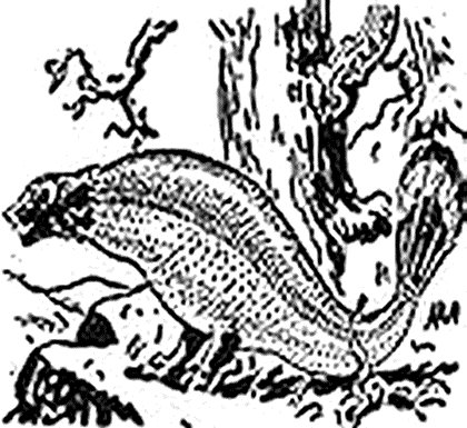
Skeleton of the now extinct cave bear (Ursus spelaeus)

Skull of the now extinct cave bear (Ursus spelaeus) on a reconstruction of the cave floor

The Star-gazer – Stone 33b of the west kennett avenue.Avebury
Weighing 15 tons, this stone is said have two faces, but only one can see.
One with a big mouth but no eye. The other lies back, watching the sky.

Picket Barrow, atop Windmill Hill, as seen from the Northern entrance. The Horse Chestnut trees in the fore ground, planted by Alexander Keiller in the 1930’s. had become infected and were removed giving a clear view.

Picket Barrow atop Windmill hill, as seen from the Northern entrance. The Horse Chestnut trees in the fore ground, planted by Alexander Keiller in the 1930’s. had become infected and were removed giving a clear view.

Old “wet plate” photograph of Stonehenge prior to any restoration or re-erection of any of the stones


Rude stone monuments in all countries their age and their uses
by James Fergussion – London 1872

Plan of Site from Rude stone monuments in all countries their age and their uses by James Fergussion – London 1872

Entrance to Dolman, in Tumulus, Plas Newydd.
Rude stone monuments in all countries their age and their uses by James Fergussion – London 1872

The circles are small, the largest being only 75 feet in diameter, and the whole group only 200 feet across, neither are the stones by any means of imposing dimensions.

The circle or rather circles, on Burn Moor, near West Water, Cumberland, are described by Mr. Williams as consisting of a 100-foot circle, formed of forty-four stones, beyond which, at a distance of 25 feet is an outer circle of fourteen large stones. A niche or square enclosure on one side of the inner circle contains a cairn 25 feet in diameter, and within the circle are four others, irregularly spaced, and measuring 21 to 25 feet in diameter; each like the circle itself, surrounded by fourteen stones. These, on being opened, were found to contain a rude chamber formed of five stones, in which were found remains of burnt bones, horns of stags, and other animals.
‘Proceedings of the Society of Antiquaries,’ iii. p.225.

Pierre Martine, located near Livernon.
The cap-stone measures 22 feet by 11 feet, and is 16 inches in thickness, and was so balanced on its two points of support that a slight pressure of the hand was sufficient to set it oscillating with a motion which it retained for some time. Alas this broke under it’s own weight and had to be concreted. This curiosity, which has puzzled many people, eventually giving rise to a legend depicting Saint Martin, the evangelist Gaul.


The more usual form of French dolmens is either square or slightly in excess of that form, seldom reaching two squares in plan, and with a height equal to its breadth. One of the finest specimens of a monument of this class is in the middle of the village of Krukenho, (Crucuno) halfway between Canuic and Erdeven, and is now nsed as a cart-shed or barn. It certainly never was covered np, though its entrance may have been closed; indeed, the stones used for that purpose still lie in front of it. From this, which may be styled a first-class dolmen of the ordinary type, down to the simple dolmen of four stones, like Kit’s Cotty house, every possible variety and gradation are to be found in France; but, so far as I know, no classification has been hit upon which would enable us to say which are the oldest or which the more modern.


Cruz Menquen dolmen from ‘La France monumentale et picturesque’ – Bonstetten 1865
For location see
prehistoricjersey.net/Dolmen_de_Cruz_Menquen.shtml
or web site links below

View of the Circles at Stanton Drew from a sketch by Percy Shelton, Esq. – 1832

Plan made by Mr. Croker, for Sir R. C. Hoare, with corrections by Sir Gardner Wilkinson – 1826

Ste-Madeleine dolmen located at St Germain-sur-Vienne, near Confolens, in Poitou.
A dolmen raised up on Romanesque design, twelfth-century pillars, sited on an Island in the Vienne River. The cap-stone, measures 12 feet by 15 feet, and is of proportionate thickness. The mass was originally supported by five columns but one having fallen away, it now rests only on four. The site was translated into a Christian chapel dedicated to saint Madeleine and is also known as Pierre Madeleine or Dolmen de la Chapelle

The sarsen stones at Ashdown from a drawing by A.L. Lewis – 1853

West Kennet Long Barrow as excavated in 1859 by Dr. Thurnam. These excavations took the form of lifting the cap-stones of the chamber, excavating the material on the floor of it, and similarly clearing about fifteen feet of the passage, working outward from the chamber. These diggings leave much to be desired (no plans or sections of the burial deposits were made) and it is fortunate that no attempt was made to clear the outer end of the passage or the entrance forecourt. This plan made at the time by W. C. Lukis.

Plan of long barrow prior to it’s destruction in 1955

Tumulus, with fallen Cromloch near Littleton-Drew, Wilts from a sketch taken in 1821

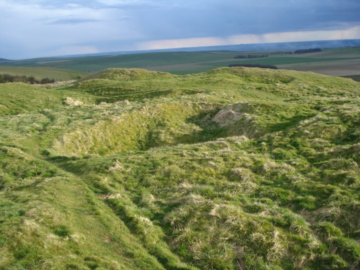
This mound lies 1/4 mile to the West of the Obelisk and may have been another Long Barrow but no evidence exists

This mound lies 1/4 mile to the West of the Obelisk and may have been another Long Barrow but no evidence exists
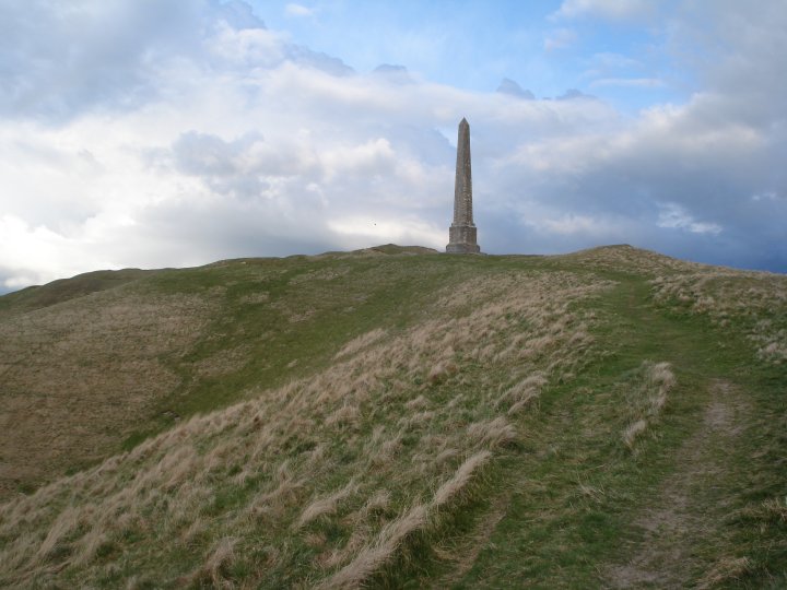
View of the Oldbury Long Barrow and the Obelisk

View of the Oldbury Long Barrow and the Obelisk

View of the Oldbury Long Barrow and the Obelisk from the A4

d – Oldbury Long Barrow
e – Obelisk
f – Round Barrow
i – Earthwork
k – Earthwork
l – Circular cavity
m, m2 – Dwelling Pits

View of the Obelisk showing the extensive disturbances made by the chalk diggings

View of Oldbury hillfort and the White horse from the A4


View of Oldbury hillfort and the Obelisk from the A4

View looking through what may have been the original entrance towards the Obelisk


View from the back of Oldbury hillfort looking towards North Down showing the defences

View from the back of Oldbury hillfort looking towards Morgan’s Hill
View from the back of Oldbury hillfort showing the extensive disturbances made by the chalk diggings. The left side of this photo includes the round barrow shown in Cunningtons 1864 map of the site.


Green Street meets the Ridgeway looking out over Avebury towards Oldbury Castle