Chance

Chance

Images expand_more 601-650 of 1,185 images
Image of La Pierre-Levée (Poitiers) (Burial Chamber) by Chance

La Pierre-Levée (Poitiers)

Burial Chamber

La Pierre Levée as a banquet table for local scholars who, ‘when they have nothing else to do, pass the time by climbing up onto the stone and banqueting there with large quantities of bottles, hams and pastries, and inscribing their names on the capstone with a knife’. Illustration from 1561 in Georg Hoefnagel’s “Civitates orbis terratum”

Image credit: Georg Hoefnagel - 1561
Image of La Pierre-Levée (Poitiers) (Burial Chamber) by Chance

La Pierre-Levée (Poitiers)

Burial Chamber

Legend says that St. Radegonde , who is buried just over the river in Église Ste-Radegonde, brought the huge capstone block on her head and the pillars in her apron. The church of Ste-Radegonde can be seen in the background on the 18th c. print of La Pierre Levée from Monuments Druidiques.

Image credit: Unknown - From Monuments Druidiques
Image of Pierre du Sacrifice (Burial Chamber) by Chance

Pierre du Sacrifice

Burial Chamber

An ancient legend tells of the “petits hommes”, the little people who were said to inhabit the forest. They were said to have built the tumulus and made it there home. They were so strong that they could carry the enormous 15 tonne blocks with their bare hands.

Image credit: M.Gomez De Soto
Image of Charente (16) (Departement) by Chance

Charente (16)

Departement

View looking East from the village of Tusson. The top of the ridge contains four huge tumuli, including Le Gros Dognon, running in a line north south. The arrow is pointing to La Justice tumulus.

Image credit: Chance - Sep 2008
Image of Lake Group (Round Barrow(s)) by Chance

Lake Group

Round Barrow(s)

The Lake group Long Barrow is aligned north-west to south-east, stands 2.5 metres high, is 42 metres long and 23 metres wide.
Records suggest it has never to have been opened or excavated in any way.

Image credit: Chance - Aug 2007
Image of Stonehenge and its Environs by Chance

Stonehenge and its Environs

Drinking cup from Hoare’s barrow No.93 which lies just north of the Cursus on Stonehenge Down

Image credit: Stonehenge and its Barrows by William Long, Esq., M.A., F.S.A. 1876
Image of Winterbourne Stoke Group (Round Barrow(s)) by Chance

Winterbourne Stoke Group

Round Barrow(s)

The Winterbourne Stoke group in 1810 showing how the group radiate out along the same axis as the original long barrow.
This group consist of the long barrow, two disc barrows, large bell barrows, and the smaller, but more numerous bowl barrows. The earthwork on the bottom left ran all the way down to the Lake group of barrows and their single, immense long barrow.
To date the road system has only been changed by a roundabout, a lay-by and the name A303.

Image credit: Sir Richard Colt-Hoare, 1810, Ancient Wiltshire, Vol.1
Image of Normanton Down and Bush Barrow by Chance

Normanton Down and Bush Barrow

Barrow / Cairn Cemetery

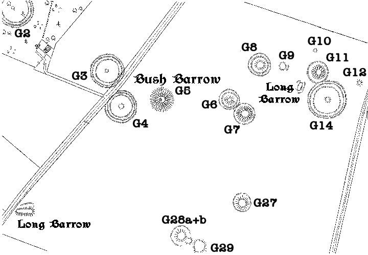
The Normanton Down barrow group in 1810 showing how the group stretch out along the ridge over looking Stonehenge.
The group contains: two small long barrows 151 and 175, eight disc barrows, including the one William Stukeley dug 159 and Bush Barrow 158.

Image credit: Sir Richard Colt-Hoare, 1810, Ancient Wiltshire, Vol.1
Image of Lake Group (Round Barrow(s)) by Chance

Lake Group

Round Barrow(s)

The Lake barrow group in 1810 showing the long barrow, two disc barrows, large bell barrows, and the smaller, but more numerous bowl barrows. The earthwork on the left ran all the way up to the Winterbourne Stoke group of barrows, while the one of the right was designed to encompass a specific area only.

Image credit: Sir Richard Colt-Hoare, 1810, Ancient Wiltshire, Vol.1
Image of Stonehenge Cursus Group (Barrow / Cairn Cemetery) by Chance

Stonehenge Cursus Group

Barrow / Cairn Cemetery

Bell-barrow,(Amesbury G43) recorded as No. 28 by Sir Richard Colt-Hoare and opened by Lord Pembroke in the year 1722 with no record of contents. Dimensions in 1957: mound dia. 99 ft; mound height 10 ft; berm width 25 ft; ditch width 18 ft; ditch depth 3 ft.

Image credit: Chance
Image of Stonehenge Cursus Group (Barrow / Cairn Cemetery) by Chance

Stonehenge Cursus Group

Barrow / Cairn Cemetery

Bell-barrow (Amesbury G43) and Twin bell-barrow (Amesbury G44).
Bell-barrow was opened by Lord Pembroke in the year 1722 with no record of contents
The Twin bell-barrow was open by Stukeley who found
In W mound: high in the mound a skeleton, head to N. This was opened again in 1803 by William Cunnington who found, south of centre, a large oblong chalk-cut pit in which was a cremation with 6 horn beads.
In E mound: Stukeley found a cremation (primary or secondary ?) in an urn, with a bronze knife-dagger, bronze awl, gold-mounted amber disc, and faience beads, amber studs, amber beads and space-plates, and beads of shale and ‘yellow glass’. He writes ‘This person was a heroin, for we found the head of her javelin in brass’.

Image credit: Chance
Image of Stonehenge Cursus Group (Barrow / Cairn Cemetery) by Chance

Stonehenge Cursus Group

Barrow / Cairn Cemetery

Plate 30 – Prospect of the West end of the Cursus of Stonehenge
From Stonehenge, A Temple Restor’d to the British Druids, by William Stukeley, 1740

The Cursus and it’s group of barrows looking east. A is the end of the Cursus and the Long Barrow; B is the gap on King’s Barrows Ridge and the course of the Aveune; C is Stonehenge with the modern route of the A303.

Image credit: William Stukeley 1740
Image of Stonehenge Cursus Group (Barrow / Cairn Cemetery) by Chance

Stonehenge Cursus Group

Barrow / Cairn Cemetery

The Cursus group in 1810 from the map of the area made by Hoare. The numbers start at 28 and progress westwards to 44. The largest barrow, Amesbury G55 was marked as No.40 by Hoare as ‘in point of size, the monarch of the plain‘

Image credit: Sir Richard Colt-Hoare, 1810, Ancient Wiltshire, Vol.i